French Alps

| French Alps | |
|---|---|
 Aerial photograph of Mont Blanc, the highest mountain in the Alps and Western Europe, from the west | |
| Highest point | |
| Peak | Mont Blanc |
| Elevation | 4,807.45 m (15,772.5 ft) |
| Coordinates | 45°50′01″N 06°51′54″E / 45.83361°N 6.86500°E |
| Naming | |
| Native name | French: Alpes françaises |
| Geography | |
 Ranges of the French Alps. | |
| French regions | Auvergne-Rhône-Alpes and Provence-Alpes-Côte d'Azur |
| Borders on | Swiss Alps, Italian Alps |
| Geology | |
| Orogeny | Alpine orogeny |
| Age of rock | Tertiary |
| Type of rock | Bündner schist, flysch and molasse |
The French Alps (French: Alpes françaises) are the portions of the Alps mountain range that stand within France, located in the Auvergne-Rhône-Alpes and Provence-Alpes-Côte d'Azur regions. While some of the ranges of the French Alps are entirely in France, others, such as the Mont Blanc massif, are shared with Switzerland and Italy.
At 4,808 metres (15,774 ft), Mont Blanc, on the France–Italy border, is the highest mountain in the Alps, and the highest Western European mountain.[1]
Notable towns in the French Alps include Grenoble, Chamonix, Annecy, Chambéry, Évian-les-Bains and Albertville.
Ranges and summits
[edit]
Ski areas
[edit]
The largest connected ski areas are:
- Les Trois Vallées (Courchevel, Méribel, La Tania, Brides-les-Bains, Saint-Martin-de-Belleville, Les Menuires, Val Thorens and Orelle): 338 slopes, 600 km of pistes.
- Portes du Soleil (Avoriaz, Châtel, Morzine, Les Gets, Saint-Jean d'Aulps, La Chapelle d'Abondance, Abondance, Montriond, Swiss resorts): 288 slopes, 650 km of slopes not entirely connected.
- Paradiski (La Plagne, Peisey-Vallandry, Les Arcs), Champagny-en-Vanoise: 239 slopes, 420 km of slopes.
- Via Lattea (Montgenèvre, Italian resorts): 214 slopes, 400 km of slopes.
- Évasion Mont-Blanc (Combloux, Megève, Saint-Gervais, Saint-Nicolas-de-Véroce, Les Contamines Monjoie): 183 slopes, 420 km of slopes not entirely connected.
- Espace Killy (Tignes, Val-d'Isère): 137 slopes, 300 km of slopes.
- Grand Massif (Flaine, Les Carroz, Morillon, Samoëns, Sixt): 134 slopes, 265 km of slopes.
- Les Aravis (La Clusaz, Manigod, La Croix Fry, Merdassier, Le Grand-Bornand): 133 slopes, 220 km of slopes not entirely connected.
- Les Grandes Rousses (L'Alpe d'Huez, Vaujany, Auris-en-Oisans, Oz-en-Oisans, Villard-Reculas): 117 slopes, 236 km of slopes.
- Serre Chevalier: 111 slopes, 250 km of slopes.
- La Forêt Blanche (Risoul, Vars): 104 slopes, 180 km of slopes.
- Les Sybelles (Le Corbier, La Toussuire, Les Bottières, Saint-Jean-d'Arves, Saint-Sorlin-d'Arves, Saint-Colomban-des-Villards): 96 slopes, 310 km of slopes.
- Valloire and Valmeinier: 83 slopes, 150 km of slopes.
- Grand Domaine (Valmorel, Saint-François-Longchamp): 82 slopes, 150 km of slopes
- Espace San Bernardo (La Rosière, La Thuile - Italy): 73 slopes, 150 km of slopes.
- Les Deux Alpes and La Grave: 69 slopes, 220 km of slopes. (+ Freeride Zone)
The other large ski areas are:
- Le Val d'Arly (Praz-sur-Arly, Notre-Dame-de-Bellecombe, Flumet): 150 km of slopes.
- L'Espace Cristal (Les Saisies, Crest-Voland): 80 km of slopes
- L'Espace Diamant is a combination of Espace Val d'Arly and Espace Cristal with 185 km of slopes
- Villard-de-Lans et Corrençon-en-Vercors: 125 km of slopes
- Valberg - Beuil les Launes: 90 km of slopes
- Espace Lumière (Pra-Loup, Val d'Allos): 170 km of slopes
- Superdévoluy - La Joue du Loup: 100 km of slopes
- Orcières-Merlette 150 km of slopes
Activities
[edit]A range of winter and summer activities are available in the French Alps. In the winter, these include skiing and snowboarding as well as alternatives such as snowshoeing, sledging. There is a range of other activities that happen such as gliding which most happens during the summer months.[2] Summer activities include hiking, mountaineering, biking and rock climbing.[3]
Gallery
[edit]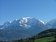 Mont Blanc (4,810 m)
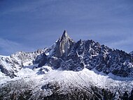 Aiguille du Dru (3,754 m)
 Aiguille Verte (4,122 m)
 Tramway du Mont-Blanc, at Bellevue Station (1,794 m) in Saint-Gervais-les-Bains
 Jacques Balmat at the side of Horace-Benedict de Saussure, "The Father of Alpinism", in a monument erected at Chamonix
 Grand Capucin (3,838 m) and its 400-meter vertical face

 Chalet in the medieval city of Yvoire


See also
[edit]- La Grande Odyssée
- 1924 Winter Olympics
- 1968 Winter Olympics
- 1992 Winter Olympics
- 2030 Winter Olympics
- List of highest paved roads in Europe
- List of mountain passes
- List of national parks in the Alps
- List of ski areas and resorts in Europe
References
[edit]- ^ "Mont Blanc shrinks by 45cm in two years". The Sydney Morning Herald. 2009-11-05. Archived from the original on 2023-02-14.
- ^ "frenchalps.co.uk - Your website dedicated to information on the French Alps". frenchalps.co.uk. Archived from the original on 2016-02-07. Retrieved 2016-01-27.
- ^ "French Alps Mountain Activities | frenchalps.co.uk". frenchalps.co.uk. Archived from the original on 2016-03-08. Retrieved 2016-01-27.
Bibliography
[edit]- Raoul Blanchard (1938–1956), Les Alpes Occidentales. Paris: Édition Arthaud. (French)
- Roger Frison-Roche (1964), Les montagnes de la terre. Paris: Flammarion. (French)
- Sergio Marazzi (2005), Atlante Orografico delle Alpi. SOIUSA. Pavone Canavese (TO): Priuli & Verlucca editori. ISBN 978-88-8068-273-8 (Italian)
- Sergio Marazzi, La "Suddivisione orografica internazionale unificata del Sistema Alpino" (SOIUSA) - article with maps and illustrations, PDF (Italian)
| Authority control databases: National |
|---|