Список ледников на острове Терстон
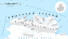
Это список ледников на острове Терстон , покрытый льдом, ледниковым рассеченным островом, длиной 215 км (134 миль), шириной 90 км (56 миль) и 15 700 км. 2 (6062 кв. Миль) в районе, лежащий в нескольких минутах от северо -западной части земли Эллсворта , Антарктида . Это третий по величине остров Антарктида , после острова Александра и острова Беркнер .
Северо -запад
[ редактировать ]
Ледник течет на север, к западу от полуострова Новиль , с запада на восток
Фоли ледник
[ редактировать ]71 ° 58′00 ″ с 101 ° 10′00 ″ в стр. / 71,9666667 ° С 101,1666667 ° w . Ледник около 4 морских миль (7,4 км; 4,6 мили), протекающий к северу от западного конца острова Терстон к востоку от Кейп -Петерсена . Назван Консультативным комитетом Соединенных Штатов по Антарктическим именам (US-ACAN) после Кевина М. Фоули, Геологическая служба США (USGS), Рестон, Вирджиния, компьютерный специалист, член команды проекта гляциологического и прибрежного изменения. [ 1 ]

Sessums Glacier
[edit]72°00′S 100°33′W / 72°S 100.55°W. A glacier flowing into the head of Henry Inlet on the north side of Thurston Island. Named by US-ACAN after Lieutenant Commander Walter Sessums, helicopter pilot in the Eastern Group of United States Navy (United States Navy) Operation Highjump, which obtained aerial photographs of Thurston Island and adjacent coastal areas, 1946-47.[2]
Rexford Glacier
[edit]72°05′00″S 100°04′00″W / 72.0833333°S 100.0666667°W. A glacier flowing northeast into the head of Wagoner Inlet on the north side of Thurston Island. Named by US-ACAN after Aviation Radioman Phillip W. Rexford, PBM Mariner aircrewman in the Eastern Group of United States Navy (United States Navy) Operation Highjump, which obtained aerial photographs of this glacier and adjoining coastal areas, 1946-47.[3]
Litz Glacier
[edit]72°07′00″S 99°04′00″W / 72.1166667°S 99.0666667°W. A glacier flowing northeast from the vicinity of Smith Peak and Litz Bluff in north-central Thurston Island. The glacier enters the west part of Peale Inlet north of Guy Peaks. Named by Advisory Committee on Antarctic Names (US-ACAN) after A.K. Litz, Chief Photographer's Mate in the Eastern Group of Operation Highjump, which obtained aerial photographs of this glacier and adjacent coastal areas, 1946-47.[4]
Robbins Glacier
[edit]72°10′00″S 98°41′00″W / 72.1666667°S 98.6833333°W. A broad glacier flowing into the head of Peale Inlet on the north side of Thurston Island. Named by Advisory Committee on Antarctic Names (US-ACAN) after Aviation Radarman James Haskin Robbins of the Eastern Group of United States Navy (United States Navy) Operation Highjump, aircrewman in the PBM Mariner seaplane that crashed on adjacent Noville Peninsula, December 30, 1946. His energy and initiative contributed to the well-being of six survivors who were rescued Jan 12, 1947 (Ball Peninsula, Mount Howell, q.v.).[5]
Noville Peninsula
[edit]From north to south
Sikorski Glacier
[edit]71°44′S 98°30′W / 71.733°S 98.500°W. Small glacier in the northeast part of the Noville Peninsula. It flows northeast to the Bellingshausen Sea between Mount Palmer and Mount Feury. First roughly delineated from air photos taken by United States Navy Operation Highjump (OpHjp), 1946-47. Named by US-ACAN for Stephen Sikorski, electronics technician on the USS Glacier, who assisted in setting up an automatic weather station on Thurston Island during the United States Navy Bellingshausen Sea Expedition in February 1960.[6]
Frankenfield Glacier
[edit]71°46′S 98°18′W / 71.767°S 98.300°W. Small glacier in the northeast part of Noville Peninsula. It flows east-northeast to Bellingshausen Sea between Mount Feury and Mulroy Island. First roughly delineated from air photos taken by United States Navy OpHjp in December 1946. Named by US-ACAN for Lieutenant (j.g.) Chester Frankenfield, meteorologist on the United States Navy Bellingshausen Sea Expedition, who established an automatic weather station on Thurston Island in February 1960.[7]
Pelter Glacier
[edit]71°57′00″S 98°22′00″W / 71.95°S 98.3666667°W. A glacier about 5 nautical miles (9.3 km; 5.8 mi) long, flowing from the east side of the Noville Peninsula into the west side of Murphy Inlet. Delineated from air photos taken by United States Navy (United States Navy) Squadron VX-6 in January 1960. Named by Advisory Committee on Antarctic Names (US-ACAN) for J.A. Pelter, aerial photographer with the Byrd Antarctic Expedition (ByrdAE) in 1933-35.[8]
Northeast
[edit]Glacier to the east of Noville Peninsula on the north side of the island, from west to east
Warr Glacier
[edit]72°11′00″S 98°19′00″W / 72.1833333°S 98.3166667°W. A broad glacier flowing north into the southwest arm of Murphy Inlet. Named by Advisory Committee on Antarctic Names (US-ACAN) after William Warr, Aviation Machinist's Mate in the Eastern Group of United States Navy (United States Navy) Operation Highjump, 1946-47. Warr and five others survived the December 30, 1946 crash of a PBM Mariner seaplane on adjacent Noville Peninsula.[9]
Mincer Glacier
[edit]72°10′00″S 97°55′00″W / 72.1666667°S 97.9166667°W. A broad glacier flowing from Zuhn Bluff into the southeast arm of Murphy Inlet on the north side of Thurston Island. Named by Advisory Committee on Antarctic Names (US-ACAN) after Lieutenant Dale F. Mincer, co-pilot of PBM Mariner aircraft in the Eastern Group of United States Navy (United States Navy) Operation Highjump, which obtained aerial photographs of Thurston Island and adjacent coastal areas, 1946-47.[10]
Goff Glacier
[edit]72°14′00″S 97°26′00″W / 72.2333333°S 97.4333333°W. A broad glacier flowing from Parker Peak into the head of Koether Inlet on the north side of Thurston Island. Named by Advisory Committee on Antarctic Names (US-ACAN) after Lieutenant (jg) Robert G. Goff, co-pilot of PBM Mariner aircraft in the Eastern Group of United States Navy (United States Navy) Operation Highjump, which obtained aerial photographs of Thurston Island and adjacent coastal areas, 1946-47.[11]
Payne Glacier
[edit]71°55′00″S 96°42′00″W / 71.9166667°S 96.7°W. A glacier in the north part of Evans Peninsula, Thurston Island. It flows into the sea east of Cape Walden. Named by Advisory Committee on Antarctic Names (US-ACAN) after Photographer's Mate J.B. Payne, aircrewman in the Eastern Group of United States Navy (United States Navy) Operation Highjump, which obtained aerial photographs of Thurston Island and adjacent coastal areas, 1946-47.[12]
Deadmond Glacier
[edit]71°58′S 96°20′W / 71.967°S 96.333°W. Glacier about 6 nautical miles (11 km; 6.9 mi) long, flowing from the east side of Evans Peninsula on Thurston Island into Cadwalader Inlet. Discovered by the United States Navy Bellingshausen Sea Expedition in February 1960. Named by US-ACAN for Lieutenant Commander Robert B. Deadmond, executive officer of the USS Burton Island, forming part of this expedition.[13]
Marck Glacier
[edit]72°16′00″S 97°02′00″W / 72.2666667°S 97.0333333°W. A glacier flowing into the southwest extremity of Cadwalader Inlet on the north side of Thurston Island. Named by Advisory Committee on Antarctic Names (US-ACAN) after Aviation Machinist's Mate George H. Marck, aircrewman in the Eastern Group of United States Navy (United States Navy) Operation Highjump, which obtained aerial photographs of Thurston Island and adjacent coastal areas, 1946-47.[14]
Mahaffey Glacier
[edit]72°18′00″S 96°26′00″W / 72.3°S 96.4333333°W. A glacier flowing into the head of Morgan Inlet at the east end of Thurston Island. Named by Advisory Committee on Antarctic Names (US-ACAN) after J.S. Mahaffey, Photographer's Mate in the Eastern Group of United States Navy (United States Navy) Operation Highjump, which obtained aerial photographs of Thurston Island and adjacent coastal areas, 1946-47.[15]
Southwest coast
[edit]Glaciers to the west of Von der Wall Point, from west to east:
Kannheiser Glacier
[edit]72°10′S 101°52′W / 72.167°S 101.867°W. A glacier about 4 nautical miles (7.4 km; 4.6 mi) long, lying 12 nautical miles (22 km; 14 mi) east-southeast of Cape Flying Fish on Thurston Island and flowing south into Abbot Ice Shelf. First delineated from air photos taken by United States Navy OpHjp in December 1946. Named by US-ACAN for Lieutenant Commander William Kannheiser, United States Navy, helicopter pilot aboard the USS Glacier, who explored and photographed new Thurston Island features in February 1960.[16]
Craft Glacier
[edit]72°11′S 101°33′W / 72.183°S 101.550°W. A valley glacier about 5 nautical miles (9.3 km; 5.8 mi) long, lying west of Hendersin Knob on Thurston Island and flowing south to Abbot Ice Shelf in Peacock Sound. First delineated from air photos taken by United States Navy OpHjp in December 1946. Named by US-ACAN for Ens. Charles Craft, United States Navy, helicopter pilot on USS Glacier who made exploratory flights at Thurston Island in February 1960.[17]
Rochray Glacier
[edit]72°11′S 101°21′W / 72.183°S 101.350°W. A glacier about 5 nautical miles (9.3 km; 5.8 mi) long, located just east of Hendersin Knob on Thurston Island and flowing south to Abbot Ice Shelf in Peacock Sound. First delineated from air photos taken by United States Navy OpHjp in December 1946. Named by US-ACAN for Lieutenant (j.g.) Samuel Rochray, United States Navy, helicopter pilot on USS Glacier in February 1960, who made several flights in which new parts of Thurston Island were discovered.[18]
Cox Clacier
[edit]72°11′S 101°15′W / 72.183°S 101.250°W. A small glacier immediately east of Rochray Glacier on Thurston Island, flowing south to Abbot Ice Shelf in Peacock Sound. Delineated from air photos taken by United States Navy Squadron VX-6 in January 1960. Named by US-ACAN for Lieutenant (j-g.) Jerry G. Cox, United States Navy, helicopter pilot aboard the USS Burton Island, who made exploratory flights to Thurston Island in February 1960.[19]
Hale Glacier
[edit]72°12′S 100°48′W / 72.200°S 100.800°W. A glacier about 6 nautical miles (11 km; 6.9 mi) long, located just east of Mount Simpson on Thurston Island and flowing southwest to Abbot Ice Shelf in Peacock Sound. Delineated from air photos taken by United States Navy Squadron VX-6 in January 1960. Named by US-ACAN for Lieutenant (j-g.) Bill J. Hale, United States Navy, helicopter pilot aboard USS Burton Island who made exploratory flights to Thurston Island in February 1960.[20]
Myers Glacier
[edit]72°14′S 100°18′W / 72.233°S 100.300°W. A valley glacier about 7 nautical miles (13 km; 8.1 mi) long, flowing southwest from Mount Noxon on Thurston Island to Abbot Ice Shelf in Peacock Sound. Delineated from aerial photographs taken by United States Navy Squadron VX-6 in January 1960. Named by US-ACAN for Lieutenant (j.g.) Dale P. Myers, United States Navy, helicopter pilot aboard USS Burton Island who made exploratory flights to Thurston Island in February 1960.[21]
Bellisime Glacier
[edit]72°19′00″S 99°53′00″W / 72.3166667°S 99.8833333°W. A glacier about 4 nautical miles (7.4 km; 4.6 mi) long flowing south from Thurston Island east of Myers Glacier. Named by Advisory Committee on Antarctic Names (US-ACAN) after Lynda B. Bellisime, United States Geological Survey (USGS), Flagstaff, Arizona, part of the United States Geological Survey (USGS) team that compiled the 1:5,000,000-scale Advanced Very High Resolution Radiometer maps of Antarctica and the 1: 250,000-scale Landsat TM image maps of the Siple Coast area in the 1990s.[22]
Bearman Glacier
[edit]72°21′00″S 99°10′00″W / 72.35°S 99.1666667°W. A glacier whose head is east of Mount Howell in central Thurston Island. The glacier flows south into Schwartz Cove on the south side of the island. Named by Advisory Committee on Antarctic Names (US-ACAN) after F.O. Bearman, Photographer's Mate in the Eastern Group of United States Navy (United States Navy) Operation Highjump, which obtained aerial photographs of this glacier and adjacent coastal areas, 1946-47.[23]
Bulbur Glacier
[edit]72°27′S 98°33′W / 72.45°S 98.55°W. A glacier in south-central Thurston Island; it flows south along the west side of Boker Rocks into O'Dowd Cove. Named by Advisory Committee on Antarctic Names (US-ACAN) after E.R. Bulbur, Photographer's Mate in the Eastern Group of United States Navy (United States Navy) Operation Highjump, which obtained aerial photographs of Thurston Island and adjacent coastal areas, 1946-47.[24]
Southeast coast
[edit]Glaciers to the east of Von der Wall Point, from west to east:
Hlubeck Glacier
[edit]72°30′S 97°09′W / 72.5°S 97.15°W. A glacier 9 nautical miles (17 km; 10 mi) west of Long Glacier in southeast Thurston Island. It flows south along the east side of Shelton head into Abbot Ice Shelf. Named by Advisory Committee on Antarctic Names (US-ACAN) after Aviation Radioman Vernon R. Hlubeck, PBM Mariner aircrewman in the Eastern Group of United States Navy (United States Navy) Operation Highjump, which obtained aerial photographs of Thurston Island and adjoining coastal areas, 1946-47.[25]
Long Glacier
[edit]72°30′S 96°47′W / 72.500°S 96.783°W. Glacier about 8 nautical miles (15 km; 9.2 mi) long in the southeast part of Thurston Island. It flows south to Abbot Ice Shelf, 14 nautical miles (26 km; 16 mi) west of Harrison Nunatak. Mapped by USGS from surveys and United States Navy air photos, 1960-66. Named by US-ACAN for Fred A. Long, Jr., aviation machinist of United States Navy Squadron VX-6, who wintered at Little American V in 1957 and was in Antarctica in the 1960-61 and 1962-63 seasons.[26]
Savage Glacier
[edit]72°25′S 96°05′W / 72.417°S 96.083°W. Glacier at the east end of Thurston Island, lying south of Tierney Peninsula and flowing east to Seraph Bay. Discovered on helicopter flights from the USS Glacier and Burton Island by personnel of the United States Navy Bellingshausen Sea Expedition in February 1960. Named by US-ACAN for Lieutenant John Savage, United States Navy, Dental Officer aboard the Glacier who assisted in establishing geodetic control points in the area.[27]
Levko Glacier
[edit]72°25′00″S 96°02′00″W / 72.4166667°S 96.0333333°W. A glacier flowing from Pallid Crest to the east end of Thurston Island. It enters Seraph Bay between Tierney Peninsula and Simpson Bluff. Named by Advisory Committee on Antarctic Names (US-ACAN) after G. Levko, Photographer's Mate in the Eastern Group of United States Navy (United States Navy) Operation Highjump, which obtained aerial photographs of Thurston Island and adjacent coastal areas, 1946-47.[28]
References
[edit]- ^ Foley Glacier USGS.
- ^ Sessums Glacier USGS.
- ^ Rexford Glacier USGS.
- ^ Litz Glacier USGS.
- ^ Robbins Glacier USGS.
- ^ Alberts 1995, p. 675.
- ^ Alberts 1995, p. 257.
- ^ Pelter Glacier USGS.
- ^ Warr Glacier USGS.
- ^ Mincer Glacier USGS.
- ^ Goff Glacier USGS.
- ^ Payne Glacier USGS.
- ^ Alberts 1995, p. 178.
- ^ Marck Glacier USGS.
- ^ Mahaffey Glacier USGS.
- ^ Alberts 1995, p. 382.
- ^ Alberts 1995, p. 159.
- ^ Alberts 1995, p. 625.
- ^ Alberts 1995, p. 158.
- ^ Alberts 1995, p. 305.
- ^ Alberts 1995, p. 514.
- ^ Bellisime Glacier USGS.
- ^ Bearman Glacier USGS.
- ^ Bulbur Glacier USGS.
- ^ Hlubeck Glacier USGS.
- ^ Alberts 1995, p. 442.
- ^ Alberts 1995, p. 650.
- ^ Levko Glacier USGS.
Sources
[edit]- Альбертс, Фред Г., изд. (1995), Географические названия Антарктики (PDF) (2 Ed.), Совет Соединенных Штатов по географическим именам , извлеченные 3 декабря 2023 г.
 Эта статья включает в себя материалы общественного достояния с веб -сайтов или документов Совета США по географическим именам .
 - «Грейшер Bearman» , Информационная система географических имен , Геологическая служба США , Министерство внутренних дел Соединенных Штатов
- «Ледник Беллисме» , Информационная система географических имен , Геологическая служба США , Министерство внутренних дел США
- «Ледник из Булбура» , Информационная система географических имен , Геологическая служба США , Министерство внутренних дел Соединенных Штатов
- «Ледник Фоли» , Информационная система географических имен , Геологическая служба США , Министерство внутренних дел Соединенных Штатов
- «Goff Glacier» , Информационная система географических имен , Геологическая служба Соединенных Штатов , Министерство внутренних дел Соединенных Штатов
- «Ледник Хлюбек» , Информационная система географических имен , Геологическая служба США , Министерство внутренних дел США
- «Левко ледник» , Информационная система географических имен , Геологическая служба США , Министерство внутренних дел США
- «Litz Glacier» , Информационная система географических имен , Геологическая служба Соединенных Штатов , Министерство внутренних дел Соединенных Штатов
- «Ледник Махаффи» , Информационная система географических имен , Геологическая служба США , Министерство внутренних дел Соединенных Штатов
- «Глокер Марка» , Информационная система географических имен , Геологическая служба США , Министерство внутренних дел США
- «Минсер ледник» , Информационная система географических имен , Геологическая служба США , Министерство внутренних дел Соединенных Штатов
- «Ледник Пейна» , Информационная система географических имен , Геологическая служба США , Министерство внутренних дел США
- «Глочер Пелтера» , Информационная система географических имен , Геологическая служба США , Министерство внутренних дел Соединенных Штатов
- «Ледник Рексфорда» , Информационная система географических имен , Геологическая служба США , Министерство внутренних дел США.
- «Ледник Роббинса» , Информационная система географических имен , Геологическая служба США , Министерство внутренних дел Соединенных Штатов
- «Ледник Сессума» , Информационная система географических имен , Геологическая служба США , Министерство внутренних дел США
- «Ледник Уорда» , Информационная система географических имен , Геологическая служба США , Министерство внутренних дел Соединенных Штатов
![]() Эта статья включает в себя материалы общественного достояния с веб -сайтов или документов Геологической службы США .
Эта статья включает в себя материалы общественного достояния с веб -сайтов или документов Геологической службы США .