Черная река (Висконсин)
| Черная река | |
|---|---|
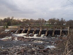 Плотина Черной реки в Фолс Блэк -Ривер | |
 Map of the Black River watershed | |
| Physical characteristics | |
| Source | |
| • location | Black Lake, Taylor County, Wisconsin |
| Mouth | |
• location | Mississippi River in La Crosse, Wisconsin |
• elevation | 630 ft (190 m)[1] |
| Length | 190 miles (310 km) |
| Basin size | Approximately 2,400 sq mi (6,200 km2)[2] |
| Basin features | |
| River system | Mississippi River |
Черная река -это река на западе центрального Висконсина и приток реки Миссисипи . Река составляет около 190 миль (310 км) длиной. [ 3 ] В течение 19 -го века сосновые бревна были сняты вниз по черному, направляясь к лесопилкам в La Crosse и точками за пределами.
География
[ редактировать ]
The river begins in central Wisconsin, rising in Taylor County at 45 ° 19'00 ″ с.ш. 90 ° 15′20 ″ стр. / 45,31667 ° с.ш. 90,25556 ° С примерно в 2,5 милях (4,0 км) к западу от деревни Риб -Лейк . [ 1 ] Он течет юго-юго-запад через Медфорд , Гринвуд , Нейлсвилл и Блэк-Ривер-Фолс . Черная река впервые смешивается с рекой Миссисипи в озере Оноласка в верхней реке Миссисипи национальной дикой природы и рыбного убежища . Нижние 10 миль (16 км) канала реки были поглощены озером Оноласка, обдумывание реки Миссисипи, сформированное за шлюзой и плотиной № 7 в Onalaska . Река выходит из озера Оноласка через канал между Французским островом и городом Ониласка и возвращается к реке Миссисипи в 43°49′12″N 91°15′26″W / 43.82000°N 91.25722°W,[1] к северо -западу от La Crosse .

The Black River can be divided into two sections by the dam at Black River Falls. The upstream section averages 6.6 feet/mile gradient, while the lower section through the Driftless Area only averages 1.7 feet/mile gradient.[4] An additional distinction is that the upper section has a substrate predominantly rocky and soil that contributes tannin, while the lower section has a predominantly sandy substrate. The tannin content of the water is the source of the river's name.
The East Fork Black River rises in Wood County at 44°35′26″N 90°17′49″W / 44.59056°N 90.29694°W, southwest of Marshfield and flows 57.5 miles (92.5 km)[3] south and west into Lake Arbutus on the Black River at 44°25′50″N 90°41′41″W / 44.43056°N 90.69472°W.[5]
The Little Black River is formed by the confluence of the East and West Branches at 45°07′51″N 90°16′00″W / 45.13083°N 90.26667°W and flows into the Black River at 45°06′39″N 90°20′57″W / 45.11083°N 90.34917°W south of Medford.[6] The West Branch Little Black River rises at 45°15′59″N 90°15′07″W / 45.26639°N 90.25194°W, south of Rib Lake and less than 2 miles (3.2 km) from the source of the main branch of the Black River.[7] The East Branch Little Black River rises at 45°14′45″N 90°10′49″W / 45.24583°N 90.18028°W south of Rib Lake.[8]
History
[edit]The earliest mention of the Black River may be in 1661, when a French Jesuit priest reported that a band of Huron Indians had taken refuge near its headwaters, where they were starving. The priest, René Ménard, tried to reach them from Lake Superior by canoe, but disappeared somewhere in the wilderness.[9]
At the time of the 1837 Treaty of St. Peters, the Ojibwe dominated the upper Black. The lower Black generally formed the border between the Lakota to the west and the Ho-Chunk to the east.[10] That treaty opened up northern Wisconsin for logging. At that time, the lower Black flowed through a mosaic of oak and other hardwood. But the upper Black flowed through prime pinelands, particularly in what would become Clark County.[11] Before lumbering, the Black River is estimated to have drained 7% of Wisconsin's pinelands.[12]

In 1839, Jacob Spaulding and Robert and Andrew Wood led an expedition from Prairie du Chien up the Mississippi and the Black into the forest and built a sawmill at the future site of Black River Falls.[13] In 1841 a group of Mormons from Nauvoo, Illinois came up the Black and began cutting logs around Black River Falls.[14] In 1842 they floated a raft of their logs down the Black and Mississippi to Nauvoo, demonstrating the feasibility of this transport.[13] The lumber was used to construct the Nauvoo Temple and the Nauvoo House.[14] By 1847, thirteen mills on the Black River produced over 6 million board feet of lumber. Sawmills on the Black contributed to the growth of Neillsville, Black River Falls, and La Crosse. By 1872 the Black produced 300 million board feet of lumber per year.[13]
The river has also been used to transport coal and petroleum products.[15]
Crossings
[edit]

A ferry operated by Alex McGilvray crossed the river near La Crosse, starting in 1861. This was supplanted by a series of seven bowstring truss bridges were built during 1891-92 to bring a La Crosse County road through backwaters of the Black River and then cross the Black River itself, connecting the city of La Crosse with rural Trempealeau County.[16]
References
[edit]- ^ Jump up to: a b c "Black River". Geographic Names Information System. United States Geological Survey, United States Department of the Interior.
- ^ "The Black River Basin". dnr.wisconsin.gov. Wisconsin Department of Natural Resources. Retrieved 12 August 2022.
- ^ Jump up to: a b U.S. Geological Survey. National Hydrography Dataset high-resolution flowline data. The National Map Archived 2012-03-29 at the Wayback Machine, accessed October 5, 2012
- ^ Black River – WDNR Archived October 10, 2007, at the Wayback Machine
- ^ "East Fork Black River". Geographic Names Information System. United States Geological Survey, United States Department of the Interior.
- ^ "Little Black River". Geographic Names Information System. United States Geological Survey, United States Department of the Interior.
- ^ "West Branch Little Black River". Geographic Names Information System. United States Geological Survey, United States Department of the Interior.
- ^ U.S. Geological Survey Geographic Names Information System: East Branch Little Black River
- ^ Schmirler, A. A. A., "Wisconsin's Lost Missionary: The Mystery of Father Rene Menard", The Wisconsin Magazine of History, Volume 45, number 2, winter, 1961-1962.
- ^ Grossman, Zoltan; Marily B. Crews-Nelson; Laura Exner; Michael Gallagher; Amelia R. Janes; Jeffry Maas (1998). Wisconsin's Past and Present - A Historical Atlas. Madison, Wisconsin: The University of Wisconsin Press. pp. 9–11. ISBN 029915940X.
- ^ Finley, Robert W.,"Finley's Presettlement Vegetation" Archived 2013-12-05 at the Wayback Machine, 1976, University of Wisconsin.
- ^ Vogel, John N. (Spring 1983). "The Round Lake Logging Dam: A Survivor of Wisconsin's Log-driving Days". Wisconsin Magazine of History. 66 (3): 170–191. Retrieved 2011-09-21.
- ^ Jump up to: a b c Fries, Robert F. (1951). Empire in Pine - The Story of Lumbering in Wisconsin 1830-1900. Madison: The State Historical Society of Wisconsin. pp. 20, 55.
- ^ Jump up to: a b Draper, Fred W. (1936-01-23). "Early Clark and Jackson Counties History - An Unwritten Page". Neillsville Press. Retrieved 2013-12-10.
- ^ BlackRiverfalls.com - Домашний архив 9 февраля 2008 г., на The Wayback Machine
- ^ Патриция Маркс (июнь 1979 г.). «Национальный реестр исторических мест Несколько недвижимости документации: Ван Луон район дикой природы Truss Bridge TR» . Служба национальных парков . Получено 13 января 2017 года .
| Международный | |
|---|---|
| Национальный | |
| Другой | |