Мур -остров

Родное имя: Остров Мууро | |
|---|---|
 Остров Муро в 2014 году | |
 Мур -остров | |
| География | |
| Расположение | Залив Сантандер |
| Координаты | 43 ° 28′24 ″ с.ш. 3 ° 45′21 ″ С / 43,473421 ° с.ш. 3,755768 ° С |
| Область | 2 га (4,9 акра) |
| Высокая высота | 27,5 м (90,2 фута) |
| Администрация | |
| Город | Сантандер, Испания |
| Автономное сообщество | |
| Округ | Залив Сантандер |
| Демография | |
| Население | 0 |
Остров Муро ( испанский : Исла де Муро ), первоначально остров Могро ( Исла де Могро ), представляет собой небольшой необитаемый остров в Бискайском заливе , расположенный у полуострова Магдалена . Он находится недалеко от входа в залив Сантандер недалеко от города Сантандер , Кантабрия вдоль северного побережья Испании . Остров составляет приблизительно 2 гектара (0,02 км²) и лежит около 0,75 км (0,5 миль) от входа в гавань. [ 1 ] [ 2 ]
История
[ редактировать ]
Первоначальным названием острова, найденным в документах 16-го века, было остров Могро. В 18 -м веке ошибка транскрипции со стороны картографа Висенте Тофиньо де Сан Мигель сменила название на остров Муро. [ 3 ]
В июле 1812 года, во время войны на полуострове , испанский союзник Великобритания захватил остров из сил Наполеона, что позволило испанским корабли устроиться в Сардинеро .
Единственная структура на острове-маяк 19-го века, который сейчас автоматизирован. До 1921 года он был занят двумя хранителями маяка, которые часто изолировали штормами. В 1865 году один из хранителей был сметен в море во время шторма и утонул. В 1895 году один из хранителей умер внезапно, но из -за шторма его тело не могло быть эвакуировано в течение некоторого времени. Еще одна смерть была записана, когда сын хранителя маяка проскользнул, когда он собирался наступить на Скалистый остров и умер. [ 3 ]
In February 2014, a spectacular photograph of a wave crashing over the lighthouse appeared in newspapers around the world, including on the cover of the International New York Times.[3]
Plants and wildlife
[edit]
Mouro Island has a high biodiversity of fish and plant life in its waters, with more than 39 species of fish found nearby. It was declared a marine reserve in 1986, with a perimeter extending to 300 meters surrounding the island. Plants found on the island include heath (Erica vagans), gorse (ulex), broom (genisteae) and the eagle fern (Pteridium aquilinum).[4] Carpobrotus edulis is also found on the island, thought to be brought there by a lighthouse keeper.
Mouro Island is an important habitat for seabirds, particularly European storm petrels and herring gulls. In 2014, Spain's Ministry of Agriculture, Food and Environment declared Mouro Island to be a Special Protection Area (SPA) to ensure the conservation of the birds that inhabit this area. It was estimated that fewer than 150 of the storm petrel lived in the area. It is illegal to bring cats, rats and other mammals onto the island. A smaller islet to the northwest, Islote la Corbera, is also part of the protected area.[5]
World Oceans Day
[edit]An annual swim and scuba diving event is held around Mouro Island to mark World Oceans Day each June. It features an island "hugging" event, in which surfers and kayakers completely encircle the island. The event is held to raise awareness of the importance of conserving the seas and oceans.[6]
Gallery
[edit]-
 Yacht race in 2009
 -
 Island with lighthouse and lodgings, as seen in 2013
 -
 View of the island as seen from Sardinero
 -
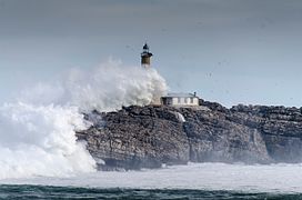 Waves crash over the lighthouse


See also
[edit]References
[edit]- ^ Anonym, Anonym (1854). Atlantic Navigator. p. 62. ISBN 9783861951704. Retrieved 4 September 2016.
- ^ Bay of Biscay Pilot, West Coast of France and the North Coast of Spain from Ushant to Cape Toriñana. United States Hydrographic Office. 1917. p. 447. Retrieved 4 September 2016.
- ^ Jump up to: a b c Méndez, Julián (16 February 2014). "El faro que se ve en todo mundo" (in European Spanish). Retrieved 4 September 2016.
- ^ "Boletín Oficial de Cantabria". cantabria.es. 29 September 2012. Retrieved 4 September 2016.
- ^ "La isla de Mouro ya es oficialmente refugio de aves". El Diario Montanes (in European Spanish). 17 July 2014. Retrieved 4 September 2016.
- ^ "La travesía a nado y un abrazo a la Isla de Mouro, este domingo por el Día de los Océanos". El Diario. 3 June 2015. Retrieved 4 September 2016.
External links
[edit] Media related to Isla de Mouro at Wikimedia Commons