Кукри холмы

| Кукри холмы | |
|---|---|
 Ледник ледник | |
| Самая высокая точка | |
| Возвышение | 2000 м (6600 футов) |
| Координаты | 77 ° 44 'с 162 ° 42′E / 77,733 ° S 162,700 ° E |
| География | |
 | |
| Континент | Антарктида |
| Область | Виктория Земля |
Кукри холмы ( 77 ° 44 'с 162 ° 42′E / 77,733 ° S 162,700 ° E ) является выдающимся трендовым диапазоном восток-запад, высотой около 25 морских миль (46 км) и более 2000 метров (6600 футов), образуя раздел между ледником Феррар на юге и ледника Тейлор и долиной Тейлор на севере, в Индии. Виктория Лэнд , Антарктида. [ 1 ] Они находятся к югу от Асгардского хребта , к востоку от горов Квартермен и к северу от хребта Королевского общества .
Холмы были обнаружены экспедицией Discovery (1901–04) и, вероятно, названным так, потому что его форма напоминает форму Кукри , ножа гуркха. [ 1 ]
Топография
[ редактировать ]Западной кончиком холмов Кукри - гора Брирли, где ледник Тейлора отделяется от ледника Феррара , а ледник Тейлор течет на северо -востоке и ледник Феррар, текущий на юго -востоке. [ 2 ] Хиллз растягивается на восток с выдающимися вершинами с запада на восток, включая гору Коутс, Пик Сентинел, Бонни Ригель, Нуссбаум Регтель, Хребет Эндрю и гору Барнс, где холмы заканчиваются в Нью -Харборе . Ледник Тейлор и долина Тейлора пробегают вдоль северной стороны, в то время как ледник Феррар проходит вдоль южной стороны. В холмах есть несколько маленьких ледников, в том числе ледник, ледник Калкин, ледник Хьюз, ледник Соллас, ледник Марра, ледник Каламон, ледник Говард, ледник Полумесяца и ледник Уэльса. [ 3 ]
Функции
[ редактировать ]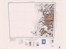

Пики и другие особенности, с запада на восток, включают в себя:
Точка возвышения
[ редактировать ]77 ° 48 'с 161 ° 39′E / 77,800 ° S 161,650 ° E . Смелый рок -точка, которая образует западный конец холмов Кукри, с видом на ледник Тейлор. Название является одной из групп в области, связанной с обследованием, применяемой NZGB в 1993 году. [ 4 ]
Эйэгсс Cirque
[ редактировать ]77 ° 48 'с 161 ° 57′E / 77,800 ° S 161,950 ° E Cirque 2 мили (3 км ) к востоку от ледника Южной Америки на южных утесах холмов Кукри. Название является одной из групп в области, связанной с обследованием, применяемой в 1993 году Новой Зеландии Географической доской ; «Очки» относится к окуляру экологического телескопа .. [ 5 ]
Гора Брирли
[ редактировать ]77 ° 48 'с 161 ° 45′E / 77,800 ° S 161,750 ° E . Шравный пик, высокая высота 2010 метров (6590 футов), который является самой западной вершиной холмов Кукри. Названной партией Западного путешествия, возглавляемой Томасом Гриффитом Тейлором , Британской Антарктической экспедиции, 1910–13. [6]
Mount Coates
[edit]77°48′S 162°05′E / 77.800°S 162.083°E Peak, 2,060 metres (6,760 ft) high, just east of Borns Glacier in the Kukri Hills. Named by the Western Journey Party, led by Taylor, of the BrAE, 1910-13.[7]
Sentinel Peak
[edit]77°47′S 162°23′E / 77.783°S 162.383°E. A conspicuous, pointed peak over 2,000 metres (6,600 ft) high, standing at the north side of Ferrar Glacier and forming the highest point in the south-central part of the Kukri Hills. Discovered and named by the Discovery expedition 1901–04 under Scott.[8]
Duff Peak
[edit]77°47′S 162°27′E / 77.783°S 162.450°E. A peak 1 nautical mile (1.9 km; 1.2 mi) east-southeast of Sentinel Peak, rising to 1,945 metres (6,381 ft) at the head of Hughes Glacier in Kukri Hills. Named in 1992 by US-ACAN after Roger S. Duff (d. 1978), for 30 years director of the Canterbury Museum, Christchurch, New Zealand. To celebrate the Museum's centenary in 1970, a Hundredth Anniversary Wing was planned which would incorporate a National Antarctic Exhibition, Research and Reference Center. A landmark of Dr. Duff's administration, the Antarctic wing was opened on March 4, 1977.[9]
Rahi Peak
[edit]77°44′S 162°49′E / 77.733°S 162.817°E. A prominent mountain rising to 1,830 m (6,000 ft) between the head of Moa Glacier and Goldman Glacier. The word "rahi" is Māori in origin, meaning "big". The name was applied by the New Zealand Geographic Board (NZGB) in 1998.[10]
Young Hill
[edit]77°38′S 163°26′E / 77.633°S 163.433°E. An ice-free hill about 3,300 ft (1,000 m) high, 1 mi (1.6 km) northeast of Hallam Peak. It was named by the New Zealand Geographic Board (NZGB) in 1998 for New Zealand ornithologist Euan C. Young, whose Antarctic research spanned 30 years, beginning in the 1959-60 field season.[11]
Hallam Peak
[edit]77°38′54″S 163°23′00″E / 77.648245°S 163.383422°E. A distinctive rock peak in the Kukri Hills. The peak rises to 900 metres (3,000 ft) between the heads of Von Guerard Glacier and Aiken Glacier and provides an unobstructed view of the Lake Fryxell locality of Taylor Valley. Named by Advisory Committee on Antarctic Names (US-ACAN) (1997) after Dr. Cheryl A. Hallam, geographer, U.S. Geological Survey (USGS), who specializes in geographic information systems; worked four summer seasons in Antarctica, 1994-95, 1995-96, 1996-97 and 1999-00.[12]
Mount Barnes
[edit]77°38′S 163°35′E / 77.633°S 163.583°E. A peak, 985 metres (3,232 ft) high, surmounting the west-central side of New Harbour and marking the east end of the Kukri Hills. Discovered by the Discovery expedition, 1901–04, under Robert Falcon Scott, and named New Harbour Heights. It was renamed Mount Barnes after a Canadian ice physicist by Scott's second expedition, the British Antarctic Expedition, 1910–13.[13]
Glaciers
[edit]There are a number of small glaciers, mostlly flowing north towards Taylor Valley. Most do not reach the valley floor. From west to east they are:
South America Glacier
[edit]77°49′S 161°47′E / 77.817°S 161.783°E. Small glacier near the southwest corner of the Kukri Hills. The ice hangs down a cliff 2,000 m high, and takes a form similar to the continent for which it is named. Named by the Western Journey Party, led by Taylor, of the BrAE, 1910-13.[14]
Borns Glacier
[edit]77°47′S 162°01′E / 77.783°S 162.017°E. Glacier immediately W of Mount Coates, flowing north from the Kukri Hills. Charted by the BrAE under Scott, 1910-13. Named by the US-ACAN for Harold W. Borns, Jr., USARP geologist who made investigations in the area during 1960-61.[15]
Hughes Glacier
[edit]
77°44′S 162°27′E / 77.733°S 162.450°E. Small alpine glacier flowing toward Lake Bonney in Taylor Valley from the Kukri Hills on the south, in Victoria Land. Mapped by the Western Geological Party led by Taylor of the BrAE (1910-13) and named for Prof. McKenny Hughes, geologist, of Cambridge.[16]
Sollas Glacier
[edit]
77°43′S 162°36′E / 77.717°S 162.600°E. Glacier between Marr and Hughes Glaciers, flowing from the Kukri Hills toward the east end of Lake Bonney in Taylor Valley. Charted and named by the BrAE under Scott, 1910-13, for William J. Sollas, professor of geology at Oxford.[17]
Marr Glacier
[edit]77°43′S 162°44′E / 77.717°S 162.733°E. Glacier 2 nautical miles (3.7 km; 2.3 mi) west of Goldman Glacier, flowing north from the Kukri Hills into Taylor Valley. Charted by the BrAE under Scott, 1910-13, who it appears also applied the name.[18]
Moa Glacier
[edit]77°42′54″S 162°47′26″E / 77.714888°S 162.790511°E. A valley glacier between Marr Glacier and Goldman Glacier in Kukri Hills. It flows north into Taylor Valley but terminates midway down the south wall of the valley. Named by New Zealand Geographic Board (NZGB) (1998) after an extinct New Zealand bird.[19]
Goldman Glacier
[edit]77°42′S 162°51′E / 77.700°S 162.850°E. Glacier 2 nautical miles (3.7 km; 2.3 mi) east of Marr Glacier, flowing north from the Kukri Hills into Taylor Valley. Named by the US-ACAN for USARP biologist Charles R. Goldman, who made studies in the area in the 1962-63 season.[20]
Kitticarrara Glacier
[edit]77°43′S 163°02′E / 77.717°S 163.033°E. Short, steep glacier 1 nautical mile (1.9 km; 1.2 mi) south of Howard Glacier in the Kukri Hills, flowing east-southeast into Ferrar Glacier. }Named by the Western Journey Party, led by Taylor, of the BrAE, 1910-13. The name was suggested by F. Debenham after a sheep station in New South Wales.[21]
Howard Glacier
[edit]
77°40′S 163°05′E / 77.667°S 163.083°E. Small alpine glacier just west of Crescent Glacier, flowing into Taylor Valley on the north from the Kukri Hills. The glacier was studied in December 1957 by U.S. geologist T.L. Péwé, who named it for Arthur D. Howard, geomorphologist of Stanford University, and glaciologist in Antarctica during USN OpHjp, 1946-47.[22]
Crescent Glacier
[edit]77°40′S 163°14′E / 77.667°S 163.233°E. Small alpine glacier just east of Howard Glacier in the Kukri Hills, flowing north into Taylor Valley. The glacier was studied by U.S. geologist Troy L. Péwé in December 1957, and was so named by him because of its crescent shape when viewed from the floor of Taylor Valley.[23]
Von Guerard Glacier
[edit]77°39′12″S 163°20′23″E / 77.653297°S 163.339621°E. A glacier between Crescent Glacier and Aiken Glacier on the north slope of Kukri Hills. Named by Advisory Committee on Antarctic Names (US-ACAN) (1997) from association with Von Guerard Creek, which flows N from this glacier into Taylor Valley.[24]
Aiken Glacier
[edit]77°38′16″S 163°24′20″E / 77.637907°S 163.405679°E. A small glacier between Von Guerard Glacier and Wales Glacier on the N slope of Kukri Hills. Named by the Advisory Committee on Antarctic Names (US-ACAN) (1997) from association with Aiken Creek, which flows north from this glacier into Taylor Valley.[25]
Wales Glacier
[edit]77°37′S 163°31′E / 77.617°S 163.517°E. Short alpine glacier just west of Mount Barnes at the east end of the Kukri Hills. It drains north into Taylor Valley. Named.by the BrAE (1910-13) under Scott.[26]
Dun Glacier
[edit]77°48′S 162°14′E / 77.800°S 162.233°E. A short, steep tributary to the Ferrar Glacier. It descends the southern side of Kukri Hills midway between Mount Coates and Sentinel Peak. Named by the Western Journey Party led by Griffith Taylor of the BrAE (1910-13) under Scott.[27]
Двойной шторский ледник
[ редактировать ]77 ° 39 'с 163 ° 31'E / 77,650 ° S 163,517 ° E . Небольшой ледник на южном склоне холмов Кукри, к юго -западу от горы Барнс, текущий к устью ледника Феррара. Намечен Brae под Скоттом, 1910-13, и названным так из-за его формы. [ 28 ]
Ссылки
[ редактировать ]- ^ Jump up to: а беременный Alberts 1995 , p. 407
- ^ Тейлор ледник USGS .
- ^ Остров Росс USGS .
- ^ Alberts 1995 , p. 217
- ^ Alberts 1995 , p. 230.
- ^ Alberts 1995 , p. 91
- ^ Alberts 1995 , p. 142
- ^ Alberts 1995 , p. 663.
- ^ Alberts 1995 , p. 203.
- ^ Рахи Пик США .
- ^ Молодой холм USGS .
- ^ Hallam Peak Usgs .
- ^ Alberts 1995 , p. 46
- ^ Alberts 1995 , p. 695.
- ^ Alberts 1995 , p. 82
- ^ Alberts 1995 , p. 352.
- ^ Alberts 1995 , p. 692.
- ^ Alberts 1995 , p. 463.
- ^ Моа ледник USGS .
- ^ Alberts 1995 , p. 284
- ^ Alberts 1995 , p. 395.
- ^ Alberts 1995 , p. 350.
- ^ Alberts 1995 , p. 161.
- ^ Guerard Glacier USGS .
- ^ Айкен ледник США .
- ^ Alberts 1995 , p. 792.
- ^ Alberts 1995 , p. 204
- ^ Alberts 1995 , p. 196
Источники
[ редактировать ]- «Айкенский ледник» , Информационная система географических имен , Геологическая служба США , Министерство внутренних дел Соединенных Штатов
- Альбертс, Фред Г., изд. (1995), Географические названия Антарктики (PDF) (2 Ed.), Совет Соединенных Штатов по географическим именам , извлеченные 2023-12-03
 Эта статья включает в себя материалы общественного достояния с веб -сайтов или документов Совета США по географическим именам .
 - «Пик Халлама» , Информационная система географических имен , Геологическая служба США , Министерство внутренних дел США
- «Ледник Моа» , Информационная система географических имен , Геологическая служба США , Министерство внутренних дел Соединенных Штатов
- «Пик Рахи» , Информационная система географических имен , Геологическая служба США , Министерство внутренних дел Соединенных Штатов
- Остров Росс , USGS: Геологическая служба США , полученная 2023-12-30
- Тейлорский ледник , USGS: Геологическая служба Соединенных Штатов , полученная 2023-12-30
- «Глашер фон Герард» , Информационная система географических имен , Геологическая служба США , Министерство внутренних дел Соединенных Штатов
- «Молодой Хилл» , Информационная система географических имен , Геологическая служба США , Министерство внутренних дел США
- Эта статья включает в себя материалы общественного достояния с веб -сайтов или документов Геологической службы США .