Бродотер округ, штат Монтана

Бродотер округ | |
|---|---|
 Здание суда округа Бродвотер в Таунсенде | |
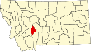
 Расположение в штате Монтана США | |
 Montana's location within the U.S. | |
| Coordinates: 46°20′N 111°30′W / 46.33°N 111.5°W | |
| Country | |
| State | |
| Founded | 1897 |
| Named for | Charles Arthur Broadwater |
| Seat | Townsend |
| Largest city | Townsend |
| Area | |
| • Total | 1,239 sq mi (3,210 km2) |
| • Land | 1,193 sq mi (3,090 km2) |
| • Water | 46 sq mi (120 km2) 3.7% |
| Population (2020) | |
| • Total | 6,774 |
| • Estimate (2022) | 7,793 |
| • Density | 5.5/sq mi (2.1/km2) |
| Time zone | UTC−7 (Mountain) |
| • Summer (DST) | UTC−6 (MDT) |
| Congressional district | 2nd |
| Website | www |
| |
Бродотер округ - это округ в США штате Монтана . По состоянию на переписи 2020 года население составляло 6 774. [ 1 ] Его место округа - Таунсенд . [ 2 ] Округ был назван в честь Чарльза Артура Бродотер , известной железной дороги, недвижимости и банковского магната Монтаны. [ 3 ]
История
[ редактировать ]
Экспедиция Льюиса и Кларка проходила через то, что сейчас является округом Бродотер, когда они проследили реку Миссури . Золото было обнаружено в горах Большого пояса в 1864 году, которые принесли несколько горнодобывающих городов. В 1881 году северная Тихоокеанская железная дорога включала остановку в том, что сейчас является Таунсендом . [ 4 ]
География
[ редактировать ]По данным Бюро переписей Соединенных Штатов , округ имеет общую площадь 1239 квадратных миль (3210 км 2 ), из которых 1193 квадратных миль (3090 км 2 ) земля и 46 квадратных миль (120 км 2 ) (3.7%) is water.[5]
The boundaries of the county are roughly formed by the Big Belt Mountains to the east and north, the Elkhorn Mountains to the west, and the Horseshoe Hills to the south.
Broadwater County is perhaps best known as the home of Canyon Ferry Lake, the third largest body of water in Montana. The lake provides essential irrigation to local farms, and serves as a recreation destination for the region, with fishing, boating, swimming, camping, and wildlife viewing opportunities.[6]
Major highways
[edit]Adjacent counties
[edit]- Meagher County - east
- Gallatin County - south
- Jefferson County - west
- Lewis and Clark County - northwest
National protected area
[edit]- Helena National Forest (part)
Politics
[edit]| Year | Republican | Democratic | Third party(ies) | |||
|---|---|---|---|---|---|---|
| No. | % | No. | % | No. | % | |
| 2020 | 3,173 | 77.45% | 835 | 20.38% | 89 | 2.17% |
| 2016 | 2,348 | 74.94% | 573 | 18.29% | 212 | 6.77% |
| 2012 | 2,152 | 71.47% | 764 | 25.37% | 95 | 3.16% |
| 2008 | 1,875 | 66.80% | 857 | 30.53% | 75 | 2.67% |
| 2004 | 1,778 | 75.47% | 533 | 22.62% | 45 | 1.91% |
| 2000 | 1,488 | 71.75% | 462 | 22.28% | 124 | 5.98% |
| 1996 | 1,029 | 52.34% | 603 | 30.67% | 334 | 16.99% |
| 1992 | 830 | 45.06% | 491 | 26.66% | 521 | 28.28% |
| 1988 | 1,054 | 62.63% | 592 | 35.18% | 37 | 2.20% |
| 1984 | 1,345 | 73.50% | 458 | 25.03% | 27 | 1.48% |
| 1980 | 1,052 | 67.26% | 401 | 25.64% | 111 | 7.10% |
| 1976 | 820 | 59.04% | 557 | 40.10% | 12 | 0.86% |
| 1972 | 916 | 66.57% | 411 | 29.87% | 49 | 3.56% |
| 1968 | 671 | 54.29% | 439 | 35.52% | 126 | 10.19% |
| 1964 | 609 | 50.58% | 595 | 49.42% | 0 | 0.00% |
| 1960 | 680 | 51.87% | 631 | 48.13% | 0 | 0.00% |
| 1956 | 869 | 65.93% | 449 | 34.07% | 0 | 0.00% |
| 1952 | 962 | 68.86% | 435 | 31.14% | 0 | 0.00% |
| 1948 | 704 | 55.61% | 536 | 42.34% | 26 | 2.05% |
| 1944 | 760 | 57.45% | 558 | 42.18% | 5 | 0.38% |
| 1940 | 755 | 46.81% | 854 | 52.94% | 4 | 0.25% |
| 1936 | 502 | 31.43% | 1,071 | 67.06% | 24 | 1.50% |
| 1932 | 512 | 33.71% | 988 | 65.04% | 19 | 1.25% |
| 1928 | 743 | 52.51% | 663 | 46.86% | 9 | 0.64% |
| 1924 | 531 | 37.71% | 486 | 34.52% | 391 | 27.77% |
| 1920 | 723 | 51.50% | 622 | 44.30% | 59 | 4.20% |
| 1916 | 584 | 33.45% | 1,100 | 63.00% | 62 | 3.55% |
| 1912 | 205 | 21.97% | 451 | 48.34% | 277 | 29.69% |
| 1908 | 326 | 37.86% | 495 | 57.49% | 40 | 4.65% |
| 1904 | 392 | 44.90% | 403 | 46.16% | 78 | 8.93% |
Demographics
[edit]| Census | Pop. | Note | %± |
|---|---|---|---|
| 1900 | 2,641 | — | |
| 1910 | 3,491 | 32.2% | |
| 1920 | 3,239 | −7.2% | |
| 1930 | 2,738 | −15.5% | |
| 1940 | 3,451 | 26.0% | |
| 1950 | 2,922 | −15.3% | |
| 1960 | 2,804 | −4.0% | |
| 1970 | 2,526 | −9.9% | |
| 1980 | 3,267 | 29.3% | |
| 1990 | 3,318 | 1.6% | |
| 2000 | 4,385 | 32.2% | |
| 2010 | 5,612 | 28.0% | |
| 2020 | 6,774 | 20.7% | |
| 2022 (est.) | 7,793 | [8] | 15.0% |
| U.S. Decennial Census[9] 1790–1960,[10] 1900–1990,[11] 1990–2000,[12] 2010–2020[1] | |||
2020 census
[edit]As of the 2020 census, there were 6,774 people living in the county.[citation needed]
2010 census
[edit]As of the 2010 census, there were 5,612 people, 2,347 households, and 1,614 families living in the county. The population density was 4.7 inhabitants per square mile (1.8/km2). There were 2,695 housing units at an average density of 2.3 units per square mile (0.89 units/km2). The racial makeup of the county was 96.2% white, 1.3% American Indian, 0.3% black or African American, 0.2% Pacific islander, 0.2% Asian, 0.3% from other races, and 1.5% from two or more races. Those of Hispanic or Latino origin made up 2.2% of the population. In terms of ancestry, 38.7% were German, 16.2% were English, 15.5% were Irish, 7.9% were Norwegian, 6.4% were Scottish, and 2.3% were American.
Of the 2,347 households, 27.5% had children under the age of 18 living with them, 58.7% were married couples living together, 6.2% had a female householder with no husband present, 31.2% were non-families, and 26.6% of all households were made up of individuals. The average household size was 2.37 and the average family size was 2.85. The median age was 45.4 years.
The median income for a household in the county was $44,667 and the median income for a family was $46,949. Males had a median income of $34,500 versus $32,014 for females. The per capita income for the county was $19,606. About 5.8% of families and 10.1% of the population were below the poverty line, including 10.0% of those under age 18 and 7.1% of those age 65 or over.
Economy
[edit]Agriculture is one of the primary industries in Broadwater County. RY Timber and Wheat Montana Bakery were the largest private employers according to the 2000 Census.[6]
Communities
[edit]
City
[edit]- Townsend (county seat)
Census-designated places
[edit]Unincorporated communities
[edit]Former communities
[edit]See also
[edit]- USS Broadwater (APA-139)
- List of lakes in Broadwater County, Montana
- List of mountains in Broadwater County, Montana
- National Register of Historic Places listings in Broadwater County MT
- Yorks Islands
References
[edit]- ^ Jump up to: a b "State & County QuickFacts". United States Census Bureau. Retrieved May 8, 2023.
- ^ "Find a County". National Association of Counties. Archived from the original on May 31, 2011. Retrieved June 7, 2011.
- ^ Merrill, Andrea; Judy Jacobson (1997). Montana almanac. Helena MT: Falcon Publishing. p. 7. ISBN 1-56044-493-2.
- ^ Broadwater County Planning Board (July 2003). "Broadwater County Growth Policy Plan". Archived from the original on August 13, 2011. Retrieved June 1, 2011.
- ^ "2010 Census Gazetteer Files". United States Census Bureau. August 22, 2012. Archived from the original on December 5, 2014. Retrieved November 27, 2014.
- ^ Jump up to: a b State of Montana (2006). "Demographic & economic information for Broadwater County". Internet Archive. Retrieved June 1, 2011.
- ^ Leip, David. "Atlas of US Presidential Elections". uselectionatlas.org. Retrieved April 2, 2018.
- ^ "Annual Estimates of the Resident Population for Counties: April 1, 2020 to July 1, 2022". United States Census Bureau. Retrieved May 8, 2023.
- ^ "U.S. Decennial Census". United States Census Bureau. Retrieved November 27, 2014.
- ^ "Historical Census Browser". University of Virginia Library. Retrieved November 27, 2014.
- ^ "Population of Counties by Decennial Census: 1900 to 1990". United States Census Bureau. Retrieved November 27, 2014.
- ^ "Census 2000 PHC-T-4. Ranking Tables for Counties: 1990 and 2000" (PDF). United States Census Bureau. Archived (PDF) from the original on March 27, 2010. Retrieved November 27, 2014.
- ^ Canton, Broadwater County MT Google Maps (accessed December 31, 2018)
- ^ Copper City, Broadhead County MT Google Maps (accessed December 31, 2018)
- ^ Diamond City, Broadwater County MT Google Maps (по состоянию на 31 декабря 2018 г.)
- ^ Eustis, Broadwater County MT Google Maps (доступ 31 декабря 2018 г.)
- ^ Холкер, округ Broadwater MT Google Maps (по состоянию на 31 декабря 2018 г.)
Внешние ссылки
[ редактировать ]Места рядом с округом Бродвотер, штат Монтана |
|---|
Муниципалитеты и общины округа Бродотер, штат Монтана , США. |
|---|