Jheneigati upazila

Jheneigati
Jhenaigati | |
|---|---|
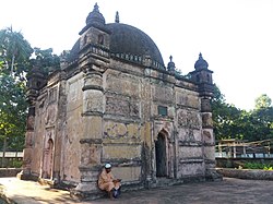 Гагре Хан Бари Масджид, построенный в 1608 году | |
 | |
| Coordinates: 25°11′N 90°4′E / 25.183°N 90.067°E | |
| Country | |
| Division | Mymensingh Division |
| District | Sherpur District |
| Area | |
| • Total | 242.07 km2 (93.46 sq mi) |
| Population (2011) | |
| • Total | 160,452 |
| • Density | 660/km2 (1,700/sq mi) |
| Time zone | UTC+6 (BST) |
| Website | jhenaigati |
Jhenagalal ( Benangal . прошлом Benali) Benangal (Benangal ( (Benangal ( в [ 1 ] Под отделом Mymensingh , Бангладеш .
География
[ редактировать ]Jhenaigati расположен в 25 ° 11′00 ″ с.ш. 90 ° 04′00 ″ E / 25,1833 ° N 90,0667 ° E . У него 30 113 домохозяйств и общая площадь 231 км 2 Полем Упазила ограничена штатом Мегхалая Индия на севере, Шерпур Садар и Шрибарди Упазила на юге, Налирабари Упазила на востоке и Срибарди Упазила на западе. Основные реки - Шомешвари, Махараши и Субарнахали. [ 2 ]
Демография
[ редактировать ]According to the 2011 Bangladesh census, Jhenaigati Upazila had 41,117 households and a population of 160,452. 40,678 (25.35%) were under 10 years of age. Jhenaigati has a literacy rate (age 7 and over) of 38.7%, compared to the national average of 51.8%, and a sex ratio of 1017 females per 1000 males. 5,730 (3.57%) lived in urban areas. Ethnic population is 5931 (3.70%), of which 3,040 are Garo, 1,414 Koch, 659 Barman and 818 others.[3][4]
As of 2001 Bangladesh census, Jhenaigati upazila had a population of 1,60,554; males constituted 78791 of the population, females 76276; Muslim 146,153, Hindu 5,435, Christian 3,388 and others 91.[1]
Administration
[edit]Jhenaigati Thana was formed in 1975 and it was turned into an upazila in 1983.[1]
Jhenaigati Upazila has a Upazila Council and seven union councils: Kangsha, Dhanshail, Nalkura, Gouripur, Jhenaigati Sadar, Hatibandha and Malijhikanda.[5] The union councils are subdivided into 75 mauzas and 117 villages.[6]
U.N.O office, police station, banks, and many NGOs are here. Operationally important NGOs are BRAC, Asa, Grameen Bank, World Vision, SDS, Rangtia Satata Samchay, Rindan Samity and Didar Sangha.
See also
[edit]References
[edit]- ^ Jump up to: a b c Syed Marufuzzaman (2012). "Jhenaigati Upazila". In Islam, Sirajul; Miah, Sajahan; Khanam, Mahfuza; Ahmed, Sabbir (eds.). Banglapedia: the National Encyclopedia of Bangladesh (Online ed.). Dhaka, Bangladesh: Banglapedia Trust, Asiatic Society of Bangladesh. ISBN 984-32-0576-6. OCLC 52727562. OL 30677644M. Retrieved 12 September 2024.
- ^ "ঝিনাইগাতী উপজেলা". www.jhenaigati.sherpur.gov.bd. Retrieved 2021-07-11.
- ^ Jump up to: a b "Community Tables: Sherpur district" (PDF). bbs.gov.bd. 2011.
- ^ "Bangladesh Population and Housing Census 2011 Zila Report – Sherpur" (PDF). bbs.gov.bd. Bangladesh Bureau of Statistics.
- ^ "ইউনিয়ন সমূহ - ঝিনাইগাতী উপজেলা।". http. Archived from the original on 2020-10-31. Retrieved 2021-05-17.
- ^ "District Statistics 2011: Sherpur" (PDF). Bangladesh Bureau of Statistics. Archived from the original (PDF) on 13 November 2014. Retrieved 14 July 2014.
