Мияке-Джима
Родное имя: Миякеджима | |
|---|---|
 | |
 | |
| География | |
| Расположение | Филиппинское море |
| Координаты | 34 ° 04′44 ″ N 139 ° 31′44 ″ E / 34,079 ° N 139,529 ° E |
| Архипелаг | VA Islands |
| Область | 55,44 км 2 (21,41 кв. МИ) |
| Береговая линия | 38,3 км (23,8 миль) |
| Высокая высота | 775,1 м (2543 футов) |
| Самая высокая точка | Ояма |
| Администрация | |
Япония | |
| Префектура | Токио |
| Субпрофектура | Miyake subprefecture |
| Деревня | Мияке |
| Демография | |
| Население | 2,460 (2019) |
| Поп плотность | 44,37/км 2 (114,92/кв. МИ) |
| Этнические группы | Японский |
| Дополнительная информация | |
 | |

Miyake-Jima ( 三宅島 , "Miyake Island") -это вулканический остров на архипелаге Идзу в Филиппинском море, примерно в 180 километрах (110 миль) к юго-востоку от Токио , Япония . [ 1 ] Как и в случае с другими островами в группе острова Идзу, Мияке-Джима является частью национального парка Фудзи-Хаконе-Идзу .
Этимология
[ редактировать ]Есть много теорий о происхождении имени Мияке-Джимы. Одна теория утверждает, что рукопись о происхождении острова под названием «Миякеки» (三宅記) , написанная синтоистским священником с острова, повлияла на название. Рукопись объясняет, как божество, Машима (三嶋), построил свой дворец на острове после того, как построило два других дома на соседних островах. У каждого из домов были спины, обращенные к дворцу, что дало впечатление. Эта вера известна как «теория трех домов». Другая гипотеза говорит о том, что святыни на Мияке-джиме исторически связаны с таковыми на Мияджиме , острове в заливе Хиросима. Поскольку есть еще много спекуляций, истинное происхождение не может быть известно. [ 2 ]

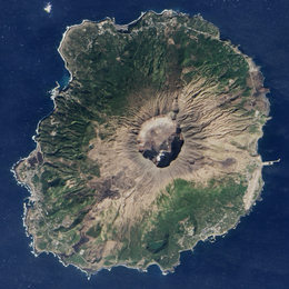
География
[ редактировать ]Остров представляет собой стратоволкано с гранитным композитным конусом, датируемым поздним плейстоценовым периодом, от 10 000 до 2000 лет назад. Остров имеет примерно круглую береговую линию длиной 88,3 километра, со средним диаметром восьми километров. Самая высокая высота гора Ояма ( 雄山 , Oyama-San ) -это активный вулкан с высотой 759 метров. Гора была зарегистрирована, которая разразилась много раз на протяжении всей истории и упоминается в периода Нара письменных записях . За последние 890 лет он разразился 13 раз, в том числе пять раз с начала периода Мэйдзи . Поток лавы в 1940 году убил 11 человек, а другие извержения произошли в 1962 и 1983 годах. [ 3 ]
On July 14, 2000, Mount Oyama began another series of eruptions, and by September, the island was completely evacuated. After a four-year period of volcanic emissions, residents were allowed to return permanently on February 1, 2005. After the eruption, there has been a constant flow of sulfur dioxide gas coming from Mount Oyama. Residents of the island were once required to carry gas masks with them at all times. However, masks have not been needed for years. Alarms go off if there is a dramatic increase in the levels of toxic gases in the air.[4] Volcanic gas emissions from this volcano are measured by a Multi-Component Gas Analyzer System, which detects pre-eruptive degassing of rising magmas, improving prediction of volcanic activity.[5]
|


Climate
[edit]Miyake-jima has a humid subtropical climate (Köppen climate classification Cfa) with very warm summers and mild winters. Precipitation is abundant throughout the year, but is somewhat lower in winter.
| Climate data for Miyake-jima (1991−2020 normals, extremes 1942−present) | |||||||||||||
|---|---|---|---|---|---|---|---|---|---|---|---|---|---|
| Month | Jan | Feb | Mar | Apr | May | Jun | Jul | Aug | Sep | Oct | Nov | Dec | Year |
| Record high °C (°F) | 20.1 (68.2) |
21.8 (71.2) |
22.5 (72.5) |
24.9 (76.8) |
28.1 (82.6) |
31.1 (88.0) |
33.1 (91.6) |
32.8 (91.0) |
32.3 (90.1) |
29.4 (84.9) |
25.7 (78.3) |
23.8 (74.8) |
33.1 (91.6) |
| Mean daily maximum °C (°F) | 12.1 (53.8) |
12.4 (54.3) |
15.0 (59.0) |
18.6 (65.5) |
21.9 (71.4) |
24.2 (75.6) |
27.8 (82.0) |
29.1 (84.4) |
26.7 (80.1) |
22.9 (73.2) |
19.0 (66.2) |
14.6 (58.3) |
20.4 (68.7) |
| Daily mean °C (°F) | 9.9 (49.8) |
10.0 (50.0) |
12.3 (54.1) |
15.8 (60.4) |
19.2 (66.6) |
21.8 (71.2) |
25.3 (77.5) |
26.6 (79.9) |
24.5 (76.1) |
20.8 (69.4) |
16.8 (62.2) |
12.5 (54.5) |
18.0 (64.3) |
| Mean daily minimum °C (°F) | 7.1 (44.8) |
6.9 (44.4) |
9.2 (48.6) |
12.7 (54.9) |
16.2 (61.2) |
19.5 (67.1) |
23.2 (73.8) |
24.3 (75.7) |
22.2 (72.0) |
18.4 (65.1) |
14.1 (57.4) |
9.7 (49.5) |
15.3 (59.5) |
| Record low °C (°F) | −1.2 (29.8) |
−1.4 (29.5) |
−0.2 (31.6) |
2.8 (37.0) |
7.4 (45.3) |
12.1 (53.8) |
14.8 (58.6) |
18.2 (64.8) |
14.1 (57.4) |
8.9 (48.0) |
3.7 (38.7) |
0.9 (33.6) |
−1.4 (29.5) |
| Average precipitation mm (inches) | 150.9 (5.94) |
170.9 (6.73) |
275.6 (10.85) |
229.3 (9.03) |
243.3 (9.58) |
349.7 (13.77) |
240.2 (9.46) |
206.6 (8.13) |
330.9 (13.03) |
418.9 (16.49) |
234.2 (9.22) |
171.1 (6.74) |
3,024.7 (119.08) |
| Average precipitation days (≥ 1.0 mm) | 9.2 | 10.1 | 14.1 | 11.5 | 11.3 | 13.6 | 10.2 | 8.9 | 13.5 | 13.8 | 12.0 | 10.7 | 138.9 |
| Average relative humidity (%) | 65 | 66 | 70 | 73 | 79 | 86 | 87 | 86 | 83 | 78 | 72 | 67 | 76 |
| Mean monthly sunshine hours | 114.8 | 117.9 | 133.5 | 166.7 | 181.8 | 126.8 | 182.8 | 221.9 | 136.0 | 103.9 | 107.2 | 108.7 | 1,693.3 |
| Source: Japan Meteorological Agency[6][7] | |||||||||||||
Graphs are unavailable due to technical issues. There is more info on Phabricator and on MediaWiki.org. |
See or edit raw graph data.
Flora and fauna
[edit]Miyake-jima is home to an unusually rich flora and fauna with several rare species of birds and animals, although its natural habitats are constantly under threat from human and volcanic activity. Underwater, the island is valued by divers for its coral reefs and marine fauna (including the dolphin population outside nearby Mikura-jima). The island has been recognised as an Important Bird Area (IBA) by BirdLife International because it supports populations of Japanese wood pigeons, Japanese murrelets, Pleske's grasshopper warblers, Ijima's leaf-warblers and Izu thrushes (akakokko).[8][9]
Administration
[edit]The island is administered by the Miyake subprefecture of the Tokyo Metropolitan government. As of June 1, 2016, the population of the island was 2451. Miyake Village (三宅村, Miyake-mura) serves as the local government of the island, and also includes nearby tiny uninhabited Ōnoharajima west south-west of Miyake-jima.
Miyake village consists of the five traditional hamlets of Izu, Kamitsuki, Igaya, Ako and Tsubota, with Tsubota on the southeast coast as the administrative center.


Access
[edit]The island is accessible by an over-night ferry called the Tachibana Maru (橘丸), which is operated by Tōkai Kisen. The ferry departs from Takeshiba Pier, near Hamamatsuchō Station, Tokyo at 22:30 and arrives at Miyakejima at 5:00. Depending on the wind and weather conditions, the Tachibana Maru will dock at one of three ports; Miike Port Pier (三池港桟橋), Igaya Port (伊ヶ谷港), or Sabigahama Port (錆ヶ浜港). The port where the boat will dock is not predictable and changes on a daily basis. Generally, the boat will arrive at a port that is complementary with the wind direction. A second large passenger ship named Salvia Maru (さるびあ丸) also started servicing Miyake-jima on June 25, 2020.[10]
There are flights connecting Miyakejima Airport and Haneda Airport with an approximate flying time of 50 minutes. Flights are also operated from Chofu Airport. The area is prone to high volume of sulfuric gas and flights were suspended for almost eight years after the July 14, 2000 volcano eruption. Flights resumed during April 2008, after sulfuric gases in the air dropped to levels below 0.2ppm.[11] There is a helicopter that arrives via Izu Ōshima. There are also two helicopter flights operated by Tokyo Island Shuttle which originate in Aogashima and Izu Ōshima and fly to Toshima, Miyake-jima, Mikura-jima, Hachijō-jima and Aogashima.
|


There are two bus routes on the island. Both bus routes service the same stops, but one route goes clockwise and the other route goes counter-clockwise. The time between each bus stop arrival can vary greatly from a few minutes to up to 3 hours.[12]

See also
[edit]- List of volcanoes in Japan
- List of islands of Japan
- Izu Islands
- Devil's Sea
- Jack Moyer (1929–2004), former resident and marine biologist
- Two Car (2017), an animated television series set in Miyake-jima
References
[edit]- ^ Nussbaum, Louis-Frédéric. (2005). "Izu Shotō," Japan Encyclopedia, p. 412.
- ^ Yamamoto, Hiroko (2008). "Hi no shima no shinwa to saishi: 'Miyake-ki' o yomu (< tokushū > shūkyō o meguru chūsei no gensetsu)" 火の島の神話と祭祀 : 『三宅記』を読む(<特集>宗教をめぐる中世の言説) [Myths and rituals of the Island of Fire: Reading "Miyakeki" (<Special Feature> Medieval Discourses on Religion)]. Japanese Literature (in Japanese). 57 (7). Japan Literary Association: 52–65. doi:10.20620/nihonbungaku.57.7_52 – via JSTAGE (Japan Science and Technology Information Aggregator, Electronic).
- ^ "Mount Oyama, Miyakejima Island, Japan". Archived from the original on 22 February 2005. Retrieved 3 February 2005.
- ^ "International Surf Angling Festival for Miyakejima Island Reconstruction" (PDF). Japan National Tourism Organization. 4 November 2006. Archived from the original (PDF) on 26 June 2011. Retrieved 10 January 2011.
- ^ Liuzzo, M.; Aiuppa, A.; Giudice, G.; Gurrieri, S. (19–24 April 2009). Real-time Multi-GAS sensing of volcanic gas composition: experiences from the permanent Etna and Stromboli networks. EGU General Assembly 2009. Vol. 11. Vienna, Austria. p. 5839. Bibcode:2009EGUGA..11.5839L.
- ^ 観測史上1~10位の値(年間を通じての値). JMA. Retrieved 23 February 2022.
- ^ 気象庁 / 平年値(年・月ごとの値). JMA. Retrieved 23 February 2022.
- ^ "Miyakejima island". BirdLife Data Zone. BirdLife International. 2021. Retrieved 30 January 2021.
- ^ "The Asahi Shimbun | Breaking News, Japan News and Analysis". The Asahi Shimbun. Retrieved 30 June 2023.
- ^ "Tokai Kisen Co., LTD. | Travel and Tours to the Izu Islands".
- ^ "三宅島—羽田間空路、7年8か月ぶり再開 : 社会 : Yomiuri Online(読売新聞)". Archived from the original on 26 April 2008.
- ^ «Расписание на автобусе Мияке (с 1 мая 2018 года» (PDF) . Miyakejima.gr.jp (на японском языке) . Получено 30 июня 2023 года .
- Полный Атлас Японии Тейкоку , Тейкоку-Шойн., ООО Токио 1990, ISBN 4-8071-0004-1
Внешние ссылки
[ редактировать ]- Официальный сайт Miyake Village
- Miyakejima - Японское метеорологическое агентство (на японском языке)
- «Miyakejima: национальный каталог активных вулканов в Японии» (PDF) . - Японское метеорологическое агентство
- Miyake Jima - Геологическая служба Японии
- «Миякеджима» . Глобальная программа вулканизма . Смитсоновский институт . Получено 24 июня 2021 года .