Первоначально Токио был известен как Эдо ( 江戸 ) , кандзи, состоящее из 江 ( e , «бухта, вход») и 戸 ( to , «вход, ворота, дверь»). [ 26 ] Название, которое можно перевести как « устье », указывает на первоначальное расположение поселения на месте слияния реки Сумида и Токийского залива . Во время Реставрации Мэйдзи в 1868 году название города было изменено на Токио ( 東京 , от 東 tō «восток» и 京 kyō «столица») , когда он стал новой столицей империи. [ 27 ] в соответствии с восточноазиатской традицией включения слова «столица» ( 京 ) в название столицы (например, Киото ( 京都 ), Кэйджо ( 京城 ), Пекин ( Beijing ), Нанкин ( 南京 ) и Сицзин ( 西京 ) ) )). [ 26 ] В ранний период Мэйдзи город иногда называли «Токей», альтернативное произношение тех же символов, обозначающих «Токио», что делало его омографом кандзи . В некоторых сохранившихся официальных английских документах используется написание «Токей»; [ 28 ] однако это произношение устарело. [ 29 ]
Первоначально Токио был деревней под названием Эдо , частью старой провинции Мусаси . Эдо был впервые укреплен кланом Эдо в конце двенадцатого века. В 1457 году Ота Докан построил замок Эдо , чтобы защитить регион от клана Тиба . После убийства Докана в 1486 году замок и территория перешли во владение нескольких феодалов. В 1590 году Токугава Иэясу получил регион Канто от Тоётоми Хидэёси и переехал туда из своей исконной земли провинции Микава . Он значительно расширил замок, который, как говорили, был заброшен и разрушен, когда он туда переехал, и управлял регионом оттуда. Когда в 1603 году он стал сёгуном , фактическим правителем страны, вся страна стала управляться из Эдо. Хотя сёгунат Токугава на практике страной правил , Императорский дом Японии по-прежнему оставался правителем де-юре, а титул сёгуна был пожалован Императором в качестве формальности. Императорский дом базировался в Киото с 794 по 1868 год, поэтому Эдо еще не был столицей Японии. [ 30 ]
В период Эдо в городе существовал длительный период мира, известный как Пакс Токугава , и при наличии такого мира сёгунат принял строгую политику изоляции, которая помогла увековечить отсутствие какой-либо серьезной военной угрозы городу. . [ 31 ] Отсутствие разрушений, вызванных войной, позволило Эдо направить большую часть своих ресурсов на восстановление после постоянных пожаров, землетрясений и других разрушительных стихийных бедствий, от которых пострадал город. Эдо превратился в один из крупнейших городов мира, население которого к 18 веку достигло миллиона человек. [ 32 ]
Однако этот длительный период изоляции подошел к концу с прибытием американского коммодора Мэтью К. Перри в 1853 году. Коммодор Перри добился открытия портов Симода и Хакодатэ , что привело к увеличению спроса на новые иностранные товары и, как следствие, к увеличению спроса на новые иностранные товары. резкий рост инфляции. [ 33 ] Социальные волнения усилились после повышения цен и привели к массовым восстаниям и демонстрациям, особенно в форме «разгрома» рисовых предприятий. [ 34 ] Тем временем сторонники Императора воспользовались беспорядками, вызванными массовыми мятевыми демонстрациями, для дальнейшей консолидации власти, что привело к свержению последнего сёгуна Токугава, Ёсинобу , в 1867 году. [ 35 ] Спустя 265 лет Пакс Токугава прекратил свое существование. В мае 1868 года замок Эдо был передан силам поддержки императора после переговоров (Падение Эдо ). Некоторые силы, верные сёгунату, продолжали сражаться, но после их потери в битве при Уэно 4 июля 1868 года весь город перешёл под контроль нового правительства . [ 36 ]
Tokyo citizens trying to squeeze into a crowded tram, c. 1910
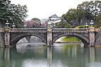
After the overthrow of the Tokugawa shogunate, for the first time in a few centuries, the Emperor ceased to be a mere figurehead and became both the de facto and de jure ruler of the country. Hisoka Maejima advocated for the relocation of the capital functions to Tokyo, recognizing the advantages of the existing infrastructure and the vastness of the Kanto Plain compared to the relatively small Kyoto basin.[37] After being handed over to the Meiji government, Edo was renamed Tokyo (Eastern Capital) on 3 September 1868. Emperor Meiji visited the city once at the end of that year and eventually moved there in 1869. Tokyo had already been the nation's political center for nearly three centuries,[38] and the emperor's residence made it a de facto imperial capital as well, with the former Edo Castle becoming the Imperial Palace.
Government ministries such as the Ministry of Finance were also relocated to Tokyo by 1871,[39] and the first railway line in the country was opened on 14 October 1872, connecting Shimbashi (Shiodome) and Yokohama (Sakuragicho), which is now part of the Tokaido line.[40] The 1870s saw the establishment of other institutions and facilities that now symbolize Tokyo, such as Ueno Park (1873), the University of Tokyo (1877) and the Tokyo Stock Exchange (1878). The rapid modernization of the country was driven from Tokyo, with its business districts such as Marunouchi filled with modern brick buildings and the railway network serving as a means to help the large influx of labour force needed to keep the development of the economy.[41] The City of Tokyo was officially established on May 1, 1889. The Imperial Diet, the national legislature of the country, was established in Tokyo in 1889, and it has ever since been operating in the city.
The Metropolitan Police headquarters on fire following the earthquake. The fire triggered by the earthquake caused fire whirls.
On 1 September 1923, the Great Kanto Earthquake struck the city, and the earthquake and subsequent fire killed an estimated 105,000 citizens. The loss amounted to 37 percent of the country's economic output.[42] On the other hand, the destruction provided an opportunity to reconsider the planning of the city, which had changed its shape hastily after the Meiji Restoration. The high survival rate of concrete buildings promoted the transition from timber and brick architecture to modern, earthquake-proof construction.[43][44] The Tokyo Metro Ginza Line portion between Ueno and Asakusa, the first underground railway line built outside Europe and the American continents, was completed on December 30, 1927.[15]
Although Tokyo recovered robustly from the earthquake and new cultural and liberal political movements, such as Taishō Democracy, spread, the 1930s saw an economic downturn caused by the Great Depression and major political turmoil. Two attempted military coups d'état happened in Tokyo, the May 15 incident in 1932 and the February 26 incident in 1936. This turmoil eventually allowed the military wings of the government to take control of the country, leading to Japan joining the Second World War as an Axis power. Due to the country's political isolation on the international stage caused by its military aggression in China and the increasingly unstable geopolitical situations in Europe, Тоkуо had to give up hosting the 1940 Summer Olympics in 1938.[45]Rationing started in June 1940 as the nation braced itself for another world war, while the 26th Centenary of the Enthronement of Emperor Jimmu celebrations took place on a grand scale to boost morale and increase the sense of national identity in the same year. On 8 December 1941, Japan attacked the American bases at Pearl Harbor in Hawaii, entering the Second World War against the Allied Powers. The wartime regime greatly affected life in the city.[46]
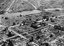
A birds-eye view over the Ningyōchō district after the air raid of 10 March 1945
In 1943, Tokyo City merged with Tokyo Prefecture to form the Tokyo Metropolis (東京都, Tōkyō-to). This reorganization aimed to create a more centralized and efficient administrative structure to better manage resources, urban planning, and civil defence during wartime.[47] The Tokyo Metropolitan Government thus became responsible for both prefectural and city functions while administering cities, towns, and villages in the suburban and rural areas.
Although Japan enjoyed significant success in the initial stages of the war and rapidly expanded its sphere of influence, the Doolittle Raid on 18 April 1942, marked the first direct foreign attack on Tokyo. Although the physical damage was minimal, the raid demonstrated the vulnerability of the Japanese mainland to air attacks and boosted American morale.[48] Large-scale Allied air bombing of cities in the Japanese home islands, including Tokyo, began in late 1944 when the US seized control of the Mariana Islands. From these islands, newly developed long-range B-29 bombers could conduct return journeys. The bombing of Tokyo in 1944 and 1945 is estimated to have killed between 75,000 and 200,000 civilians and left more than half of the city destroyed.[49]
The deadliest night of the war came on March 9–10, 1945, the night of the American "Operation Meetinghouse" raid.[50] Nearly 700,000 incendiary bombs were dropped on the east end of the city (shitamachi, 下町), an area with a high concentration of factories and working-class houses. Two-fifths of the city were completely burned, more than 276,000 buildings were destroyed, 100,000 civilians were killed, and 110,000 more were injured.[51][52] Numerous Edo and Meiji-era buildings of historical significance were destroyed, including the main building of the Imperial Palace, Sensō-ji, Zōjō-ji, Sengaku-ji and Kabuki-za. Between 1940 and 1945, the population of Tokyo dwindled from 6,700,000 to less than 2,800,000, as soldiers were sent to the front and children were evacuated.[53]
The 1964 Olympics in Tokyo symbolized the transition of the city from bombed-out ruins to a modern metropolis.
After the war, Tokyo became the base from which the Allied Occupational Forces, under Douglas MacArthur, an American general, administered Japan for six years. The original rebuilding plan of Tokyo was based on a plan modelled after the Metropolitan Green Belt of London, devised in the 1930s but canceled due to the war.[54] However, due to the monetary contraction policy known as the Dodge Line, named after Joseph Dodge, the neoliberal economic advisor to MacArthur, the plan had to be reduced to a minimal one focusing on transport and other infrastructure. In 1947, the 35 pre-war special wards were reorganized into the current 23 wards. Tokyo did not experience fast economic growth until around 1950, when heavy industry output returned to pre-war levels.[55][54]
Since around the time the Allied occupation of Japan ended in 1952, Tokyo's focus shifted from rebuilding to developing beyond its pre-war stature. From the 1950s onwards, Tokyo's Metro and railway network saw significant expansion, culminating in the launch of the world's first dedicated high-speed railway line, the Shinkansen, between Tokyo and Osaka in 1964. The same year saw the development of other transport infrastructure such as the Shuto Expressway to meet the increased demand brought about by the 1964 Tokyo Olympics, the first Olympic Games held in Asia. Around this time, the 31-metre height restriction, imposed on all buildings since 1920, was relaxed due to the increased demand for office buildings and advancements in earthquake-proof construction.[56] Starting with the Kasumigaseki Building (147 metres) in 1968, skyscrapers began to dominate Tokyo's skyline. During this period of rapid rebuilding, Tokyo celebrated its 500th anniversary in 1956[57] and the Ogasawara Islands, which had been under control of the US since the war ended, were returned in 1968.[58]Ryokichi Minobe, a Marxian economist who served as the governor for 12 years starting in 1967, is remembered for his welfare state policy, including free healthcare for the elderly and financial support for households with children, and his ‘war against pollution’ policy, as well as the large government deficit they caused.[59]
Shinjuku's development as a business district started in the 1970s.
Although the 1973 oil crisis put an end to the rapid post-war recovery and development of Japan's economy, its position as the world's second-largest economy at the time had seemed secure by that point, remaining so until 2010 when it was surpassed by China.[60] Tokyo's development was sustained by its status as the economic, political, and cultural hub of such a country. In 1978, after years of the intense Sanrizuka Struggle, Narita International Airport opened as the new gateway to the city, while the relatively small Haneda Airport switched to primarily domestic flights.[61]West Shinjuku, which had been occupied by the vast Yodobashi Water Purification Centre until 1965, became the site of an entirely new business district characterized by skyscrapers surpassing 200 metres during this period.[62]
The American-led Plaza Accord in 1985, which aimed to depreciate the US dollar, had a devastating effect on Japan's manufacturing sector, particularly affecting small to mid-size companies based in Tokyo.[63] This led the government to adopt a domestic-demand-focused economic policy, ultimately causing an asset price bubble. Land redevelopment projects were planned across the city, and real estate prices skyrocketed. By 1990, the estimated value of the Imperial Palace surpassed that of the entire state of California.[64] The Tokyo Stock Exchange became the largest stock exchange in the world by market capitalization, with the Tokyo-based NTT becoming the most highly valued company globally.[18][65]
The 2020 Olympics were postponed and held in 2021 due to the COVID-19 pandemic.
After the bubble burst in the early 1990s, Japan experienced a prolonged economic downturn called the "Lost Decades", which was charactized by extremely low or negative economic growth, deflation, stagnant asset prices.[66] Tokyo's status as a world city is said to have depreciated greatly during these three decades. Nonetheless, Tokyo still saw new urban developments during this period. Recent projects include Ebisu Garden Place, Tennōzu Isle, Shiodome, Roppongi Hills, Shinagawa, and the Marunouchi side of Tokyo Station. Land reclamation projects in Tokyo have also been going on for centuries. The most prominent is the Odaiba area, now a major shopping and entertainment center. Various plans have been proposed[67] for transferring national government functions from Tokyo to secondary capitals in other regions of Japan, to slow down rapid development in Tokyo and revitalize economically lagging areas of the country. These plans have been controversial[68] within Japan and have yet to be realized.
On September 7, 2013, the IOC selected Tokyo to host the 2020 Summer Olympics. Thus, Tokyo became the first Asian city to host the Olympic Games twice.[69] However, the 2020 Olympic Games were postponed and held from July 23 to August 8, 2021, as a result of the COVID-19 pandemic.[70]
Under Japanese law, the prefecture of Tokyo is designated as a to (都), translated as metropolis.[71] Tokyo Prefecture is the most populous prefecture and the densest, with 6,100 inhabitants per square kilometer (16,000/sq mi); by geographic area it is the third-smallest, above only Osaka and Kagawa. Its administrative structure is similar to that of Japan's other prefectures. The 23 special wards (特別区, tokubetsu-ku), which until 1943 constituted the city of Tokyo, are self-governing municipalities, each having a mayor, a council, and the status of a city.
In addition to these 23 special wards, Tokyo also includes 26 more cities (市-shi), five towns (町-chō or machi), and eight villages (村-son or -mura), each of which has a local government. The Tokyo Metropolitan Government administers the whole metropolis including the 23 special wards and the cities and towns that constitute the prefecture. It is headed by a publicly elected governor and metropolitan assembly. Its headquarters is in Shinjuku Ward.
The governor of Tokyo is elected every four years. The incumbent governor, Yuriko Koike, was elected in 2016, following the resignation of her predecessor, Yoichi Masuzoe. She was re-elected in 2020 and in 2024. The legislature of the Metropolis is called the Metropolitan Assembly, and it has one house with 127 seats. The assembly is responsible for enacting and amending prefectural ordinances, approving the budget (8.5 trillion yen in fiscal 2024),[72] and voting on important administrative appointments made by the governor, including the vice governors. Its members are also elected on a four-year cycle.[73]
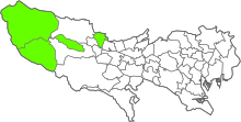
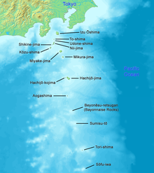
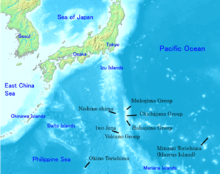
A map with Nishi-Tama District in greenA map of the Izu Islands with black labelsA map of the Ogasawara Islands with black labels
Since the completion of the Great Mergers of Heisei in 2001, Tokyo consists of 62 municipalities: 23 special wards, 26 cities, 5 towns and 8 villages. All municipalities in Japan have a directly elected mayor and a directly elected assembly, each elected on independent four-year cycles. The 23 Special Wards cover the area that had been Tokyo City until 1943, 30 other municipalities are located in the Tama area, and the remeining 9 are on Tokyo's outlying islands.
The special wards (特別区, tokubetsu-ku) of Tokyo comprise the area formerly incorporated as Tokyo City. Each special ward has used the word "city" in their official English name in recent times (e.g. Chiyoda City), but their status is more akin to boroughs in London or New York. Certain municipal functions, such as waterworks, sewerage, and fire-fighting, are handled by the Tokyo Metropolitan Government rather than each ward. To pay for the added administrative costs, the Metropolitan Government collects municipal taxes, which would usually be levied by each ward.[74] The "three central wards" of Tokyo – Chiyoda, Chūō and Minato – are the business core of the city, with a daytime population more than seven times higher than their nighttime population.[75] Chiyoda Ward is occupied by many major Japanese companies and is also the seat of the national government, and the Emperor of Japan, yet is one of the least populated wards.[76]
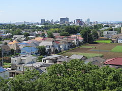
To the west of the special wards, Tokyo Metropolis consists of cities, towns, and villages that enjoy the same legal status as those elsewhere in Japan. While serving as "bed towns" for those working in central Tokyo, some of them also have a local commercial and industrial base, such as Tachikawa. Collectively, these are often known as the Tama area or Western Tokyo. The far west of the Tama area is occupied by the district (gun) of Nishi-Tama. Much of this area is mountainous and unsuitable for urbanization. The highest mountain in Tokyo, Mount Kumotori, is 2,017 m (6,617 ft) high; other mountains in Tokyo include Takanosu (1,737 m (5,699 ft)), Odake (1,266 m (4,154 ft)), and Mitake (929 m (3,048 ft)). Lake Okutama, on the Tama River near Yamanashi Prefecture, is Tokyo's largest lake and serves as the primary reservoir for Tokyo's water supply. The district is composed of three towns (Hinode, Mizuho and Okutama) and one village (Hinohara). The Tokyo Metropolitan Government has designated Hachiōji, Tachikawa, Machida, Ōme and Tama New Town as regional centers of the Tama area.[77]
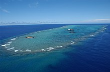
Okinotorishima, 1,740km (1,081mi) away from central Tokyo and the southernmost island of JapanTokyo has numerous outlying islands, which extend as far as 1,850 km (1,150 mi) from central Tokyo. Because of the islands' distance from the administrative headquarters of the Tokyo Metropolitan Government in Shinjuku, local subprefectural branch offices administer them. The Izu Islands are a group of volcanic islands and form part of the Fuji-Hakone-Izu National Park. The islands in order from closest to Tokyo are Izu Ōshima, Toshima, Nii-jima, Shikine-jima, Kōzu-shima, Miyake-jima, Mikurajima, Hachijō-jima, and Aogashima. The Izu Islands are grouped into three subprefectures. Izu Ōshima and Hachijojima are towns. The remaining islands are six villages, with Niijima and Shikinejima forming one village. The Ogasawara Islands include, from north to south, Chichi-jima, Nishinoshima, Haha-jima, Kita Iwo Jima, Iwo Jima, and Minami Iwo Jima. Ogasawara also administers two small outlying islands: Minami Torishima, the easternmost point in Japan and at 1,850 km (1,150 mi) the most distant island from central Tokyo, and Okinotorishima, the southernmost point in Japan.[78] Japan's claim on an exclusive economic zone (EEZ) surrounding Okinotorishima is contested by China and South Korea as they regard Okinotorishima as uninhabitable rocks which have no EEZ.[79] The Iwo chain and the outlying islands have no permanent population, but hosts Japan Self-Defense Forces personnel. Local populations are only found on Chichi-Jima and Haha-Jima. The islands form both Ogasawara Subprefecture and the village of Ogasawara, Tokyo.
This section needs to be updated. Please help update this article to reflect recent events or newly available information.(May 2024)
Tokyo has enacted a measure to cut greenhouse gases. Governor Shintaro Ishihara created Japan's first emissions cap system, aiming to reduce greenhouse gas emission by a total of 25% by 2020 from the 2000 level.[81] Tokyo is an example of an urban heat island, and the phenomenon is especially serious in its special wards.[82][83] According to the Tokyo Metropolitan Government,[84] the annual mean temperature has increased by about 3 °C (5.4 °F) over the past 100 years. Tokyo has been cited as a "convincing example of the relationship between urban growth and climate".[82]
In 2006, Tokyo enacted the "10 Year Project for Green Tokyo" to be realized by 2016. It set a goal of increasing roadside trees in Tokyo to 1 million (from 480,000), and adding 1,000 ha (2,500 acres) of green space, 88 ha (220 acres) of which will be a new park named "Umi no Mori" (Sea Forest) which will be on a reclaimed island in Tokyo Bay which used to be a landfill.[85] From 2007 to 2010, 436 ha (1,080 acres) of the planned 1,000 ha of green space was created and 220,000 trees were planted, bringing the total to 700,000. As of 2014[update], roadside trees in Tokyo have increased to 950,000, and a further 300 ha (740 acres) of green space has been added.[86]
The mainland portion of Tokyo lies northwest of Tokyo Bay and measures about 90 km (56 mi) east to west and 25 km (16 mi) north to south. The average elevation in Tokyo is 40 m (131 ft).[89]Chiba Prefecture borders it to the east, Yamanashi to the west, Kanagawa to the south, and Saitama to the north. Mainland Tokyo is further subdivided into the special wards (occupying the eastern half) and the Tama area (多摩地域) stretching westwards. Tokyo has a latitude of 35.65 (near the 36th parallel north), which makes it more southern than Rome (41.90), Madrid (40.41), New York City (40.71) and Beijing (39.91).[90]
Within the administrative boundaries of Tokyo Metropolis are two island chains in the Pacific Ocean directly south: the Izu Islands, and the Ogasawara Islands, which stretch more than 1,000 km (620 mi) away from the mainland. Because of these islands and the mountainous regions to the west, Tokyo's overall population density figures far under-represent the real figures for the urban and suburban regions of Tokyo.[91]
The former city of Tokyo and the majority of Tokyo prefecture lie in the humid subtropical climate zone (Köppen climate classification: Cfa),[92] with hot, humid summers and mild to cool winters with occasional cold spells. The region, like much of Japan, experiences a one-month seasonal lag. The warmest month is August, which averages 26.9 °C (80.4 °F). The coolest month is January, averaging 5.4 °C (41.7 °F). The record low temperature was −9.2 °C (15.4 °F) on January 13, 1876. The record high was 39.5 °C (103.1 °F) on July 20, 2004.
The record highest low temperature is 30.3 °C (86.5 °F), on August 12, 2013, making Tokyo one of only seven observation sites in Japan that have recorded a low temperature over 30 °C (86.0 °F).[93]
Annual rainfall averages nearly 1,600 millimeters (63.0 in), with a wetter summer and a drier winter. The growing season in Tokyo lasts for about 322 days from around mid-February to early January.[94] Snowfall is sporadic, and occurs almost annually.[95] Tokyo often sees typhoons every year, though few are strong. The wettest month since records began in 1876 was October 2004, with 780 millimeters (30 in) of rain,[96] including 270.5 mm (10.65 in) on the ninth of that month.[97] The most recent of four months on record to observe no precipitation is December 1995.[93] Annual precipitation has ranged from 879.5 mm (34.63 in) in 1984 to 2,229.6 mm (87.78 in) in 1938.[93]
The climates of Tokyo's offshore territories vary significantly from those of the city. The climate of Chichijima in Ogasawara village is on the boundary between the tropical savanna climate (Köppen classification: Aw) and the tropical rainforest climate (Köppen classification: Af). It is approximately 1,000 km (621 mi) south of the Greater Tokyo Area, resulting in much different climatic conditions.
Climate data for Chichijima, Ogasawara, Tokyo, 1991–2020 normals, extremes 1896–present
Tokyo's easternmost territory, the island of Minamitorishima in Ogasawara village, is in the tropical savanna climate zone (Köppen classification: Aw). Tokyo's Izu and Ogasawara islands are affected by an average of 5.4 typhoons a year, compared to 3.1 in mainland Kantō.[109]
Tokyo is near the boundary of three plates, making it an extremely active region for smaller quakes and slippage which frequently affect the urban area with swaying as if in a boat, although epicenters within mainland Tokyo (excluding Tokyo's 2,000 km (1,243 mi)–long island jurisdiction) are quite rare. It is not uncommon in the metro area to have hundreds of these minor quakes (magnitudes 4–6) that can be felt in a single year, something local residents merely brush off but can be a source of anxiety not only for foreign visitors but for Japanese from elsewhere as well. They rarely cause much damage (sometimes a few injuries) as they are either too small or far away as quakes tend to dance around the region. Particularly active are offshore regions and to a lesser extent Chiba and Ibaraki.[110]
Tokyo has been hit by powerful megathrust earthquakes in 1703, 1782, 1812, 1855, 1923, and much more indirectly (with some liquefaction in landfill zones) in 2011;[111][112] the frequency of direct and large quakes is a relative rarity. The 1923 earthquake, with an estimated magnitude of 7.9, killed more than 100,000 people, the last time the urban area was directly hit.[113][114][115]
Mount Fuji has posed the primary volcanic threat to Tokyo's citizens for centuries.
Mount Fuji is about 100 km (62 mi) southwest of Tokyo. There is a low risk of eruption. The last recorded was the Hōei eruption which started on December 16, 1707, and ended about January 1, 1708 (16 days).[116] During the Hōei eruption, the ash amount was 4 cm in southern Tokyo (bay area) and 2 cm to 0.5 cm in central Tokyo.[117]Kanagawa had 16 cm to 8 cm ash and Saitama 0.5 to 0 cm.[117] If the wind blows north-east it could send volcanic ash to Tokyo metropolis.[118] According to the government, less than a millimeter of the volcanic ash from a Mount Fuji eruption could cause power grid problems such as blackouts and stop trains in the Tokyo metropolitan area.[118] A mixture of ash with rain could stick to cellphone antennas, power lines and cause temporary power outages.[118] The affected areas would need to be evacuated.[118]
Tokyo is located on the Kantō Plain with five river systems and dozens of rivers that expand during each season.[119] Important rivers are Edogawa, Nakagawa, Arakawa, Kandagawa, Megurogawa and Tamagawa.[120] In 1947, Typhoon Kathleen struck Tokyo, destroying 31,000 homes and killing 1,100 people.[119] In 1958, Typhoon Ida dropped 400 mm (16 in) of rain in a single week, causing streets to flood.[119] In the 1950s and 1960s, the government invested 6–7% of the national budget on disaster and risk reduction.[119] A huge system of dams, levees and tunnels was constructed.[119] The purpose is to manage heavy rain, typhonic rain, and river floods.[119]
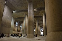
The MAOUDC is the world's largest underground floodwater diversion facility.
Tokyo has currently the world's largest underground floodwater diversion facility called the Metropolitan Area Outer Underground Discharge Channel (MAOUDC).[121][119] It took 13 years to build and was completed in 2006. The MAOUDC is a 6.3 km (3.9 mi) long system of tunnels, 22 meters (72 ft) underground, with 70-meter (230 ft) tall cylindrical tanks, each tank being large enough to fit a space shuttle or the Statue of Liberty.[119] During floods, excess water is collected from rivers and drained to the Edo River.[120] Low-lying areas of Kōtō, Edogawa, Sumida, Katsushika, Taitō and Arakawa near the Arakawa River are most at risk of flooding.[120]
Tokyo's buildings are too diverse to be characterized by any specific archtectural style, but it can be generally said that a majority of extant structures were built in the past a hundred years;[122] twice in recent history has the metropolis been left in ruins: first in the 1923 Great Kantō earthquake and later after extensive firebombing in World War II.[122]
The oldest known extant building in Tokyo is Shofukuji in Higashi-Murayama. The current building was constructed in 1407, during the Muromachi period (1336–1573).[123] Although greatly reduced in number by later fires, earthquakes, and air raids, a considerable number of Edo-era buildings survive to this day. The Tokyo Imperial Palace, which was occupied by the Tokugawa Shogunate as Edo Castle during the Edo Period (1603–1868), has many gates and towers dating from that era, although the main palace buildings and the tenshu tower have been lost.[124]
Numerous temple and shrine buildings in Tokyo date from this era: the Ueno Toshogu still maintains the original 1651 building built by the third shogun Iemitsu Tokugawa.[125] Although partially destroyed during the Second World War, Zojo-ji, which houses the Tokugawa family mausoleum, still has grand Edo-era buildings such as the Sangedatsu gate.[126]Kaneiji has grand 17th-century buildings such as the five-storey pagoda and the Shimizudo. The Nezu Shrine and Gokokuji were built by the fifth shogun Tsunayoshi Tokugawa in the late 1600s. All feudal lords (daimyo) had large Edo houses where they stayed when in Edo; at one point, these houses amounted to half the total area of Edo.[127] None of the grand Edo-era daimyo houses still exist in Tokyo, as their vast land footprint made them easy targets for redevelopment programs for modernization during the Meiji Period. Some gardens were immune from such fates and are today open to the public; Hamarikyu (Kofu Tokugawa family), Shibarikyu (Kishu Tokugawa family), Koishikawa Korakuen (Mito Tokugawa family), Rikugien (Yanagisawa family), and Higo Hosokawa Garden (Hosokawa family). The Akamon, which is now widely seen as a symbol of the University of Tokyo, was originally built to commemorate the marriage of a shogun's daughter into the Maeda clan, one of the most affluent of the feudal lords, while the campus itself occupies their former edo estate.[128]
Edo, 1865 or 1866. Photochrom print. Five albumen prints joined to form a panorama. Photographer: Felice Beato.
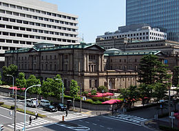
The Meiji era saw a rapid modernization in architectural styles as well; until the Great Kanto Earthquake in 1923 exposed their weakness to seimic shocks, grand brick buildings were constantly built across the city. Tokyo Station (1914), the Ministry of Justice building (1895) and Mistubishi building one (1894, rebuilt in 2010) are some of the few brick survivors from this period. It was regarded as fashionable by some members of the Japanese aristocracy to build their Tokyo residences in grand and modern styles, and some of these buildings still exist, although most are in private hands and open to the public on limited occasions. Aristocratic residences today open to the public include the Marquess Maeda residence in Komaba, the Baron Iwasaki residence in Ikenohata and the Baron Furukawa residence in Nishigahara.
Extant concrete buildings from the interwar period
The 1930s saw the rise of styles that combined characteristics of both traditional Japanese and modern designs. Chuta Ito was a leading figure in this movement, and his extant works in Tokyo include Tsukiji Hongan-ji (1934). The Imperial Crown Style, which often features Japanese-style roofs on top of elevated concrete structures, was adopted for the Tokyo National Museum in Ueno and the Kudan Hall in Kudanminami.[131]
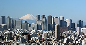
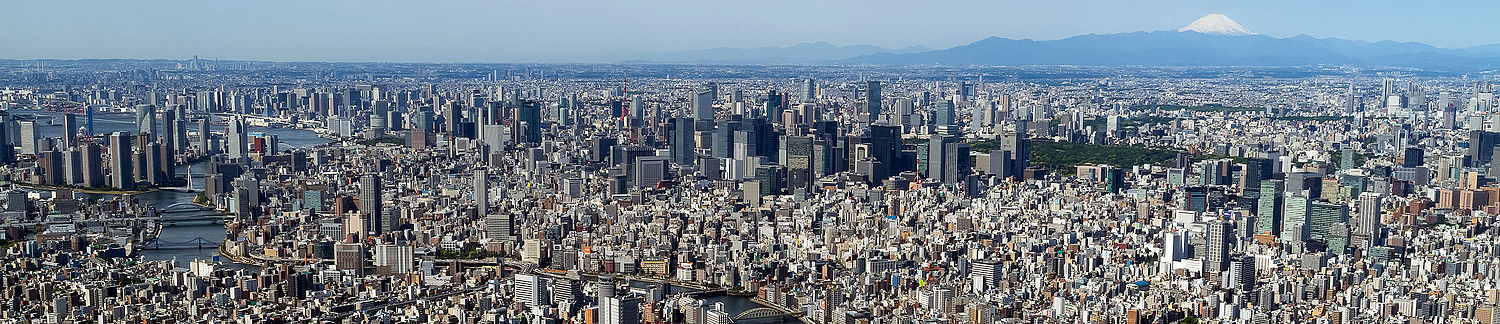
Since the 30-metre height restriction was lifted in the 1960s, Tokyo's most dense areas have been dominated by skyscrapers. As of May 2024, there are at least 184 buildings exceeding 150 metres (492 feet) in Tokyo. Apart from these, Tokyo Tower (333m) and Tokyo Sky Tree (634m) feature high-elevation observation decks; the latter is the tallest tower in both Japan and the world, and the second tallest structure in the world after the Burj Khalifa in Dubai.[14] With a scheduled completion date in 2027, Torch Tower (385m) will overtake Azabudai Hills Mori JP Tower (325.2m) as the tallest building in Tokyo.
As of October 2012, the official intercensal estimate showed 13.506 million people in Tokyo, with 9.214 million living within Tokyo's 23 wards.[132] During the daytime, the population swells by over 2.5 million as workers and students commute from adjacent areas. This effect is even more pronounced in the three central wards of Chiyoda, Chūō, and Minato, whose collective population as of the 2005 National Census was 326,000 at night, but 2.4 million during the day.[133]
Tokyo historical population since 1920
According to April 2024 official estimates, Setagaya (942,003), Nerima (752,608), and Ota (748,081) were the most populous wards and municipalities in Tokyo. The least inhabited of all Tokyo municipalities are remote island villages such as Aogashima (150), Mikurajima (289), and Toshima (306).[134]
In 2021, Tokyo's average and median ages were both 45.5 years old. This is below the national median age of 49.0, placing Tokyo among the youngest regions in Japan. 16.8% of the population was below 15, while 34.6% was above 65.[135] In the same year, the youngest municipalities in Tokyo were Mikura-jima (average age 40.72), Chuo (41.92), and Chiyoda (42.07), while the oldest included Okutama (59.11) and Miyake (53.82).[136]
In 1889, the Home Ministry recorded 1,375,937 people in Tokyo City and a total of 1,694,292 people in Tokyo-fu.[137] In the same year, a total of 779 foreign nationals were recorded as residing in Tokyo. The most common nationality was English (209 residents), followed by American (182) and Chinese nationals (137).[138]
As of January 2024, Tokyo had 647,416 foreign nationals registered as residents, with China, South Korea, Vietnam, the Philippines, Nepal, Taiwan, and the United States each having more than 20,000 nationals living there as citizens.[139] Since the COVID-19 pandemic ended, Tokyo's foreign population has increased significantly, now nearly 20% above the January 2022 population of 546,436.[140] There is no official survey of race or place of birth as of June 2024.
Japanese is the primary language spoken throughout the metropolis, though regional and socio-economic differences can be heard. Traditionally, dialects in Tokyo are classified into two groups: the Yamanote dialect and the Shitamachi dialect. The former has traditionally been spoken in the upper- and upper-middle-class residential area of Yamanote, which includes Bancho, Kojimachi, Koishikawa, Kudan, Yotsuya, Azabu, and Akasaka. During the Edo period, these neighborhoods were occupied by Daimyo and other powerful samurai families, and the dialect evolved largely based on their way of speech. Standard Japanese pronunciation is largely based on this accent and spread across the country with the introduction of radio. The Shitamachi dialect, in contrast, has been associated with the Chōnin district of Shitamachi and retains many characteristics of the accents spoken there in the Edo era.[141] However, socio-economic changes in the post-war period and the large influx of people moving from other areas have largely blurred these distinctions in recent years. It has been reported that young generations are not as aware of the differences in dialects as their parents' and grandparents' generations were.[142]
Marunouchi, the main business districtSector Breakdown of 2021 GDP of Tokyo
Tokyo's gross regional product was 113.7 trillion yen or US$1.04 trillion in FY2021 and accounted for 20.7% of the country's total economic output, which converts to 8.07 million yen or US$73,820 per capita.[16] By sector, Wholesale and Retail was the largest contributor, accounting for 21.5% of the total output. This was followed by Real Estate (13.5%), Professional, Scientific and Technical (12.2%), Information and Communications (11.7%), Finance and Insurance (7.6%), Manufacturing (7.0%), and Healthcare (6.7%). Agriculture, Forestry and Fishery, and Mining combined accounted for less than 0.1% of the economic output.[147] As these numbers suggest, Tokyo's economy is heavily dependent on the tertiary sector. As the Greater Tokyo Area, it has the second-largest metropolitan economy in the world, after Greater New York, with a gross metropolitan product estimated at US$2 trillion. The area's economy is slightly smaller than Canada's economy while being slightly larger than Mexico's, according to IMF estimates from the same year.[148]
In 2023, 29 of the Fortune Global 500 companies were headquartered in Tokyo, which was the second highest concentration in the world after Beijing.[150] Notably, around 20 of them are based in Marunouchi, such as MUFG, Mitsubish Corp. and Hitachi.[151] Tokyo was rated by the Economist Intelligence Unit as the most expensive (highest cost-of-living) city in the world for 14 years in a row ending in 2006, when it was replaced by Oslo, and later Paris.[152][153] However, years of deflation and an extremely weak yen starting in 2022 due to Japan's low interest rates made the cost of living in Tokyo 31% cheaper than in New York City in 2023, which is roughly the same as in Beijing and Manchester according to the 2023 EIU rankings.[154]Henley & Partners estimated that there were 298,300 individuals with a net worth of more than US$1 million living in Tokyo in 2024, the third highest number in the world.[155]
Tokyo is a major international finance center;[156] it houses the headquarters of several of the world's largest investment banks and insurance companies, and serves as a hub for Japan's transportation, publishing, electronics and broadcasting industries. During the centralized growth of Japan's economy following World War II, many large firms moved their headquarters from cities such as Osaka (the historical commercial capital) to Tokyo, in an attempt to take advantage of better access to the government.
The Japanese financial market opened up slowly in 1984 and accelerated its internationalization with the "Japanese Big Bang" in 1998.[159] Despite the emergence of Singapore and Hong Kong as competing financial centers, the Tokyo IFC manages to keep a prominent position in Asia. The Tokyo Stock Exchange is Japan's largest stock exchange, and third largest in the world by market capitalization and fourth largest by share turnover. In 1990 at the end of the Japanese asset price bubble, it accounted for more than 60% of the world stock market value.[160]
Dentsu, Hakuhodo, and ADK Holdings, all based in Tokyo, are the country's largest advertising agencies. All three major telecommunications companies in Japan, namely NTT (whose market capitalization was once the largest among all publicly traded companies in the world),[65]KDDI, and SoftBank, are based in Tokyo. Tokyo is also a major hub for anime production, with major anime studios such as Studio Ghibli, Gainax, Madhouse, A-1 Pictures, MAPPA, Wit Studio, Toei, and Shaft based particularly in the west of the metropolis.
In 2019, tourism accounted for slightly more than one percent of Tokyo's total economic output, with 15.18 million foreign visitors spending 1.26 trillion yen, according to the Tokyo Metropolitan Government.[162]
According to a 2022 government survey, the most visited areas in Tokyo were:[163]
The Toyosu Market in Tokyo is the largest wholesale fish and seafood market in the world since it opened on October 11, 2018.[165] It is also one of the largest wholesale food markets of any kind. It is located in the Toyosu area of Kōtō ward. The Toyosu Market holds strong to the traditions of its predecessor, the Tsukiji Fish Market and Nihonbashi fish market, and serves some 50,000 buyers and sellers every day. Retailers, whole-sellers, auctioneers, and public citizens alike frequent the market, creating a unique microcosm of organized chaos that still continues to fuel the city and its food supply after over four centuries.[166]
Tokyo had 8,460 hectares (20,900 acres) of agricultural land as of 2003,[167] according to the Ministry of Agriculture, Forestry and Fisheries, placing it last among the nation's prefectures. The farmland is concentrated in Western Tokyo. Perishables such as vegetables, fruits, and flowers can be conveniently shipped to the markets in the eastern part of the prefecture.
With 36% of its area covered by forest, Tokyo has extensive growths of cryptomeria and Japanese cypress, especially in the mountainous western communities of Akiruno, Ōme, Okutama, Hachiōji, Hinode, and Hinohara. Decreases in the price of timber, increases in the cost of production, and advancing old age among the forestry population have resulted in a decline in Tokyo's output. In addition, pollen, especially from cryptomeria, is a major allergen for the nearby population centers. Tokyo Bay was once a major source of fish. Most of Tokyo's fish production comes from the outer islands, such as Izu Ōshima and Hachijō-Jima. Skipjack tuna, nori, and aji are among the ocean products.[168]
Tokyo, which is the center of the Greater Tokyo Area, is Japan's largest domestic and international hub for rail and ground transportation. Public transportation within Tokyo is dominated by an extensive network of "clean and efficient"[169] trains and subways run by a variety of operators, with buses, monorails and trams playing a secondary feeder role. There are up to 62 electric train lines and more than 900 train stations in Tokyo.[170]Shibuya Crossing is the "world's busiest pedestrian crossing", with around 3,000 people crossing at a time.[171][172][173]
JR East operates the largest commuter train network in Tokyo as well as intercity services.
The Shinkansen connects major cities around the country to Tokyo.
Rail is the primary mode of transportation in Tokyo,[174] which has the most extensive urban railway network in the world and an equally extensive network of surface lines. JR East operates Tokyo's largest railway network, including the Yamanote Line loop that circles central Tokyo. It operates rail lines throughout the entire metropolitan area of Tokyo and the rest of northeastern Honshu. JR East is also responsible for the Shinkansen high-speed rail lines that link Tokyo and Northeastern cities of Japan (Joetsu Shinkansen, Tohoku/Hokkaido Shinkansen, Yamagata Shinkansen, Akita Shinkansen, Hokuriku Shinkansen).[175] The Tokaido Shinkansen, which links Tokyo and Osaka via Nagoya and Kyoto, as well as western cities beyond, is operated by JR Central. The Chuo Shinkansen, the first-ever long-distance high-speed floating maglev line currently under construction, will also be operated by JR Central. Both JR companies were created from the privatization of Japan National Railways in 1987. JR Freight does not own any part of the railway network but operates freight trains on the JR network.
Two different entities operate Tokyo's underground railway network: the privatized Tokyo Metro, which operates Tokyo Metro lines, and the governmental Tokyo Metropolitan Bureau of Transportation, which operates Toei lines. Tokyo Metro is entirely owned by the Japanese Government and the Tokyo Metropolitan Government since it was privatized in 2004 (it was previously a public entity called the Imperial Capital Rapid Transit Authority from 1941 to 2004), but it is scheduled to go public in 2024.[176] Other major railway operators in Tokyo include Odakyu, Tokyu, Keio, Seibu, Tobu, and Keisei. Although each operator directly owns its railway lines, through services that travel across different lines owned by different operators are common.
Tokyo once had an extensive tram network, with a total distance of 213 km (Tokyo Toden). However, similar to other major cities worldwide, the age of motorization since the 1950s made it considered unfit to share busy roads with cars. Today, only one line, the Arakawa line, remains.[177]
Tokyo has the lowest car ownership rate among all prefectures in Japan, with 0.416 cars per household compared to the national average of 1.025 per household. This is despite Tokyo being one of the most affluent areas in the country, with a nominal GDP per capita of around US$75,000.[178] A 2021 survey found that 81% of respondents without a car were satisfied with public transport and saw no need to own one.[179]
Each road in Tokyo falls into one of the following categories depending on the type of ownership: private roads, municipal roads, metropolitan roads and expressways. As of April 1, 2022, the total length of roads in Tokyo is approximately 24,741 km (including 2,370 km of metropolitan roads), with a total area of approximately 190.31 km2 (including 46.30 km2 of metropolitan roads).[180]
Intercity expressways in and around Tokyo are managed by NEXCO East, while expressways that serve only within the Greater Tokyo Area (Shuto Expressway) are operated by the Metropolitan Expressway Company. Tolls are collected based on the distance travelled. The total length of the Shuto Expressway is 337.8 km, with speed limits usually set at 80 km/h or 60 km/h to reduce noise pollution and accommodate the relatively winding road shapes.[181]
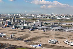
The mainland portion of Tokyo is served by two international airports: Haneda Airport in Ōta and Narita International Airport in neighboring Chiba Prefecture. Haneda has served as the primary airport for Tokyo since 1931. However, the Jet Age saw an exponential increase in flights, prompting the government to build a second airport. Narita was chosen as the site for this second airport in 1966, but local farmers and left-wing activists who sympathized with them protested vehemently for more than a decade (the Sanrizuka Struggle), delaying the new airport's opening until 1978. Almost all international flights were transferred to Narita Airport upon its completion, and Haneda became primarily a domestic airport.[182]
The situation changed when it was decided to expand Haneda Airport and build new runways in 2001. The new runway, Runway D, was constructed partly as a pier-like structure rather than a landfilled structure to avoid obstructing the flow of water in the bay.[183] Its opening in 2010 marked the return of international flights to Haneda, which is much closer to central Tokyo. In 2023, Haneda handled 17.9 million international passengers and 60.8 million domestic passengers,[184] while Narita was used by 25.4 million international passengers and 7.7 million domestic passengers.[185] According to a 2023 survey, Haneda is the fifth busiest airport in the world by passenger traffic.
Water transport is the primary means of importing and exporting goods as well as connecting the Tokyo Islands to the mainland. According to Lloyd's List, the Port of Tokyo handled 4,430,000 TEU of containers in 2022, making it the 46th largest port in the world.[186] The Greater Tokyo Area is served by other major ports such as the Port of Yokohama and the Port of Chiba as well.
Takeshiba Pier (竹芝埠頭) in Minato is used by Tōkai Kisen, which serves islands such as Izu Ōshima, Miyakejima, Hachijojima, Kozushima,[187] and Ogasawara Kaiun, which serves the Ogasawara Islands.[188] Many of these islands are accessible only by ocean routes and helicopters, as they are too small or undulating for a landing ground, making these ships the primary means of inter-island transport. There are ferry routes that connect landmarks within the mainland portion of Tokyo as well; the Tokyo Cruise Ship and the Tokyo Mizube Line operate several routes between tourist attractions such as Asakusa, Hamarikyu, Odaiba, and Shinagawa Aquarium.[189] The Symphony Cruise operates two large restaurant ships that can also be hired as party venues.[190]
Tokyo is the educational, academic, and cultural hub of Japan. From primary to tertiary levels, numerous educational institutions operate in the city to cater to a diverse range of pupils and students.
Tokyo is the heartland of tertiary education in the country, home to 143 authorized universities in 2020.[191] This number includes the nation's most prestigious and selective universities, such as, the University of Tokyo (QS National:1st), Tokyo Institute of Technology (4th), Hitotsubashi University (15th), Waseda University (9th), and Keio University (10th).[192] Additionally, Tokyo University of the Arts is widely regarded as the most prestigious painting, sculpture, crafts, and music school in the country.[193] The United Nations University, which is the academic arm of the United Nations, is headquartered in Shibuya, Tokyo. In 2024, QS Best Student Cities ranked Tokyo as the second-best city for university students, after London.[194] The ranking noted that Tokyo is ideal for 'those who favour total immersion in local culture rather than living in a “student bubble”', stating that despite having high-ranking universities and large global companies offering internships as well as rich culture, Tokyo still has a very low international student population ratio.[195]
At the secondary level, 429 senior high schools are located in Tokyo, six of which are national, 186 are public, and 237 are private.[196] Some senior high schools, often prestigious national or private ones, run jointly with their affiliated junior high schools, providing six-year educational programs (Chūkō Ikkan Kyōiku). The Kaisei Academy,[197]Komaba Junior & Senior High School, University of Tsukuba,[198]Azabu High School, and Oin Junior and Senior High School,[199] the largest sources of successful applicants to the nation's top university, the University of Tokyo,[200] are some examples of such. At the primary level, there are 1332 elementary schools in Tokyo. Six of them are national, 1261 are public, and 53 are private.[196]
Early-modern-established academies such as Gakushuin and Keio provide all-through educational programs from primary schools to universities, originally to cater to the needs of traditionally affluent and powerful families.[201] There are international and ethnic schools that abide by the national curricula of their respective countries or international curricula rather than the Japanese one as well, such as the British School in Tokyo, Tokyo Chinese School, the American School in Japan, and the Tokyo International School.
Almost all major Japanese learned societies are based in Tokyo. The Japan Academy, the country's academy of sciences, was established in 1879 to bring together leading scholars in various disciplines.[202] The Japan Art Academy was established in 1919 with a similar purpose.[203] These two national academies are headquartered in Ueno Park. The newest national academy, the Science Council of Japan, was established in 1949 with the purpose of promoting scientific research and the application of research findings to civilian life. It is located in Roppongi, Minato.
The nightlife district of Tokyo is centred around areas in the west of the city such as Shibuya, Shinjuku, and Roppongi, with high a concentration of bars, clubs, host and hostess clubs, and live music venues.[210] Tokyo is also known for its festivals, such as the Sannō Matsuri at Hie Shrine, the Sanja Festival at Asakusa Shrine, and the biennial Kanda Matsuri, which features parades with elaborately decorated floats. Harajuku, located in Shibuya, is internationally famous for its youth fashion and street culture, with trendy shops, cafes, and Takeshita Street.[211]Akihabara, known as “Electric Town”, is a hub for electronics and otaku culture such as anime and computer games, with numerous shops selling anime, manga, and gaming merchandise.[212]Ginza and Nihombashi are two of Tokyo's most notable shopping districts. Ginza is known for its high-end shopping, featuring luxury brand stores, boutique shops, and department stores such as Mitsukoshi and Wako. It is also home to numerous fine dining places and art galleries, making it a cultural and commercial hub. Nihombashi, historically a centre of commerce, has long-established shops and the Mitsukoshi department flagship store, Japan's first department store, founded in 1673.[213]Jinbōchō is known for its concentration of bookstores, publishing houses, and literary cafes, and its links to a large number of famous literary figures.[214]
Modern attractions in Tokyo include the Tokyo Skytree in Sumida, the tallest structure in Japan, which provides panoramic views of the city from its observation decks. Odaiba, a man-made island in Tokyo Bay, features shopping, dining and entertainment attractions such as the teamLab Planets digital art museum and Joypolis indoor amusement park.[215] The Tokyo Disney Resort and its two theme parks Tokyo Disneyland and Tokyo DisneySea are major destinations for family entertainment. Although these Disney theme parks bear the name Tokyo, they are in fact located in nearby Urayasu, Chiba, just east of Tokyo.
In November 2007, Michelin released their first guide for fine dining in Tokyo, awarding 191 stars in total, or about twice as many as Tokyo's nearest competitor, Paris. As of 2017, 227 restaurants in Tokyo have been awarded (92 in Paris). Twelve establishments were awarded the maximum of three stars (Paris has 10), 54 received two stars, and 161 earned one star.[216]
Токио принимал летние Олимпийские игры 1964 года , став, таким образом, первым азиатским городом, принявшим летние игры . Национальный стадион, также известный как Олимпийский стадион , принимал ряд международных спортивных мероприятий. В 2016 году его должен был заменить Новый национальный стадион . Благодаря множеству спортивных площадок мирового класса, Токио часто проводит национальные и международные спортивные мероприятия, такие как баскетбольные турниры, женские турниры по волейболу, теннисные турниры, соревнования по плаванию, марафоны, игры по регби и регби-семерки, показательные футбольные игры, дзюдо и каратэ. . Токийская столичная гимназия в Сендагае , Сибуя , представляет собой большой спортивный комплекс, включающий в себя бассейны, тренировочные залы и большую крытую арену. По данным «Вокруг колец» , гимназия принимала чемпионат мира по спортивной гимнастике в октябре 2011 года, несмотря на первоначальные сомнения Международной федерации гимнастики в способности Токио принять чемпионат после тройной катастрофы, обрушившейся на Японию. [ 224 ] Токио также был выбран для проведения ряда игр чемпионата мира по регби 2019 года , а также для проведения летних Олимпийских и Паралимпийских игр 2020 года , которые пришлось перенести на лето 2021 года из-за пандемии COVID-19 .
^ Jump up to: а б «Токио – GoJapanGo» . Достопримечательности Токио – японский образ жизни . Mi Marketing Pty Ltd. Архивировано из оригинала 26 апреля 2012 года . Проверено 18 апреля 2012 г.
^ Иглесиас, Фернандо и Исоя Синдзи. «Первый глобальный план управления реструктуризацией городского ландшафта в Токио». Журнал Корейского института ландшафтной архитектуры, международное издание 1 (2001): 176–182.
^ Михут, Мариус Иоан. «Plazza Acord и «взрыв» японских прямых иностранных инвестиций». Procedia Economics and Finance 15 (2014): 721-729.
↑ Буквально 東/Хигаси- означает Восток; но когда город Ямато был переименован в город Хигаси-Ямато в 1970 году, 東 должен был обозначать 東/То- в Токио, см. Город Хигаси-Ямато: названия города «Хигаси Ямато». 9 Архив июля 2021 г., в Wayback Machine (японский: по названию города «Хигаси-Ямато»), получено 6 июля 2021 г.
^ Масато Ояма (март 2007 г.). 1707 г. Извержение . Комплексное объяснение исторических извержений горы Фудзи (База данных извержений и других видов деятельности вулкана Фудзи, Япония, основанная на исторических записях с 781 года нашей эры) (на японском языке). Университет Сидзуока. Архивировано из оригинала 12 августа 2017 года . Проверено 25 сентября 2008 г.
^ «Бывший замок Эдо» . Национальный институт экологических исследований и обучения (NGP) . Архивировано из оригинала 21 июня 2024 года . Проверено 21 июня 2024 г.
^ » «Веб-сайт Уэно Тосёгу . Официальная домашняя страница Уэно Тосёгу . Архивировано из оригинала 14 февраля 2021 года . Проверено 21 июня 2024 года .
^ «Махонзан Зодзёдзи» Архивировано www.zojoji.or.jp (на японском языке). из оригинала 21 июня 2024 года . Проверено 21 июня 2024 года .
^ Масаеси Сибатани, 1990. Языки Японии , стр. 207.
^ Томас Пеллард. Сравнительное изучение японских языков. Подходы к исчезающим языкам в Японии и Северо-Восточной Азии: описание, документация и возрождение , Национальный институт японского языка и лингвистики, август 2018 г., Тачикава, Япония. ffhal-01856152
^ Группа статистики садоводства, Отдел статистики производства, Департамент статистики и информации Министерства сельского, лесного и рыбного хозяйства (15 июля 2003 г.). «Статистика посевных площадей» (PDF) . Архивировано из оригинала (PDF) 24 июня 2008 г. Проверено 18 октября 2008 г.
^ Бюро Токийского конгресса и посетителей. «Ночная жизнь Токио» . Официальный путеводитель по Токио, GO TOKYO . Архивировано из оригинала 31 мая 2024 года . Проверено 31 мая 2024 г. {{cite web}}: |last= имеет общее имя ( справка )
^ Бюро Токийского конгресса и посетителей. «Такешита-стрит» . Официальный путеводитель по Токио, GO TOKYO . Архивировано из оригинала 31 мая 2024 года . Проверено 31 мая 2024 г. {{cite web}}: |last= имеет общее имя ( справка )
^ Бюро Токийского конгресса и посетителей. «Хаппо-ен» . Официальный путеводитель по Токио, GO TOKYO . Архивировано из оригинала 31 мая 2024 года . Проверено 31 мая 2024 г. {{cite web}}: |last= имеет общее имя ( справка )
Фьеве, Николя и Пол Уэйли. (2003). Японские столицы в исторической перспективе: место, сила и память в Киото, Эдо и Токио . Лондон: RoutledgeCurzon. ISBN 978-0-7007-1409-4 ; ОСЛК 51527561
Макклейн, Джеймс, Джон М. Мерриман и Каору Угава. (1994). Эдо и Париж: городская жизнь и государство в эпоху раннего Нового времени . Итака: Издательство Корнельского университета. ISBN 978-0-8014-2987-3 ; ОСЛК 30157716
Соренсен, Андре. (2002). Создание городов Японии: города и планирование от Эдо до XXI века . Лондон: RoutledgeCurzon. ISBN 978-0-415-22651-6 ; ОСЛК 48517502
Джонс, Суми и др. ред. Токийская антология: литература современного мегаполиса Японии, 1850–1920 (2017); из первоисточников отрывок
Перес, Луи Г. Токио: география, история и культура (ABC-CLIO, 2019).
Рейнольдс, Джонатан М. «Здание императорского парламента Японии: дебаты по поводу построения национальной идентичности». Художественный журнал . 55 № 3 (1996) стр. 38+.
Уэйли, Пол. «Токио как мировой город: переоценка роли капитала и государства в городской реструктуризации». Городские исследования 2007 44 (8): 1465–1490. ISSN 0042-0980 Полный текст: Эбско
Arc.Ask3.Ru Номер скриншота №: eb41f9bbb24023aa3284c0597daad78d__1723712160 URL1:https://arc.ask3.ru/arc/aa/eb/8d/eb41f9bbb24023aa3284c0597daad78d.html Заголовок, (Title) документа по адресу, URL1: Tokyo - Wikipedia
Данный printscreen веб страницы (снимок веб страницы, скриншот веб страницы), визуально-программная копия документа расположенного по адресу URL1 и сохраненная в файл, имеет: квалифицированную, усовершенствованную (подтверждены: метки времени, валидность сертификата), открепленную ЭЦП (приложена к данному файлу), что может быть использовано для подтверждения содержания и факта существования документа в этот момент времени. Права на данный скриншот принадлежат администрации Ask3.ru, использование в качестве доказательства только с письменного разрешения правообладателя скриншота. Администрация Ask3.ru не несет ответственности за информацию размещенную на данном скриншоте. Права на прочие зарегистрированные элементы любого права, изображенные на снимках принадлежат их владельцам. Качество перевода предоставляется как есть. Любые претензии, иски не могут быть предъявлены. Если вы не согласны с любым пунктом перечисленным выше, вы не можете использовать данный сайт и информация размещенную на нем (сайте/странице), немедленно покиньте данный сайт. В случае нарушения любого пункта перечисленного выше, штраф 55! (Пятьдесят пять факториал, Денежную единицу (имеющую самостоятельную стоимость) можете выбрать самостоятельно, выплаичвается товарами в течение 7 дней с момента нарушения.)


 Tama
Tama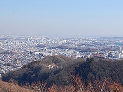


 Определения из Викисловаря
  СМИ из Commons
  Новости из Викиновостей
  Учебники из Wikibooks
  Туристическая информация от Wikivoyage