Пик

| Пик | |
|---|---|
 | |
| Самая высокая точка | |
| Возвышение | 2829 м (9 281 фут) [ 1 ] [ 2 ] |
| Известность | 2829 м (9 281 фут) Занимает 120 -е место |
| Список | Страна высокая точка Ультра Список гор в Кейп -Верде |
| Координаты | 14 ° 57′00 ″ с.ш. 24 ° 20OUS30 ″ W / 14,95000 ° N 24,34167 ° W [ 1 ] |
| Geography | |
 Pico de Fogo | |
| Geology | |
| Mountain type | Sommian-Stratovolcano |
| Last eruption | November 2014 to February 2015 |
Пик огня ( Португальский: [ˈpiku du ˈfoɡu] ; зажженная « Пик огня » ) является активным стратоволкано, расположенным на острове Фого , Кейп -Верде , поднимаясь до 2829 метров (9 281 фута) над уровнем моря . [ 2 ] Основной конус в последний раз разразился в 1680 году, вызывая массовую эмиграцию с острова. [ 3 ] В 1995 году вспыхнуло дочернее вентиляционное отверстие . Единственное смертельное извержение было в 1847 году, когда землетрясения убили несколько человек.
Фого, который означает «огонь» на португальском языке, является вулканическим островом горячей точки . [ 4 ] Его последние извержения произошли в 1951, 1995 и 2014 годах. Это самый молодой и наиболее активный вулкан на островах Кейп -Верде, короткой цепи вулканических островов, которая, как правило, моложе в западной части, когда африканская пластина двинулась на восток над горячей точкой. [ 5 ]
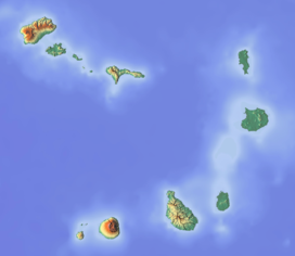
Фого состоит из одного вулкана, поэтому остров почти круглый и около 25 километров (16 миль) в диаметре. [ 6 ] Большая вершина Caldera (около 10 километров в направлении север -юг и 7 километров в направлении востока -запад) находится не в центре острова, а скорее к его северо -восточному углу. Кальдера ограничена крутыми почти вертикальными разломами на севере, западной и южной сторонах, но нарушается на востоке, где лава может течь на побережье. [7] North-northeast-trending eruptive fissures opened along the western flank of Pico, which formed inside the caldera between about 1500 and 1760.[5] The last eruption from the top was in 1769. The current topography of Fogo, with the caldera open to the sea on the east side, results from the sliding of the east flank of the volcano towards the ocean.[5]
The mountain's slopes are used to grow coffee, while its lava is used as building material.[citation needed] Near its peak is a caldera and a small village, Chã das Caldeiras, is inside this caldera. The crater rim, which reaches 2,700 m elevation, is known as Bordeira.
73,000 years ago
[edit]The eastern side of Fogo collapsed into the ocean 73,000 years ago, creating a tsunami 170 meters high which struck the nearby island of Santiago.[8] The tsunami was dated by isotope analysis of boulders deposited on Santiago.
1680 AD eruption
[edit]In 1680 AD, a major summit eruption of Pico do Fogo produced large ash falls over the whole island rendering agricultural lands temporarily unusable and triggering mass emigration from the island, to the neighboring island of Brava in particular.[3]
1995 eruption
[edit]The 1995 eruption began on the night of 2–3 April, covering the island with a cloud of ash.[5] Residents were evacuated from Chã das Caldeiras, as their homes were destroyed.[9]

Residents reported that the eruption was preceded by small earthquakes which began about six days prior to the first eruption of lava. These earthquakes increased in magnitude and frequency through April 2, and a particularly strong one was reported at about 8 p.m., four hours before the eruption apparently began. Just after midnight, fissures opened on the flank of Pico. One resident said it looked as if the cone had "been cut by a knife." The eruption began with Strombolian activity, quickly followed by a 'curtain-of-fire' lava fountain that fed a flow which cut off the road to the village of Portela by 2 a.m. The 1,300 people living inside the caldera fled during the night to the safety of villages on the north coast. No one was killed, but about 20 people required medical attention.[5]
During the day on April 3, the island was engulfed by a thick cloud of dark ash that reached 2.5 to 5 kilometers high. The initial flows were pahoehoe lava, although their extent was apparently small. The violent eruption produced lava bombs up to 4 meters across that were ejected as far as 500 meters from the vents. On April 4, lava fountains reached 400 meters high beneath a cloud of ash about 2 kilometers high. A new scoria cone formed that was open to the southwest and fed a growing lava flow. On April 5, the new lava flow reached the western caldera wall and destroyed about five houses and the main water reservoir. During these first few days, civil authorities evacuated about 3,000 people.[5]

The eruption became steadier after the first few days, and moderate, Hawaiian-style lava fountains about 100–120 meters high built a spatter cone more than 140 meters high. The flows were lava, and flowed towards the west to the caldera wall, then turned north. These flows advanced episodically as pressure built from ponding and thickening of the flows. On April 13, a second lava flow began to cover an earlier, stagnant lava flow, and was almost entirely on top of the earlier flow until April 15, when it spread out and destroyed another home. Cinder fell as far as two kilometers south of the vents on April 15. By the 17th, the flow had advanced to within 420 meters of the nearest house in the village of Portela.[5]
On April 18, a portable seismometer began to record much stronger volcanic tremors that indicated a change in eruptive style from lava fountains back to Strombolian activity. Spatter was discharged every 3–8 seconds with loud gas bursts. In addition, the eruptive rate increased and the upper 300 meters of the channel was largely pahoehoe lava. The eruption rates, estimated from the dimensions and flow rates in the channel, were between 4 and 8.5 million cubic meters per day.[5]
During the night of April 18, a series of large, explosive bursts occurred that may have followed collapse of parts of the cone into the vents and subsequent explosive clearing of the debris. By morning, the activity had returned to lava fountaining, and the seismic record was much quieter. The lava flows continued to thicken, and lava ponded along the central channel.[5]

2014-15 eruption
[edit]The Fogo volcano returned to activity in 2014, having started erupting shortly after 10 a.m. of Sunday, 23 November 2014. There had been a few days of heightened seismic activity,[10] but they worsened beginning at 8 p.m. on Saturday night.[11]
The population of Chã das Caldeiras, totaling around 1,000 inhabitants, spent the night outside their homes due to the strong earthquakes,[10] and started being evacuated when the eruption began. As in 1995, some people initially refused to abandon their homes, but eventually heeded the authorities' instructions.[11]
Bruno Faria, a Cape Verdean vulcanologist, said the intensity of the eruption surpassed that of the 1995 eruption, and approached that of the 1951 eruption, one of the strongest ever recorded on the island.[11] The eruption gained in intensity after 23 November 2014. The village of Portela in the Chã das Caldeiras is now covered by a lava stream which has completely destroyed the housing stock.[12]
After 77 days of activity, the eruption stopped on 8 February 2015.[13] 75% of the buildings in Portela, Bangaeira and Ilhéu de Losna, sections of Chã das Caldeiras, had been destroyed. Most of these had been covered by lava.[3] The Geographer Christophe Neff, wrote in his blog, after having been in Chã das Caldeiras in November 2017, that the reconstruction of the habitations in the Chã is progressing, and that some hotels are now rebuilt and open for travelers now.[14]
Geology
[edit]Pico do Fogo consists of basanite, tephrite, phonotephrite, clinopyroxene, amphibole, magnetite, olivine, melilite and leucite.[15] The main magma chamber is about 16–24 km deep, into the ocean crust and 10–12 km in the bottom of the crust.[16]
Depictions
[edit]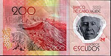
Since 2014, the peak along with the surrounding caldera were featured in a Capeverdean $200 escudo note. On the bottom left is the wine grape which is grown in the area and on the right Henrique Teixeira de Sousa, a native of the island, birthplace of an area that includes the peak.
See also
[edit]Teide – Volcano in Tenerife
References
[edit]- ^ Jump up to: a b "Fogo". Global Volcanism Program. Smithsonian Institution. Retrieved 2018-10-11.
- ^ Jump up to: a b Cabo Verde, Statistical Yearbook 2015, Instituto Nacional de Estatística, p. 25
- ^ Jump up to: a b c S. F. Jenkins; et al. (20 March 2017). "Damage from lava flows: insights from the 2014–2015 eruption of Fogo, Cape Verde". Journal of Applied Volcanology. 6 (1). Bibcode:2017JApV....6....6J. doi:10.1186/s13617-017-0057-6. hdl:10220/43825.
- ^ Carracedo, Juan Carlos; Troll, Valentin R. (2021-01-01). "North-East Atlantic Islands: The Macaronesian Archipelagos". Encyclopedia of Geology. pp. 674–699. doi:10.1016/B978-0-08-102908-4.00027-8. ISBN 9780081029091. S2CID 226588940.
- ^ Jump up to: a b c d e f g h i "Volcano Watch: Fogo Volcano, Cape Verde Islands". Hawaiian Volcano Observatory. April 21, 1995. Retrieved 2018-10-11.
 This article incorporates text from this source, which is in the public domain.
- ^ Carrecedo, Хуан-Карлос; Перес-Таун, Франциско Дж.; Родригес-Гонсалес, Алехандро; Париж, Рафа; Тролль, Валентин Р.; Баркер, Эбигейл К. (июль 2015 г.). Фого, Кейп -Верде " Геология сегодня . 31 (4): 146–1 Bibcode : 2015geolt . doi : 10.1111/ttu . 128995452S2CID
- ^ Carrecedo, Хуан-Карлос; Перес-Таун, Франциско Дж.; Родригес-Гонсалес, Алехандро; Париж, Рафа; Тролль, Валентин Р.; Баркер, Эбигейл К. (2015). Фого, Кейп -Верде " Геология сегодня . 31 (4): 146–1 Bibcode : 2015geolt . doi : 10.1111/ttu . ISSN 1365-2451 . 128995452S2CID
- ^ Браун, Эмма (2015). «Островные валуны раскрывают древние мега-цунами» . Природа . doi : 10.1038/nature.2015.18485 . S2CID 182938906 . Получено 2015-10-06 .
- ^ "Фого Кальдера" . MTU Вулканы Страница . Мичиганский технологический университет . Получено 2007-10-17 .
- ^ Подпрыгнуть до: а беременный «Вулкан Фого в извержении» . Oceanpress.info. 23 ноября 2014 года. Архивировано с оригинала 23 ноября 2014 года.
- ^ Подпрыгнуть до: а беременный в Сусана Сальвадор (23 ноября 2014 г.). «Вулкан пожарного извергается и требует эвакуации Chã Das Caldeiras» (на португальском языке). Новости дневник . Архивировано с оригинала 29 ноября 2014 года.
- ^ Кристоф Нефф (10 декабря 2014 г.). «Извержение Пико До Фого из 23.11.2014 - извержение забывает ...» (по -французски). Блоги Le Monde на Lemonde.fr .
- ^ Кристоф Нефф (28 апреля 2015 г.). «Вернувшись на старика - Пико до Фого» (по -французски). Блоги Le Monde на Lemonde.fr .
- ^ Кристофер Нефф (22 ноября 2017 г.). «Lua Nha testemunha» - помните «фитографию» поездка на острова Кейп -Верде (Сантьяго/Страх) в ноябре 2017 года » (на французском языке). Блоги мир Lemonde.fr на Получено 1 октября
- ^ Kokfelt, TA (1998). Геохимическое и изотопное исследование острова Фого, острова Кейп -Верде . Докторская диссертация. Университет Копенгагена. п. 164.
- ^ Hildner, E.; Klügel, A; Hauff, F. (2011). Магма -хранение и восхождение во время извержения Фого, Кейп -Верде Архипелаг . Вклад в минералогию и петрологию.
Внешние ссылки
[ редактировать ]- Фого, острова Кейп -Верде в НАСА Земля
- "Фого" . Глобальная программа вулканизма . Смитсоновский институт .
Остров Фого |
|---|
