Джирисан

Вы можете помочь расширить эту статью с помощью текста, переведенного из соответствующей статьи на корейском языке . (Март 2022 г.) Нажмите [Показать] для важных инструкций по переводу. |
| Джирисан | |
|---|---|
 | |
| Самая высокая точка | |
| Возвышение | 1915 м (6 283 фута) |
| Известность | 1696 м (5564 фута) |
| Listing | Ultra |
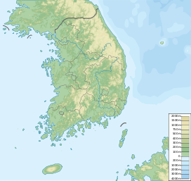
| Coordinates | 35°20′13″N 127°43′50″E / 35.33694°N 127.73056°E |
| Geography | |
 Jirisan | |
| Parent range | Sobaek Mountains |
| Climbing | |
| Easiest route | Hike |
| Korean name | |
| Hangul | 지리산 |
| Hanja | |
| Revised Romanization | Jirisan |
| McCune–Reischauer | Chirisan |
Джирисан ( корейский : 지리산 ) - гора, расположенная в южном регионе Южной Кореи . Это вторая гора в Южной Корее после Чеджу острова Халласана и самая высокая гора в материковой части Южной Кореи. [ 1 ]
Гора высотой 1915 м расположена в национальном парке Джирисан . Парк охватывает три провинции ( Север , Южная Челла и Южная Гёнсанг ), и он является крупнейшим в Южной Корее. Самая большая доля национального парка находится в провинции Южный Гёнсанг. Самая высокая вершина горы, Cheonwangbong также расположен в этой провинции. Другой известный пик- Samsinbong (пик трех духов).
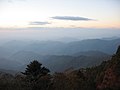
Jirisan is at the southern end of the Sobaek and Baekdu-daegan mountain ranges, the "spine" of the Korean Peninsula incorporating the Sobaek mountain range and most of the Taebaek mountain range.
There are seven major Buddhist temples on Jirisan. Hwaeomsa is the largest and best-known temple among these. It contains several national treasures, mostly stone artworks from about 600–900 CE. The mountain is also home to the Cheonghak-dong (Azure Crane Village) alpine valley, which includes the Samseonggung (Three Sages Palace), which is a site celebrating one of Korea's foundation myths.[2]
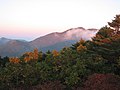
Every year more than 280,000 people visit Jirisan. Summer and autumn are the most popular visiting seasons. The mountain is advertised as having ten scenic views. These are ‘Sunrise from Cheonwang-bong peak’, ‘Nogodan Sea of Clouds’, ‘Banyabong’s Nakjo’, ‘Full moon at Byukso-ryung’, ‘Piagol Autumn Leaves’, ‘Royal Azalea Blossoming’, ‘Chilseon Valley’, ‘Seomjincheongryu’, ‘Buril water fall’, ‘Yeonha-Sunkyung’. Jirisan National Park has several hiking routes.
Legends
[edit]At the entrance to Baemsagol Valley, some 1,300 years ago, there used to be Songnimsa Temple. This temple practiced an annual rite on the Chilwolbaekjung holiday (full moon day of July by the lunar calendar) wherein they selected the most pious monk and prayed earnestly for his safe passage to paradise as a deity. In a certain year, the then highest monk Seosandaesa visited the temple, heard about this Buddhist rite, and guessed that there must be a secret behind it. Seosandesa allowed that year's chosen monk to pray wearing a silk robe anointed with poison, linked by a silk thread to Sinseodae Terrace. Seosandaesa then hid himself behind a rock to watch. At around 1 am, an imugi anaconda, which was sorry not to have turned into a dragon, slithered up from the valley below Sinseondae Terrace to the sound of roaring water. The imugi jumped upon the praying monk, bit him in the mouth, and disappeared into the water. Seosandaesa returned to the temple, and waited until dawn. Early in the morning, he, together with the villagers, went to Sinseondae Terrace to find that the imugi had died , having failed to swallow the whole body of the monk. Seosandaesa discovered Songnimsa Temple's secret of sacrificing a monk to an imugi every year. Thereafter, the valley was named Baemsagol, which means the valley where an imugi, which failed to become a dragon, died. The village at the entrance to Baemsagol Valley was named Banseon (meaning a "half deity") in memory of the dead monk because he was sacrificed without becoming a deity.[3]

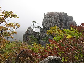
Peaks
[edit]This section is written like a travel guide. (March 2022) |
Samshinbong (bong means "peak") is 1,284 m (4,213 ft) high and a popular, but strenuous, day-hike from the Ssanggye Temple entry point (it is the closest major peak from this trailhead). From Ssanggyesa, a trail winds up 2.3 km to Bul-il Falls. From the left turn in the path just before the waterfall, the track continues 6.9 km to the peak (for a grand round-trip total of 18.4 km). Starting from Ssanggyesa (the sa suffix indicates a Buddhist temple), the peak can be reached in four hours at a steady pace. There is a helipad near the summit for emergency services. It takes about three hours to get down; it is an extremely steep hike. Climbers are advised to bring plenty of water as it is only available from streams beyond the temple grounds. This peak can also be climbed from the back of Cheonghak-dong Village.
History
[edit]During the Korean War, North Korean troops occupied the region in 1950. After the United Nations forces took the area in 1951, a considerable number of North Koreans remained in the mountains, where they continued a guerrilla war, until they were finally beaten in 1955, two years after the Korean Armistice Agreement was signed by the belligerents. South Korea issued an "Anti-Guerrilla Warfare Service Medal" for its troops who fought in the area[4] and a movie about the fighting was later produced.[5] An earlier film, Piagol, about a group of North Korean soldiers in the area, was released the year the fighting ended.
Ecosystem
[edit]Jirisan is known to grow about 1,500 kinds of plants, many of which are endemic. This is the largest growth of plants in South Korea except for Mt. Halla.
Some plants were first found in Mt. Jiri and have 'Jirisan' or 'Jirisan'. However, some plants do not have 'geori' or 'geori' attached to them even though they were first found on Mt. Jiri.[6]
Gallery
[edit]-
 Jirisan National Park
 -

-
-

-
 Baemsagol valley


See also
[edit]- National parks of South Korea
- List of mountains in Korea
- Geography of South Korea
- Mayago
- Korea Forest Service
- Jirisan (TV series)
References
[edit]- ^ "Highest Mountains South Korea". www.geonames.org.
- ^ "지리산" (in Korean). Retrieved 2018-06-14.
- ^ "뱀사골" (на корейском языке) . Получено 2018-06-14 .
- ^ «Республика Корея: Медаль борьбы с Гуеррилькой» . Медали мира . Получено 2013-04-07 .
- ^ «Северный корейский партизан в Южной Корее» . Корейский архив кино . Архивировано с оригинала 2012-05-28 . Получено 2013-04-07 .
- ^ «[Газета Сеула] [Цветы Хёнджино вдоль Санты] Джирисан» . Archive.fo . 2013-05-01. Архивировано из оригинала 2013-05-01 . Получено 2019-06-07 .
Внешние ссылки
[ редактировать ]- Домашняя страница KNPS национального парка Джирисана
- Онлайн -Mashup/интерактивная карта пешеходных троп Jirisan (на корейском языке)
- Корея в облаках: подробное руководство по походам в Кореи
- Джири-сан как священная гора , страницы Мейсона на религиозном характере и участки этого замечательного набора пиков, склонов и ущелье.