Auyuittuq National Park

| Auyuittuq National Park | |
|---|---|
 Пангниртунг -фьорд и долина реки Визель | |
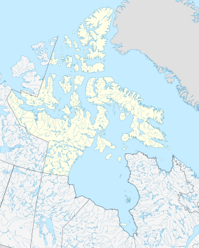
 Расположение национального парка Auyuittuq | |
| Location | Nunavut, Canada |
| Nearest city | Pangnirtung, Qikiqtarjuaq |
| Coordinates | 67°53′N 65°01′W / 67.883°N 65.017°W |
| Area | 21,470 km2 (8,290 sq mi) |
| Established | 1972 |
| Visitors | 256 (in 2022–23[2]) |
| Governing body | Parks Canada |
park ( iqaluittut : auduqiguq Auyuittuq IPA: [aujuitːuq] , «земля, которая никогда не тает») - это национальный парк , расположенный на острове Баффин на полуострове Камберленд , в регионе Цикикталук в Нунавуте , крупнейшем политическом подразделе Канады. Парк был первоначально известен как Национальный парк острова Баффин , когда он был основан в 1972 году, но название было изменено в 1976 году на его нынешнее название, чтобы лучше отразить регион и его историю. В нем представлено много территории арктической дикой природы, такие как фьорды , ледники и ледяные поля . Хотя Auyuittuq был основан в 1972 году как резерв национального парка , он был обновлен до полного национального парка в 2000 году.
Местоположение и доступ
[ редактировать ]Национальный парк Auyuittuq расположен на полуострове Камберленд на острове Баффин в Нунавуте . Парк расположен в арктическом круге . Парк охватывает 21 470 квадратных километров (8 290 кв. МИ) [ 3 ] [ Примечание 1 ] и расположен частично в пределах высокогорья Пенни и содержит 6000 км 2 (2300 кв. МИ) Пенни Ледяная Кап . [ 3 ] [ 4 ] Ледяной шапки Пенни, сделанный из льда, сидящего на докембрийском граните , создает серию ледников , в том числе коронационный ледник . Земля отражает геологическую историю области, с глубокими долинами между вершинами, которые включают в себя гору Асгард с лицом 800 м (2600 футов), и гору Тора с лицом 1250 м (4100 футов). Вдоль побережья глубокие, узкие фьорды . [ 3 ] В перевале Акшаюка ветры могут достигать 175 км/ч (109 миль в час). [5]
The nearest towns are Qikiqtarjuaq and Pangnirtung. Visitors wishing to enter the park are required by Parks Canada to register at the park office in Pangnirtung or Qikiqtarjuaq, and attend an orientation session.[4][5] Park user fees apply.
History
[edit]First established in 1972 as Baffin Island National Park, in 1975, Parks Canada chose to rename the park in order to better reflect the landscape and the Inuit history within the region. After some debate, the name was changed to Auyuittuq National Park, which is an Inuktitut word meaning "the place that does not melt".[3]
Flora and fauna
[edit]Little vegetation can be found in Auyuittuq Park, although the plants found there range from flowers such as mountain avens, campion, Papaver, and saxifrage to shrubs like dwarf birch, Arctic willow, and heather. Many of the plants in Auyuittuq Park grow in clumps to create their own warmer "microclimate" to survive the harsh Arctic conditions.
Because of the exceptionally low vegetation supply on land, wildlife is very scarce. However, the park is bordered on three sides by sea and marine life is found within the park's boundaries.[3] Species that live in Auyuittuq Park include lemmings (both the North American brown lemming and the northern collared lemming), red foxes, snowy owls, peregrine falcons, ermines, rough-legged hawks, gyrfalcons, beluga whales, snow geese, polar bears, wolves, narwhals, Canada geese, Arctic foxes, Arctic hares, and some barren-ground caribou.
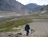
Activities
[edit]The most common backpacking route in the park is known as Akshayuk Pass, and follows the Weasel and Owl rivers via Summit Lake.[5] In 2008, heavy rain and warm weather caused Summit Lake to burst through its banks, flooding the Weasel River and washing away the Windy Lake bridge. As a result, the hiking routes in the pass are limited to either side of the Weasel River.[citation needed]
Gallery
[edit]-
 Mount Asgard, Baffin Island, 2001
 -
 Maktak Fiord Delta
 -
 Horseshoe-shaped lateral moraines at the margin of the Penny Ice Cap
 -
 Along the Weasel River, hiking to Mount Thor
 -

-
 Rock formations and glaciers. Turnweather Peak in the middle.
 -
 Weasel River Valley with Schwartzenbach Falls in the distance
 -
 Baffin Mountains from the air, Cumberland Peninsula
 -
 Summit Lake at Akshayuk Pass
 -
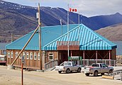 Auyuittuq National Park Office in Pangnirtung


See also
[edit]Notes
[edit]- ^ The Municipality of Pangnirtung website states that the park measures 19,089 square kilometres (7,370 sq mi).
Citations
[edit]- ^ "Protected Planet | Auyuittuq National Park Of Canada". Protected Planet. Retrieved 2020-11-05.
- ^ Canada, Parks. "Parks Canada attendance 2022_23 - Parks Canada attendance 2022_23 - Open Government Portal". open.canada.ca. Retrieved 2024-05-07.
- ^ Jump up to: a b c d e Lawrence, R. D. (1985) [1983]. Canada's National Parks (2nd ed.). Toronto, Ontario: Collins. p. 17. ISBN 0-00-217458-8.
- ^ Jump up to: a b "Auyuittuq National Park". Municipality of Pangnirtung. Archived from the original on 30 January 2019. Retrieved 30 January 2019.
- ^ Jump up to: a b c "Visitor Information Package". Parks Canada. 2017-05-30. Archived from the original on 18 October 2013. Retrieved 30 January 2019.
Further reading
[edit]- Ferguson, Steven H; Taylor, Mitchell K; Messier, Francois (1997). "Space Use by Polar Bears in and Around Auyuittuq National Park, Northwest Territories, During the Ice-Free Period". Canadian Journal of Zoology. 75 (10): 1585–1595. doi:10.1139/z97-785.
- Hines, James E.; Moore, Steve (1988). The Vegetation and Flora of Auyuittuq National Park Reserve, Baffin Island (PDF) (Report). Yellowknife, Canada: Department of Renewable Resources, Government of the Northwest Territories. Archived from the original (PDF) on 2016-03-04. Retrieved 2015-05-22.
- Konotepetz, Larry (1985). Archaeological Sites of Auyuittuq National Park Reserve. Microfiche report series, 315. Ottawa, Canada: Environment Canada, Canadian Parks Service. OCLC 59739479.
- Masterton, J. M.; Findlay, B. F. (September 1976). The Climate of Auyuittuq National Park, Baffin Island, Northwest Territories (PDF) (Report). Toronto, Canada: Atmospheric Environment Service, Meteorological Applications Branch, Environment Canada.
- Tarnocai, C. (1998). Monitoring the Integrity of Cultural Sites, Auyuittuq National Park Reserve (Report). Ottawa, Canada: Research Branch (ECORC), Agriculture and Agri-Food Canada.
- Wilson, Roger, ed. (1976). The Land That Never Melts Auyuittuq National Park. Toronto: Peter Martin Associates Limited in association with Indian and Northern Affairs and Pub. Centre, Supply and Services Canada. ISBN 0-88778-143-8.
External links
[edit]- Паркс Канада Официальный сайт
- Маунт Тор пик
- Информация и картинки-от отеля Tulugak Archived 2022-03-07 на The Wayback Machine
- Информация о национальном парке Auyuittuq
- Газетная статья о национальном парке Auyuittuq от Dallas Morning News Reporter Дейв Левинал