Маленький залив

Маленький залив | |
|---|---|
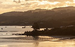 Залив Parua, показывающий Pacific Oyster ферму аквакультуры | |
 | |
| Координаты: 35 ° 46′12 ″ S 174 ° 27′33 ″ E / 35,77000 ° S 174,45917 ° E | |
| Страна | Новая Зеландия |
| Область | Нортлендский регион |
| Округ | Район Вангареи |
| Сторожить | Whangarei Heads Ward |
| Избиратели | |
| Правительство | |
| • Территориальная власть | Окружной совет Вангареи |
| • Региональный совет | Нортленд Региональный совет |
| Область | |
| • Общий | 1,87 км 2 (0,72 кв. МИ) |
| Население (Июнь 2023 г.) [ 2 ] | |
| • Общий | 670 |
| • Плотность | 360/км 2 (930/кв. МИ) |
Залив Паруа - это местность и залив на северной стороне гавани Вангарей в Нортленде , Новая Зеландия . Вангарей находится в 19 км к западу, а головы Вангарей находятся в 10 км к юго -востоку, с заливом Мунро между ними. Западная голова называется марганцевой точкой, а восточная - это точка резерва. Укумный уголок - небольшая бухта к северу от Резервного Пойнт. [ 3 ] [ 4 ]
Залив защищен и шириной около 4 км, с примерно одним километром между мышами. Центральная залива имеет глубокую воду, но вокруг побережья есть широкие литовые зоны. Остров Мотукиоре находится прямо в точке марганца и присоединился к нему в Coameway во время прилива, хотя единственный практический доступ к воде. Контуры оборонительной пары на острове все еще ясно видны. [ 5 ]
Точка Соломона делит залив на два. Точка названа в честь начальника маори Хоромона-Кайку. [ 5 ]
История
[ редактировать ]
Раро-Нгауа был Pā на восточной стороне входа в залив Паруа в начале 19-го века. В 1821 или 1822 году на эту Pā напала группа воинов Ngāti Paoa и Waikato в рамках мушкетных войн . [ 6 ]
В 1838 году Томас Стюарт Скотт и два партнера купили землю на западной стороне залива и установили судостроительный двор. Губернатор Фицрой , шхуна около 43 футов (13 м), был одним из кораблей, построенных здесь. Марганцевая руда лежала в комочках в точке к югу от верфи, которая тогда известна как Те Аро, но теперь называется марганцевой точкой. Руда была продана в 1844 году. [ 7 ] В 1849 году капитан Лорт Стоукс был проведен гидрографический обзор из гавани Вангарея в HMS Acheron . Он назвал залив Паруа «Плохой залив маори» и марганцевую точку «точка раздражения». [ 8 ]
К середине 1850-х годов на западной стороне залива жили четыре европейские семьи. [ 9 ] Правительство приобрело 10 000 акров (4000 га) в заливе Паруа в 1858 году, а земля была впоследствии урегулирована людьми, в основном в соответствии с «схемой сорок акра», которая дала посылку в 40 акров (16 га) любому поселенцам старше 18 лет, при условии нескольких условий. [ 10 ]
Ирландский геодезист по имени Джеймс Ирвин Уилсон поселился в уголке в 1858 году и влюбился в Джоанну Мунро, дочь поселенца Новой Шотландии из залива Мунро. Ее отец, Джон Манро, был недоволен тем, что Уилсон купил землю, которую он хотел, и выступил против их союза. Пара пыталась сбежать, но ее поймали. Второе разгоновление было успешным, и они поженились в Окленде. Джон Мунро в конце концов принял брак, и один из братьев Джеймса позже женился на сестре Джоанны. [ 5 ] [ 11 ]
Demographics
[edit]Statistics New Zealand describes Parua Bay as a rural settlement. The settlement covers 1.87 km2 (0.72 sq mi)[1] and had an estimated population of 670 as of June 2023,[2] with a population density of 358 people per km2. The settlement is part of the larger Parua Bay statistical area.
| Year | Pop. | ±% p.a. |
|---|---|---|
| 2006 | 399 | — |
| 2013 | 477 | +2.58% |
| 2018 | 597 | +4.59% |
| Source: [12] | ||
Parua Bay settlement had a population of 597 at the 2018 New Zealand census, an increase of 120 people (25.2%) since the 2013 census, and an increase of 198 people (49.6%) since the 2006 census. There were 207 households, comprising 306 males and 297 females, giving a sex ratio of 1.03 males per female, with 162 people (27.1%) aged under 15 years, 48 (8.0%) aged 15 to 29, 285 (47.7%) aged 30 to 64, and 102 (17.1%) aged 65 or older.
Ethnicities were 91.5% European/Pākehā, 11.6% Māori, 1.0% Pacific peoples, 3.5% Asian, and 3.5% other ethnicities. People may identify with more than one ethnicity.
Although some people chose not to answer the census's question about religious affiliation, 61.3% had no religion, 25.1% were Christian, 0.5% were Hindu, 1.0% were Buddhist and 3.0% had other religions.
Of those at least 15 years old, 159 (36.6%) people had a bachelor's or higher degree, and 45 (10.3%) people had no formal qualifications. 93 people (21.4%) earned over $70,000 compared to 17.2% nationally. The employment status of those at least 15 was that 204 (46.9%) people were employed full-time, 87 (20.0%) were part-time, and 15 (3.4%) were unemployed.[12]
Parua Bay statistical area
[edit]Parua Bay statistical area covers 39.16 km2 (15.12 sq mi)[1] and had an estimated population of 2,700 as of June 2023,[13] with a population density of 69 people per km2.
| Year | Pop. | ±% p.a. |
|---|---|---|
| 2006 | 1,926 | — |
| 2013 | 2,013 | +0.63% |
| 2018 | 2,460 | +4.09% |
| Source: [14] | ||
The statistical area had a population of 2,460 at the 2018 New Zealand census, an increase of 447 people (22.2%) since the 2013 census, and an increase of 534 people (27.7%) since the 2006 census. There were 918 households, comprising 1,221 males and 1,239 females, giving a sex ratio of 0.99 males per female. The median age was 49.7 years (compared with 37.4 years nationally), with 471 people (19.1%) aged under 15 years, 231 (9.4%) aged 15 to 29, 1,152 (46.8%) aged 30 to 64, and 606 (24.6%) aged 65 or older.
Ethnicities were 90.4% European/Pākehā, 15.1% Māori, 2.0% Pacific peoples, 2.6% Asian, and 1.7% other ethnicities. People may identify with more than one ethnicity.
The percentage of people born overseas was 25.0, compared with 27.1% nationally.
Although some people chose not to answer the census's question about religious affiliation, 59.5% had no religion, 29.6% were Christian, 0.5% were Hindu, 0.7% were Buddhist and 2.3% had other religions.
Of those at least 15 years old, 510 (25.6%) people had a bachelor's or higher degree, and 294 (14.8%) people had no formal qualifications. The median income was $35,900, compared with $31,800 nationally. 435 people (21.9%) earned over $70,000 compared to 17.2% nationally. The employment status of those at least 15 was that 894 (44.9%) people were employed full-time, 300 (15.1%) were part-time, and 63 (3.2%) were unemployed.[14]
Education
[edit]Parua Bay School is a coeducational full primary (years 1–8) school with a roll of 284 students as of August 2024.[15][16]
Notes
[edit]- ^ Jump up to: a b c "ArcGIS Web Application". statsnz.maps.arcgis.com. Retrieved 26 December 2023.
- ^ Jump up to: a b "Subnational population estimates (RC, SA2), by age and sex, at 30 June 1996-2023 (2023 boundaries)". Statistics New Zealand. Retrieved 25 October 2023. (regional councils); "Subnational population estimates (TA, SA2), by age and sex, at 30 June 1996-2023 (2023 boundaries)". Statistics New Zealand. Retrieved 25 October 2023. (territorial authorities); "Subnational population estimates (urban rural), by age and sex, at 30 June 1996-2023 (2023 boundaries)". Statistics New Zealand. Retrieved 25 October 2023. (urban areas)
- ^ Peter Dowling, ed. (2004). Reed New Zealand Atlas. Reed Books. pp. map 8. ISBN 0-7900-0952-8.
- ^ Roger Smith, GeographX (2005). The Geographic Atlas of New Zealand. Robbie Burton. pp. map 28. ISBN 1-877333-20-4.
- ^ Jump up to: a b c Parkes, W. F. (1992). Guide to Whangarei City and District. pp. 28–30. ISBN 0-473-01639-7.
- ^ Pickmere, Nancy Preece (1986). Whangarei: The Founding Years. p. 4.
- ^ Pickmere, pp 25-26
- ^ Pickmere, pp 119-120
- ^ Pickmere, p 50
- ^ Pickmere, pp 68-9, 78
- ^ Pickmere, p 78
- ^ Jump up to: a b "Statistical area 1 dataset for 2018 Census". Statistics New Zealand. March 2020. 7000784–7000785 and 7000787–7000788.
- ^ "Population estimate tables - NZ.Stat". Statistics New Zealand. Retrieved 25 October 2023.
- ^ Jump up to: a b "Statistical area 1 dataset for 2018 Census". Statistics New Zealand. March 2020. Parua Bay (108500). 2018 Census place summary: Parua Bay
- ^ "New Zealand Schools Directory". New Zealand Ministry of Education. Retrieved 17 September 2024.
- ^ Education Counts: Parua Bay School