Внутренние терайские долины Непала
Внутренние терайские долины Непала составляют несколько удлиненных речных долин в южной части низменной терайской части страны. Эти тропические долины заключены в Гималайские предгорья, а именно на хребте Махабхарат и холмы Сивалдика дальше на юг. [ 1 ] [ 2 ]
Эти долины являются частью Terai-Duar и пастбищ экорегиона . [ 3 ] Они заполнены грубыми и тонкими аллювиальными отложениями . [ 4 ] и Долины Читван долины Дэнд и Деухури являются одними из крупнейших долин внутренней терайской долины. Малярия была распространена в этом регионе до конца 1950 -х годов. С момента своей ликвидации этот район стал жизнеспособным направлением для крупномасштабной миграции людей с холмов, которые превратили этот район из девственного леса и пастбищ в сельскохозяйственные угодья. [ 5 ]
Геология
[ редактировать ]
Внутренние долины терай лежат между хребтом Sivalik Hills и Mahabharat . Они держат плоские равнины со извилистыми реками, которые время от времени меняют свои курсы, бегая на северо -запад или юго -восток вдоль оси холмов Сивалдика.
Climate
[edit]
The Terai has a humid, subtropical climate. The mean annual rainfall at the Rampur weatherstation in Chitwan was 2,214 mm (87.2 in) between 1995 and 2006. More than 80% of the total annual rainfall occurs during the monsoon season from June to September. Average temperatures ranged from 8.08 °C (46.54 °F) in January to 34.91 °C (94.84 °F) in June.[6]
In the past, the inner and outer Terai were a formidable barrier between Nepal and potential invaders from India because marshes and forests were infested by anopheline mosquitos that transmitted virulent strains of malaria, especially during the hot spring and rainy summer monsoon.
History
[edit]Until the mid 18th century, the Terai was divided into several smaller kingdoms, and the forests were little disturbed.[7] After the unification of Nepal in the late 1760s, the rulers granted large areas of fertiIe land and forest resources to members of the royal family, officials, priests and selected groups of the society. The beneficiaries of these grants had the right to collect revenues from cultivated land and forest products. They appointed tax collectors who were also responsible for reclamation of land and establishment of settlements.[8] In the late 1920s, the Rana rulers ordered the clearing of forests and extraction of timber for export to India in order to collect revenues. Cleared areas were subsequently used for agriculture.[7]
Tharu people have been living in the Terai for many centuries, and reputedly had an innate resistance to malaria.[9] After malaria was eradicated using DDT in the mid-1950s, people from the hills migrated to the Terai. Timber export continued to 1969. In 1970, the king granted land to loyal ex-army personnel in the districts of Jhapa, Sunsari, Rupandehi and Banke, where seven colonies were developed for resettling about 7,000 people. They acquired property rights over uncultivated forest and waste land, thus accelerating the deforestation process in the Terai.[8]
Environmental issues
[edit]The well-meaning malaria eradication campaign has had unexpected consequences by opening up the Terai region to human settlement. The Inner Terai valleys are home to a rich and diverse ecosystem. Since the early 1990s, however, the forests have been increasingly destroyed because of growing demands for timber and agricultural land.[10][11] This has led to concerns about the risk of losing many rare plants.[12][13]
The valleys also mitigate the severity of floods on the Gangetic plains. During heavy rainfall forests absorb water. During floods, rivers overflow their banks and flood adjacent forests. Later the forests gradually release water back into the rivers. Deforestation reduces this buffering effect. It also accelerates soil erosion, causing downstream rivers to silt up and overflow their banks.[14] The frequency and severity of flooding in the Gangetic plain and Bangladesh has steadily increased in recent years. Deforestation of the Terai appears to be one of the major causes.[15] The Indian and Nepalese governments are cooperating in measures including construction of barrages and dams in the Terai, such as the Koshi Barrage.[16] However, these efforts may have mixed results. They contain floodwater in the short term, but may increase the problem in the longer term by reducing water velocity in the rivers downstream, and thus accelerating silting and reducing the drainage capacity of the rivers.[17]
Valleys
[edit]The major Inner Terai Valleys are listed from west to east. Click on the terrain and satellite imagery links to see vegetation, rivers, topography, roads and towns.
Western Terai
[edit]Markers at valleys Jogbudha (J), Surkhet (S), Dang (A) and Deukhuri (E) terrain satellite
Surkhet Valley
[edit]
The Surkhet Valley is situated in the Surkhet district, mid-western Nepal. The valley is about 700 m (2,300 ft) above sea level, forming an ellipse about 9 km (5.6 mi) east-west by 6 km (3.7 mi) north-south. It is drained by the Bheri River, a tributary of the Karnali.[18] The district is the homeland of the Raji people.[19] Tharu people from Dang settled in the valley since at least the 19th century.[20]
Imagery of Surkhet (S): terrain satellite
Dang and Deukhuri Valleys
[edit]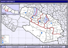
Both valleys are located in the Dang Deukhuri District of the Rapti Zone in mid-western Nepal.[20] The Dang Valley lies between the Mahabharat Range in the north and the Churia Range in the south.[21] It forms a nearly 1,000 km2 (390 sq mi) plain within a local drainage basin of less than 3,000 km2 (1,200 sq mi). It is drained by the Babai River, and is one of the largest Inner Terai valleys.[22]
The Deukhuri Valley is southeast of the Dang Valley and extends about 60 km (37 mi) in WNW-ESE direction with a maximum width of 20 km (12 mi).[23] It forms a nearly 600 km2 (230 sq mi) plain within a drainage basin of 6,100 km2 (2,400 sq mi).[22] The valley is drained by the West Rapti River.[23]
The Mahendra Highway passes through the Deukhuri Valley.[22] Both valleys are settled by Tharu people.[20]
Imagery of Dang (A) and Deukhuri (E): terrain satellite
Central Terai
[edit]Chitwan Valley
[edit]The Chitwan Valley, the biggest valley in Nepal, encompasses the districts of Makwanpur, Chitwan and Nawalpur of central Nepal. The Chitwan Valley lies south-west of the Kathmandu valley and it has 600 square miles in area. After the re-structuring of the country in 2015, two districts of this valley, namely, Makwanpur and Chitwan lies in Bagmati Province and Nawalpur district lies in Gandaki Province. It is 150 km (93 mi) long and roughly 30–48 km (19–30 mi) wide. The cities of Bharatpur, Ratnanagar, Hetauda and Kawasoti are in the valley. It is drained by the Rapti River flowing from the Mahabharat Range near Hetauda, then west down the valley to join the bigger Narayani River west of Meghauli situated within the valley.
Imagery of Chitwan (C): terrain satellite
The Chitwan National Park, Nepal's first national park established in 1973, was declared a World Heritage site by UNESCO in 1984. It contains the largest and least disturbed natural Sal hill forest and associated communities. Its fauna comprises Bengal tiger, Indian leopard, great one-horned rhinos, wild Asian elephant, gaur, golden monitor lizard, gharial and marsh crocodile.[24]
Eastern Terai
[edit]Kamala Valley
[edit]
The Kamala Valley, also called Udayapur Valley is in Udayapur district in southeastern Nepal. It is about 30 km (19 mi) long and between 2 km (1.2 mi) and 4 km (2.5 mi) wide. It is drained by the Triyuga river flowing east to join the great Koshi River. This valley lies between the Mahabharat Range to the north and the Sivalik Hills to the south, with an average elevation of about 430 m (1,410 ft).[25]
The mouth of the valley opens onto a 175 km (109 mi) rectangle of land where the Triyuga meets the Koshi river above the Koshi Barrage. It was designated the Koshi Tappu Wildlife Reserve in 1976, and is home to the last remaining population of wild Asian water buffalo in Nepal. The reserve is mostly wetlands, subject to seasonal flooding, but also includes some grasslands and small patches of riverine forest. It is a Ramsar Site.[24]
Imagery of Kamala valley: terrain satellite
Traditionally, the Kamala Valley was primarily inhabited by the Dhanwar people (or Danuwar),[26] but there is a fast-growing population of migrants from the Nepali hills and from India.
References
[edit]- ^ Gurung, H. (1971). "Landscape pattern of Nepal". Himalayan Review (4): 1–10.
- ^ Nagendra, H. (2002). "Tenure and forest conditions: community forestry in the Nepal Terai". Environmental Conservation. 29 (4): 530–539. doi:10.1017/S0376892902000383. S2CID 86632135.
- ^ Dinerstein, E., Loucks, C. (2001). "Terai-Duar savanna and grasslands". Terrestrial Ecoregions. World Wildlife Fund.
- ^ Hasegawa S.; Dahal, R. K.; Yamanaka M.; Bhandary N. P.; Yatabe R.; Inagaki H. (2009). "Causes of large-scale landslides in the Lesser Himalaya of central Nepal". Environmental Geology. 57 (6): 1423–1434. Bibcode:2009EnGeo..57.1423H. doi:10.1007/s00254-008-1420-z. S2CID 59490114.
- ^ Gurung, H. (1988). "Nepal: Consequences of migration and policy implications". Contributions to Nepalese Studies. 15 (1): 67–94.
- ^ Department of Hydrology and Meteorology (2006). Climatological Records of Nepal (Several Volumes), Babarmahal, Kathmandu.
- ^ Jump up to: a b Gautam, A. P., Shivakoti, G. P., & Webb, E. L. (2004). A review of forest policies, institutions, and changes in the resource condition in Nepal. International Forestry Review 6 (2): 136–148.
- ^ Jump up to: a b Regmi, R. R. (1994). Deforestation and Rural Society in the Nepalese Terai. Occasional Papers in Sociology and Anthropology 4: 72–89.
- ^ Terrenato, L., Shrestha, S., Dixit, K.A., Luzzatto, L., Modiano, G., Morpurgo, G., Arese, P. (1988). "Decreased malaria morbidity in the Tharu people compared to sympatric populations in Nepal". Annals of Tropical Medicine and Parasitology. 82 (1): 1–11. doi:10.1080/00034983.1988.11812202. PMID 3041928.
{{cite journal}}: CS1 maint: multiple names: authors list (link) - ^ "Regional Workshop on Issues, Challenges and Opportunities for Forest Management of Terai, Inner Terai and Churia in Nepal". Archived from the original on 2008-12-01. Retrieved 2008-10-10.
- ^ "Forests Monitor: The Terai Forests". Archived from the original on 2017-06-29. Retrieved 2008-10-10.
- ^ "Orchids in the Churiya Hills and their survival in Nepal" (PDF). Archived from the original (PDF) on 2008-12-19. Retrieved 2008-10-10.
- ^ An Overview of Floral Diversity in Wetlands of Terai Region of Nepal: M. Siwakoti, Natural History Museum, Tribhuvan University Swayambhu, Nepal
- ^ "Fluvial geomorphological analysis with special reference to flood hazard, Baghmati River basin, north Bihar, India". Archived from the original on 2008-09-22. Retrieved 2008-10-14.
- ^ "Recent floods in Bangladesh: Possible causes and solutions". Archived from the original on 1997-07-24. Retrieved 2008-10-14.
- ^ "Indian Ministry of Water Resources – Flood and centrally sponsored schemes (c)" (PDF). Archived from the original (PDF) on 2008-12-19. Retrieved 2008-10-13.
- ^ "Causes, Effects and responses to flooding: The UK and Bangladesh". Archived from the original on 2009-01-21. Retrieved 2008-10-14.
- ^ Yadav, S. K. (2002). Hydrological Analysis for Bheri-Babai Hydropower Project Nepal (PDF) (MSc. Thesis). Trondheim: The Norwegian University For Science and Technology. Archived from the original (PDF) on 2008-12-19. Retrieved 2008-10-11.
- ^ Thapa L. B., Dhakal T. M., Chaudhary R., Thapa H. (2014). "Medicinal Plants Used by Raji Ethnic Tribe of Nepal in Treatment of Gastrointestinal Disorders". Our Nature. 11 (2): 177–186. doi:10.3126/on.v11i2.9645.
{{cite journal}}: CS1 maint: multiple names: authors list (link) - ^ Jump up to: a b c Krauskopff, G. (1995). "The Anthropology of the Tharus: An Annotated Bibliography" (PDF). Kailash. 17 (3&4): 185–213.
- ^ Шармай, доктор (1988). Археологические останки долины Данг. Древний Непал 88: 8–15.
- ^ Jump up to: а беременный в Mugnier JL, Lethyy P., Mascle G., Huyghe P., Chalaron E., Vidal G., Delcaillau B. (1999). «Сивалики Западного Непала: I. Геометрия и кинематика». Журнал азиатских наук о Земле . 17 (5): 629–642. Bibcode : 1999jaec..17..629m . Doi : 10.1016/s1367-9120 (99) 00038-3 .
{{cite journal}}: Cs1 maint: несколько имен: список авторов ( ссылка ) - ^ Jump up to: а беременный Кимура, К. (1998). Геоморфное развитие Deukhuri Dun, Непал-суб-гималайя. Научные отчеты Университета Тохоку, 7 -й серии.
- ^ Jump up to: а беременный Bhuju, UR, Shakya, PR, Basnet, TB, Shresta, S. (2007). Книга ресурсов биоразнообразия Непала. Защищенные районы, рамсарские места и участки всемирного наследия (PDF) . Катманду: Международный центр интегрированного развития горы; Правительство Непала, Министерство окружающей среды, науки и техники; Программа окружающей среды Организации Объединенных Наций, Региональное управление Азиатской и Тихого океана. Архивировано из оригинала (PDF) 2011-07-26.
{{cite book}}: Cs1 maint: несколько имен: список авторов ( ссылка ) - ^ Дарси, RF JR; Pradhan, Sp & Vaidya, RG (1992). «Заметки о комарах Непала: II. Новые виды записей из коллекций 1991 года» . Москитовая систематика . 24 : 23–28. Архивировано из оригинала 2008-12-19 . Получено 2008-10-13 .
- ^ Khatry, P. (1995). Система Манджани штата Данувар в долине Камала: краткое изучение эгалитарной судебной системы . Вклад в непальские исследования 22 (1): 43–55.