Река

| Река | |
|---|---|
 | |
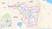 Tekezé-Senit River Watershand ( интерактивная карта ) | |
| Расположение | |
| Страны | |
| Physical characteristics | |
| Source | Ethiopian Highlands |
| • location | Birkumit, Ethiopia |
| • coordinates | 12°05′13″N 39°20′17″E / 12.087°N 39.338°E |
| • elevation | 3,110 m (10,200 ft) |
| Mouth | Atbarah River |
• location | near Wad Muzammil, Eritrea / Ethiopia / Sudan border |
• coordinates | 14°15′25″N 36°33′36″E / 14.257°N 36.560°E |
• elevation | 540 m (1,770 ft) |
| Length | 608 km (378 mi) |
| Basin size | 64,210 km2 (24,790 sq mi) |
| Basin features | |
| Progression | Atbarah River → Nile → Mediterranean Sea |
| River system | Nile |
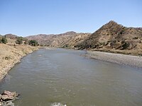
Река Текзезе [ 1 ] ( Amharic : ተከዜ ; Тигринья : ተከዘ первоначально означает «Почестер» в Ge'ez; : تكازي , таказза ) также пишется арабский , , [ 2 ] является крупной рекой в Эфиопии . Для части своего курса он образует часть самой западной границы Эфиопии и Эритреи . Река также известна как Setit ( арабский : سيتيت ), когда она присоединяется к реке притока Нила Атбара прямо над границей в Судане . Согласно материалам, опубликованным Центральным статистическим агентством Эфиопии , река Текезе имеет длину 608 километров (378 миль). [ 3 ] Каньон , который он создал, является самым глубоким в Африке и один из самых глубоких в мире, в некоторых моментах, имеющих глубину более 2000 метров (6562 фута). [ 4 ]
Курс
[ редактировать ]The Tekezé River rises in the central Ethiopian Highlands near Mount Qachen within Lasta, from where it flows west, north, then west again, forming the westernmost border of Ethiopia and Eritrea from the confluence of the Tomsa with the Tekezé at 14 ° 11′N 37 ° 31,7′E / 14,183 ° N 37,5283 ° E к лету между двумя странами и Суданом в 14°15′27″N 36°33′37″E / 14.25750°N 36.56028°E.[5] в северо -восточный Судан в The Tripoint он присоединяется к реке Атбара , которая является притоком Нила После въезда . Tekezé, возможно, является истинным верхним курсом Атбары, поскольку первое следует более длительному курсу до слияния двух рек.
The names of its main tributaries in Ethiopia from its source are: on the right bank Tahali, Meri, Tellare, Sullo, Arekwa, Gheoa, Wari, Firafira, Tocoro, and Gumalo Rivers; on the left bank Nili, Balagas, Saha, Bembea, Ataba, Zarima, and Kwalema Rivers.
History
[edit]The earliest known mention of the Tekezé is in an inscription from Aksum of king Ezana of Axum, where he boasts of a victory in a battle on its lower banks, near "the ford of Kemalke".[6] The Tekezé served as an early link between Ethiopia and Egypt; for example, the Kebra Nagast, which received its current form in the 13th century, states that king Menelik I returned to Ethiopia by following this river from Egypt (ch. 53). Augustus B. Wylde records a related tradition that near the source of the Tekezé, at the location of Eyela Kudus Michael church, is the true resting-place of the Ark of the Covenant.[7]
Between February and March 1936, during the Second Italo-Abyssinian War, thousands of Ethiopian troops were killed when the Italian Royal Air Force (Regia Aeronautica) attacked them with bombs and mustard gas as they retreated across the Tekezé.[8] In a successful Ethiopian counter-offensive, the Italians were forced to fall back from the Tekezé to Axum after the battle at Dembeguina Pass.
On 1 July 2021, the bridge crossing the Tekezé river was destroyed during the Tigray War. The International Rescue Committee was concerned that the humanitarian aid efforts in the region would be "even more severely hampered than before."[9]
Tekezé Dam
[edit]The Ethiopian government announced in July 2002 that they had formed a partnership with the China National Water Resources and Hydropower Engineering Corporation to construct a hydroelectric dam on the Tekezé, which would generate 300 megawatts of electricity. The project would cost US$224 million and take five years to complete.[10] Oweys Ibrahim, the project coordinator, announced on 12 December 2007 that construction was 82% complete, and included a 105-kilometer power line to Mekele.[11]
The Tekeze Hydro Electric project constructed the highest double curve arch dam in Africa, topping the previous highest, in Lesotho. The contractors behind the project were CWGS and it was completed in 2009. The resulting reservoir is 105 km2 large and it has a capacity of 9.3 billion m³ of water.[12]
Gallery
[edit]-
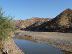
 Tekezé gorge, a few km downstream from the reservoir
 -
 A crocodile along the Tekezé River
 -
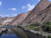
 A crossing at the Tekezé
 -
 "A view of the mountains of Samen & the River Tacazze", by Henry Salt and Charles Heath (1814)
 -
 Unknown person sitting next to a killed crocodile, 1881
 -
 Tekeze bridge, 2017


See also
[edit]Примечания
[ редактировать ]- ^ Riteler, Alfons. 2010. «Тяказ». Энциклопедия Aethiopica: Ox: Vol. 4, 823-8 Висбаден: Харасковиц.
- ^ Вебстера Новый географический словарь , Спрингфилд, Массачусетс: Merriam-Webster Inc., 1988, ISBN 0-87779-446-4 , P. 1.194.
- ^ «Климат, 2012 Национальная статистика (аннотация)» [ Постоянная мертвая ссылка ] , Таблица A.2. Веб -сайт Центрального статистического агентства (по состоянию на 25 октября 2015 г.)
- ^ «Водяная дилемма Эфиопии» (PDF) . Архивировано из оригинала (PDF) на 2007-02-08.
- ^ Эритрея - Решение Комиссии по границе Эфиопии относительно разграничения границы ... , с. 97, 101
- ^ Перевод с комментариями в GWB Huntingford, Историческая география Эфиопии (Лондон: Британская академия, 1989), с. 56-59.
- ^ Август Б. Уайлд, Современная Абиссиния (Лондон: Метуэн, 1901), с. 352
- ^ Barker, AJ, Изнасилование Эфиопии 1936 , Нью -Йорк: Ballantine Books Inc., 1971, с. 84, 91.
- ^ «Мост на реке Текез в эфиопии, разрушенном - группа помощи» . Рейтер . 2021-07-01 . Получено 2021-07-14 .
- ^ Китайская народная ежедневная онлайн . Доступ 20 апреля 2006 года.
- ^ «Строительство проекта Tekeze Hydro Electric Power, близится к завершению», Архивировано 2007-12-05 в The Wayback Machine ( Walta Information Center ), по состоянию на 2 декабря 2007 года.
- ^ Эннис, Софи; Ghebreyohannes, Tesfaalem; NYSSEN, январь. Влияние работы и управления плотиной гидроэнергетики на гидрогеоморфологию вниз по течению в полузасушливой среде (Tekeze, Northern Ethiopia). Вода, 2020, 12,8: 2237.
Внешние ссылки
[ редактировать ]- Карты Эфиопии - Коллекция карт библиотечных карт Перри -Кеста -Аньеда, Техасский университет в Остине
| Базы данных управления авторитетом : национальный |
|---|