Дания -Германи Граница
Эта статья требует дополнительных цитат для проверки . ( октябрь 2014 г. ) |


Дания - Германия Граница ( датский : Гринсен Меллем Данмарк Ог Тайкленд ; немецкий : граница между Данией и Германией ) составляет длину 68 километров (42 мили) и отделяет Данию и Германию .
История
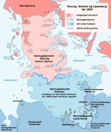
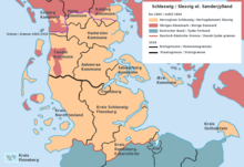
[ редактировать ]В договоре о Хейлигене , 811 год, Eider был признан границей между Данией и Франкской империей . [ 1 ] Как болотистая река, она сформировала естественную границу. На самой высокой области возле водосбора это была сушилка. Там построил очень старый путешествие Хервжен , и там была построена защитная стена, Даневирке . Позже появились герцогства Шлезвига и Гольштейна. До 1864 года Шлезвиг был частью Дании, в то время как Хольштейн был феодалом Священной Римской империи (до 1806 года) и членом Германской конфедерации (после 1815 года). Обе территории управляли датский король в его дополнительной роли герцога Шлезвига и герцога Гольштейна (иногда вместе с другими герцогами, такими как герцоги Gottorp). Граница между датским домом Шлезвига и немецким феодалом Гольштейна все еще проходила вдоль Эйдера , граница между герцогиями и Королевством Дании, проходившей вдоль Конгеена , и южная граница датской монархии (≈ Хелстатена) пробежала вдоль Элбе. Полем
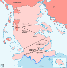
In 1864, Schleswig-Holstein was conquered by Prussia, and so an international border was created between Denmark and Germany/Schleswig-Holstein. It went from a place at the coast 5 kilometres (3.1 mi) south of Ribe, rounded Ribe on 5 kilometres (3.1 mi) distance, then went eastbound just south of Vamdrup, and just north of Christiansfeld to the Baltic Sea.
In 1920, the border was moved about 50 kilometres (31 mi) southward to the present position, as determined by the Schleswig referendum in 1920. This approximately followed the not clearly defined language border.
Border controls
[edit]In 2001, all border controls were removed based on the Schengen Agreement.
In response to the Swedish border control due to the European migrant crisis, border checks were temporarily introduced starting January 4, 2016. Prime minister Lars Løkke Rasmussen cited fear of accumulation of illegal migrants in Copenhagen as one of the reasons for this decision.[2] It was reported that the border controls at the German border cost the Danish tax payers 1.25 billion DKK (€167 million) from 2016 until mid-2019.[3] They were never fully ended before the COVID-19 pandemic in early 2020,[4] which caused renewed border closures throughout Europe.
To pass the border, an approved travel document is needed. This is mainly a passport. But also a national identity card from the European Economic Area is acceptable, although Denmark does not issue such cards, so a passport is needed for Danes.[5]
Wild boar fence
[edit]In January 2019, the Danish government began constructing a fence along the border to keep wild boar, which can carry African swine fever virus, from crossing into Denmark. The 1.5 metres (4.9 ft) high, nearly 70 kilometres (43 mi) long fence—spanning the entire land border—was completed in December 2019 at an estimated cost of 30.4 million Danish kroner.[6][7][8] The fence has created some protests. In May 2019 a volleyball tournament was held over the fence as a publicity event which was given some media attention.[9] After completion there was a decision to raise it by adding wires over it, because animals like deer have been killed after being injured because of jumping over the fence.[10]
-
 Western end of the fence at the Wadden Sea
 -
 Eastern end of the fence in the Flensburg Firth
 -
-
 Gendarmstien passing through the fence at Padborg


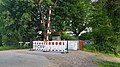
Border crossings
[edit]| Image | Danish Road/Track Name[11] | German Road/Track Name [11] | Type of crossing [11] | Characteristics[12] | Border checkpoint [12] | Coordinates [11] |
|---|---|---|---|---|---|---|
| Slusevej | - | Road | - | - | 54°54′40″N 8°38′19″E / 54.91115°N 8.63868°E | |
| Siltoftvej | - | Road | Old border checkpoint building | - | 54°54′41″N 8°40′11″E / 54.91131°N 8.6696°E | |
| Rudbølvej | Rosenkranzer-Straße | Road | National speed limits sign | Yes | 54°53′48″N 8°45′01″E / 54.89669°N 8.75033°E | |
| Møllehusvej | (L6) Landesstraße 6 | Road | National speed limits sign | - | 54°54′22″N 8°49′56″E / 54.90608°N 8.83231°E | |
| - | Marschbahn | Track | - | - | 54°53′58″N 8°52′22″E / 54.89938°N 8.87289°E | |
| Road | National speed limits sign | Yes | 54°54′14″N 8°54′37″E / 54.90385°N 8.91034°E | |||
| Vindtvedvej | - | Road | Small sign showing municipality | - | 54°54′00″N 8°57′46″E / 54.89996°N 8.96273°E | |
| Beierskrovej | Beyersweg | Road | Small sign showing municipality | - | 54°53′23″N 8°59′49″E / 54.88975°N 8.99681°E | |
| Pebersmarkvej | (L313) Pepersmarker Weg | Road | National speed limits sign | Yes | 54°52′18″N 9°04′44″E / 54.87165°N 9.07882°E | |
| Grænsevejen | Bögelhuus | Road | National speed limits sign | - | 54°52′23″N 9°08′31″E / 54.87303°N 9.14207°E | |
| Sofiedalvej | Zur Fehle | Road | National speed limits sign | - | 54°50′59″N 9°14′25″E / 54.84984°N 9.24032°E | |
| Kristiansmindevej | Wilmkjerweg | Road | Small sign showing municipality | - | 54°48′11″N 9°17′25″E / 54.80309°N 9.29032°E | |
| Road | National speed limits sign | Yes | 54°48′21″N 9°19′41″E / 54.80574°N 9.32817°E | |||
| Industrivej (Padborg) | (L17) Landesstraße 17 | Road | National speed limits sign | Yes | 54°48′58″N 9°21′40″E / 54.81615°N 9.36112°E | |
| Fredericia–Flensborg-banen | Bahnstrecke Fredericia–Flensburg | Track | - | - | 54°48′55″N 9°21′47″E / 54.81525°N 9.36301°E | |
| Haraldsvej | - | Walking path | - | - | 54°49′02″N 9°21′49″E / 54.8172°N 9.36373°E | |
| Rønsdamvej | - | Walking path | Red-white boom barrier | - | 54°50′02″N 9°22′33″E / 54.8338°N 9.37583°E | |
| - | - | Walking path | - | - | 54°50′20″N 9°23′07″E / 54.83876°N 9.38521°E | |

|
Road | National speed limits sign | Yes | 54°50′22″N 9°24′16″E / 54.83956°N 9.40443°E | ||
| Madeskovvej | Teichweg | Walking path | - | - | 54°50′32″N 9°24′26″E / 54.8422°N 9.40712°E | |
| Skomagerhusvej | Dammweg | Walking path | - | - | 54°49′55″N 9°25′13″E / 54.83198°N 9.42032°E |

See also
[edit]References
[edit]- ^ Thursten, Tina L. (2001). Landscapes of Power, Landscapes of Conflict: State Formation in the South Scandinavian Iron Age. New York: Kluwer Academic. p. 340. ISBN 0-306-44979-X.
- ^ "Berlingske | Læs nyheder på berlingske.dk".
- ^ Grænsekontrollen har nu kostet mindst 1,25 milliarder kroner
- ^ Nielsen, Nikolaj (2019-12-09). "Revealed: little evidence to justify internal border checks". EUobserver. Archived from the original on 2019-12-12. Retrieved 2021-07-21.
- ^ Rejselegitimation
- ^ «Строительство начинается на заборе о диком кабане» (пресс -релиз). Копенгаген: Министерство окружающей среды и продовольствия Дании. 28 января 2019 года. Архивировано с оригинала 19 декабря 2020 года . Получено 29 января 2019 года .
- ^ Топп, Андерс (28 января 2019 г.). «Дания начинает строить заборы против дикого кабана» . Докторд. Датское радио . Получено 29 января 2019 года . ( На датском )
- ^ Уолш, Алистер (28 января 2019 г.). «Дания начинает строить борьбу с пограничной точки зрения» . DW.com . Deutsche Welle . Получено 29 января 2019 года .
- ^ «Молодые люди играли в волейбол над ограждением дикого кабана» . Датское радио (на датском). 19 мая 2019 года . Получено 19 мая 2019 года .
- ^ «Обор диких кабанов изменяется, чтобы не повредить дикую игру» (на датском языке). 11 декабря 2019 года.
- ^ Подпрыгнуть до: а беременный в дюймовый Смотрите карты Google для соответственно координации.
- ^ Подпрыгнуть до: а беременный Смотрите Google Street View для соответственно координации.