Аль Шамаль

Аль Шамаль
Арабский ( арабский ) | |
|---|---|
 Стоматолог Форт | |
 Map of Qatar with Ash Shamal highlighted | |
| Coordinates (Madinat ash Shamal): 26°04′N 51°08′E / 26.07°N 51.13°E | |
| Country | |
| Capital | Madinat ash Shamal |
| Zones | 3 |
| Government | |
| • Mayor | Hamad Jumaa Al Mannai |
| Area | |
| • Total | 859.8 km2 (332.0 sq mi) |
| Population (2015)[1] | |
| • Total | 8,794 |
| • Density | 10/km2 (26/sq mi) |
| Time zone | UTC+03 (East Africa Time) |
| ISO 3166 code | QA-MS |
Аль -Шамаль ( арабский : ٱلشَّمَال , Романизированный : Эш Шамал ) - это муниципалитет в штате Катар . Его место называется Мадинат Эш Шамаль , и оно считается одним из крупнейших городов Катара, [ 2 ] Хотя население всего более 7000. Название места переводится как «Город севера». [ 3 ]
Рас Ракан , самая северная точка на полуострове Катар , включен в муниципалитет и как таковой окружен Персидским заливом во всех направлениях, кроме юга. Он граничит с муниципалитетом Аль -Хор . Муниципалитет разделен на три первичные зоны.
История
[ редактировать ]

Муниципалитет Аль -Шамала был основан в июле 1972 года вместе с четырьмя другими первоначальными муниципалитетами Катара. [ 4 ]
Accommodating less than 9,000 inhabitants, Al Shamal is the least populous municipality in the country. As it comprises the northernmost portion of the country, its historic importance is attributed to its more moderate weather and close proximity to Bahrain.[5]
The traditional mainstay of its inhabitants was fishing and pearling.[5] As early as the 16th century, Al Huwailah, located on the east coast of Al Shamal, served as Qatar's chief town. It was eventually overtaken by Al Zubarah, a town located in the western section of the municipality, which grew to be the largest and most important settlement in Qatar during the 18th century.[6] A survey conducted by the British Hydrographic Office in 1890 reflects on the subsequent abandonment of Al Zubarah and also provides details of the surrounding area's geography:
"Ras Ashiraj [Ras Ushayriq] is a low rocky point, 16 miles S.W. of Ras Rakkin, to the eastward of which is a bay 1½ miles deep, but shallow. On the east side of this bay stands the once important town of Zubara, of which extensive ruins are still to be seen; it is now abandoned, and the inhabitants have removed to Moreyr [Murair]. Vessels from Bahrain to Zubara generally sight Ras Rakkin, and then skirt the shore reef in 4 or 5 fathoms, till Khor Hassan tower is sighted. The large fort at Moreyr should then be seen; it is situated on slightly rising ground, about 1½ miles inland, between Zubara and Fariha."[7]
A unique system of partnership between coastal and inland villages was historically prevalent. Groundwater would be very difficult to obtain from settlements located directly on the coast due to the intrusion of seawater. Thus, coastal villages would trade prized marine resources such as fish in exchange for resources obtainable only from inland areas such as freshwater and crops. Examples of these historical partnerships include the Fuwayrit–Zarqa partnership and the Al Ghariyah–Al `Adhbah partnership. Another way settlements obtained freshwater was by excavating rawdas to create small reservoirs that would fill during rainy season.[8]
Proceeding the discovery of oil, most of Al Shamal's population migrated to the capital Doha.[5] In the mid-20th century, the region once again experienced significant population outflow due to upper aquifer salinization resulting from the overuse of diesel-powered water pumps. Nonetheless, once Qatar had begun reaping profits from its oil extraction activities, many northern settlements became repopulated as it became feasible to transport water over longer distances.[9]
Geography
[edit]Accounting for roughly 7% of Qatar's overall landmass, Al Shamal is the northernmost municipality, its outermost point being Ras Rakan.[10] It has around 80 km of coastline.[11] According to the Ministry of Municipality and Environment, the municipality accommodates 101 rawdas, 41 wadis, 51 jeris (places where water flows), 77 plains, 13 hills, three highlands, 12 sabkhas, 12 capes, one bay, and three coral reefs. Three islands are found off its shores: Jazirat Al Khuwayr, Jazirat Umm Tais, and the northern extremity of Jazirat Ras Rakan.[12]

Abu Dhalouf and Ar Ru'ays were the largest villages on the northern coastline until the 1970s, when the Qatari government enacted a plan to establish Madinat ash Shamal between these two villages. Throughout the 1970s, a road system and a port were built to connect the three villages. Development of Madinat ash Shamal continued through the 1980s and 1990s, whereas urban developments were carried out on the adjacent settlements of Abu Dhalouf and Ar Ru'ays in the 2000s. At present, these three villages are the commercial and administrative centers of the municipality.[10]
The majority of Al Shamal's settlements are rural, consisting mainly of small villages and farms. Most of Qatar's archaeological sites, abandoned villages and protected areas can be found in the municipality.[10] Development is mainly oriented towards the three adjacent villages of Madinat ash Shamal, Abu Dhalouf and Ar Ru'ays, and the village of Ain Sinan, with the bulk of development occurring in Madinat ash Shamal.[13]
Climate
[edit]The following is climate data for the town of Ar Ru'ays on the northern coast.
| Climate data for Ar Ru'ays | |||||||||||||
|---|---|---|---|---|---|---|---|---|---|---|---|---|---|
| Month | Jan | Feb | Mar | Apr | May | Jun | Jul | Aug | Sep | Oct | Nov | Dec | Year |
| Mean daily maximum °C (°F) | 22 (72) |
24 (75) |
28 (82) |
34 (93) |
39 (102) |
42 (108) |
43 (109) |
43 (109) |
40 (104) |
35 (95) |
30 (86) |
25 (77) |
34 (93) |
| Mean daily minimum °C (°F) | 13 (55) |
14 (57) |
17 (63) |
22 (72) |
27 (81) |
30 (86) |
31 (88) |
32 (90) |
29 (84) |
26 (79) |
18 (64) |
14 (57) |
23 (73) |
| Average precipitation mm (inches) | 13 (0.5) |
2 (0.1) |
2 (0.1) |
5.5 (0.22) |
1 (0.0) |
0 (0) |
0 (0) |
0 (0) |
0 (0) |
0.5 (0.02) |
15 (0.6) |
23 (0.9) |
62 (2.44) |
| Average relative humidity (%) | 77 | 71 | 57 | 52 | 41 | 40 | 43 | 53 | 58 | 61 | 70 | 83 | 59 |
| Source: Qatar Statistics Authority[14] | |||||||||||||
Administration
[edit]The municipality is divided into 3 zones which are then divided into 162 blocks.[15] According to municipal officials, there are approximately 28 rural settlements of varying sizes situated outside the Madinat ash Shamal area. The majority of these settlements are nestled along Al Shamal Road. There is also a high propensity of abandoned villages scattered throughout the municipality.[16]
Administrative zones
[edit]
The following zones were recorded in the 2015 population census:[1]
| Zone no. | Settlements | Area (km²) | Population (2015) |
|---|---|---|---|
| 77 | Ain Sinan Madinat Al Kaaban Fuwayrit |
266.0 | 1,727 |
| 78 | Abu Dhalouf Zubarah |
427.2 | 1,660 |
| 79 | Madinat ash Shamal Ar Ru'ays |
166.6 | 5,407 |
| Municipality | 859.8 | 8,794 | |
Other settlements
[edit]Other settlements, abandoned villages and sites of interest in Al Shamal include:
- Ain Al Nuaman – village near the municipality's south-west coast.[17]
- Ain Mohammed – abandoned village near the municipality's north-west coast.[18] Hosts the Ain Mohammed Fort.[17]
- Al `Adhbah – village near the municipality's north-east coast.[17]
- Al `Arish – abandoned fishing village near the municipality's north-west coast.[19]
- Al Ghariyah – village near the municipality's north-east coast.[17]
- Al Ghashamiya – village near the municipality's east coast.[17]
- Al Huwaila – abandoned village near the municipality's south-east coast.[17] Previously served as Qatar's main town before the emergence of Zubarah and Fuwayrit.[20]
- Al Jumail – abandoned fishing village near the municipality's north-west coast.[19]
- Al Khasooma – coastal area near the municipality's north coast, east of Ar Ru'ays.[17]
- Al Khuwayr – abandoned fishing village near the municipality's north-west coast.[19]
- Al Mafjar – abandoned village near the municipality's north-east coast.[17][21]
- Al Marroona – village near the municipality's south-east coast.[17]
- Al Nabaah – abandoned village near the municipality's north-west coast.[17]
- Al Qa`abiyah – village near the north-center of Al Shamal.[17]
- Al Zeghab – village on the outskirts of Madinat ash Shamal.[17]
- Ar Rakiyat – village near the municipality's north-west coast.[17]
- Ath Thaqab – village near the municipality's north-west coast.[17]
- Freiha – abandoned village near the municipality's south-west coast.[17] It is closely associated with the historic town of Zubarah.[22]
- Ghaf Makin – village near the municipality's north-west coast.[17]
- Jebel Jassassiyeh – abandoned village near the municipality's north-east coast.[17]
- Khidaj – abandoned village near the municipality's north-west coast.[17]
- Lejthaya – village near the municipality's south-east coast.[17]
- Lisha – village near the municipality's east coast.[17]
- Murwab – abandoned village near the municipality's south-west coast.[17] It constitutes one of Qatar's largest Islamic-era settlements.[22]
- Ras Al Shindwie – village near the municipality's northern tip.[17]
- Ruwayda – abandoned village near the municipality's north-west coast.[17] It constitutes one of Qatar's largest archaeological sites.[22]
- Safya – village near the municipality's east coast, to the immediate south of the original village of Fuwayrit.[17]
- Sidriyat Makin – village near the municipality's north-west coast.[17]
- Umm Al Ghaylam – village near the north-center of Al Shamal.[17]
- Umm Al Hawa'ir – village near the municipality's north-east coast.[17]
- Umm Al Kilab – village near the center of Al Shamal.[17]
- Umm al Qubur – abandoned village near the municipality's south-west coast.[17]
- Umm Al Shuwail – abandoned site containing a fort located 1.1 km east of Zubarah.[23]
- Umm Jasim – village near the municipality's north-west coast.[17]
- Yoghbi – abandoned village near the municipality's south-west coast. It accommodates the earliest known Islamic-era settlement in Qatar.[24]
- Yusufiyah – abandoned village near the municipality's north-west coast.[17]
- Zarqa – village near the municipality's north-east coast.[17]
Organizational structure
[edit]
Ash-Shamal Municipality comprises four principal departments headed and managed by Hamad Jumaa Al Mannai, mayor of ash-Shamal Municipality as of 2016.[25]
The director's office, heading the director's assistants and the heads of the following departments:[26]
- Municipal Control Department
- Services Department
- Public Affairs Department
- Technical Affairs Department
Infrastructure
[edit]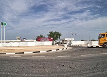
Education
[edit]Government statistics indicate that in 2015 the municipality accommodated 8 schools.[27] The majority of these schools are located in the northern portion of the municipality.[28]
Healthcare
[edit]There is one primary healthcare center in the municipality, located in Madinat ash Shamal. Residents in Al Shamal's eastern section, including Ain Sinan, are served by healthcare centers in Al Khor.[28]
Development projects
[edit]
Commercial fishing activities and cargo transport take place primarily at Ar Ru'ays Port, one of the three primary ports of Qatar.[29] Starting in 2010, the Public Works Authority (Ashghal) in Qatar carried out development on the port.[30] The development included construction of a basin, deepening the channel at 2900 meter length, passenger jetty, commercial crew jetty, protection wall, storage areas, government offices, workshops, and passenger terminal building.[31] Ar Ru'ays Port Development Project, which has the stated aim of "transforming Ar Ru'ays Port into northern Qatar's pathway to the world", was launched in January 2015.[32]
North of Fuwayrit, a major desalination plant is under development, while an expansion of a sewage treatment situated south of Madinat ash Shamal will supply local farmers with treated sewage effluent for agricultural use.[10]

The Public Works Authority (Ashghal) unveiled in October 2017 that they had begun the process of implementing more than 20 construction projects in the municipality at a cost exceeding QR 2.2 billion with a planned completion date of 2022. Roughly 60% of the total budget was to be spent on improving already-existing infrastructure while the remainder would be spent on funding new projects.[33]
As part of the plan, the municipality's transport system would see major improvements with its 73-km road system being renovated and the construction of 12 new intersections, 28 km of sidewalks, 8,000 parking spaces and 3,680 light poles. Most of these renovations and additions are set to take place near the municipality's major cities on its northern tip and its eastern section, near Al Huwailah. Also in the works was a 91 km sewage network. Most major sanitation facilities are to be located near Madinat ash Shamal and Ar Ru'ays. In Madinat ash Shamal, a 25,000 square meter healthcare facility and six educational institutes are to be constructed as part of this project.[33] Furthermore, several of the construction projects are intended to supplement the Ar Ru'ays Port.[34]
Transport
[edit]Al Shamal Road is the major highway facilitating travel to the capital Doha,[10] as well as between many villages within the municipality. Another important road is Al Zubarah Road, which links Zubarah to the Al Khor Municipality.[35] The Qatar–Bahrain Causeway was a major development project which would provide a causeway between Qatar and Bahrain near the town of Zubarah,[13] however, after several postponements, it is unclear if the project is still underway.[36]
Economy
[edit]
Industry
[edit]Al Shamal Industrial Area is the region's industrial hub. The municipality's long-term development plan suggests that the area will cater to light and medium industries such as manufacturing, construction and logistics, benefiting both Ar Ru'ays Port and the urban development of its principal towns.[37]
Agriculture
[edit]Around 14 sizable farming regions exist in the municipality, in the settlements of Ain Al Nuaman, Murwab, Zubarah, Lisha, Al `Arish, Ath Thaqab, Ar Ru'ays, Abu Dhalouf and Al Jumail in the west, and Al Mafjar, Athba Al Shamaliyya, Ain Sinan, Madinat Al Kaaban, and Al Jethay in the east.[38]
In 2010, the municipality recorded 115 farms spanning its area while the Ministry of Municipality & Urban Planning documented 125 farms, constituting about 12% of all of Qatar's farms at that time. Most of the farms were based in the eastern section, with Madinat Al Kaaban having the highest concentration.[38]
Qatar's inaugural privately owned large-scale fishing project was launched in the Al Shamal Industrial Area in October 2017. Up to 2,000 tonnes of fish will be supplied every year for domestic consumption by the fish farm.[39]
Sports
[edit]
Al-Shamal SC, a sports club most notable for its football team which competes in the Qatargas League, is situated in the city. Their home games are played at Al-Shamal SC Stadium in Madinat ash Shamal. Another stadium of the same name, Al-Shamal Stadium, is a proposed 45,120 capacity multi-purpose stadium currently under construction for the 2022 FIFA World Cup.[5]
Visitor attractions
[edit]
The Qatar Tourism Authority (QTA) is in the process of developing Al Shamal's historic villages, archaeological sites and natural areas into tourist attractions. As the municipality currently has the highest annual precipitation rate in the country and a large coastline area, the QTA has prioritized the establishment of eco-reserves in certain areas. Islands such as Ras Rakan and Umm Tais have been developed as nature reserves in order to boost eco-tourism.[5]
The Al Reem Biosphere Reserve is a protected area in western Al Shamal measuring 1,189 square kilometers in area. This area encompasses the archaeological site of Zubarah and the Al Ishriq Wildlife Breeding Center. Several reintroduced species are found in this area such as sand gazelles and ostriches, in addition to native species such as dugongs, spiny-tailed lizards and red foxes.[11]

Ar Ru'ays' coastal area is a popular destination due to its lush vegetation. In recent years, the Ministry of Municipality and Environment have embarked on campaigns to restore the mangroves that grow abundantly on its coast.[40] Also located along the coast of Ar Ru'ays is the Al Shamal Corniche, a seafront promenade with a length of 2,570 meters.[41] It was announced in 2017 that Qatar's largest health resort, due to cover 250,00 sq meters, will be built in Khasooma, east of Ar Ru'ays.[42]
Abandoned villages are also being restored and converted into tourist attractions. Jumail, a fishing village abandoned in the 1970s and located 5 km away from Ar Ru'ays, is one example. After being partially reconstructed in 2009, the government announced its plans in late 2015 to convert the village into a museum. Containing no less than 60 crumbled structure, Jumail is thought to date back to the 19th century and had a close connection to Ruwayda, another ruined village situated 1 km away which accommodates the remains of what is possibly the largest fort in Qatar.[43]
According to statistics made available by the Ministry of Municipality and Environment, the municipality was said to accommodate 5 parks in 2018.[44]
Forts
[edit]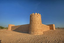
As a result of the gradual urbanization of the various nomadic Qatari tribes in Al Shamal's past, numerous historic forts are found throughout the municipality. Many of these forts were built to protect scarce water resources, while others were to protect from invasions by neighboring tribes.[45] Most prominent is the historic Zubarah Fort, built in 1938 and converted to a museum in 1987. This fort was built as a coast guard station and is now the center of the Zubarah archaeological site.[46] A short distance away from Zubarah Fort is Qal'at Murair, which was built to defend Zubarah's inland wells.[47]
Approximately 8 km northeast of Zubarah Fort is the multi-purpose Ar Rakiyat Fort.[48] Constructed around the 19th century to protect the water supply of Ar Rakiyat and to fend off invasions, this fort was restored by Qatar Museums in 1988.[49] An older fort is found 2 km away from Ar Rakiyat, near the abandoned village of Ath Thaqab.[48] Like most other Qatari forts, Ath Thaqab Fort is rectangular in shape and has four main towers. It dates to somewhere between the 17th and 19th centuries.[50]
Umm Al Maa Fort, also near Zubarah, dates to the 19th century and only its base structure has been preserved.[51] Similarly, Yusufiya Fort is dated to the 19th century and has only retained its base structure. Artifacts dating to the 13th century have been discovered at this fort.[50]
Archaeological sites
[edit]
A cluster of Abbasid-period (750–1253) archaeological sites are found near the north-west coast and include Ar Rakiyat, Umm Al Kilab, Ghaf Makin, Mussaykah, Murwab, and Al-Haddiyah. Structures that were excavated at these sites were roughly aligned with Mecca. All of the sites are situated next to rawdas (depressions), ensuring a reliable water supply.[52]
Demographics
[edit]| Year | Pop. | ±% |
|---|---|---|
| 1986[53][54] | 4,380 | — |
| 1997[53][54] | 4,059 | −7.3% |
| 2004[53][54] | 4,915 | +21.1% |
| 2010[55] | 7,975 | +62.3% |
| 2015[1] | 8,794 | +10.3% |
| c-census; e-estimate | ||


The following table is a breakdown of registered live births by nationality and sex for Al Shamal. Places of birth are based on the home municipality of the mother at birth.[56]
| ||||||||||||||||||||||||||||||||||||||||||||||||||||||||||||||||||||||||||||||||||||||||||||||||||||||||||||||||||||||||||||||||||||||||||||||||||||||||||||||||||||||||||||||||||||||||||||||||||||||||||||||||||||||||||||||||||||||||||||||||||||||||||||||||||||||||||||||||||||||||||||||||||
References
[edit]- ^ Jump up to: a b c "2015 Population census" (PDF). Ministry of Development Planning and Statistics. April 2015. Archived from the original (PDF) on 17 July 2016. Retrieved 8 August 2017.
- ^ "Welcome to MOFA web site". Archived from the original on 2011-09-03. Retrieved 2011-09-09.
- ^ "About Qatar". Civil Aviation Authority. Archived from the original on 9 August 2017. Retrieved 9 August 2017.
- ^ "Al Shamal Municipality". Ministry of Municipality and Urban Planning. Archived from the original on 23 September 2015. Retrieved 28 June 2015.
- ^ Jump up to: a b c d e "Al Shamal Regaining past glory". The Peninsula Qatar. 6 January 2013. Archived from the original on 24 July 2015. Retrieved 24 July 2015.
- ^ Fromherz, Allen (13 April 2012). Qatar: A Modern History. Georgetown University Press. p. 4. ISBN 978-1589019119.
- ^ The Persian Gulf pilot: comprising the Persian Gulf, Gulf of Omán; and Makran coast. Great Britain: Hydrographic Dept. 1890. p. 126. This article incorporates text from this source, which is in the public domain.
- ^ Walmsley, Alan; Richter, Tobias; Nymann, Hanne; Wordsworth, Paul David (2012). "Qatar Islamic Archaeology and Heritage Project : End of Season Report : 2010-2011" (PDF). University of Copenhagen and Qatar Museums Authority. pp. 94–97. Retrieved 18 February 2019.
- ^ Robert Carter and Daniel Eddisford (June 2016). "Origins of Doha Project - Season 4 Archive Report: Fuwairit Standing Building Recording" (PDF). Origins of Doha Project. p. 7. Retrieved 21 July 2018.
- ^ Jump up to: a b c d e "Al Shamal Municipality: Vision and Development Strategy" (PDF). Ministry of Municipality and Environment. December 2017. p. 4. Retrieved 22 May 2018.
- ^ Jump up to: a b "Al Shamal Municipality: Vision and Development Strategy" (PDF). Ministry of Municipality and Environment. December 2017. p. 26. Retrieved 22 May 2018.
- ^ «Сортативная таблица Geonames» . arcgis.com . Отдел географических информационных систем (Катар) . Получено 13 февраля 2019 года .
- ^ Подпрыгнуть до: а беременный «Муниципалитет Аль -Шамала: стратегия зрения и развития» (PDF) . Министерство муниципалитета и окружающей среды. Декабрь 2017 г. с. 15 Получено 22 мая 2018 года .
- ^ «Температура/влажность/количество осадков» . Управление по статистике Катара. Архивировано из оригинала 2013-03-22 . Получено 24 июня 2018 года .
- ^ «Административная граница карта» . Министерство планирования развития и статистики . Получено 10 июля 2018 года .
- ^ «Муниципалитет Аль -Шамала: стратегия зрения и развития» (PDF) . Министерство муниципалитета и окружающей среды. Декабрь 2017 г. с. 19 Получено 22 мая 2018 года .
- ^ Подпрыгнуть до: а беременный в дюймовый и фон глин час я Дж k л м не а п Q. ведущий с Т в v В х и С аа Аб и объявление Но из в «Районная карта» . Центр географических информационных систем Катара. Архивировано с оригинала 24 ноября 2020 года . Получено 25 мая 2018 года .
- ^ Рихтер, Т.; Nymann, H. (2011). «Катар Исламская Археология и Проект наследия: Конец сезона Отчет: Стадия 2, сезон 1, 2009–2010» (PDF) . Университет Университета Копенгагена и музеев Катара. п. 302 Получено 23 июня 2018 года .
- ^ Подпрыгнуть до: а беременный в "Рыбаки" деревни " . Исследуйте Катар . Получено 23 июня 2018 года .
- ^ «Гид Мараха по археологическим местам, фортам и руинам в Катаре» . Марахаб. 16 августа 2015 . Получено 23 июня 2018 года .
- ^ Шерен Д'Суза; Buthyna al-mohammadi (17 августа 2017 г.). «17 лучших дорог для путешествий в Катаре» . Время, Доха. Архивировано с оригинала 23 июня 2018 года . Получено 23 июня 2018 года .
- ^ Подпрыгнуть до: а беременный в «Поселения Катара» . Катарские музеи. Архивировано с оригинала 27 июля 2018 года . Получено 23 июня 2018 года .
- ^ Уолмсли, Алан; Рихтер, Тобиас; Ниманн, Ханн; Вордсворт, Пол Дэвид (2012). «Катар Исламская археология и проект наследия: Конец сезона Отчет: 2010-2011» (PDF) . Университет Университета Копенгагена и музеев Катара. п. 117 Получено 18 февраля 2019 года .
- ^ «QM, UCL Qatar Откройте для себя самое раннее исламское место в Катаре» . Залив времена. 6 марта 2019 года . Получено 10 марта 2019 года .
- ^ «3 Новые менеджеры Doha, Al -Dahhaniya и Al -Sayyin . » Аль -Райя. 18 июля 2016 года . Получено 8 августа 2017 года .
- ^ «112 Менеджеры и руководители отделения и офиса в 8 муниципалитетах» на арабском языке. Аль Шарк. 21 апреля 2017 года . Получено 8 августа 2017 года .
- ^ «Упрощенная перепись населения, жилья и учреждений 2015» (PDF) . Министерство муниципалитета и окружающей среды. Апрель 2015. С. 65–66. Архивировано из оригинала (PDF) 9 августа 2017 года . Получено 8 августа 2017 года .
- ^ Подпрыгнуть до: а беременный «Муниципалитет Аль -Шамала: стратегия зрения и развития» (PDF) . Министерство муниципалитета и окружающей среды. Декабрь 2017 г. с. 20 Получено 22 мая 2018 года .
- ^ "О нас" . Катарские порты Management Co. Архивирована из оригинала 30 июня 2018 года . Получено 29 июня 2018 года .
- ^ «Разработка порта аль -Рувайса - фаза 2» . Строительная неделя онлайн. 13 мая 2010 г. Архивировано с оригинала 8 августа 2017 года . Получено 8 августа 2017 года .
- ^ «Примечательные контракты» (PDF) . ReadyMix Qatar LLC 23 ноября 2011 г. Архивировано из оригинала (PDF) 14 мая 2013 года . Получено 8 августа 2017 года .
- ^ «Премьер запускает проект разработки порта Al Ruwais» . Катар процветает. 10 января 2015 года . Получено 23 мая 2018 года .
- ^ Подпрыгнуть до: а беременный «Более 20 проектов Ашгала для Аль -Шамала и Руваиса ведутся» . Полуостров. 22 октября 2017 года . Получено 25 июня 2018 года .
- ^ «Проекты QR2.2bn, реализованные в Шамале, Руваис» . Залив времена. 22 октября 2017 года . Получено 25 июня 2018 года .
- ^ «Муниципалитет Аль -Шамала: стратегия зрения и развития» (PDF) . Министерство муниципалитета и окружающей среды. Декабрь 2017 года. С. 29–30 . Получено 22 мая 2018 года .
- ^ Питер Ковесси (1 мая 2016 г.). «Саудовская политика призывает к новой дороге в Катаре» . Доха новости . Получено 23 мая 2018 года .
- ^ «Муниципалитет Аль -Шамала: стратегия зрения и развития» (PDF) . Министерство муниципалитета и окружающей среды. Декабрь 2017 г. с. 16 Получено 20 июля 2018 года .
- ^ Подпрыгнуть до: а беременный «Катарский атлас: сельское хозяйство/промышленность: сельское хозяйство» . Управление по статистике Катара. Архивировано из оригинала 2013-03-22 . Получено 24 июня 2018 года .
- ^ «Земля, выделенная для первого частного проекта рыбного земледелия» . Полуостров. 15 октября 2017 года . Получено 20 июля 2018 года .
- ^ «MME восстанавливает мангровые леса в прибрежной зоне Аль -Руваиса» . Полуостров. 18 мая 2018 года . Получено 25 июня 2018 года .
- ^ «Открытие проекта разработки Аль -Шамаль Корниш» . Ашхал. 13 мая 2018 года . Получено 10 июля 2018 года .
- ^ " На арабском языке). Аль Ватан. 15 марта 2017 года . Получено 9 августа 2017 года .
- ^ Питер Ковесси (16 октября 2015 г.). «Катар, чтобы превратить разрушающуюся рыбацкую деревню в музей под открытым небом» . Доха новости . Получено 29 мая 2018 года .
- ^ «Беспрецедентное развитие в разработке и строительстве общественных парков в стране » . Министерство мунициптины и окружающей среды. 26 июня 2018 года . Получено 8 июля 2018 года .
- ^ «Северные форты» . Исследуйте Катар . Получено 23 мая 2018 года .
- ^ Т. Керстен; К. Мехельке; Л. Мазиулл (февраль 2015 г.). «3D -модель крепости Аль -Зубара в Катаре» (PDF) . Международные архивы фотограмметрии, дистанционного зондирования и пространственных информационных наук . doi : 10.5194/isprsarchives-xl-5-w4-1-2015 . Получено 23 мая 2018 года .
- ^ «Аль Зубара» . Катарские музеи . Получено 23 мая 2018 года .
- ^ Подпрыгнуть до: а беременный Коза, Марио; Абу-Хусайн, Абдулрахман; Аль-Маркихи, Саиф Шахин; Аль-Тани, Хая (2014). Сирийские писатели Катара в седьмом веке (печати изд.). Gorgias Press LLC. П. 31. ISBN 978-1463203559 .
- ^ Коза, Марио; Абу-Хусайн, Абдулрахман; Аль-Маркихи, Саиф Шахин; Аль-Тани, Хая (2014). Сирийские писатели Катара в седьмом веке (печати изд.). Gorgias Press LLC. П. 33. ISBN 978-1463203559 .
- ^ Подпрыгнуть до: а беременный «Катарские замки ... будущее для защиты» (на арабском языке). Аль-Хакавати. 28 декабря 2011 года. Архивировано с оригинала 9 июля 2016 года . Получено 23 мая 2018 года .
- ^ "Умм аль -Маа" . Катарский артист . Получено 23 мая 2018 года .
- ^ Филипп Г. Макумбер (2015). «Водяное наследие в Катаре» (PDF) . Культурное наследие воды: тематическое исследование культурного наследия воды на Ближнем Востоке и Магрибе . Конвенция Всемирного наследия ЮНЕСКО. ЮНЕСКО. п. 226 Получено 5 июля 2018 года .
- ^ Подпрыгнуть до: а беременный в «Население с 1986 по 2009 год» . Управление по статистике Катара. Архивировано с оригинала 24 сентября 2015 года . Получено 28 июня 2015 года .
- ^ Подпрыгнуть до: а беременный в «Население и социальная статистика» . Управление по статистике Катара. 2004. Архивировано с оригинала 24 сентября 2015 года . Получено 28 июня 2015 года .
- ^ «Перепись населения 2010 года» (PDF) . Управление по статистике Катара. Архивировано из оригинала (PDF) 2 апреля 2015 года . Получено 13 марта 2015 года .
- ^ "Домашняя страница" . Министерство планирования развития и статистики. Архивировано из оригинала 5 мая 2016 года . Получено 11 августа 2017 года .
- ^ «Годовой бюллетень VIATULTETICSTITICS (Рождения и Смерть): 1984» (PDF) . Центральная статистическая организация (Катар). Сентябрь 1985 года. Архивировано из оригинала (PDF) 8 июля 2018 года . Получено 8 июля 2018 года .
- ^ «Годовой бюллетень Vital Statistics (Рождения и смерть): 1985» (PDF) . Центральная статистическая организация (Катар). Июнь 1986 года. Архивировано из оригинала (PDF) 8 июля 2018 года . Получено 8 июля 2018 года .
- ^ «Годовой бюллетень Vital Statistics (Рождения и смерть): 1986» (PDF) . Центральная статистическая организация (Катар). Июнь 1987 года. Архивировано из оригинала (PDF) 8 июля 2018 года . Получено 8 июля 2018 года .
- ^ «Ежегодный бюллетень VIATULTETICSTITICS (Рождения и Смерть): 1987» (PDF) . Центральная статистическая организация (Катар). Июнь 1988 года. Архивировано из оригинала (PDF) 8 июля 2018 года . Получено 8 июля 2018 года .
- ^ «Годовой бюллетень Vital Statistics (Рождения и Смерть): 1988» (PDF) . Центральная статистическая организация (Катар). Июнь 1989 года. Архивировано из оригинала (PDF) 8 июля 2018 года . Получено 8 июля 2018 года .
- ^ «Годовой бюллетень VIATULTITICS (Рождения и Смерть): 1989» (PDF) . Центральная статистическая организация (Катар). Май 1990 года. Архивировано из оригинала (PDF) 8 июля 2018 года . Получено 8 июля 2018 года .
- ^ «Годовой бюллетень Vital Statistics (Рождения и Смерть): 1990» (PDF) . Центральная статистическая организация (Катар). Май 1991 года. Архивировано из оригинала (PDF) 8 июля 2018 года . Получено 8 июля 2018 года .
- ^ «Годовой бюллетень Vital Statistics (Рождения и смерть): 1991» (PDF) . Центральная статистическая организация (Катар). Июнь 1992 года. Архивировано из оригинала (PDF) 8 июля 2018 года . Получено 8 июля 2018 года .
- ^ «Ежегодный бюллетень VIATULTETICSTITICS (Рождения и Смерть): 1992» (PDF) . Центральная статистическая организация (Катар). Июнь 1993 года. Архивировано из оригинала (PDF) 8 июля 2018 года . Получено 8 июля 2018 года .
- ^ «Годовой бюллетень Vital Statistics (Рождения и Смерть): 1993» (PDF) . Центральная статистическая организация (Катар). Апрель 1994. Архивировано из оригинала (PDF) 8 июля 2018 года . Получено 8 июля 2018 года .
- ^ «Годовой бюллетень VIATULTITICS (Рождения и Смерть): 1995» (PDF) . Центральная статистическая организация (Катар). Май 1996 года. Архивировано из оригинала (PDF) 8 июля 2018 года . Получено 8 июля 2018 года .
- ^ «Годовой бюллетень VIATULTITICS (Рождения и Смерть): 1996» (PDF) . Центральная статистическая организация (Катар). Июнь 1997 года. Архивировано из оригинала (PDF) 8 июля 2018 года . Получено 8 июля 2018 года .
- ^ «Годовой бюллетень VIATULTITICS (Рождения и Смерть): 1997» (PDF) . Центральная статистическая организация (Катар). Июнь 1998 года. Архивировано из оригинала (PDF) 8 июля 2018 года . Получено 8 июля 2018 года .
- ^ «Годовой бюллетень VIATULTITICS (Рождения и Смерть): 1998» (PDF) . Совет по планированию Генерального секретариата. Июнь 1999 года. Архивировано из оригинала (PDF) 14 ноября 2016 года . Получено 8 июля 2018 года .
- ^ «Годовой бюллетень Vital Statistics (Рождения и Смерть): 1999» (PDF) . Совет по планированию Генерального секретариата. Июль 2000 г. Архивировано из оригинала (PDF) 14 ноября 2016 года . Получено 8 июля 2018 года .
- ^ «Годовой бюллетень VIATULTITICS (Рождения и смерть): 2000» (PDF) . Совет по планированию Генерального секретариата. Апрель 2001 года. Архивировано из оригинала (PDF) 14 ноября 2016 года . Получено 8 июля 2018 года .
- ^ «Ежегодный бюллетень VIATULTETICSTITICS (Рождения и Смерть): 2001» (PDF) . Совет по планированию Генерального секретариата. Июнь 2002 года. Архивировано из оригинала (PDF) 8 июля 2018 года . Получено 8 июля 2018 года .
- ^ «Годовой бюллетень VIATULTITICS (Рождения и Смерть): 2002» (PDF) . Совет по планированию Генерального секретариата. Июнь 2003 года. Архивировано из оригинала (PDF) 14 ноября 2016 года . Получено 8 июля 2018 года .
- ^ «Годовой бюллетень жизненно важной статистики (рождение и смерть): 2003» (PDF) . Совет по планированию Генерального секретариата. Апрель 2004 г. Архивировано из оригинала (PDF) 14 ноября 2016 года . Получено 8 июля 2018 года .
- ^ «Годовой бюллетень Vital Statistics (Рождения и Смерть): 2004» (PDF) . Совет по планированию Генерального секретариата. Июнь 2005 года. Архивировано из оригинала (PDF) 8 июля 2018 года . Получено 8 июля 2018 года .
- ^ «Годовой бюллетень Vital Statistics (Рождения и Смерть): 2005» (PDF) . Совет по планированию Генерального секретариата. Сентябрь 2006 года. Архивировано из оригинала (PDF) 8 июля 2018 года . Получено 8 июля 2018 года .
- ^ «Годовой бюллетень VIATULTITICS (Рождения и Смерть): 2006» (PDF) . Управление по статистике Катара. Август 2007 г. Архивировано из оригинала (PDF) 14 ноября 2016 года . Получено 8 июля 2018 года .
- ^ «Ежегодный бюллетень VIATULTETICSTITICS (Рождения и Смерть): 2007» (PDF) . Управление по статистике Катара. Июль 2008 г. Архивировано из оригинала (PDF) 14 ноября 2016 года . Получено 8 июля 2018 года .
- ^ «Ежегодный бюллетень Vital Statistics (Рождения и смерть): 2008» (PDF) . Управление по статистике Катара. 2009 Получено 8 июля 2018 года .
- ^ «Годовой бюллетень жизненно важной статистики (рождение и смерть): 2009» (PDF) . Управление по статистике Катара. Июль 2010 . Получено 8 июля 2018 года .
Внешние ссылки
[ редактировать ]![]() Мединат Эш Шамальский путеводитель из Wikivoyage
Мединат Эш Шамальский путеводитель из Wikivoyage