Гуаджатака озеро

| Гуаджатака озеро | |
|---|---|
| Лаго Гуаджатака ( испанский ) | |
 | |
 Гуаджатака озеро | |
| Расположение | Сан -Себастьян / Кебрадильяс / Изабела Муниципалитеты, Пуэрто -Рико |
| Coordinates | 18°23′51″N 66°55′26″W / 18.39750°N 66.92389°W |
| Type | Reservoir |
| Basin countries | Puerto Rico |
| Managing agency | Puerto Rico Electric Power Authority |
| Built | 1928[1] |
| First flooded | 1928[1] |
| Surface area | 1.32 square miles (3.4 km2)[1] |
| Water volume | 11,000,000,000 US gal (42,000,000 m3)[2] |

Озеро Гуаджатака , или Лаго Гуаджатака , является водохранилищем реки Гуджатака , созданной Управлением электроэнергии Пуэрто -Рико в 1929 году. Он расположен между муниципалитетами Сан -Себастьяна , Кебрадильи и Изабелой в Пуэрто -Рико , [ 3 ] [ 4 ] и получает большую часть своей воды от рек Рио Гуаджатака и Рио Чикито -де -Сибао. Озеро в основном функционирует как водохранилище, а также для развлекательных мероприятий, таких как катание на лодках и рыбалка. [ 5 ] [ 6 ] различные виды рыб, такие как павлин, бас , с большим количеством юг, бас солнечная рыба , окунь , сома , тилапия и нить . В озере можно найти [ 7 ] Резервирование Гуаджатаки Скаута частично граничит с южной частью озера. 22 сентября 2017 года на озере Гуаджатака произошла структурный провал 22 сентября 2017 года из -за удара урагана Марии . [ 8 ] [ 9 ] [ 10 ]
Водохранилище считается туристической зоной. [ 11 ]
Гуаджатака плотина
[ редактировать ]| Guajataca Dam | |
|---|---|
 The dam in August 2007 | |
| Purpose | Irrigation, Water Supply[2] |
| Owner(s) | Puerto Rico Electric Power Authority[12] |
| Operator(s) | Puerto Rico Electric Power Authority[12] |
| Dam and spillways | |
| Type of dam | Earthen[12] |
| Height (thalweg) | 120 (feet)[12] |
| Length | 984 (feet)[12] |
| Reservoir | |
| Creates | Guajataca Lake |
Плотина Гуаджатака - глиняная плотина [ 12 ] is currently used for irrigation and potable water purposes. A hydroelectric power station was built, but not longer in use.[13] The reservoir has a normal surface area of 1.321 square miles (3.42 square kilometres),[14][3] its length is 2.5 miles (4.0 kilometres), its maximum width is 1 mile (1.6 kilometres), the mean depth is 12 m and the maximum depth is 27 m, located near the dam.[14] its maximum discharge is 28,954 cubic feet (819.9 cubic metres) per second. Its normal storage capacity is 34,050 acre-feet (42,000,000 cubic metres), and its drainage basin is 24.58 square miles (63.7 km2).[14][15]
Dam construction
[edit]The construction of the dam was authorized by act 63 of the Legislature of Puerto Rico, known as the "Isabela public irrigation law," approved April 19, 1919.[16]
The dam was constructed starting in 1928. The reservoir had an initial storage capacity of 39,286 acre-feet (48 million cubic metres), but by 1999 (71 years later), the capacity had been reduced to 34,276 acre-feet (42 million cubic metres), as about 13% less, attributed to sediment erosion.[8] The surface area of the reservoir was 3.42 km2 (1.32 sq mi) in 1999.[1]
According to the National Inventory of Dams, Guajataca Dam was designed by and is owned by the Puerto Rico Electric Power Authority.[12]
Guajataca dam failure risk
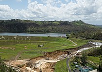
[edit]On September 22, 2017, at 18:10 GMT, following Hurricane Maria, operators at Guajataca Dam announced that the dam's spillway was failing at the northern end of the lake and it could result in the whole dam collapsing.[17] The National Weather Service a few minutes later urged all 70,000 residents in the flood area to be evacuated. The National Weather Service stated the dam was a "life-threatening situation".[18][19][20] "It’s a structural failure. I don’t have any more details," Governor Ricardo Rosselló stated. "We’re trying to evacuate as many people as possible."[20] Rosselló ordered the Puerto Rico National Guard and the Police to help assist in the evacuation effort downstream.[21] The dam lies across the Guajataca River to form a reservoir that can hold roughly 11 billion gallons of water.[22]
As of September 2017[update], the dam was last inspected on October 23, 2013.[12]
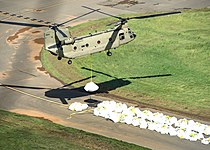
The first phase of repairs to avoid the threat of flooding were completed on November 17, 2017. Since then about 10,000 residents, including farmers, who depend on the waters of the reservoir, have been struggling with the rationing of water. There is confusion and little transparency as to how the issue is being handled. Final repairs will be ongoing, until 2028.[23][24]
Gallery
[edit]-
 Lake Guajataca in San Sebastián
 -
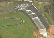 Damaged spillway, September 27
 -
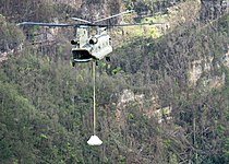
 Pennsylvania National Guard working to stabilize the structure
 -
 A Chinook lifting a big sandbag to reinforce the spillway, October 9
 -
 Pennsylvania National Guard
 -
 USACE and Pennsylvania National Guard working to stabilize the structure, October 9


See also
[edit]References
[edit]- ^ Jump up to: a b c d Luis R. Soler-López1 (2001). "SEDIMENTATION SURVEY RESULTS of the Principal Water-Supply Reservoirs of Puerto Rico". pr.water.usgs.gov. U.S. Geological Survey. USGS Water Resources of the Caribbean. TABLE 1. Results of bathymetric surveys of 14 reservoirs in Puerto Rico. Retrieved 2017-09-22.
{{cite web}}: CS1 maint: numeric names: authors list (link) - ^ Jump up to: a b Puerto Rico Dam Failing; Flash Flood Emergency Declared: "This is an EXTREMELY DANGEROUS SITUATION," NWS San Juan said in a tweet. Asher Klein. NBC10-TV. Philadelphia, Pennsylvania, USA. 22 September 2017. Access 22 September 2017.
- ^ Jump up to: a b "Lake Guajataca". Atlas Obscura. Retrieved 2021-12-30.
- ^ "Lago Guajataca". pr.gov - Quebradillas. Archived from the original on 2021-12-30. Retrieved 2021-12-30.
- ^ "Un pasadía en... Lago Guajataca". Primera Hora. July 2015. Retrieved 2021-12-30.
- ^ "Refugio Vida Silvestre, Embalse Guajataca". Discover Puerto Rico. Retrieved 2021-12-30.
- ^ "Lago Guajataca". 3 May 2013. Retrieved 2022-02-10.
- ^ Jump up to: a b "Lago Guajataca at Damsite". Water Resources of the Caribbean. United States Geological Survey. Retrieved September 22, 2017.
- ^ Ellis, Ralph (22 September 2017). "Puerto Rico dam: Evacuations begin along Guajataca River". CNN. CNN News. Retrieved September 22, 2017.
- ^ Schmidt, Samantha. "'Thousands of people could die': 70,000 in Puerto Rico urged to evacuate with dam in 'imminent' danger". Washington Post. Retrieved September 23, 2017.
- ^ "El embalse Guajataca entraría en nivel de ajustes operacionales este jueves o viernes". 22 June 2022.
- ^ Jump up to: a b c d e f g h GUAJATACA DAM: NID Detail Report
- ^ "Fotografias de Plantas Hidroelectricas en el 2013". Recursos Agua Puerto Rico. Retrieved 2021-12-30.
- ^ Jump up to: a b c Pantoja-Agreda, Fernando; Martínez, Gustavo A.; Santos-Flores, Carlos; Sotomayor-Ramírez, David (2009-01-01). "Phytoplankton dynamics of the Guajataca reservoir, Puerto Rico". Sil Proceedings, 1922-2010. 30 (7): 1096–1100. Bibcode:2009SILP...30.1096P. doi:10.1080/03680770.2009.11902310. ISSN 0368-0770. S2CID 134913442.
- ^ "National Pollutant Discharge Elimination System (NPDES) Phase II, Regulated Small Municipal Separate Storm Sewer System (MS4's) Permit Application Notice of Intent (NOI)" (PDF). U.S. Environmental Protection Agency- Region II. January 2010: 8. Retrieved 23 September 2017.
{{cite journal}}: Cite journal requires|journal=(help) This article incorporates text from this source, which is in the public domain.
- ^ Reily, Emmet Montgomery, Governor of Puerto Rico (1922). Annual Report. U.S. Government Printing Office. pp. 233–234.
{{cite book}}: CS1 maint: multiple names: authors list (link) - ^ "Aid reaches Puerto Rico after Maria as threat from cracked dam recedes". The Guardian. 24 September 2017. Retrieved September 26, 2017.
- ^ "Guajataca Dam fails in Puerto Rico, prompting "extremely dangerous" situation". CBS News. Retrieved September 22, 2017.
- ^ "Puerto Rico dam failure "imminent" after Hurricane Maria". BBC World News. BBC News. 22 September 2017. Retrieved September 22, 2017.
- ^ Jump up to: a b "Puerto Rico evacuates 70,000 after dam fails in Hurricane Maria's wake". The Guardian. 22 September 2017. Retrieved September 22, 2017.
- ^ Talmazan, Yuliya (23 September 2017). "Puerto Rico's Failing Guajataca Dam Endangers Thousands". NBC News. Retrieved September 23, 2017.
- ^ "Damage Assessments, Power Restoration Efforts Begin in Puerto Rico, Virgin Islands". The Weather Channel. Retrieved 2017-09-25.
- ^ "Government of Puerto Rico Drained the Guajataca Dam at the Height of the Drought". 24 April 2019.
- ^ "Drying Caribbean | Centro de Periodismo InvestigativoCentro de Periodismo Investigativo".
- Pantoja-Agreda, Fernando; Martínez, Gustavo A.; Santos-Flores, Carlos; Sotomayor-Ramírez, David (2009-01-01). "Phytoplankton dynamics of the Guajataca reservoir, Puerto Rico". Sil Proceedings, 1922-2010. 30 (7): 1096–1100. Bibcode:2009SILP...30.1096P. doi:10.1080/03680770.2009.11902310. ISSN 0368-0770. S2CID 134913442.
| International | |
|---|---|
| National | |