Озургети муниципалитет

Озургети муниципалитет
Озургети муниципалитет | |
|---|---|
 Школа в Озургети | |
 Флаг  Тюлень | |
 Location of the municipality within Georgia | |
| Coordinates: 41°56′00″N 41°59′00″E / 41.9333°N 41.9833°E | |
| Country | |
| Region | Guria |
| Capital | Ozurgeti |
| Government | |
| • Type | Mayor–Council |
| • Body | Ozurgeti Municipal Assembly |
| • mayor | Avtandil Talakvadze (GD)[1] |
| Area | |
| • Total | 675 km2 (261 sq mi) |
| Population (2021) | |
| • Total | 59,357 |
| • Density | 87.9/km2 (228/sq mi) |
| Population by ethnicity[2] | |
| • Georgians | 97.19 % |
| • Armenians | 1.77 % |
| • Russians | 0.59 % |
| • Ukrainians | 0.17 % |
| Time zone | UTC+4 (Georgian Standard Time) |
| Area code | +995 496 |
| Website | ozurgeti |

Озургети ( Грузинец : Муниципалитет Озургети , Озургетис Мунитспалит ) - муниципалитет Грузии , в регионе Гурии . Его главный город - Озургети .
Муниципалитет Озургети расположен на территории Западной Грузии. Его площадь 675 км 2 (261 кв. Миль). Муниципалитет Одзургети граничит на западе Черным морем , на юге хребтом Адбара-Гурия, рекой Чолоки и Автономной Республикой Аджрара ; Муниципалитеты Чокхатаури на востоке и муниципалитеты Ланчхути на севере. Черные земля-аллювиальные и глиняные почвы распространяются на территории муниципалитета. Переводы красной земли распространяются в холмистой полосе муниципалитета. Красные сплавы аллювиального вторичного происхождения разрабатываются на террасах рек, отложений и болот, а болотистые почвы разрабатываются в прибрежной зоне. [ 3 ]
История
[ редактировать ]Until 1917, the territory of the municipality was included in Ozurgeti Mazra of Kutaisi Province, in 1930 it was formed as a separate territorial unit and was called Ozurgeti District. In 1934, the Makharadze district was renamed in honor of Philip Makharadze. In the early 1960s, the area of the district was reduced: part of the area near Gomismti was transferred to Kobuleti district, and part of the area around the river Supsa to Lanchkhuti district. In 1963–64, Chokhatauri district joined Makharadze district and the city of Makharadze was defined as the center. In 1990, the district was renamed Ozurgeti, and since 2006 - Ozurgeti Municipality. Between 2014 and 2017 the city of Ozurgeti, like others, was separated from the municipality and was a so-called "self-governed" city (or kalaki).[4]
Geography
[edit]The territory of the municipality is flooded with rivers and valleys, the rivers belong to the Black Sea basin. The river Supsa flows in the territory of the municipality, to which the river Bakhvistskali joins the territory of the municipality. Also important are the sediments with tributaries: Bzhuzhi, Choloki, Bogila, and others. The rivers of the municipality are fed by lanyards, rains, soil water, and springs. At the confluence of the seas, they contribute to the marshes of the lowlands. The river Choloki separates Ozurgeti municipality from the territory of Kobuleti municipality. The rivers are rich in fish. Found in trout, barbel, salmon, sorrel. The highest points of the territory of the municipality are in the south-eastern part of its border. Here are the highest peaks of the municipality: Mount Sakornia (2,756 m [9,042 ft].) And Gunistavi (2,132 m [6,995 ft]). The south-western part of the municipality is a plain, which is a floodplain of the river Natanebi, with an average height of 20 metres (66 ft) above sea level. Achi water gorge North of Vake is the southwestern end of the Guria Mountains, where the average altitude is 120 metres (390 ft) above sea level. It is located here near Mount Jacob, which is 145 metres (476 ft) high.[5]
Climate
[edit]The climate is characterized by a subtropical humid climate. Humidity is due to the proximity of the Black Sea and high ridges to the east. Humidity is especially high in summer. The average annual rainfall is 2,100 to 2,800 mm (83 to 110 in). The maximum precipitation falls in September, the minimum - in May. The average annual air temperature is 14.5 to −4 °C (58.1 to 24.8 °F), the coldest month is January (+5 to −5 °C [41 to 23 °F]), and the warmest is August (23 to 13 °C [73 to 55 °F]). The absolute minimum temperatures are −17 to −18 °C (1 to 0 °F) (coastal lowlands) and −30 to −32 °C (−22 to −26 °F) (high mountains). The absolute maximum ranges between 31 and 41 °C. The territory of the municipality is characterized by seasonal winds: south-east winds in winter and west winds in summer. The average wind speed is 3.2 m/s (10 ft/s). Knows fions in winter and spring, though they do less harm; Than in other parts of western Georgia. The territory of the municipality is in the 5-6 magnitude zone in terms of earthquake danger.[6]
Biodiversity
[edit]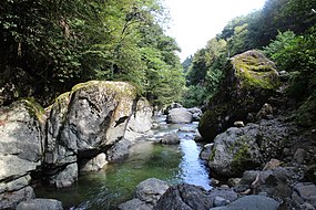
The forest occupies 17,021 hectares (42,060 acres) on the territory of the municipality. The vegetation is formed by chestnut, hornbeam, beech, dried fruit, in the form of undergrowth can be found blueberries, sage, watercress. Natural forests are preserved in the south-eastern highlands of the municipality. At 700 to 1,700 m (2,300 to 5,600 ft) above sea level, there is a deciduous forest (alder, hornbeam, beech), and at 1,700 to 2,100 m (5,600 to 6,900 ft) there is a coniferous forest (pine, fir, spruce). Bears, roe deer, marten, tortoises, lynxes, squirrels, wolves, ticks, hedgehogs, badgers, rabbits, rabbits are common in the forests. Among the birds common are dzera, kvavi, orbi, thrush, chkhartvi, wild duck, swamp hen, niblia, kodala, tavshava, heartworm, hawk. Migratory birds enter in spring: ghazo, jadon, quail, hoopoe, mullet.
Politics
[edit]Ozurgeti Municipal Assembly (Georgian: ოზურგეთის საკრებულო, Ozurgeti Sakrebulo) is a representative body in Ozurgeti Municipality, consisting of 45 members and elected every four years. The last election was held in October 2021.
| Party | 2017[7] | 2021[8] | Current Municipal Assembly | |||||||||||||||||||||||||||||||||||||||||||||
|---|---|---|---|---|---|---|---|---|---|---|---|---|---|---|---|---|---|---|---|---|---|---|---|---|---|---|---|---|---|---|---|---|---|---|---|---|---|---|---|---|---|---|---|---|---|---|---|---|
| Georgian Dream | 36 | 30 | ||||||||||||||||||||||||||||||||||||||||||||||
| United National Movement | 4 | 11 | ||||||||||||||||||||||||||||||||||||||||||||||
| For Georgia | 4 | |||||||||||||||||||||||||||||||||||||||||||||||
| Alliance of Patriots | 2 | |||||||||||||||||||||||||||||||||||||||||||||||
| European Georgia | 1 | |||||||||||||||||||||||||||||||||||||||||||||||
| Labour Party | 1 | |||||||||||||||||||||||||||||||||||||||||||||||
| Independent | 2 | |||||||||||||||||||||||||||||||||||||||||||||||
| Total | 46 | 45 | ||||||||||||||||||||||||||||||||||||||||||||||
Population
[edit]
By the start of 2021 the population was determined at 59,357 people,[9] a decline compared to the 2014 census.[11] There are 75 settlements in the municipality: 1 city, 4 urban-type settlements (daba) and 70 villages. The density is 87.9 inhabitants per square kilometre (228/sq mi).
97% of the residents are Georgians, mainly Gurians, as well as Adjarans. There are also Armenians (2%) and Russians (1%). The vast majority of the population is Orthodox Christian, a small portion is Muslim, and there are small groups of other religious denominations living in the municipality, such as Catholics, Protestants and Jehovah's Witnesses.
| Population Ozurgeti Municipality | ||||||||||||||||||
|---|---|---|---|---|---|---|---|---|---|---|---|---|---|---|---|---|---|---|
| 1897 | 1922 | 1926 | 1939 | 1959 | 1970 | 1979 | 1989 | 2002[12] | 2014 | 2021 | ||||||||
| Ozurgeti Municipality | - | - | - | - | 75,240 | [11] |
||||||||||||
| Ozurgeti | 4,710 | |||||||||||||||||
| Laituri (daba) | - | - | - | - | 5,018 | |||||||||||||
| Naruja (daba) | - | - | - | - | - | - | - | 2,219 | ||||||||||
| Kveda Nasakirali (daba) | - | - | - | - | - | - | 2,290 | |||||||||||
| Ureki (daba) | - | - | - | - | 1,736 | |||||||||||||
| Data: Population statistics Georgia 1897 to present.[13][14] Note:[12] | ||||||||||||||||||
Historical sites
[edit]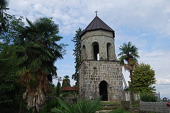
The oldest historical monument on the territory of the municipality is the town of Vashnari. There are two castles on the territory of the municipality and both are named after Queen Tamar. These are the castles of Askani and Likhauri. Askani Castle Among the medieval church buildings are the Church of the Creator, which is the center of the Diocese of the Creator, and the Church of Jumat, which was the historic center of the Diocese of Jumat. Important monuments are the churches of Achi, Likhauri, and Baileti, where rare frescoes are preserved. In addition, hall and basilica type churches are located in Dvabzu, Vaniskedi, Kviriketi, Meria, Mtispiri, Konchkati and Khrialeti.[16]
Historical sites include:
Resorts and tourism
[edit]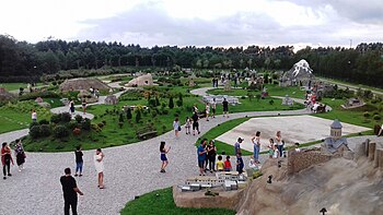
Ozurgeti Municipality has unique resorts both on the seaside and in the alpine zone. Of the four recreational status resorts in Georgia, Ureki is located in the municipality. The resorts of the municipality allow to host tourists from Georgia or abroad in winter and summer, which is one of the main preconditions for budget growth and employment of the population. Ureki, Shekvetili and Gomismta mountain resort are among the seaside resorts of the municipality.[17]
Resorts and Tourist sites include:
- Ureki
- Shekvetili
- Nasakirali
- Black Sea Arena
- Ozurgeti Drama Theatre
- Ozurgeti History Museum
- Шекветили миниатюрный парк
- ДИМИТРИ ГУРИЛИ Дворец
Города -близнецы - Сестринские города
[ редактировать ]Смотрите также
[ редактировать ]- Список муниципалитетов в Грузии (страна)
- В стороне , деревня в Озурред
- Чаниетери , деревня в Озургети
- Гагма Двабзу , деревня в Озургети
- Vashtiali , деревня в Озургети
- Ее, Озургер в никулите , деревня
- Zeda dzimiti , деревня
Ссылки
[ редактировать ]- ^ «Автандил Талаквадзе начал действовать как мэр» (на Грузии). 2021-11-22 . Получено 2022-01-06 .
- ^ «Этнический состав Грузии 2014» . Статистика населения Восточная Европа и бывший СССР . Получено 2022-01-06 .
- ^ «Основные данные муниципалитета» .
- ^ «Парламент уменьшает количество городов самоуправления» .
- ^ «Основные данные муниципалитета» .
- ^ «Основные данные муниципалитета» .
- ^ «Протокол избрал члены муниципального совета и мэры 2017 года» (PDF) (на грузинском языке). Центральная избирательная комиссия Ческо. п. 74-76 . Получено 2021-01-06 .
- ^ «Протокол избрал члены муниципального совета и мэров 2021» (PDF) (на грузинском языке). Центральная избирательная комиссия Ческо. п. 92-94 . Получено 2021-01-06 .
- ^ «Население и демография - население по городам и районам (Даба), по состоянию на 1 января» . Национальное статистическое управление Грузии, Геостат . 2021-01-01 . Получено 2022-01-03 .
- ^ «Основные результаты переписи 2014 года (публикация)» (PDF) . CENSUS.GE, Национальное статистическое управление Грузии (GEOSTAT) (у грузинского). 2016-04-28. С. 49–50, 56–61 . Получено 2022-01-06 .
- ^ Подпрыгнуть до: а беременный Комбинированные фигуры городского муниципалитета (Калаки) Озургети и муниципалитет Озургети. [ 10 ]
- ^ Подпрыгнуть до: а беременный Перепись 2014 года обнаружила необъяснимый пробел с данными Геостата Национального статистического управления. Несоответствующие исследования показали, что перепись 2002 года была раздувана примерно на 8-9 процентов. Видеть, [ 15 ] «1. Введение», стр. 1.
- ^ «Отделение населения Грузии» . Статистика населения Восточная Европа и бывший СССР . Получено 2022-01-06 .
- ^ «Городские города и города Грузия» . Статистика населения Восточная Европа и бывший СССР . Получено 2022-01-06 .
- ^ «Динамика населения в Грузии - обзор, основанный на данных переписи населения 2014 года» (PDF) . Национальное статистическое управление Грузии, Геостат . 2017-11-29 . Получено 2022-01-01 .
- ^ «История, достопримечательности» .
- ^ «История, достопримечательности» .
- ^ «Города -близнецы» . Guria.gov.ge (на грузинском языке). Гурия регион . Получено 2020-02-15 .
- ^ «Скорочные города» . Istoboyarka.gov.ua (на украинском языке). Боярка . Получено 2020-03-30 .
Внешние ссылки
[ редактировать ]- Районы Грузии , Statoids.com