Tam Kỳ

You can help expand this article with text translated from the corresponding article in Vietnamese. (October 2023) Click [show] for important translation instructions. |
Tam Kỳ
Thành phố Tam Kỳ | |
|---|---|
| Tam Kỳ City | |
 | |
 | |
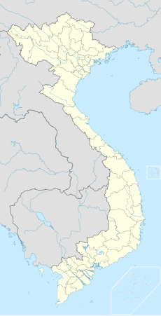 Tam Kỳ Location of in Vietnam | |
| Coordinates: 15°34′N 108°29′E / 15.567°N 108.483°E | |
| Country | |
| Province | Quảng Nam Province |
| Founded |
|
| Government | |
| • Chairman of the People's Committee | Bùi Ngọc Ảnh |
| • Chairman of the People's Council | Nguyễn Hồng Quang |
| • Chairman of the Fatherland Front | Phạm Hoàng Đức |
| Area | |
| • City (Class-2) | 100.26 km2 (38.71 sq mi) |
| Population (2019 census) | |
| • City (Class-2) | 122,374 |
| • Density | 1,200/km2 (3,200/sq mi) |
| • Urban | 91,450 people (75%) |
| Time zone | UTC+7 (Indochina Time) |
| Climate | Am |
| Website | tamky |

Tam Kỳ () (IATA: TMK) is the capital city of Quảng Nam Province, in the South Central Coast of Vietnam. As of 2019 the city had a population of 122,374.[1]
History
[edit]
The town was established in 1906 under the Nguyễn dynasty as an administrative and tax post.[2] During the Republic of Vietnam, the city was the main base of the US military in Quảng Nam Province (what was then Quảng Tín Province) for the war in Vietnam. The North Vietnamese captured the city on March 24, 1975.
In 1997, the local government under the Socialist Republic of Vietnam made it the capital of Quảng Nam province.[3]
Since then, there has been substantial development within the city. Tam Kỳ city is famous for Tam Kỳ chicken rice, which is recognized nationally, and many pristine beaches. In addition, Tam Kỳ city is also famous for Tam Kỳ noodles, which is known as My Quang.
Climate
[edit]| Climate data for Tam Kỳ | |||||||||||||
|---|---|---|---|---|---|---|---|---|---|---|---|---|---|
| Month | Jan | Feb | Mar | Apr | May | Jun | Jul | Aug | Sep | Oct | Nov | Dec | Year |
| Record high °C (°F) | 32.6 (90.7) |
35.9 (96.6) |
37.0 (98.6) |
40.8 (105.4) |
41.0 (105.8) |
40.2 (104.4) |
41.0 (105.8) |
41.0 (105.8) |
38.7 (101.7) |
37.7 (99.9) |
32.4 (90.3) |
30.7 (87.3) |
41.0 (105.8) |
| Mean daily maximum °C (°F) | 24.7 (76.5) |
26.4 (79.5) |
28.9 (84.0) |
31.7 (89.1) |
33.5 (92.3) |
34.4 (93.9) |
34.2 (93.6) |
33.9 (93.0) |
31.6 (88.9) |
29.0 (84.2) |
27.0 (80.6) |
24.6 (76.3) |
30.0 (86.0) |
| Daily mean °C (°F) | 21.5 (70.7) |
22.5 (72.5) |
24.4 (75.9) |
26.8 (80.2) |
28.3 (82.9) |
29.1 (84.4) |
28.9 (84.0) |
28.6 (83.5) |
27.3 (81.1) |
25.6 (78.1) |
24.1 (75.4) |
21.9 (71.4) |
25.7 (78.3) |
| Mean daily minimum °C (°F) | 19.4 (66.9) |
20.2 (68.4) |
21.6 (70.9) |
23.7 (74.7) |
24.9 (76.8) |
25.5 (77.9) |
25.3 (77.5) |
25.2 (77.4) |
24.4 (75.9) |
23.4 (74.1) |
22.1 (71.8) |
20.1 (68.2) |
23.0 (73.4) |
| Record low °C (°F) | 12.3 (54.1) |
14.4 (57.9) |
14.2 (57.6) |
18.2 (64.8) |
20.6 (69.1) |
22.4 (72.3) |
21.3 (70.3) |
19.8 (67.6) |
20.6 (69.1) |
17.6 (63.7) |
14.8 (58.6) |
12.0 (53.6) |
12.0 (53.6) |
| Average rainfall mm (inches) | 127.9 (5.04) |
48.7 (1.92) |
52.6 (2.07) |
54.1 (2.13) |
96.5 (3.80) |
97.9 (3.85) |
88.9 (3.50) |
131.0 (5.16) |
336.4 (13.24) |
704.1 (27.72) |
622.6 (24.51) |
388.1 (15.28) |
2,748.8 (108.22) |
| Average rainy days | 15.5 | 7.8 | 6.1 | 5.8 | 9.4 | 8.0 | 8.2 | 10.7 | 15.2 | 20.7 | 21.6 | 21.4 | 150.4 |
| Average relative humidity (%) | 88.6 | 87.7 | 85.9 | 83.4 | 80.2 | 78.1 | 77.9 | 79.0 | 84.4 | 87.5 | 88.8 | 89.6 | 84.3 |
| Mean monthly sunshine hours | 116.0 | 142.6 | 192.7 | 215.7 | 248.2 | 236.2 | 234.5 | 220.6 | 184.7 | 145.8 | 105.7 | 75.8 | 2,128 |
| Source: Vietnam Institute for Building Science and Technology[4] | |||||||||||||
Transportation
[edit]The city is served by Tam Kỳ Railway Station, which is connected to all major cities across Vietnam. Da Nang International Airport is 70 km from the city, which is a one and a half hours' drive. The closer Chu Lai International Airport is 30 km away. There is a free daily shuttle bus between the airport and Quảng Ngãi city center. Other means of transportation include regular car and bus services.
Notable people
[edit]- Julie Yip-Williams (1976-2018), American lawyer, memoirist, born in Tam Kỳ.
Gallery
[edit]-
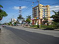 Streets in Tam Kỳ, Quảng Nam
 -
 Tam Kỳ River, Quảng Nam
 -
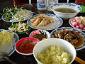 Cơm gà Tam Kỳ, Tam Ky chicken rice


References
[edit]- ^ "Tam Kỳ (District-level City, Quảng Nam, Vietnam) - Population Statistics, Charts, Map and Location". www.citypopulation.de. Retrieved 2024-02-07.
- ^ Bradley Camp Davis States of Banditry: The Nguyễn Government, Bandit Rule, and the culture of power in the post-Taiping China-Vietnam Borderlands 2008 Page 106 "unspecified bandits ransacked two tax posts, including Tam Kỳ ... Tam Kỳ returned steady revenue"
- ^ baoquangnam.vn (2016-08-23). "Tam Kỳ - từ ký ức đến hiện tại". baoquangnam.vn (in Vietnamese). Retrieved 2024-05-18.
- ^ "Vietnam Institute for Building Science and Technology" (PDF).
External links
[edit]Places adjacent to Tam Kỳ |
|---|

15°34′N 108°29′E / 15.567°N 108.483°E
This article about a location in Quảng Nam Province, Vietnam is a stub. You can help Wikipedia by expanding it. |