Река Блэкуотер (Западная Вирджиния)

| Река Блэкуотер | |
|---|---|
 Река Блэкуотер в Блэкуотере Каньон, вид с Линди -Пойнт в Государственном парке Блэкуотер -Фолс | |
 Map of the Monongahela River basin, with the Blackwater River highlighted. | |
| Location | |
| Country | United States |
| State | West Virginia |
| County | Tucker |
| Physical characteristics | |
| Source | Canaan Mountain |
| • location | Tucker County, WV |
| • coordinates | 39°03′39″N 79°29′04″W / 39.06083°N 79.48444°W[1] |
| • elevation | 3,594 ft (1,095 m)[2] |
| Mouth | Black Fork |
• location | Hendricks, WV |
• coordinates | 39°04′20″N 79°37′45″W / 39.07222°N 79.62917°W |
• elevation | 1,690 ft (520 m)[1] |
| Length | 34 mi (55 km) |
| Basin size | 142 sq mi (370 km2) |
| Discharge | |
| • location | Davis, WV[3] |
| • average | 189 cu ft/s (5.4 m3/s)[3] |
| • minimum | 22 cu ft/s (0.62 m3/s)(1930) |
| • maximum | 12,500 cu ft/s (350 m3/s)(1929) |
| Basin features | |
| Tributaries | |
| • right | North Branch Blackwater River, Little Blackwater River |
Река Блэкуотер длиной 34,3 мили (55,2 км) представляет собой реку [ 4 ] в горах Аллегейни Восточной Западной Вирджинии , США. , Черная вилка это основной приток Чит -Ривер . Чит, Мононгахела и реки Огайо , это часть водораздела реки Миссисипи и разворачивает площадь 142 квадратных миль (370 км 2 ) Это настоящий поток Blackwater , из -за ели и болиговых деревьев в его водоразделе, танины, которые придают чай или янтарный цвет его воде. [ 5 ]
География
[ редактировать ]Весь курс и зона дренажа Блэкуотера лежат в округе Такер . [ 6 ] Он поднимается на горе Ханаан на высоте 3594 футов (1095 м) [ 1 ] и первоначально извинится на северо-северо-восток через водно-болотные угодья долины Ханаан , проходя через Государственный парк курорта Ханаанской долины и национальное убежище на национальном уровне дикой природы в Ханаанской долине , [6] and collecting two short tributaries known as the North Branch Blackwater River[7] and the Little Blackwater River.[8] Below the mouth of the latter, the Blackwater turns west-southwestwardly for the remainder of its course.[6]
After passing the town of Davis, it falls 62 feet (19 m) over Blackwater Falls and enters the eight-mile (13 km) long Blackwater Canyon in Blackwater Falls State Park.[9] Here it forms whitewater rapids of Class IV-V+[10] and collects the eight-mile (13 km) long North Fork Blackwater River,[11] which flows past the town of Thomas.[1]
Finally, the Blackwater joins the Dry Fork to form the Black Fork at the town of Hendricks,[6] at an elevation of 1,690 feet (520 m).[1]
Water quality
[edit]Blackwater
[edit]As with other blackwater rivers, the color of West Virginia's Blackwater River results from the leaching of tannins from the decaying leaves of vegetation adjoining the stream in its upper reaches, which are slow moving. Fallen needles from stands of eastern hemlock and red spruce contribute primarily to this, although rhododendron, mountain laurel and the sphagnum bogs of Canaan Valley also contribute.[citation needed] The Blackwater is also typical in having transparent, acidic, and oligotrophic (very low nutrient) water.
Acid mine drainage
[edit]Beginning in the 1880s,[citation needed] the Blackwater River watershed (especially the segment of the North Fork of the Blackwater River between the towns of Thomas and Douglas) suffered extreme environmental degradation due to deep mining and coke production. This was exacerbated by the surface mining activities of the 1960s and '70s,[citation needed] which brought about a severe decline in water quality due to acid mine drainage (AMD).
In recent years, the limestone treatment of AMD in the Blackwater River has met with success with the effort receiving an award from the U.S. Office of Surface Mining.[12] AMD is created when sulfite-bearing mineral strata are exposed to air and rainwater, such as when surface mining occurs. The sulfuric acid produced from the sulfite reaction can dissolve metals such as iron, aluminum, and magnesium.[13] By 2004, the combination of acid and dissolved metals drainage had destroyed or damaged about 12,000 miles (19,000 km) of streams in Appalachia,[14] including the Blackwater River and streams in its watershed.
Restoration of the Blackwater River watershed was a costly[15][16] and complex task involving two large projects. The Douglas Highwall Abandoned Mine Land Reclamation Project installed 16,000 tons (14,400 tonnes) of limestone in a "Wetland/Anoxic Limestone Drain (WALD) system"[15] on the North Fork Blackwater River downstream of Thomas. Although the experimental WALD system did not perform as intended, and "has not generated measurable alkalinity"[15] it did reduce the total acid and metal load in the water discharge from the abandoned mine into the river system.
More successful was a project just upstream of Davis, on Beaver Creek, a tributary of the Blackwater.[17] A six-drum water-powered limestone grinding station adds limestone slurry to the water flowing down Beaver Creek. A Swedish-designed limestone powder dosing system was also installed as backup to the drum system.[16] The five miles (8.0 km) stretch of the Blackwater between the limestone station and the confluence with the North Fork has now become one of West Virginia's premiere catch and release trout streams.[18]
Gallery
[edit]-
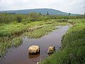 Upper reaches of the Blackwater River in the wetlands of Canaan Valley Resort State Park
 -
 The Blackwater River near where it crosses into Blackwater Falls State Park
 -
 Blackwater Falls drops about 62' in Blackwater Falls State Park
 -
 Blackwater River Gorge viewed from the lodge in Blackwater Falls State Park
 -
 Confluence with Dry Fork to form Black Fork
 -
 North Fork Blackwater River in Thomas
 -
 Douglas Falls (North Fork Falls), a drop of about 35' on the North Fork Blackwater River


River water level
[edit]Two real time water gauges are available from the United States Geological Survey:
- Blackwater River real time water gauge, 2.8 miles northeast of Davis, West Virginia
- Blackwater River real time water gauge, 0.4 miles southwest of Davis, West Virginia
See also
[edit]References
[edit]- ^ Jump up to: a b c d e "Blackwater River". Geographic Names Information System. United States Geological Survey, United States Department of the Interior. Retrieved 2008-05-30.
- ^ "Blackwater River Source". Elevation Query. U.S. Geological Survey. Archived from the original on March 1, 2012. Retrieved May 27, 2010.
- ^ Jump up to: a b "USGS 03066000 BLACKWATER R AT DAVIS, WV". U.S. Geological Survey. Retrieved 2008-05-30.
- ^ U.S. Geological Survey. National Hydrography Dataset high-resolution flowline data. The National Map Archived 2012-03-29 at the Wayback Machine, accessed August 15, 2011
- ^ Hissom, Patricia. 2006. "Blackwater River." The West Virginia Encyclopedia. Ken Sullivan, editor. Charleston, WV: West Virginia Humanities Council. ISBN 0-9778498-0-5.
- ^ Jump up to: a b c d DeLorme (1997). West Virginia Atlas & Gazetteer. Yarmouth, Maine: DeLorme. ISBN 0-89933-246-3.
- ^ U.S. Geological Survey Geographic Names Information System: North Branch Blackwater River
- ^ U.S. Geological Survey Geographic Names Information System: Little Blackwater River
- ^ Kennedy-Venable, Norma Jean. 2006. "Blackwater Falls." The West Virginia Encyclopedia. Ken Sullivan, editor. Charleston, WV: West Virginia Humanities Council. ISBN 0-9778498-0-5.
- ^ American Whitewater report on lower Blackwater River
- ^ U.S. Geological Survey Geographic Names Information System: North Fork Blackwater River
- ^ U.S. Office of Surface Mining 1999 Award web page, accessed August 26, 2006
- ^ "Sibrell, P.L., Barnaby J. Watten, B.J., Friedrich, A.E, and Vinci, B.J., ARD Remediation with Limestone in a CO2 Pressurized Reactor, 5th International Conference on Acid Rock Drainage, Denver, Colorado, May, 2000" (PDF). Archived from the original (PDF) on 2008-09-16. Retrieved 2006-08-27.
- ^ Williams, T., "Coal Country Trout", Fly Rod & Reel Magazine, July/October 2004. Archived October 17, 2006, at the Wayback Machine
- ^ Jump up to: a b c Skousen, J., Gorman, J., and Ziemkiewicz, P., Long Term Effects of Acid Mine Drainage Remediation Projects on Stream Quality, Proceedings Twentieth Annual West Virginia Surface Mine Drainage Task Force Symposium, Morgantown, WV, April 13-14, 1999. Archived May 10, 2006, at the Wayback Machine
- ^ Jump up to: a b Zurbuch, P.E., Early Results from Calcium Carbonate Neutralization of Two West Virginia Rivers Acidified by Mine Drainage, Seventeenth Annual West Virginia Surface Mine Drainage Task Force Symposium, Morgantown, WV, April 2-3, 1996. Archived May 10, 2006, at the Wayback Machine
- ^ Mineral Information Institute web site, accessed August 26, 2006. Archived October 4, 2006, at the Wayback Machine
- ^ West Virginia Department of Natural Resources Special Fishing Regulations web page, accessed August 27, 2006. Archived August 23, 2006, at the Wayback Machine
External links
[edit]| Базы данных управления авторитетом : национальный |
|---|