Часовня-ле-Дейл

| Часовня-ле-Дейл | |
|---|---|
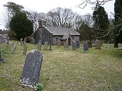 Святой Леонардс Церковь | |
 Часовня-ле-Дейл Расположение в Северном Йоркшире | |
| Ссылка на сетку ОС | SD739769 |
| Unitary authority | |
| Ceremonial county | |
| Region | |
| Country | England |
| Sovereign state | United Kingdom |
| Post town | Carnforth |
| Postcode district | LA6 |
| Police | North Yorkshire |
| Fire | North Yorkshire |
| Ambulance | Yorkshire |
| UK Parliament | |
Чапел-ле-Дейл -это деревушка в гражданском приходе Инглтона , Северный Йоркшир , Англия. Он находится в национальном парке Йоркшир -Дейлс долине в одноименной , и ранее находился в западном езде в Йоркшире .
История
[ редактировать ]Гамлет расположена на дороге B6255 между Инглтоном и Риблхедом рядом с виадуком Риблхеда . Название происходит от старого французского и буквально означает часовню в долине . [ 1 ] Впервые он был записан как Chappell Ith Dale в 1677 году. [ 2 ] Исторически, Гамлет и его приход находились в , так ваентоке Эукросса и вплоть до 1974 года они находились на западе в Йоркшире. [ 3 ] [ 4 ] В 1892 году Гамлет была зарегистрирована как население 150 лет. Современная статистика населения зарегистрирована в гражданском округе Инглтона. [ 5 ] [ 6 ]
Гамлет находится в непосредственной близости от Инглборо и Уорнсайда , и в окрестностях есть несколько выбоинов, [ 7 ] Самый известный - отличная пещера Дука . В деревне есть паб, Old Hill Hill Inn , который используется в качестве стартовой и конечной точки для различных прогулок по Уорнсайду или Инглборо. [8] Источник реки Доу находится рядом.
There is a church in the hamlet (The Church of St Leonard) which is now a grade II listed building. It was used as a burial plot for the navvies, and their family members, who died whilst constructing the nearby Ribblehead Viaduct between 1869 and 1876. In all, over 200 people died during the construction from accidents and outbreaks of smallpox. A plaque was erected in the church to their memory.[9][10][11] Previous to the railway's construction, deaths and burials in the dale numbered between two and four people each year on average. A survey of the parish records from 1876 showed the average of 44 burials per year between 1870 and 1875.[12]
References
[edit]- ^ Chrystal, Paul (2017). The Place Names of Yorkshire. Catrine: Stenlake. p. 25. ISBN 9781840337532.
- ^ "Archaeological survey in Chapel-le-Dale, North Yorkshire" (PDF). outofoblivion.org.uk. The Brigantia Archaeological Practice. June 2001. p. 10. Retrieved 2 January 2018.
- ^ "Genuki: In 1822, the following places were in the Parish of Low Bentham:, Yorkshire (West Riding)". www.genuki.org.uk. Retrieved 2 January 2018.
- ^ "History of Chapel le Dale, in Craven and West Riding | Map and description". www.visionofbritain.org.uk. Retrieved 2 January 2018.
- ^ Speight, Harry (1892). The Craven and North-west Yorkshire Highlands. London: Elliot Stock. p. 245. OCLC 7219082.
- ^ UK Census (2011). "Local Area Report – Ingleton Parish (E04007098)". Nomis. Office for National Statistics. Retrieved 14 July 2023.
- ^ Buckley, Norman (1995). Yorkshire Dales walking : on the level (3 ed.). Wilmslow: Sigma Leisure. p. 65. ISBN 1-85058-439-7.
- ^ Upton, Hannah (20 February 2013). "REVIEW: Old Hill Inn, Chapel-le-Dale". The Westmorland Gazette. Retrieved 2 January 2018.
- ^ Moore, Lindsey (20 November 2014). "Life and death on the Settle-Carlisle". Craven Herald. Retrieved 2 January 2018.
- ^ Historic England. "Church of St Leonard (Grade II) (1213046)". National Heritage List for England. Retrieved 2 January 2018.
- ^ "Plaque to be unveiled in memory of railway workers". Craven Herald. 4 August 2000. Retrieved 2 January 2018.
- ^ Carr, Joseph (1876). A Guide to the Caves, Mountains, River Scenery and other remarkable natural curiosities in the neighbourhood of Ingleton and Clapham. Lancaster: Milner. p. 22. OCLC 643588166.
External links
[edit]| International | |
|---|---|
| National | |