Jisr Jindas

Jisr Jindas | |
|---|---|
 | |
| Координаты | 31 ° 58′N 34 ° 54. / 31,97 ° N 34,9 ° E |
| Переноски | |
| Кресты | Река Аялон |
| Местный | Лот , Израиль |
| Официальное имя | Jisr Jindas |
| Характеристики | |
| Дизайн | Архи |
| Total length | 30 metres |
| Width | 10 metres |
| History | |
| Opened | 1273 CE |
| Location | |
 | |
Jisr Jindas , арабский для "моста джиндас", [ 1 ] Также известный как Бэйбарс Бридж , был построен в 1273 году. Он пересекает небольшие вади , известные на иврите как река Аялон , на старой дороге, ведущей на юг к Лоду и Рамле . [ 2 ] Мост назван в честь исторической деревни Джиндас , которая стояла к востоку от моста. [ 3 ] Это самый известный из нескольких мостов, установленных султаном Бэйбаром в Палестине, которые включают в себя Yibna и Isdud Bridges . [ 4 ]
История
[ редактировать ]
Нынешняя структура датируется AH 672/AD 1273, но, как полагают, построена на римских основаниях. [ 5 ] Впервые он был изучен в наше время Чарльзом Саймоном Клермонтом-Ганно , который отметил, что арабская хроника ссылалась на строительство Бэйбаров в AH 672 из двух мостов значительного характера «в окрестностях Рамлех». [ 6 ] Считается, что вторым из этих двух мостов является мост Ибна . [ 6 ]
Clermont-Ganneau concluded that the bridge was built using masonry reclaimed from the Church of Saint George, which had been destroyed in the Crusader-Ayyubid War.[6]
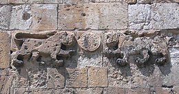
On the west and east faces of the bridge are two nearly identical inscriptions, flanked by two lions (or leopards). The inscription on the east reads as follows:
Bismallah..., and blessings on their lord Muhammad, his family and his companions. The building of this blessed bridge was ordered by their master, the great Sultan al-Malik al-Zahir Rukn al-Din Baybars, ibn Abd Allah, in time of his son their Lord Sultan al-Malik al-Said Nasir al-Din Baraka Khan, may Allah glorify their victories and grant them His grace. And that, under the direction of the humble servant aspiring to the mercy of Allah. Ala al-Din Ali al-Suwwaq, may Allah grant grace to him and his parents, in the month of Ramadan, the year 671 H. [March–April 1273 C.E.]
Ala al-Din Ali al-Suwwaq was the same official charged with overseeing the construction of the Great Mosque of Lydda three years earlier.[7]
During the 18th and 19th centuries, the bridged served a major road in the Nahiyeh (sub-district) of Lod that encompassed the area of the present-day city of Modi'in-Maccabim-Re'ut in the south to the present-day city of El'ad in the north, and from the foothills in the east, through the Lod Valley to the outskirts of Jaffa in the west. This area was home to thousands of inhabitants in about 20 villages, who had at their disposal tens of thousands of hectares of prime agricultural land.[8]
In 1882 the Palestine Exploration Fund's Survey of Western Palestine noted that Jisr Jindas had a representation of two lions and an Arabic text. It further noted that it appeared to be "Saracenic work".[9]
Description
[edit]The bridge is over 30 metres (98 ft) long and 10 metres (33 ft) wide, and runs north–south. It consists of three arches and two central piers, with the central arch wider than the two other arches.[2]
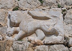
Baybars panthers or lions
[edit]In his native Turkic language, Baibars' name means "great panther".[10] Possibly based on that, Baibars used the panther as his heraldic blazon, and placed it on both coins and buildings.[10] On the Bridge of Jindas, the lions/panthers used play with a rat, which may be interpreted to represent Baibars' Crusader enemies.[11]
According to Moshe Sharon, the lions on Jisr Jindas are similar to the ones on the Lions' Gate in Jerusalem, and Qasr al-Basha in Gaza. All represent the same sultan: Baybars. The Gaza lions were created with interlocking lines suggesting leopard spots, however, the felines' outline is similar. Sharon estimates that they all date to approximately 1273 C.E.[12]
-
 Baibars' lion on the Bridge of Jindas
 -
 Baibars' lions on Lions' Gate, Jerusalem
 -
 Baibars' lion from Qal'at al-Subeiba, at the foot of Mount Hermon


See also
[edit]- List of Roman bridges
- Barid, Muslim postal network renewed during Mamluk period (roads, bridges, khans)
- Jisr al-Ghajar, stone bridge south of Ghajar
- Daughters of Jacob Bridge (Jisr Banat Yaqub)
- Al-Sinnabra Crusader bridge, with nearby Jisr Umm el-Qanatir/Jisr Semakh and Jisr es-Sidd further downstream
- Jisr al-Majami bridge over the Jordan, with Mamluk khan
- Yibna Bridge or "Nahr Rubin Bridge"
- Isdud Bridge (Mamluk, 13th century) outside Ashdod/Isdud
- Jisr ed-Damiye, bridges over the Jordan (Roman, Mamluk, modern)
References
[edit]- ^ "The bridge of Jindas", according to Palmer, 1881, p. 215
- ^ Jump up to: a b Petersen, 2001, p. 183
- ^ Marom, Roy (2022-11-01). "Jindās: A History of Lydda's Rural Hinterland in the 15th to the 20th Centuries CE". Lod, Lydda, Diospolis. 1: 4–6.
- ^ Petersen, 2008, p. 297
- ^ O’Connor, 1993
- ^ Jump up to: a b c Clermont-Ganneau, 1896, vol.2, pp.110–117
- ^ Petersen, 2001, p. 184
- ^ Marom, Roy (2022). "Lydda Sub-District: Lydda and its countryside during the Ottoman period". Diospolis - City of God: Journal of the History, Archaeology and Heritage of Lod. 8: 103–136.
- ^ Conder and Kitchener, 1882, SWP II, pp. 264–5
- ^ Jump up to: a b Heghnar Zeitlian Watenpaugh (2004). The image of an Ottoman city: imperial architecture and urban experience in Aleppo in the 16th and 17th centuries. Brill. p. 198. ISBN 90-04-12454-3.
- ^ Niall Christie (2014). Muslims and Crusaders: Christianity's Wars in the Middle East, 1095-1382, from the Islamic Sources. Seminar Studies (first ed.). Routledge. p. 121, Plate 8. ISBN 9781138022744.
- ^ Sharon, 2009, p. 58 and pl.6.
Bibliography
[edit]- Clermont-Ganneau, C.S., "Le pont de Beibars à Lydda." In Recueil d'archéologie orientale. Clermont-Ganneau, Charles. 262–279. Paris: Ernest Leroux, 1888. (editio princeps)
- Clermont-Ganneau, C.S. (1896). [ARP] Archaeological Researches in Palestine 1873–1874, translated from the French by J. McFarlane. Vol. 2. London: Palestine Exploration Fund.
- Conder, C.R.; Kitchener, H.H. (1882). The Survey of Western Palestine: Memoirs of the Topography, Orography, Hydrography, and Archaeology. Vol. 2. London: Committee of the Palestine Exploration Fund.
- Marom, R. (2021). Jindās at Lydda’s Entrance: A Cornerstone of the Study of the City’s Rural Hinterland (1459 – 1948). Diospolis 7, 9-43.
- Marom, R. (2022). Jindās: A History of Lydda's Rural Hinterland in the 15th to the 20th Centuries CE. Lod, Lydda, Diospolis 1, 1-31.
- O’Connor, Colin (1993), Roman Bridges, Cambridge University Press, ISBN 0-521-39326-4
- Palmer, E.H. (1881). The Survey of Western Palestine: Arabic and English Name Lists Collected During the Survey by Lieutenants Conder and Kitchener, R. E. Transliterated and Explained by E.H. Palmer. Committee of the Palestine Exploration Fund.
- Петерсен, Эндрю (2001). Газета зданий в мусульманской Палестине (Британская академическая монография в археологии) . Тол. 1. издательство Оксфордского университета . ISBN 978-0-19-727011-0 .
- Петерсен, А. (2008): Мосты в средневековой Палестине , в У. Вермелен и К. Дхульстер (ред.), » в эре Фатимид, Эйюбид и Мамлук История Египта и Сирии . « , V. Peeters, Leuven
- Шарон, М. (1999). Надписи тела в арабской Палестине, Британская Колумбия . Тол. 2. Брилл. ISBN 90-04-11083-6 Полем С.229 : «Из Рамла, маршрут продолжал добываться (Лидда) и через мост (недалеко от Джиндаса) к северу от города, построенного в 1273 году, до хана Джалджуля , построенного около 1325 года».
- Шарон, М. (2009). Надписи тела Палестина, Г. Тол. 4. Брилл. ISBN 978-90-04-17085-8 .
Внешние ссылки
[ редактировать ]- Обследование Западной Палестины, Карта 13: IAA , Wikimedia Commons
| Базы данных управления авторитетом : национальный |
|---|
31 ° 58′07,51 ″ N 34 ° 54′00,78 ″ E / 31,9687528 ° N 34,9002167 ° E