Хол, Норвегия

Хол муниципалитет
Хол муниципалитет | |
|---|---|
 | |
 Флаг  Герб | |
 Buskerud within Norway | |
 Hol within Buskerud | |
| Coordinates: 60°34′18″N 8°4′18″E / 60.57167°N 8.07167°E | |
| Country | Norway |
| County | Buskerud |
| District | Hallingdal |
| Administrative centre | Hol |
| Government | |
| • Mayor (2003) | Erik Kaupang (Ap) |
| Area | |
| • Total | 1,858 km2 (717 sq mi) |
| • Land | 1,664 km2 (642 sq mi) |
| • Rank | #36 in Norway |
| Population (2003) | |
| • Total | 4,556 |
| • Rank | #211 in Norway |
| • Density | 3/km2 (8/sq mi) |
| • Change (10 years) | |
| Demonym | Holing[1] |
| Official language | |
| • Norwegian form | Neutral |
| Time zone | UTC+01:00 (CET) |
| • Summer (DST) | UTC+02:00 (CEST) |
| ISO 3166 code | NO-3330[3] |
| Website | Official website |
HOL - это муниципалитет в Бускерад округе , Норвегия .
Административная история
[ редактировать ]Площадь HOL была отделена от муниципалитета в 1877 году, чтобы стать отдельным муниципалитетом. В 1937 году часть соседнего UVDAL с 220 жителями переехала в муниципалитет HOL. Площадь была перенесена из UVDAL в HOL в 1944 году. UVDAL был воссоединен с NORE, чтобы сформировать новый муниципалитет Nore OG UVDAL .
Общая информация
[ редактировать ]Имя
[ редактировать ]Муниципалитет (первоначально приход ) назван в честь старой фермы HOL ( старый скандинавский : Hóll ), так как первая церковь была построена здесь. Название идентично слову Холл , что означает «круглый (и изолированный) холм».
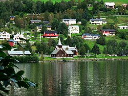
Деревни и деревня в муниципалитете Hol
[ редактировать ]Geography
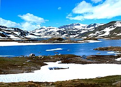
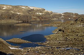
[edit]Hol is bordered to the north by Lærdal, to the north and east by Ål, to the south by Nore og Uvdal, and to the west by Eidfjord, Ulvik and Aurland. Hol is a mountainous area, where over 90% of the area is at an altitude exceeding 900 meters above sea level. The Hallingskarvet mountain range is the highest point in the municipality, at 1933 meters above sea level. The Usta or Usteåne River flows northeast from Lake Ustevatn traveling down the Ustedalen valley. The Hallingdalselva River is formed by the confluence of the Usta River and the Holselva River from Lake Strandavatnet.
Lakes
[edit]- Ustevatn – in the municipality of Hol
- Nygardsvatnet – in the municipality of Hol
- Strandavatnet – in the municipality of Hol
- Ørteren – in the municipality of Hol
- Nyhellervatnet – on the border between Hol and Aurland, Vestland county
- Pålsbufjorden – in the municipalities of Hol and Nore og Uvdal
- Øvre Hein – in the municipalities of Hol and Nore og Uvdal
- Djupsvatnet – in the municipalities of Hol and Ål
- Flakavatnet – in the municipalities of Hol and Ulvik, Hordaland county
Mountains
[edit]Coat-of-arms
[edit]The coat-of-arms of Hol is from modern times; the arms were granted on 5 July 1991. They show three silver anvils on a blue background and were designed by Trond Andersson. The three anvils are stacked one above the other, with the top one being largest and the bottom one smallest. The anvil was chosen to symbolize the former smithies in the municipality, which were famous for the production of axes, blades, and knives. Iron mining was already practiced in the area in the Viking Age.[4][5]
| Ancestry | Number |
|---|---|
| 177 | |
| 70 | |
| 65 | |
| 43 | |
| 37 |
(See also coat-of-arms of Trøgstad)

Hol Old Church
[edit]Hol Old Church (Hol gamle kirke) is presumed to date from the 13th century, but the exact dating is unknown. The church is the oldest parish in Hol and is first mentioned in a letter from 1328 as a small stave church with covered side porches (svalganger). The church has been expanded several times, in the 16th century, in 1697 and in 1798–99. It was rebuilt in 1888 and 1938. It is believed that the floor of the church was made using columns from the old stave church. The pulpit and baptismal font are from the Renaissance period (1697) and the altarpiece from 1703. The pulpit is placed above the altar.[7]
Notable residents
[edit]
- Knut Henriksen Dybsjord (1809–1866), mayor and temperance movement activist
- Pål Olson Grøt (1813–1906), Rosemåling painter
- Olav Sletto (1886–1963), novelist and educator
- Knut Bry (born 1946 in Hovet), fine-art photographer and film director[8]
- Terje Isungset (born 1964), musician, percussionist and composer
Sport
[edit]- Margit Hvammen (1932 in Geilo – 2010) alpine skier
- Aud Hvammen (born 1943 in Geilo), alpine skier
- Anne Brusletto (born 1951 in Geilo), alpine skier
- Martin Hole (born 1959), former cross country runner
- Ådne Søndrål (born 1971), former speed skater and gold medallist at the 1998 Winter Olympics
- Håvard Bøkko (born 1987 in Hovet), speed skater
- Roger S. Kleivdal (born 1988), snowboarder
- Christoffer Fagerli Rukke (born 1988), speed skater
- Hege Bøkko (born 1991 in Hovet), speed skater
- Vetle Sjåstad Christiansen (born 1992 in Geilo), biathlete
- Tiril Sjåstad Christiansen (born 1995 in Geilo), freestyle skier
Gallery
[edit]-
 Lake Geiteryggen
 -
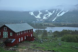
 Traditionally built farm in Hol
 -
 Lake Flakavatn
 -
 Geilo
Geilo -
 Geiteryggen
 -
![Skurdalen Church (Skurdalskyrkja)[9]](//upload.wikimedia.org/wikipedia/commons/thumb/8/8d/Skurdalen_kirke.jpg/254px-Skurdalen_kirke.jpg) Skurdalen Church (Skurdalskyrkja)[9]
Skurdalen Church (Skurdalskyrkja)[9] -
 Rossdøla River


![Skurdalen Church (Skurdalskyrkja)[9]](http://upload.wikimedia.org/wikipedia/commons/thumb/8/8d/Skurdalen_kirke.jpg/254px-Skurdalen_kirke.jpg)

Attractions
[edit]- Hallingskarvet National Park – national park in the municipalities of Hol (Buskerud), Ulvik (Hordaland) and Aurland (Sogn og Fjordane)
- Hol Bygdemuseum – located along the road from Ål to Geilo in the small village of Hagafoss. The museum is built as an old farm (holingsgard) with buildings of the local type. There are a total of 17 buildings, of which two, Nestegardsstugu and Raunsgardsstugu, have decorative wall paintings on the walls.
- Dagali Museum – museum with ten buildings located in the middle of Dagali, on the edge of Hardangervidda. The buildings came from Dagali, Skurdalen, Tunhovd, and Uvdal; the oldest dates to the 18th century.
- Dagali Skisenter – alpine resort in Dagali, also offering sled-racing, with one of Norway's longest sled-racing hills.
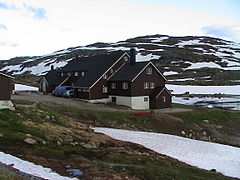
- Dr Holms Hotel – resort hotel in the ski resort town of Geilo
Sister cities
[edit]The following cities are twinned with Hol:[10]
 – Halinga Parish, Pärnu County, Estonia
 – Mäntyharju, South Savo, Finland
 – Säffle, Värmland County, Sweden
See also
[edit]External links
[edit]- Municipal fact sheet from Statistics Norway
 Buskerud travel guide from Wikivoyage
- Dagali Opplevelser – offering a great deal of activities in and around Dagali (in Norwegian)
- Dagali Skisenter Archived 2019-04-18 at the Wayback Machine – The alpine resort in Dagali (in Norwegian)
- Map hiking and DNT cabins
References
[edit]- ^ "Navn på steder og personer: Innbyggjarnamn" (in Norwegian). Språkrådet.
- ^ "Forskrift om målvedtak i kommunar og fylkeskommunar" (in Norwegian). Lovdata.no.
- ^ Bolstad, Erik; Thorsnæs, Geir, eds. (2023-01-26). "Kommunenummer". Store norske leksikon (in Norwegian). Kunnskapsforlaget.
- ^ Norske Kommunevåpen (1990). "Nye kommunevåbener i Norden". Retrieved 2009-01-07.
- ^ "Kommunevåpenet" (на норвежском языке). Hol Kommune. Архивировано из оригинала 2010-08-16 . Получено 2009-01-07 .
- ^ «Иммигранты и норвежские родители иммигрантов, по категории иммиграции, страновому происхождению и проценту населения» . SSB.NO Архивировано с оригинала 2 июля 2015 года . Получено 29 июля 2017 года .
- ^ Сигрид Мари Кристи, Хокон Кристи. "Хол Старая Церковь" . Церкви Норвегии . Получено 15 сентября 2016 года .
- ^ База данных IMDB Получена 15 августа 2020 года
- ^ "Скурдальная церковь" . Норвежская церковь . Получено 1 декабря 2017 года .
- ^ «Муниципалитеты дружбы» (на норвежском языке). Хол муниципалитет. Архивировано из оригинала (Microsoft Word) 2011-07-24 . Получено 2009-01-07 .
| |||||||||
 | Города и поселки | ||||||||
| Муниципалитеты |
| ||||||||