Тинглой

Эта статья требует дополнительных цитат для проверки . ( октябрь 2012 г. ) |
Тинглой | |
|---|---|
| Муниципалитет Тинглой | |
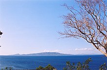
 Рыбацкая деревня в Тинглой | |
 Seal | |
 Map of Batangas with Tingloy highlighted | |
OpenStreetMap | |
 Tingloy Location within the Philippines | |
| Coordinates: 13°39′N 120°52′E / 13.65°N 120.87°E | |
| Country | Philippines |
| Region | Calabarzon |
| Province | Batangas |
| District | 2nd district |
| Founded | June 17, 1955[1] |
| Barangays | 15 (see Barangays) |
| Government | |
| • Type | Sangguniang Bayan |
| • Mayor | Lauro F. Alvarez |
| • Vice Mayor | Dawn Erika E. Alvarez |
| • Representative | Gerville Luistro |
| • Municipal Council | Members |
| • Electorate | 11,622 voters (2022) |
| Area | |
| • Total | 33.07 km2 (12.77 sq mi) |
| Elevation | 16 m (52 ft) |
| Highest elevation | 487 m (1,598 ft) |
| Lowest elevation | 0 m (0 ft) |
| Population (2020 census)[4] | |
| • Total | 19,215 |
| • Density | 580/km2 (1,500/sq mi) |
| • Households | 5,103 |
| Economy | |
| • Income class | 5th municipal income class |
| • Poverty incidence | 9.35 |
| • Revenue | ₱ 77.57 million (2020) |
| • Assets | ₱ 142 million (2020) |
| • Expenditure | ₱ 64.8 million (2020) |
| • Liabilities | ₱ 32.96 million (2020) |
| Service provider | |
| • Electricity | Batangas 2 Electric Cooperative (BATELEC 2) |
| Time zone | UTC+8 (PST) |
| ZIP code | 4203 |
| PSGC | |
| IDD : area code | +63 (0)43 |
| Native languages | Tagalog |

Тинглой , официально Тинглой ( Тагаль : Баян Нг Тинлой ), является муниципалитетом класса в провинции Батангас Филиппины , 5 -го муниципалитет Согласно переписи 2020 года, население составляет 19 215 человек, что делает его наименее населенным муниципалитетом в провинции. [ 4 ]
Муниципалитет включает в себя остров Марикабан, остров Кабан и другие второстепенные островки, все к югу от полуострова Калумпанг . Посетители его пляжей и средств для дайвинга являются источником дохода.
История
[ редактировать ]The name "Tingloy" was, according to legend, derived from a plant of almost the same name, "tinghoy", which is largely found in abundance on the island up to now.[citation needed]
The first people to inhabit the island almost a century ago[when?] came from Taal and Bauan, presumably to escape the brutalities perpetrated by the Spanish "conquistadors". They came in family groups and finding the place a haven, settled down in definite areas later forming the various barrios now comprising the created political subdivision. It is said that the former barrio of Tingloy was founded by Jose Martinez, a Taaleño.[6][verification needed]
At several times the island was placed under the jurisdiction of different towns. The island was originally part of the town of San Luis. In 1917, it was placed under the jurisdiction of Bauan, only to be separated from it a year later when the municipality of Mabini was formed. In 1921, it was again placed under the jurisdiction of Bauan.
During the Spanish regime, people were educated at home learning to read the "Cartillas" and the "Caton" "Christiana". During American occupation schools were established. Ireneo Martinez together with Flaviano Gamben, initiated a movement for a model schoolhouse for the former barrio of Tingloy. This movement became a success when a model schoolhouse was constructed in the present poblacion of the Municipality of Tingloy sometime in 1921.[6]
During the second regular session of the 3rd Congress of the Philippines, the barrios of Tingloy, Maricaban, Papaya, Pisa, Gamao, and Talahib were separated from Bauan and constituted into the newly created municipality of Tingloy.[7] President Ramon Magsaysay, on June 17, 1955, appointed the first municipal officials headed by Ramon De Claro as mayor.
Geography
[edit]According to the Philippine Statistics Authority, the municipality has a land area of 33.07 square kilometres (12.77 sq mi) [8] constituting 1.06% of the 3,119.75-square-kilometre- (1,204.54 sq mi) total area of Batangas.
Just off the southwest coast of the Batangas mainland, about two nautical miles (3.7 kilometres) south, lies the radish-shaped island of Maricaban. It has a land area of about 14 square miles (36 square kilometres) of rugged hills and sloping mountains with occasional lowland plains and valleys.
Barangays
[edit]Tingloy is politically subdivided into 15 barangays.[9] Each barangay consists of puroks and some have sitios.
| PSGC | Barangay | Population | ±% p.a. | |||
|---|---|---|---|---|---|---|
| 2020[4] | 2010[10] | |||||
| 041033001 | Corona | 4.5% | 861 | 870 | −0.10% | |
| 041033003 | Gamao | 5.5% | 1,062 | 1,039 | 0.22% | |
| 041033004 | Makawayan | 5.1% | 977 | 982 | −0.05% | |
| 041033005 | Marikaban | 6.4% | 1,221 | 1,112 | 0.94% | |
| 041033006 | Papaya | 9.1% | 1,747 | 1,732 | 0.09% | |
| 041033007 | Pisa | 6.1% | 1,181 | 965 | 2.04% | |
| 041033008 | Barangay 13 (Poblacion 1) | 4.6% | 876 | 794 | 0.99% | |
| 041033009 | Barangay 14 (Poblacion 2) | 4.6% | 886 | 812 | 0.88% | |
| 041033010 | Barangay 15 (Poblacion 3) | 4.5% | 867 | 722 | 1.85% | |
| 041033011 | San Isidro | 8.8% | 1,686 | 1,459 | 1.46% | |
| 041033012 | San Jose | 7.4% | 1,428 | 1,197 | 1.78% | |
| 041033013 | San Juan | 10.0% | 1,916 | 1,821 | 0.51% | |
| 041033014 | San Pedro | 2.5% | 477 | 527 | −0.99% | |
| 041033015 | Santo Tomas | 8.7% | 1,673 | 1,677 | −0.02% | |
| 041033016 | Talahib | 5.5% | 1,061 | 1,161 | −0.90% | |
| Total | 19,215 | 16,870 | 1.31% | |||
Climate
[edit]| Climate data for Tingloy, Batangas | |||||||||||||
|---|---|---|---|---|---|---|---|---|---|---|---|---|---|
| Month | Jan | Feb | Mar | Apr | May | Jun | Jul | Aug | Sep | Oct | Nov | Dec | Year |
| Mean daily maximum °C (°F) | 28 (82) |
29 (84) |
30 (86) |
31 (88) |
31 (88) |
30 (86) |
29 (84) |
29 (84) |
29 (84) |
29 (84) |
29 (84) |
28 (82) |
29 (85) |
| Mean daily minimum °C (°F) | 22 (72) |
21 (70) |
22 (72) |
23 (73) |
25 (77) |
25 (77) |
25 (77) |
25 (77) |
25 (77) |
24 (75) |
23 (73) |
22 (72) |
24 (74) |
| Average precipitation mm (inches) | 48 (1.9) |
32 (1.3) |
41 (1.6) |
54 (2.1) |
257 (10.1) |
410 (16.1) |
466 (18.3) |
422 (16.6) |
429 (16.9) |
300 (11.8) |
137 (5.4) |
92 (3.6) |
2,688 (105.7) |
| Average rainy days | 10.8 | 8.0 | 9.8 | 11.7 | 23.1 | 27.5 | 29.2 | 28.7 | 28.7 | 25.5 | 18.2 | 12.8 | 234 |
| Source: Meteoblue[11] | |||||||||||||
Demographics
[edit]| Year | Pop. | ±% p.a. |
|---|---|---|
| 1960 | 7,656 | — |
| 1970 | 10,636 | +3.34% |
| 1975 | 11,963 | +2.39% |
| 1980 | 13,381 | +2.26% |
| 1990 | 15,430 | +1.44% |
| 1995 | 14,897 | −0.66% |
| 2000 | 17,028 | +2.91% |
| 2007 | 18,548 | +1.19% |
| 2010 | 16,870 | −3.39% |
| 2015 | 17,919 | +1.16% |
| 2020 | 19,215 | +1.38% |
| Source: Philippine Statistics Authority[12][10][13][14] | ||
In the 2020 census, Tingloy had a population of 19,215.[4] The population density was 580 inhabitants per square kilometre (1,500/sq mi).
Economy
[edit]Poverty incidence of Tingloy
10
20
30
40
50
2006
44.00 2009
26.19 2012
31.64 2015
26.22 2018
19.08 2021
9.35 Source: Philippine Statistics Authority[15][16][17][18][19][20][21][22] |
Attractions
[edit]
- Masasa Beach (Barangay San Juan) is one of the most visited beaches of the place, and is known for its white sand and beautiful sunset. It is located on the other side of the island which is accessible by walking or tricycle.
- Mag-Asawang Bato is one of the two peaks of the island, and this is the most visited peak by mountaineers and nature enthusiasts, where a 360° view of the whole island can be seen.
- Isla Sombrero (Sombrero Island) is a small uninhabited island located at the eastern tip of Maricaban. It is accessible through a medium-sized motor-boat or banka, and is one of the most visited beach attractions in the island.
- Batalang-Bato (Pulang Buli) is a fish sanctuary between Barangay Santo Tomas and Barangay Talahib. For research diving and snorkeling, permission is needed from the BBMC and the barangay councils of Santo Tomas and Talahib.
- Caban Island is also considered one of the tourist spots because of its white sand and scattered beaches surrounding the island.One of these are Mapating Beach, Layag Layag Point, Caban Island Beach, Fortales Beach and Bahay Kambing.
- Diving is one of the major activities in the town because of its different diving spots.
References
[edit]- ^ "Republic Act No. 1344 : REPUBLIC ACTS - PHILIPPINE LAWS STATUTES and CODES - CHANROBLES VIRTUAL LAW LIBRARY".
- ^ Municipality of Tingloy | (DILG)
- ^ "2015 Census of Population, Report No. 3 – Population, Land Area, and Population Density" (PDF). Philippine Statistics Authority. Quezon City, Philippines. August 2016. ISSN 0117-1453. Archived (PDF) from the original on May 25, 2021. Retrieved July 16, 2021.
- ^ Jump up to: a b c d Census of Population (2020). "Region IV-A (Calabarzon)". Total Population by Province, City, Municipality and Barangay. Philippine Statistics Authority. Retrieved 8 July 2021.
- ^ "PSA Releases the 2021 City and Municipal Level Poverty Estimates". Philippine Statistics Authority. 2 April 2024. Retrieved 28 April 2024.
- ^ Jump up to: a b "TINGLOY TOWN", TINGLOY TOWN FIESTA SOUVENIR PROGRAM, 1979-10-18
- ^ "Republic Act No. 1344 - An Act to Create the Municipality of Tingloy in the Province of Batangas". Chan Robles Virtual Law Library. 17 June 1955. Retrieved 11 December 2016.
- ^ "Province: Batangas". PSGC Interactive. Quezon City, Philippines: Philippine Statistics Authority. Retrieved 12 November 2016.
- ^ "Муниципальный: Тинглой" . PSGC Interactive . Кесон -Сити, Филиппины: Филиппинская статистическая Управление . Получено 8 января 2016 года .
- ^ Jump up to: а беременный Перепись населения и жилья (2010). «Регион IV-A (Калабарзон)» (PDF) . Общая численность населения по провинции, городу, муниципалитету и барангай . Национальное статистическое управление . Получено 29 июня 2016 года .
- ^ "Тинглой: средний и осадки Meeblus Получено 5 мая
- ^ Перепись населения (2015). «Регион IV-A (Калабарзон)» . Общая численность населения по провинции, городу, муниципалитету и барангай . Филиппинская статистическая власть . Получено 20 июня 2016 года .
- ^ Перепись населения (1903–2007). «Регион IV-A (Калабарзон)» . Таблица 1. Население перечислено в различных переписи провинции/высоко урбанизированным городом: с 1903 по 2007 год . Национальное статистическое управление .
- ^ «Провинция Батангас» . Данные муниципалитета населения . местных водоснабжений Отдел исследований исследований . Получено 17 декабря 2016 года .
- ^ «Заболеваемость бедности (PI):» . Филиппинская статистическая власть . Получено 28 декабря 2020 года .
- ^ «Оценка местной бедности на Филиппинах» (PDF) . Филиппинская статистическая власть. 29 ноября 2005 г.
- ^ «Оценка бедности города 2003 года» (PDF) . Филиппинская статистическая власть. 23 марта 2009 г.
- ^ «Оценки бедности города и муниципального уровня; 2006 и 2009 гг.» (PDF) . Филиппинская статистическая власть. 3 августа 2012 года.
- ^ «2012 Муниципальные и городские оценки бедности» (PDF) . Филиппинская статистическая власть. 31 мая 2016 года.
- ^ «Муниципальный и городской уровень малой площади; 2009, 2012 и 2015 годы» . Филиппинская статистическая власть. 10 июля 2019 года.
- ^ «PSA выпускает оценки муниципального и городского уровня в 2018 году» . Филиппинская статистическая власть. 15 декабря 2021 года . Получено 22 января 2022 года .
- ^ «PSA выпускает оценки бедности города и муниципального уровня в 2021 году» . Филиппинская статистическая власть. 2 апреля 2024 года . Получено 28 апреля 2024 года .
Внешние ссылки
[ редактировать ]Места рядом с Тинглой |
|---|
| Компонентные города | |
|---|---|
| Муниципалитеты | |