National Register of Historic Places listings in Hampton, Virginia

This is a list of the National Register of Historic Places listings in Hampton, Virginia.
This is intended to be a complete list of the properties and districts on the National Register of Historic Places in the independent city of Hampton, Virginia, United States. The locations of National Register properties and districts for which the latitude and longitude coordinates are included below, may be seen in an online map.[1]
There are 30 properties and districts listed on the National Register in the city, including 5 National Historic Landmarks. Another 2 properties were once listed but have been removed.
This National Park Service list is complete through NPS recent listings posted July 26, 2024.[2]
Current listings
[edit]| [3] | Name on the Register[4] | Image | Date listed[5] | Location | Description |
|---|---|---|---|---|---|
| 1 | Aberdeen Gardens |  | May 26, 1994 (#94000456) | Roughly bounded by Langston and Mary Peake Boulevards and Russell, Davis, Lewis, Weaver, and Walker Rds. 37°02′00″N 76°24′21″W / 37.033333°N 76.405833°W | |
| 2 | Buckroe Beach Carousel |  | October 27, 1992 (#92001396) | 602 Settlers Landing Rd. 37°01′26″N 76°20′36″W / 37.023889°N 76.343333°W | |
| 3 | Chamberlin Hotel |  | March 21, 2007 (#07000190) | 2 Fenwick Rd., Fort Monroe 37°00′04″N 76°18′44″W / 37.001111°N 76.312222°W | |
| 4 | Chapel of the Centurion |  | March 28, 2011 (#10000582) | 134 Bernard Rd., Fort Monroe 37°00′10″N 76°18′28″W / 37.002639°N 76.307778°W | Oldest continually used wooden military structure for religious services in the United States; built in 1858[6] |
| 5 | Chesterville Plantation Site |  | August 14, 1973 (#73002211) | East of State Route 172[7] 37°06′12″N 76°23′18″W / 37.103333°N 76.388333°W | On the grounds of NASA Langley Research Center; boundary decrease approved October 26, 2022. |
| 6 | Reuben Clark House |  | August 16, 1984 (#84003542) | 125 S. Willard Ave. 37°00′52″N 76°19′11″W / 37.014444°N 76.319722°W | |
| 7 | Fort Monroe |  | October 15, 1966 (#66000912) | Old Point Comfort 37°00′18″N 76°18′27″W / 37.005000°N 76.307500°W | |
| 8 | Fort Wool |  | November 25, 1969 (#69000339) | Island between Willoughby Spit and Old Point Comfort 36°59′12″N 76°18′04″W / 36.986667°N 76.301111°W | |
| 9 | Hampton City Hall |  | August 8, 2007 (#07000806) | 100 Kings Way 37°01′35″N 76°20′39″W / 37.026389°N 76.344167°W | |
| 10 | Hampton Downtown Historic District | 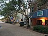 | December 27, 2010 (#10001062) | Roughly bounded by Franklin St., Lincoln St., Settlers Landing Rd., and Eaton St. 37°01′34″N 76°20′40″W / 37.026111°N 76.344444°W | |
| 11 | Hampton Institute |  | November 12, 1969 (#69000323) | Northwest of the junction of U.S. Route 60 and the Hampton Roads Bridge-Tunnel 37°01′14″N 76°20′25″W / 37.020556°N 76.340278°W | |
| 12 | Hampton National Cemetery | 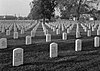 | February 26, 1996 (#96000038) | Junction of Cemetery Rd. and Marshall Ave. 37°01′11″N 76°20′06″W / 37.019722°N 76.335000°W | |
| 13 | Hampton National Guard Armory |  | November 22, 2016 (#16000798) | 504 N. King St. 37°01′53″N 76°20′43″W / 37.031389°N 76.345278°W | |
| 14 | Herbert House |  | February 23, 1972 (#72001504) | East end of Marina Rd. on Hampton Creek 37°00′59″N 76°20′35″W / 37.016250°N 76.343056°W | |
| 15 | Little England Chapel |  | July 8, 1982 (#82004564) | 4100 Kecoughtan Rd. 37°00′47″N 76°21′10″W / 37.013194°N 76.352639°W | |
| 16 | Lunar Landing Research Facility |  | October 3, 1985 (#85002808) | Langley Research Center 37°06′06″N 76°23′23″W / 37.101667°N 76.389722°W | |
| 17 | NASA Langley Research Center (LaRC) Historic District |  | June 27, 2012 (#12000374) | Roughly bounded by Wythe Creek Rd., Commander Shepard Blvd., Brick Kiln Cr., & Langley Air Force Base 37°05′01″N 76°20′31″W / 37.083611°N 76.341944°W | |
| 18 | Old Point Comfort Lighthouse |  | March 1, 1973 (#73002212) | Fenwick Rd., southwest of the east gate of Fort Monroe 37°00′07″N 76°18′23″W / 37.001806°N 76.306500°W | |
| 19 | Old Wythe Historic District |  | October 31, 2012 (#12000905) | Roughly bounded by Hanover St., Pear Ave., Hampton Ave., and Kecoughtan Rd. 36°59′42″N 76°23′24″W / 36.995000°N 76.390000°W | |
| 20 | Pasture Point Historic District |  | October 22, 2012 (#08000940) | Bounded by the Hampton River on the east, Bright's Creek on the north, Wine St. on the west, and Syms St. on the south 37°01′52″N 76°20′29″W / 37.031111°N 76.341389°W | |
| 21 | Phoebus Historic District | 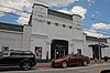 | December 1, 2006 (#06001098) | Roughly bounded by Interstate 64, Mallory St., E. County St., and Willard Ave. 37°00′59″N 76°19′23″W / 37.016389°N 76.323056°W | |
| 22 | Quarters 1 |  | March 28, 2011 (#10000583) | 151 Bernard Rd., Fort Monroe 37°00′14″N 76°18′20″W / 37.003889°N 76.305556°W | Headquarters of Fort Monroe from 1819 to 1907;[8] quarters used by Abraham Lincoln while planning the attack on Norfolk during the American Civil War[9] |
| 23 | Quarters 17 |  | March 28, 2011 (#10000584) | 41A, 41B, 47A, 47B Bernard Rd., Fort Monroe 37°00′09″N 76°18′32″W / 37.0025°N 76.308889°W | Quarters of Robert E. Lee during the construction of Fort Monroe, 1831–1834;[10] |
| 24 | Rendezvous Docking Simulator |  | October 3, 1985 (#85002809) | Langley Research Center 37°05′08″N 76°22′38″W / 37.085556°N 76.377222°W | |
| 25 | St. John's Church |  | February 26, 1970 (#70000871) | Northwest corner of W. Queen and Court Sts. 37°01′34″N 76°20′48″W / 37.026111°N 76.346667°W | The oldest English-speaking church in the US, est. 1610.[11] |
| 26 | Scott House |  | August 5, 1999 (#99000967) | 232 S. Armistead Ave. 37°01′22″N 76°21′01″W / 37.022778°N 76.350278°W | |
| 27 | Thimble Shoal Light Station | 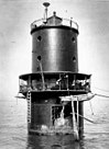 | December 2, 2002 (#02001436) | Approximately 1.5 miles (2.4 km) east of Fort Monroe Military Reservation 37°01′02″N 76°14′24″W / 37.017222°N 76.240000°W | |
| 28 | William H. Trusty House |  | June 22, 1979 (#79003280) | 76 W. County St. 37°01′19″N 76°19′28″W / 37.021806°N 76.324444°W | |
| 29 | Variable Density Tunnel |  | October 3, 1985 (#85002795) | Langley Research Center 37°04′43″N 76°20′39″W / 37.078611°N 76.344167°W | |
| 30 | Victoria Boulevard Historic District |  | October 4, 1984 (#84000039) | Roughly bounded by Sunset Creek, Armisted and Linden Aves., and Bridge St. 37°01′09″N 76°20′53″W / 37.019167°N 76.348056°W |

Former listings
[edit]| [3] | Name on the Register | Image | Date listed | Date removed | Location | City or town | Description |
|---|---|---|---|---|---|---|---|
| 1 | Eight-Foot High Speed Tunnel |  | October 3, 1985 (#85002798) | August 25, 2014 | Langley Research Center 37°04′56″N 76°20′29″W / 37.082222°N 76.341389°W | Hampton | |
| 2 | Full Scale Tunnel |  | October 3, 1985 (#85002796) | August 25, 2014 | Langley Research Center 37°04′58″N 76°20′30″W / 37.082778°N 76.341667°W | Hampton |
See also
[edit]Wikimedia Commons has media related to National Register of Historic Places in Hampton, Virginia.
- List of National Historic Landmarks in Virginia
- National Register of Historic Places listings in Virginia
References
[edit]- ^ The latitude and longitude information provided in this table was derived originally from the National Register Information System, which has been found to be fairly accurate for about 99% of listings. Some locations in this table may have been corrected to current GPS standards.
- ^ National Park Service, United States Department of the Interior, "National Register of Historic Places: Weekly List Actions", retrieved July 26, 2024.
- ^ Jump up to: а б Числа представляют собой алфавитный порядок значимых слов. Различные цвета, определенные здесь , отличают национальные исторические достопримечательности и исторические районы от других зданий, построек, мест или объектов NRHP.
- ^ «Национальная регистрационная информационная система» . Национальный реестр исторических мест . Служба национальных парков . 24 апреля 2008 г.
- ^ Восьмизначный номер под каждой датой — это номер, присвоенный каждому месту в базе данных информационной системы Национального реестра , который можно просмотреть, щелкнув номер.
- ^ Stefansky, Krys (March 22, 2009). "Army post at peace". The Virginian-Pilot. Hampton Roads, Virginia: Landmark Media Enterprises. Retrieved April 14, 2011.
- ^ Calloway, Graham. Structure Locations at Chesterville, NASA, 2010. Accessed 2013-03-16.
- ^ "Fort Monroe History". City of Hampton, Virginia. Retrieved April 14, 2011.
- ^ Маколей, Дэвид (7 декабря 2009 г.). «Форт Монро в Хэмптон -Эйде для частного сектора» . Вирджинский пилот . Хэмптон Роудс, Вирджиния : Landmark Media Enterprises . Проверено 14 апреля 2011 г.
- ^ «Стандарты проектирования сохранения исторического наследия Форт-Монро» (PDF) . Форт Монро, Вирджиния: Управление Форта Монро. 18 июня 2010 г. с. 2C.19. Архивировано из оригинала (PDF) 22 марта 2012 года . Проверено 14 апреля 2011 г.
- ^ «Краткая история епископальной церкви Св. Иоанна» . Хэмптон, Вирджиния . Проверено 16 июня 2009 г.
