Meløy

Meløy Municipality
Meløy kommune | |
|---|---|
| Melø herred (historic name) | |
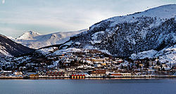 View of Ørnes in winter | |
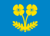 Flag | |
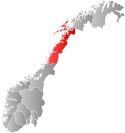 Nordland within Norway | |
 Meløy within Nordland | |
| Coordinates: 66°47′17″N 13°40′33″E / 66.78806°N 13.67583°E | |
| Country | Norway |
| County | Nordland |
| District | Salten |
| Established | 1 Jan 1884 |
| • Preceded by | Rødøy Municipality |
| Administrative centre | Ørnes |
| Government | |
| • Mayor (2015) | Sigurd Stormo (Ap) |
| Area | |
| • Total | 873.84 km2 (337.39 sq mi) |
| • Land | 798.08 km2 (308.14 sq mi) |
| • Water | 75.75 km2 (29.25 sq mi) 8.7% |
| • Rank | #133 in Norway |
| Population (2023) | |
| • Total | 6,212 |
| • Rank | #153 in Norway |
| • Density | 7.8/km2 (20/sq mi) |
| • Change (10 years) | |
| Demonym | Meløyfjerding[1] |
| Official language | |
| • Norwegian form | Bokmål |
| Time zone | UTC+01:00 (CET) |
| • Summer (DST) | UTC+02:00 (CEST) |
| ISO 3166 code | NO-1837[3] |
| Website | Official website |

Meløy is a municipality in Nordland county, Norway. It is part of the Salten traditional region. The administrative centre of the municipality is the village of Ørnes. Other villages include Eidbukta, Neverdal, Glomfjord, Halsa, Reipå, Støtt, and Ågskardet.
The municipality is situated just to the north of the Arctic Circle on Norway's west coast. It encompasses the island of Meløya and some 700 other islands of various sizes around the Meløyfjorden, Glomfjorden, and Holandsfjorden in the south, along with a stretch of mainland coast.
The 874-square-kilometre (337 sq mi) municipality is the 133rd largest by area out of the 356 municipalities in Norway. Meløy is the 153rd most populous municipality in Norway with a population of 6,212. The municipality's population density is 7.8 inhabitants per square kilometre (20/sq mi) and its population has decreased by 5.6% over the previous 10-year period.[4][5]
General information
[edit]

The municipality of Meløy was established on 1 January 1884 when the large Rødøy Municipality was separated into Rødøy (population: 1,945) in the south and Meløy (population: 2,696) in the north. The municipal borders have not changed since then.[6]
Name
[edit]The municipality (originally the parish) is named after the island of Meløya (Old Norse: Mjǫlva) since the first Meløy Church was built there. The first element comes from the word mjǫl which means "flour" or "meal" (referring to fine sand on the beaches of the island). The last element (which was added to the name around the year 1500) is øy which means "island".[7] Historically, the name of the municiaplity was spelled Melø. On 6 January 1908, a royal resolution changed the spelling of the name of the municipality to Meløy.[8]
Coat of arms
[edit]The coat of arms was granted on 7 December 1984. The official blazon is "Azure, a poppy plant Or" (Norwegian: I blått en gull valmueplante). This means the arms have a blue field (background) and the charge is a subspecies of the arctic poppy plant locally known as Svartisvalmue (Papaver radicatum subglobosum). The poppy plant has a tincture of Or which means it is commonly colored yellow, but if it is made out of metal, then gold is used. The municipality is located near the second largest glacier in continental Norway, the Svartisen (black ice), and the plant is one of the plants found growing closest to the ice. The colors symbolize the blue glacial ice and the yellow flowers. The arms were designed by Rolf Tidemann after the original ideda by Knut Sørensen.[9][10][11]
Churches
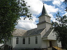
[edit]The Church of Norway has three parishes (sokn) within the municipality of Meløy. It is part of the Bodø domprosti (arch-deanery) in the Diocese of Sør-Hålogaland.
| Parish (sokn) | Church name | Location of the church | Year built |
|---|---|---|---|
| Fore og Meløy | Fore Church | Reipå | 1909 |
| Meløy Church | Meløya | 1867 | |
| Ørnes Church | Ørnes | 1990 | |
| Glomfjord | Glomfjord Church | Glomfjord | 1957 |
| Halsa | Halsa Church | Halsa | 1960 |
History
[edit]
Meløy has been inhabited for many centuries and still possesses various relics from the Viking Age. The Benkestok family, one of Norway's original noble families, established one of its seats at Meløy gård (farm) on the island of Meløya in the 16th century.
Due to the expansion of the community during the 19th century, it was split from its southern neighbour Rødøy in 1884. Its administrative centre was originally on Meløya, but it was later moved to the mainland coastal village of Ørnes. Ørnes is one of the stops on the route of the Hurtigruten (coastal express boat), with a notably scenic entrance via the fjord.
The second largest glacier in Norway, Svartisen, is a target for passenger visits. The mountains around Glomfjord are popular for fishing and hunting as well as skiing in the winter time.
Government
[edit]All municipalities in Norway are responsible for primary education (through 10th grade), outpatient health services, senior citizen services, welfare and other social services, zoning, economic development, and municipal roads and utilities. The municipality is governed by a municipal council of directly elected representatives. The mayor is indirectly elected by a vote of the municipal council.[12] The municipality is under the jurisdiction of the Salten og Lofoten District Court and the Hålogaland Court of Appeal.
Municipal council
[edit]The municipal council (Kommunestyre) of Meløy is made up of 23 representatives that are elected to four year terms. The tables below show the current and historical composition of the council by political party.
| Party name (in Norwegian) | Number of representatives | |
|---|---|---|
| Labour Party (Arbeiderpartiet) | 4 | |
| Progress Party (Fremskrittspartiet) | 5 | |
| Conservative Party (Høyre) | 3 | |
| Christian Democratic Party (Kristelig Folkeparti) | 1 | |
| Centre Party (Senterpartiet) | 4 | |
| Socialist Left Party (Sosialistisk Venstreparti) | 2 | |
| Liberal Party (Venstre) | 2 | |
| Meløy Free Voters (Meløy Frie Folkevalgte) | 2 | |
| Total number of members: | 23 | |
Mayors
[edit]The mayors (Norwegian: ordfører) of Meløy (incomplete list):
Geography
[edit]
The municipality of Meløy is a coastal community that includes many of the surrounding islands. Many parts of the mainland were fairly isolated until road tunnels were built during the 20th century that connected them to the rest of Norway. Some of the main islands of Meløy are Åmøya, Meløya, Bolga, Mesøya, Grønøya, and Støttvær. Åmøya is connected to the mainland via the Brattsund Bridge. The other islands are all accessible by boat or ferry only. The Kalsholmen Lighthouse is located in the southwestern part of the municipality.
The Vestfjorden passes Meløy in the northwest, and the Meløyfjorden, Glomfjorden, and Holandsfjorden cut into the mainland from the west. The Saltfjellet–Svartisen National Park is located in the southeast in the Saltfjellet mountain range, surrounding the Svartisen glacier.
Economy
[edit]The industrial development—and thus the main contributor to the economic development and growth of the Meløy community—started around the time of World War I. It was based on electrical power production in then new Glomfjord power plant from water coming from the Svartisen glacier and the lake Storglomvatnet and gathered in the mountains. In the bottom of Glomfjorden, Norsk Hydro (today YARA) started out producing fertilizers in Glomfjord, today yara is Meløy's biggest workplace with 190 people working there
A conglomerate of industries is found there today in Glomfjord Industry Park. The municipality's overall industries are some light industry, agriculture, forestry, fishing, salmon production, and tourism.
Meløy Energi, an electrical power company, is one of the most important employers in the municipality (as of Q4 2022).[32]
Notable people
[edit]- Eindride Sommerseth (1918 – 2010), Norwegian trade unionist and politician
- Arne Pettersen (1906 - 1981), Norwegian sailor, last person to leave Ellis Island.
Farms of Meløy
[edit]Map of the farms of Meløy
[edit]Coordinates are approximate.
Note that each map has a maximum number of listings it can display, so the map has been divided into parts consistent with the enumeration districts (tellingskrets) in the 1920 census. This map will include one farm name per farm number; other farm names or subdivision numbers may exist.

Tellingskrets (enumeration districts): 1, Bolga (lime); 2, Åmnes (black); 3, Herstad (blue); 4, Aag (purple); 5, Holand (green); 6, Sneland (red); 7, Halsa; (teal) 8, Bjerangen (gray).

2.5miles
Tellingskrets (enumeration districts): 9, Enga (lime); 10, Vasdal (teal); 11, Glomfjorden (blue); 12, Øbugt (purple); 13, Spildra (green); 14, Nordbygden (red); 15, Stol (black); 16, Meløy (gray).
Farm names and numbers
[edit]Following are the farms in the Meløy municipality, as they are listed in O. Rygh's series Norske_Gaardnavne ("Norwegian farm names"), the Nordland volume of which was published in 1905. Here is the digital version of that volume: <Norske_gaardnavne_bd_Nordlands>
The farm numbers are used in some census records, and numbers that are near each other indicate that those farms are geographically proximate. Handwritten Norwegian sources, particularly those prior to 1800, may use variants on these names. For recorded variants before 1723, see the digital version of O. Rygh. Note that the 1920 census records mapped above may not match O. Rygh.
Farm names were often used as part of Norwegian names, in addition to the person's given name and patronymic or inherited surname. Some families retained the farm name, or toponymic, as a surname when they emigrated, so in those cases tracing a surname may tell you specifically where in Norway the family was from. This tradition began to change in the mid to late 19th century, and inherited surnames were codified into law in 1923.
| Farm Name | Farm Number |
| Sneen | 1 |
| Bolgen | 2 |
| Harfjeld | 3 |
| Harfjeldstrand | 4 |
| Kjørhaugvik | 5 |
| Kjørhaug | 6 |
| Aamnes | 7 |
| Stavnes | 8 |
| Skaret | 9 |
| Herstad | 10 |
| Haugvik søndre | 11 |
| Aabotsvik | 12 |
| Engevik | 13 |
| Aag | 14 |
| Korsvik | 15 |
| Arhaug | 16 |
| Rendalsvik | 17 |
| Fondalen | 18 |
| Fonnøren | 19 |
| Snelandslien | 20 |
| Holand | 21 |
| Braset | 22 |
| Sommersæt | 23 |
| Skaalsvik, 1 | 24 |
| Skaalsvik, 2 | 25 |
| Halsa | 26 |
| Æsøen | 27 |
| Forøen | 27, 2 |
| Halsosen | 28 |
| Grønaasen | 29 |
| Breivik | 30 |
| Bjærangen | 31 |
| Kjeldal, 1 | 32 |
| Kjeldal, 2 | 33 |
| Oldra | 34 |
| Saura | 35 |
| Osa | 36 |
| Enga | 37 |
| Valla nedre | 38 |
| Grønøen | 39 |
| Valla øvre | 40 |
| Jenslund | 41 |
| Vasdal | 42 |
| Sandvik | 43 |
| Reindalen | 44 |
| Glommen | 45 |
| Haugvik nordre | 46 |
| Sætvik | 47 |
| Selstad | 48 |
| Næverdal | 49 |
| Sandaa | 50 |
| Øbugt, 1 | 51 |
| Øbugt, 2 | 52 |
| Borvik | 53 |
| Vaatvik | 54 |
| Spilderen, 1 | 55 |
| Spilderen, 2 | 56 |
| Spilderdalen | 57 |
| Digermulen | 58 |
| Vinterveien | 59 |
| Djupvik | 60 |
| Mosvold, 1 | 61 |
| Mosvold, 2 | 62 |
| Torsvik | 63 |
| Gjerset | 64 |
| Teksmoen | 65 |
| Stien | 66 |
| Sørfore, 1 | 67 |
| Sørfore, 2 | 68 |
| Marken | 69 |
| Dalen | 70 |
| Øisund | 71 |
| Kunna | 72 |
| Støtt | 73 |
| Gaasvær | 74 |
| Otervær | 75 |
| Meløskagen | 76 |
| Meløen | 77 |
| Venvik | 78 |
| Røshagen | 79 |
| Fagervik | 80 |
| Risvik | 81 |
| Meløsund | 82 |
| Mesøen | 83 |
| Sildvik | 84 |
| Ballsetvatnet | 85 |
| Ballset | 86 |
References
[edit]- ^ "Navn på steder og personer: Innbyggjarnamn" (in Norwegian). Språkrådet.
- ^ "Forskrift om målvedtak i kommunar og fylkeskommunar" (in Norwegian). Lovdata.no.
- ^ Bolstad, Erik; Thorsnæs, Geir, eds. (26 January 2023). "Kommunenummer". Store norske leksikon (in Norwegian). Kunnskapsforlaget.
- ^ Statistisk sentralbyrå. "Table: 06913: Population 1 January and population changes during the calendar year (M)" (in Norwegian).
- ^ Statistisk sentralbyrå. "09280: Area of land and fresh water (km²) (M)" (in Norwegian).
- ^ Jukvam, Dag (1999). "Historisk oversikt over endringer i kommune- og fylkesinndelingen" (PDF) (in Norwegian). Statistisk sentralbyrå.
- ^ Rygh, Oluf (1905). Norske gaardnavne: Nordlands amt (in Norwegian) (16 ed.). Kristiania, Norge: W. C. Fabritius & sønners bogtrikkeri. p. 173.
- ^ "Norsk Lovtidende. 2den Afdeling. 1908. Samling af Love, Resolutioner m.m". Norsk Lovtidend (in Norwegian). Kristiania, Norge: Grøndahl og Søns Boktrykkeri: 24. 1908.
- ^ "Civic heraldry of Norway - Norske Kommunevåpen". Heraldry of the World. Retrieved 2 February 2023.
- ^ "Meløy, Nordland (Norway)". Flags of the World. Retrieved 2 February 2023.
- ^ "Godkjenning av våpen og flagg". Lovdata.no (in Norwegian). Norges kommunal- og arbeidsdepartementet. 7 December 1984. Retrieved 2 February 2023.
- ^ Hansen, Tore; Vabo, Signy Irene, eds. (20 September 2022). "kommunestyre". Store norske leksikon (in Norwegian). Kunnskapsforlaget. Retrieved 14 October 2022.
- ^ "Kommunestyrevalg 2023 - Nordland". Valg Direktoratet. Retrieved 27 December 2023.
- ^ "Tall for Norge: Kommunestyrevalg 2019 - Nordland". Valg Direktoratet. Retrieved 27 October 2019.
- ^ Jump up to: a b c d "Table: 04813: Members of the local councils, by party/electoral list at the Municipal Council election (M)" (in Norwegian). Statistics Norway.
- ^ "Tall for Norge: Kommunestyrevalg 2011 - Nordland". Valg Direktoratet. Retrieved 27 October 2019.
- ^ "Kommunestyrevalget 1995" (PDF) (in Norwegian). Oslo-Kongsvinger: Statistisk sentralbyrå. 1996. Retrieved 2 April 2020.
- ^ "Kommunestyrevalget 1991" (PDF) (in Norwegian). Oslo-Kongsvinger: Statistisk sentralbyrå. 1993. Retrieved 2 April 2020.
- ^ "Kommunestyrevalget 1987" (PDF) (in Norwegian). Oslo-Kongsvinger: Statistisk sentralbyrå. 1988. Retrieved 2 April 2020.
- ^ "Kommunestyrevalget 1983" (PDF) (in Norwegian). Oslo-Kongsvinger: Statistisk sentralbyrå. 1984. Retrieved 2 April 2020.
- ^ "Kommunestyrevalget 1979" (PDF) (in Norwegian). Oslo: Statistisk sentralbyrå. 1979. Retrieved 2 April 2020.
- ^ "Kommunevalgene 1975" (PDF) (in Norwegian). Oslo: Statistisk sentralbyrå. 1977. Retrieved 2 April 2020.
- ^ "Kommunevalgene 1972" (PDF) (in Norwegian). Oslo: Statistisk sentralbyrå. 1973. Retrieved 2 April 2020.
- ^ "Kommunevalgene 1967" (PDF) (in Norwegian). Oslo: Statistisk sentralbyrå. 1967. Retrieved 2 April 2020.
- ^ "Kommunevalgene 1963" (PDF) (in Norwegian). Oslo: Statistisk sentralbyrå. 1964. Retrieved 2 April 2020.
- ^ "Kommunevalgene og Ordførervalgene 1959" (PDF) (in Norwegian). Oslo: Statistisk sentralbyrå. 1960. Retrieved 2 April 2020.
- ^ "Kommunevalgene og Ordførervalgene 1955" (PDF) (in Norwegian). Oslo: Statistisk sentralbyrå. 1957. Retrieved 2 April 2020.
- ^ "Kommunevalgene og Ordførervalgene 1951" (PDF) (in Norwegian). Oslo: Statistisk sentralbyrå. 1952. Retrieved 2 April 2020.
- ^ "Kommunevalgene og Ordførervalgene 1947" (PDF) (in Norwegian). Oslo: Statistisk sentralbyrå. 1948. Retrieved 2 April 2020.
- ^ "Kommunevalgene og Ordførervalgene 1945" (PDF) (in Norwegian). Oslo: Statistisk sentralbyrå. 1947. Retrieved 2 April 2020.
- ^ "Kommunevalgene og Ordførervalgene 1937" (PDF) (in Norwegian). Oslo: Statistisk sentralbyrå. 1938. Retrieved 2 April 2020.
- ^ https://www.nrk.no/nordland/meloy-energi-kan-ga-konkurs-_-kan-ramme-meloyfjaeringene-i-kommunen-1.16146289 . NRK.no. Retrieved 2022-10-21
External links
[edit]- Municipal fact sheet from Statistics Norway (in Norwegian)
 Nordland travel guide from Wikivoyage
- Video from Engabreen • Svartisen
| |||||||||||
 | Towns and cities |
| |||||||||
| Municipalities |
| ||||||||||
| Authority control databases: Geographic |
|---|