Цепь реки реки озер

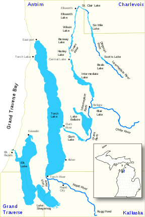
Цепочка водоразделения реки реки Элк , широко известная как цепь озер , представляет собой водный путь длиной 75 миль (121 км), состоящий из 14 озер и соединяющих рек в северо-западной части нижнего полуострова США штата Мичиган , штат Мичиган . который опустошил в озеро Мичиган .
Водораздел включает в себя 500 квадратных миль (1300 км 2 ) в округах Антрим , Чарлевуа , Гранд Траверс и Калкаска . Водораздел включает в себя серию из 14 озер и взаимосвязанных рек. С самого верхнего озера в цепи, озеро Билс в поселке Эхо , округ Антрим, вода течет 55 миль (89 км) и падает на 40 футов (12 м) на высоте. У него более 200 миль (320 км) береговой линии и почти 60 квадратных миль (160 км 2 ) поверхности воды. [ 1 ] [ 2 ]
География
[ редактировать ]The chain of lakes system begins with the upper stage of the Intermediate River, which rises in hill country at 45 ° 00′20 ″ N 85 ° 04′45 ″ W / 45,00556 ° N 85,07917 ° W [ 3 ] в северо -западном углу городка Честония в Центральном округе Антрим. Отсюда водный путь пересекает ряд небольших озер, текущих на север, затем делает резкий поворот возле деревни Эллсворт , течет на юг через узкую долину, параллельно следам железной дороги Пере Маркетт , пока не опустошит в промежуточное озеро. Выход промежуточного озера сходится с рекой Сидар в деревне Беллайр , набирая значительный объем. В настоящее время река существенного потока, она продолжается на юге до 1700 акров (6,9 км 2) Lake Bellaire. Leaving the lake, the stream becomes the Grass River, winding for some two miles (3.2 km) through the scenic Grass River Natural Area before emptying into Clam Lake. Clam Lake in turn empties directly into Torch Lake. At over 18,000 acres (73 km2) in size, Torch Lake is the largest body of water in the system. The waterway, now clarified after traversing the immense depths of the lake, continues south through the Torch River, joins with the Rapid River, a major tributary, and empties into Lake Skegemog, a 2,500-acre (10 km2) lake that is studded with large stump fields, the result of the flooding of timberlands when the lake level was raised several feet by the construction of the dam at the terminus of the system. Lake Skegemog, which is the meeting point of Grand Traverse, Kalkaska and Antrim counties, is conjoined at its western end to 7,700-acre (31 km2) Elk Lake, the second-largest and final lake in the system. The outflow of Elk Lake, the Elk River, flows a short distance to a power dam in the town of Elk Rapids, then out into the east arm of the Grand Traverse Bay of Lake Michigan at 44°54′06″N 85°24′49″W / 44.90167°N 85.41361°W.[4] В течение большей части своей длины цепь навигается на маленькой лодке, разбитой только плотиной в Белле. Большие лодки способны перемещаться между Elk Rapids и Torch Lake.
History
[edit]Various tribes of primarily Ojibwa Native Americans inhabited the region when the first white settlers began to arrive in the middle of the 19th century to attempt farming. The thin soils and short, cool summers made traditional farming difficult, and the region remained sparsely settled until the 1880s, when lumber interests began exploiting the region's vast tracts of white pine forests. The waterway provided an excellent means of transporting logs down to sawmills located along the way. The arrival of the railroads in the 1890s accelerated lumbering and other economic activities, and brought in visitors from distant places, who marveled at the natural beauty of lakes and rivers of the chain, turning it into a major destination for vacationers from downstate and elsewhere. Scores of resorts cropped up on the shorelines of all the major lakes of the system, catering to fisherman and wild-life enthusiasts. By 1910, the lumber era had all but passed, and many once prosperous towns and villages in the area went into decline. Many of the region's farmers, having failed to get decent yields of traditional crops, either moved on, or turned to cultivation of fruit crops, most notably cherries, as the area's sandy soil and cool lake climate were found to be favorable for growing such produce. Fruit farming and tourism became, and remain, the leading economic activities of the region.
Rivers and lakes in the watershed
[edit]The 14 lakes (numbered) and connecting waterways in the chain of lakes are highlighted in bold. Other tributaries are in normal text
- Elk River[4]
- 1) Elk Lake[5]
- Williamsburg Creek[6]
- Battle Creek[9]
- 2) Lake Skegemog[10]
- Barker Creek[11]
- Desmond Creek[12]
- Torch River[13]
- Rapid River[14]
- Rugg Pond (also known as Antrim Pond)[15]
- 3) Torch Lake[17]
- Spencer Creek[18]
- Eastport Creek[19]
- Wilkinson Creek (also Wilkenson Creek)[20]
- 4) Clam Lake[21]
- Finch Creek[22]
- Crow Creek[23]
- Grass River[24]
- Cold Creek[25]
- Shanty Creek[26]
- 5) Lake Bellaire[27]
- Grass Creek[28]
- Intermediate River[3]
- Cedar River[29]
- 6) Intermediate Lake[33]
- Finch Creek[22]
- Rapid River[14]
- 1) Elk Lake[5]
Cities, villages, and townships in the watershed
[edit]The Elk River Chain of Lakes Watershed includes all or portions of the following cities, villages, and townships:
See also
[edit]References
[edit]- ^ "Elk River Chain of Lakes Watershed Project – CMI" (PDF).
- ^ Elk River Chain of Lakes Archived 2011-07-28 at the Wayback Machine, 2010 Report, Tip of the Mitt Watershed Council
- ^ Jump up to: a b c "Intermediate River". Geographic Names Information System. United States Geological Survey, United States Department of the Interior.
- ^ Jump up to: a b "Elk River". Geographic Names Information System. United States Geological Survey, United States Department of the Interior.
- ^ "Elk Lake". Geographic Names Information System. United States Geological Survey, United States Department of the Interior.
- ^ "Williamsburg Creek". Geographic Names Information System. United States Geological Survey, United States Department of the Interior.
- ^ "Bissell Pond". Geographic Names Information System. United States Geological Survey, United States Department of the Interior.
- ^ "Bissell Creek". Geographic Names Information System. United States Geological Survey, United States Department of the Interior.
- ^ "Battle Creek". Geographic Names Information System. United States Geological Survey, United States Department of the Interior.
- ^ "Lake Skegemog". Geographic Names Information System. United States Geological Survey, United States Department of the Interior.
- ^ "Barker Creek". Geographic Names Information System. United States Geological Survey, United States Department of the Interior.
- ^ "Desmond Creek". Geographic Names Information System. United States Geological Survey, United States Department of the Interior.
- ^ "Torch River". Geographic Names Information System. United States Geological Survey, United States Department of the Interior.
- ^ "Rapid River". Geographic Names Information System. United States Geological Survey, United States Department of the Interior.
- ^ "Rugg Pond". Geographic Names Information System. United States Geological Survey, United States Department of the Interior.
- ^ "Little Rapid River". Geographic Names Information System. United States Geological Survey, United States Department of the Interior.
- ^ "Torch Lake". Geographic Names Information System. United States Geological Survey, United States Department of the Interior.
- ^ "Spencer Creek". Geographic Names Information System. United States Geological Survey, United States Department of the Interior.
- ^ "Eastport Creek". Geographic Names Information System. United States Geological Survey, United States Department of the Interior.
- ^ "Wilkinson Creek". Geographic Names Information System. United States Geological Survey, United States Department of the Interior.
- ^ "Clam Lake". Geographic Names Information System. United States Geological Survey, United States Department of the Interior.
- ^ "Finch Creek". Geographic Names Information System. United States Geological Survey, United States Department of the Interior.
- ^ "Crow Creek". Geographic Names Information System. United States Geological Survey, United States Department of the Interior.
- ^ "Grass River". Geographic Names Information System. United States Geological Survey, United States Department of the Interior.
- ^ "Cold Creek". Geographic Names Information System. United States Geological Survey, United States Department of the Interior.
- ^ "Shanty Creek". Geographic Names Information System. United States Geological Survey, United States Department of the Interior.
- ^ "Lake Bellaire". Geographic Names Information System. United States Geological Survey, United States Department of the Interior.
- ^ "Grass Creek". Geographic Names Information System. United States Geological Survey, United States Department of the Interior.
- ^ "Cedar River". Geographic Names Information System. United States Geological Survey, United States Department of the Interior.
- ^ "Blair Lake". Geographic Names Information System. United States Geological Survey, United States Department of the Interior.
- ^ "North Branch Cedar River". Geographic Names Information System. United States Geological Survey, United States Department of the Interior.
- ^ "Woolcott Creek". Geographic Names Information System. United States Geological Survey, United States Department of the Interior.
- ^ «Промежуточное озеро» . Географические имена информационная система . Геологическая служба США , Министерство внутренних дел США .
- ^ "Openo Creek" . Географические имена информационная система . Геологическая служба США , Министерство внутренних дел США .
- ^ "Fisk Creek" . Географические имена информационная система . Геологическая служба США , Министерство внутренних дел США .
- ^ "Hanley Lake". Geographic Names Information System. United States Geological Survey, United States Department of the Interior.
- ^ "Green River". Geographic Names Information System. United States Geological Survey, United States Department of the Interior.
- ^ "Ogletree Creek". Geographic Names Information System. United States Geological Survey, United States Department of the Interior.
- ^ "Kitty Ann Creek". Geographic Names Information System. United States Geological Survey, United States Department of the Interior.
- ^ "Toad Lake". Geographic Names Information System. United States Geological Survey, United States Department of the Interior.
- ^ "Toad Creek". Geographic Names Information System. United States Geological Survey, United States Department of the Interior.
- ^ "Mud Lake". Geographic Names Information System. United States Geological Survey, United States Department of the Interior.
- ^ "Little Torch Lake". Geographic Names Information System. United States Geological Survey, United States Department of the Interior.
- ^ "Ben-way Lake". Geographic Names Information System. United States Geological Survey, United States Department of the Interior.
- ^ "Benway Creek". Geographic Names Information System. United States Geological Survey, United States Department of the Interior.
- ^ "Wilson Lake". Geographic Names Information System. United States Geological Survey, United States Department of the Interior.
- ^ "Vonstraten Creek". Geographic Names Information System. United States Geological Survey, United States Department of the Interior.
- ^ "King Creek". Geographic Names Information System. United States Geological Survey, United States Department of the Interior.
- ^ "Eaton Lake". Geographic Names Information System. United States Geological Survey, United States Department of the Interior.
- ^ "Ellsworth Lake". Geographic Names Information System. United States Geological Survey, United States Department of the Interior.
- ^ "Skinner Creek". Geographic Names Information System. United States Geological Survey, United States Department of the Interior.
- ^ "Skinner Lake". Geographic Names Information System. United States Geological Survey, United States Department of the Interior.
- ^ "Marion Creek". Geographic Names Information System. United States Geological Survey, United States Department of the Interior.
- ^ "St. Clair Lake". Geographic Names Information System. United States Geological Survey, United States Department of the Interior.
- ^ "St. Clair Creek". Geographic Names Information System. United States Geological Survey, United States Department of the Interior.
- ^ "Lyman Creek". Geographic Names Information System. United States Geological Survey, United States Department of the Interior.
- ^ "Lymans Lake". Geographic Names Information System. United States Geological Survey, United States Department of the Interior.
- ^ "Sixmile Lake". Geographic Names Information System. United States Geological Survey, United States Department of the Interior.
- ^ "Liscon Creek". Geographic Names Information System. United States Geological Survey, United States Department of the Interior.
- ^ "Ranney Creek". Geographic Names Information System. United States Geological Survey, United States Department of the Interior.
- ^ "Vance Creek". Geographic Names Information System. United States Geological Survey, United States Department of the Interior.
- ^ "Dingman River". Geographic Names Information System. United States Geological Survey, United States Department of the Interior.
- ^ "Smith Creek". Geographic Names Information System. United States Geological Survey, United States Department of the Interior.
- ^ "Scotts Lake". Geographic Names Information System. United States Geological Survey, United States Department of the Interior.
- ^ "Beal Creek". Geographic Names Information System. United States Geological Survey, United States Department of the Interior.
- ^ "Beals Lake". Geographic Names Information System. United States Geological Survey, United States Department of the Interior.
- ^ "Spence Creek". Geographic Names Information System. United States Geological Survey, United States Department of the Interior.
- ^ "Тейлор -Крик" . Географические имена информационная система . Геологическая служба США , Министерство внутренних дел США .
- ^ "Seamon Creek" . Географические имена информационная система . Геологическая служба США , Министерство внутренних дел США .
- ^ "Хичкок -Крик" . Географические имена информационная система . Геологическая служба США , Министерство внутренних дел США .
Внешние ссылки
[ редактировать ]- Водораздел реки Элк , кончика Совета по водоснабжению рукавицы
- Цепочка реки озер, штат Мичиган , Департамент качества окружающей среды Мичигана
| Центральные города | |
|---|---|
| Округа | |
| География | |
| Транспорт | |
| Экономика | |