Северный Мичиган

Северный Мичиган Северный Нижний Мичиган | |
|---|---|
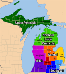 Северный Мичиган выделен светло-зеленым цветом. | |
| Страна | |
| Состояние | |
| Крупнейший город | Траверс-Сити |
| Население | |
| • Общий | 506,658 |
| Часовой пояс | Восточное: UTC −5/−4. |
Северный Мичиган , также известный как Северный Нижний Мичиган известный в просторечии жителям более южных частей штата и дачникам из таких городов, как Детройт, как «Верхний Север» ) — регион американского штата Мичиган ( . Популярное туристическое направление, здесь расположено несколько малых и средних городов, обширные государственные и национальные леса, озера и реки, а также большая часть береговой линии Великих озер . В регионе проживает значительное сезонное население, как и в других регионах, основная отрасль экономики которых зависит от туризма. Северный Нижний Мичиган отличается от более северных Верхнего полуострова и острова Рояль , которые также расположены в «северном» Мичигане. В самых северных 21 округах Нижнего полуострова Мичигана общая численность населения региона составляет 506 658 человек. [А]
История [ править ]
Доколониальная эпоха: индейские странствующие племена
![Карта, показывающая приблизительное расположение основных племен и поселений около 1648 года[1]](http://upload.wikimedia.org/wikipedia/commons/thumb/4/49/Beaver_wars_map.jpg/600px-Beaver_wars_map.jpg)
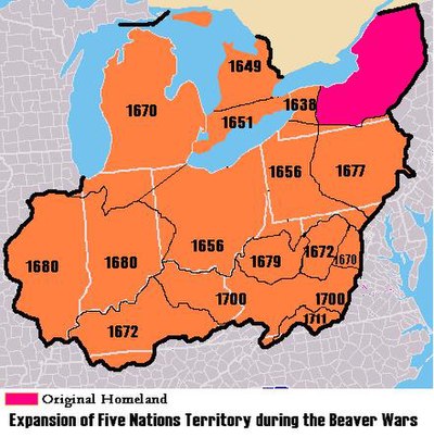
За тысячи лет до того, как французы и англичане основали колонии в этом регионе, Северный Мичиган был населен индейскими культурами и последующими племенами. Северный Мичиган был южной границей территории, населенной, по мнению ученых, доисторическими обитателями, известными как комплекс Лорел . Они были частью индейской обменной системы Хоупвелл, названной в честь доисторического племени , существовавшего в районе Великих озер . [2]
Согласно традиции меномини , первоначальная родина этого племени находилась дальше на север, недалеко от современного Су-Сент. Мари и Мичилимакинак. За какой-то период до контакта с европейцами (вероятно, около 1600 г.) они были вынуждены на юго-запад, к реке Меномини, из-за прибытия оджибве, одава и потаватоми с востока. [3] В истории Одава , написанной Эндрю Блэкбердом, зафиксировано, что округ Эммет был густо населен расой индейцев, которую они называли Муш-ко-деш , что означает «прерийное племя». У Муш-ко-деш было аграрное общество, и, как говорят, они «сформировали землю, превратив лес в прерию, когда они отказались от своих старых изношенных садов, которые образовывали травянистые равнины». Оттавская традиция утверждает, что они убили от сорока до пятидесяти тысяч муш-ко-деш и изгнали остальных с земли после того, как муш-ко-деш оскорбили военный отряд Оттавы. В это же время районы, окружающие Макинакский пролив, были домом для Мичинамакинаго. [4] Это была раса туземцев небольшого роста, которая была почти истреблена ирокезами в 1640-х годах во время Бобровых войн. Остатки этой расы были приняты оджибве и до сих пор существуют среди племен макинаков индейцев чиппева и оттава . [5]
В тот исторический период народы, говорящие на анисинаабе / алгонкинском языке, известные как оджибве , одава и потаватоми , сформировали свободную конфедерацию, которую они назвали Советом Трех Огней . Они населяли районы, окружающие пролив Макинак, верхние и нижние полуострова Мичигана, а также северные острова и береговую линию Канады вдоль озера Гурон.
проливах колониальные эпохи: торговля мехом и исследования в Французская и английская

Initial colonial influence on Natives: French exploration and Beaver Wars[edit]
In 1608, Samuel de Champlain established Quebec as part of New France. He sent coureur des bois such as Étienne Brûlé into the woods to establish relations with the Indians. Around 1615 or 1616, Champlain traveled to Georgian Bay via the French River and met Ottawa and Huron Indians on the south end near Penetanguishene.[7][8][9][10] The French established the North American fur trade with Indian tribes. In the decades that followed, French explorers and missionaries continued to explore the "Upper Country" of New France that included the Upper Great Lakes. In 1634, Jean Nicolet passed through the straits of Mackinac on the way to Wisconsin.[11] While France colonized the interior lands along the St. Lawrence River, the Dutch and English began colonizing the East Coast of North America, setting up fur trade and arming the Iroquois along the east and southeast of the Great Lakes. Competition for trade and pelts resulted in the brutal Beaver Wars. The Iroquois pushed west into the Great Lakes territory, displacing the tribes who had settled there before. As a result of an Iroquois attack and dispersal of the Huron from Southern Ontario in 1649, the Huron sought refuge with the Ojibwe at Michilimackinac where eventually a Jesuit mission was established for their care.[12]
Jesuit Mission at St. Ignace (1671–1696)[edit]

Jesuit Father Marquette set up a mission in St. Ignace in 1671. While the Beaver Wars raged on, Marquette evangelized the Indians. From May 17, 1673, until Marquette's death near Ludington on May 18, 1675, Father Marquette and Louis Jolliet explored and mapped Lake Michigan and the northern portion of the Mississippi River. In 1679, René-Robert Cavelier, Sieur de La Salle and Father Louis Hennepin set out on Le Griffon to find the Northwest Passage; it was the first known sailing ship to sail in Northern Michigan. They sailed across Lake Erie, Lake Huron, and Lake Michigan through uncharted waters, which previously only men in canoes had explored. After Marquette's death, the mission was taken over by Father Phillip Pierson, and then Father Nouvel.[14]
Father Henri Nouvel was "Superior of the Otawa missions",[15] Nouvel served in this position from 1672 to 1680 (with a two-year break in 1678–1679), and again from 1688 to 1695.[16] Under Nouvel, a new chapel was built in approximately 1674. By 1683 the mission was so successful and prosperous that three priests, Fathers Nicholas Potier, Enjalran, and Pierre Bailloquet, were assigned there.[14] The establishment of a French garrison at St. Ignace in 1679 disrupted relations between the French and the local population, as the soldiers were less educated and amiable than the missionaries.
1680s: Fortification (Fort de Buade) at St. Ignace[edit]
In 1683, Governor Joseph-Antoine de La Barre ordered Daniel Greysolon, Sieur du Lhut and Olivier Morel de La Durantaye to establish a strategic presence on the north shore of the Straits of Mackinac, which connected Lake Michigan and Lake Huron of the Great Lakes. They fortified the Jesuit mission at St. Ignace and La Durantaye settled in as overall commander of the French forts in the northwest: Fort Saint Louis des Illinois (Utica, Illinois); Fort Kaministigoya (Thunder Bay, Ontario); and Fort la Tourette (Lake Nipigon, Ontario). He was also responsible for the region around Green Bay in present-day Wisconsin. In the spring of 1684, La Durantaye led a relief expedition from Saint Ignace to Fort Saint Louis des Illinois, which had been besieged by the Seneca (part of the Iroquois Confederacy) as part of the Beaver Wars; they sought to gain more hunting grounds in order to control the lucrative fur trade. That summer and again in 1687, La Durantaye led coureurs de bois and Indians from the Straits against the Seneca homeland in the territory of western upper New York state. During these years, English traders from New York penetrated the Great Lakes and also traded at Michilimackinac. This, and the outbreak of war between England and France in 1689, led to the new commandant Louis de La Porte de Louvigny directing construction of Fort de Buade in 1690.
1690s: Cadillac at Fort de Buade; St. Ignace Fort and Mission later abandoned[edit]
In the 1690s, commander Antoine de la Mothe Cadillac used Fort de Buade as a base of operations to explore and map the Great Lakes. Cadillac left St. Ignace in 1697 and the Jesuits vacated their residence and church by 1705.[17]
The Beaver Wars ended when the Great Peace of Montreal was signed in 1701 in Montreal by the French and 39 Indian chiefs including Kondiaronk (the chief of the Mackinaw-area Huron). When Antoine Laumet de La Mothe, sieur de Cadillac left the area in 1701 to found Detroit, taking many of the St. Ignace residents with him, the importance of the mission declined dramatically.[14]
Early 1700s: Fort Michilimackinac established as a New France outpost[edit]


The St. Ignace Mission remained open until 1705, when it was abandoned and burned by Father Étienne de Carheil.[18] It was reopened in 1712, and operated on the north shore of the Straits until 1741, when it was relocated to the south shore.[19] With the relocation of the mission, the exact location of Marquette's chapel was lost.[18]
In 1712, at the beginning of a 25-year war between the French and the Fox tribe, Canadian Governor Philippe de Rigaud de Vaudreuil sent Constant le Marchand de Lignery to reoccupy the former post of Michilimackinac, which had been abandoned in 1696 by royal orders.
Around 1715 (during the First Fox War), the French re-established a Northern Michigan military outpost at a new site on the northern tip of the lower peninsula and called it Fort Michilimackinac. This location became the new locus for fur and other trade, and mission work with the natives.
Lignery returned to the command of Michilimackinac in 1722 after an absence of about three years fighting the Fox in Illinois. He carried out the orders of acting Governor Charles Le Moyne de Longueuil and (starting in 1726) New France governor Charles de la Boische, Marquis de Beauharnois.
From 1720 to 1722, Pierre François Xavier de Charlevoix stopped at Michilimackinac and other points in Northern Michigan while seeking a Pacific Ocean passage. In 1728, fur trader Augustin Langlade obtained a fur trading license at Michilimackinac. He and his half-Ottawa son Charles Michel de Langlade (born at the fort in 1729) would later strongly influence the Northern Michigan fur trade as well as French relations with Great Lakes tribes during the 1712 to 1733 Fox Wars and the 1754–1763 French and Indian War.
By 1745, the Odawa had created settlements down the coast of Lake Michigan into the Grand Traverse Bay area, with an approximate population between 1,550 and 3,000. This population varied with the seasons, as the tradition was to migrate inland to different camps (sometimes as far as to Illinois) depending upon the season.[20] Some Ojibwe bands also shared the Grand Traverse Bay region with the Odawa.[20]
In 1751, a Jesuit Mission to the Odawa was established in Manistee.[21]
1760s: Beginning of the British era[edit]
In the 1760s after defeating the French in the French and Indian War (and in the Seven Years' War in Europe), the British took control of the Straits of Mackinac and other French territory east of the Mississippi River. They encountered resistance from the Natives, who rose up in what was called Pontiac's War (1763–1766). On June 2, 1763 Ojibwe and Sauk warriors killed the majority of white residents at Fort Michilimackinac. Alexander Henry the elder, one of the survivors, was taken captive and transported to Beaver Island but was rescued by the Odawa Wawatam. The British built the more substantial Fort Mackinac at the site in 1780.[22][23]
The success of rebels in the American Revolutionary War led to another change in parties in the region. Great Britain formally ceded Fort Mackinac at Mackinac Island to the newly independent United States in the Treaty of Paris in 1783, but the British Army refused to evacuate the posts on the Great Lakes until 1796. At that time, they transferred the forts at Detroit, Mackinac, and Niagara to the Americans. British and American forces contested the area again throughout the War of 1812. The boundary was not settled until 1828, when Fort Drummond, a British post on nearby Drummond Island, was evacuated.
1780s to 1830s: United States territorial acquisition, continued fur trade, and territorial disputes[edit]
The entire Straits area was officially acquired by the United States from the British through the Treaty of Paris in 1783 and settlement permitted by the Northwest Ordinance of 1787. However, much of the British forces did not leave the Great Lakes area until after 1794, when Jay's Treaty established U.S. sovereignty over the Northwest Territory with Northern Michigan part of "Knox County".[24] Between 1795 and 1815 a system of Métis (descendants of indigenous women who married French (and later Scottish) fur trappers and traders) settlements and trading posts was established throughout Michigan, Wisconsin, and to a lesser extent in Illinois and Indiana. As late as 1829 the Métis were dominant in the economy of Wisconsin and influential in Northern Michigan[25] in part because they were able to work as intermediaries between natives and white fur traders. US settlement of the Michigan Territory (established in 1805) was punctuated by misunderstandings with Native Americans over land ownership. Meanwhile, in 1804, Mackinac Island was the center of the American fur trade.[26] Gurdon Saltonstall Hubbard was one of many of John Jacob Astor's trappers and voyageurs[27] who plied the waters of the Great Lakes in Mackinaw boats and collected pelts to be sold in Europe.[28] As US Congress passed trade and intercourse acts to regulate trade with the natives, the Office of Indian Trade established a US Trading Post "factory" at Mackinaw that was in place until the War of 1812.[29][30] One of the first engagements of the War of 1812, the Siege of Fort Mackinac was conducted by British and Native American. They captured the island soon after the outbreak of war between Britain and the United States. Encouraged by the easy British victory, more Native Americans subsequently rallied to their support. Native American cooperation was an important factor in several British victories during the remainder of the war. For the rest of 1812 and 1813, the British hold on Mackinac was secure since they also held Detroit, the territorial capital, which the Americans would have to recapture before attacking Mackinac. After the September 1813 Battle of Lake Erie, the British abandoned Detroit leaving an opportunity for the Americans try to retake the waters of Northern Michigan. In July 1814, as Commander of Fort Mackinaw Robert McDouall was struggling to supply war efforts Siege of Prairie du Chien, Americans attacked Mackinaw in July 1814 during the Battle of Mackinac Island. The Americans failed to take over the post, and the British held Mackinac Island until the peace in 1815, after which it was re-occupied by the US.[31][32]
Mackinac Island continued to be a locus of trade for the American Fur Company and was the site where Army doctor William Beaumont became Post surgeon[33] in 1820[34] and began conducting his famous digestion experiments on 19-year-old Alexis St. Martin between 1822 and 1833.[35][36] Mackinac Island was also the site where Henry Schoolcraft located his US Indian Agent headquarters starting in 1833. Following the 1830 Indian Removal Act, Schoolcraft negotiated the 1836 Treaty of Washington which opened up the land north of Grand Rapids for unequivocal legal ownership and settlement of lands in Northern Michigan, with provision that land sales would provide some monetary means to fund skills training for the Natives to assimilate to "civilized" life.
Despite the presence of fur trade, US military and Indian offices, and various tradesmen, the settled population of Michilimackinac (defined as all the settlements from Saginaw to Green Bay) was between 800 and 1000 for the time period between 1820 and 1840.[37]
Early coastal settlements in the 1830s through 1850s[edit]


Decline of Mackinaw and fur trade[edit]
By the 1840s, the American Fur Company was in steep decline as silk hats replaced beaver hats in European fashion.[38][39] The straits of Mackinac declined in influence as government offices moved towards the capital at Detroit. While fishing slightly increased, the loss of the fur industry dealt a blow to Michilimackinac's economic significance.[40]
Increased ship traffic along Northern Michigan coasts[edit]
The Erie Canal opened in 1825, allowing settlers from New England and New York to reach Michigan by water through Albany and Buffalo. This route opening and the incorporation of Chicago in 1837,[41] increased Great Lakes steamboat traffic from Detroit through the straits of Mackinac to Chicago.[42][43][44] While the coastal areas were travelled, practically nothing was known about the interior parts of Northern Michigan.[45] When Michigan became a state in 1837, one of its first acts was to name Douglass Houghton as the lead of the Michigan Geological Survey, an effort to understand the geological and mineralogical, zoological, botanical, and topographical aspects of the lesser known parts of Michigan.[46] Early settlers came to the coasts along Northern Michigan, including fishermen, missionaries to the Native Americans, and participants in early Great Lakes maritime industries such as fishing, lighthouses, and cutting cordwood for passing ships. In 1835, Lieutenant Benjamin Poole of the 3rd U.S. Artillery.[47] surveyed a former Indian path between Saginaw and Mackinac that would become known as the Mackinac Trail.
Indian missions[edit]
Missions to Native Americans included Rev. Peter Dougherty[48] and Rev. John Fleming's 1839 Presbyterian mission on the Old Mission Peninsula, William Montague Ferry's Presbyterian-affiliated 1825 Mission House / Mission Church on Mackinac Island, Magdelaine Laframboise and Samuel Charles Mazzuchelli's Catholic Sainte Anne Church on Mackinac Island in 1830, Frederic Baraga Francis Xavier Pierz and Ignatius Mrak's Catholic mission to the people of the Chippewa and Ottawa at L'Arbre Croche and Peshawbestown (on the Leelanau Peninsula), Peter Greensky's Methodist Greensky Hill church founded near the Little Traverse Bay in 1844, and an 1848 congregationalist mission founded by Chief Peter Waukazoo and Reverend George Smith in Northport (on the Leelanau Peninsula). The Strangite Mormon community move to Beaver Island in 1848 [49] brought additional conflicts as the Mormon leaders sought to enforce laws and restrict use of alcohol on the Beaver Archipelago.[50]
Fishing settlements[edit]
Key fishing settlements included "Fishtown" in Leland, Michigan, and the Beaver Island Archipelago.
Lighthouses[edit]
Early Northern Michigan lighthouses included Thunder Bay Island Light (1831), Old Presque Isle Light (1840), South Manitou Island Lighthouse (1840), DeTour Reef Light (1847), Waugoshance Light (1851), Grand Traverse Light (1852), Tawas Point Light (1853), Beaver Island Harbor Light (1856), Beaver Island Head Light (1858), and Point Betsie Light (1858).
While the United States Lifesaving Service did not establish a system of Great Lakes Lifeboat stations on the Great Lakes until the 1870s,[51] some volunteer stations, such as the North Manitou Island Lifesaving Station were created as early as 1854.
Tension between White settlement and Native American land claims[edit]
In the 1836 Treaty of Washington, Michigan tribes ceded claims to land in Northern Michigan—and opened it to settlement. In the 1840s, Odawa villages lined the Lake Michigan shore, especially from present-day Harbor Springs to Cross Village. The area on the tip of the peninsula was mostly reserved for native tribes by treaty provisions with the U.S. federal government until 1875. Early government had been centered around Mackinac Island and St. Ignace, but between 1840 and 1853, the state broke up this single large Michilimackinac County[52][53][54][55] and established names and boundaries of about 21 counties across Northern Michigan. This naming and surveying allowed specific platted lands to be sold at the Land Office.[56] Increased white immigration and homesteading in Northern Michigan brought difficulties in dispatching of Native American land claims stemming from the treaty of 1836. Bands of Chippewa and Odawa Indians sought redress through the Treaty of 1855;[57] by this 1855 treaty agreement, lands and payments would be set aside for individual Native American families related to the 1836 treaty, but after this treaty, the US would cease to owe anything ("land, money or other thing guaranteed to them") to Indians or their tribes.[58]
1860s to 1890s: Homestead Act settlements and industrial developments[edit]

Increased settlement and establishment of port cities[edit]
Now that the land was surveyed and outstanding native land claims eliminated, Northern Michigan settlement increased even further. The Homestead Act of 1862 brought many Civil War veterans and speculators to Northern Michigan, by making 160 acre tracts of land available for $1.25 an acre.[59] The cutting of wood for passing ships morphed into a full-fledged lumber industry, contributing to the rise of port cities like Manistee, Traverse City, Charlevoix, and Ludington.
1870s: Arrival of rail infrastructure, rampant lumbering and fishing, and economic slowdown[edit]
Starting in the 1870s, railroads were built connecting Northern Michigan to larger industrial areas to the south. The Grand Rapids and Indiana Railroad reached Traverse City in December 1872 (via Walton Junction and Traverse City Rail Road Company) and reached Petoskey (known up to that point as "Bear River") in 1873.[61] The Flint and Pere Marquette Railroad completed its terminal at Ludington in 1874. While the Michigan Central Railroad reached Otsego County in the fall of 1872,[62] rail investments slowed for several years due to the financial panic of 1873 and the ensuing five year economic slowdown. Cheboygan and [63] Mackinaw City did not have rail service until the early 1880s.[64]
Despite setbacks from the Great Michigan Fire in 1871 in Manistee and other lumbering ports, lumbering in Northern Michigan greatly increased. New mechanical tools such as steam-powered (versus water-powered) sawmills and circular saws expanded the ability to process high volumes of lumber quickly. Narrow-gauge moveable rails made it possible to harvest timber year round, in previously inaccessible places away from rivers.[65] The Michigan lumber market experienced a crash in July 1877 [66][67] that coincided with the Great Railroad Strike of 1877. By 1880 the Great Lakes region would dominate logging, with Michigan producing more lumber than any other state.[68]
The commercial fishing industry also flourished in the 1880s. By 1881, the rich fishing areas around the Beaver Archipelago led to Beaver Island becoming the largest supplier of fresh-water fish in the United States.[69] By 1886, there was a drastic reduction in the amount of fishing produced, due to overfishing.[70] In 1893, the Michigan Fish Commission commissioned the University of Nebraska Zoologist Henry Ward to study the sources of food for Traverse Bay area fish.[71]

The passenger pigeon was hunted in Northern Michigan as a source of food, but by the 1870s, a combination of increased population and economic scarcity led to over-hunting and eventual extinction. The massive flocks of passenger pigeons stopped darkening the skies of Northern Michigan, especially after the last large scale nestings and subsequent slaughters of millions of birds in 1874 and 1878. By this time, large nestings only took place in the north, around the Great Lakes. The last large nesting was in Petoskey, Michigan, in 1878 (following one in Pennsylvania a few days earlier), where 50,000 birds were killed each day for nearly five months. The surviving adults attempted a second nesting at new sites, but were killed by professional hunters before they had a chance to raise any young. Scattered nestings were reported into the 1880s, but the birds were now weary, and commonly abandoned their nests if persecuted.[72]
1880s: Emergence of resort and vacation industry[edit]
Rail connections to the large midwestern cities through rail centers like Kalamazoo led to settlers immigrating and wealthy resorters establishing summer home associations in Bay View Association near Petoskey, the Belvedere Club in Charlevoix, and other lakeside getaways. Starting in 1875 (until 1895) the 1,044-acre (422 ha) Mackinac National Park became the second National Park in the United States after Yellowstone National Park in the Rocky Mountains.
Sport fishing[edit]


Sport fishing along the Au Sable River became a tourist attraction for wealthy sportsmen from Detroit, Cleveland, Cincinnati, Buffalo, Toledo, Indianapolis, and Chicago.[74] After the Jackson, Lansing and Saginaw Railroad reached Grayling in the late 1870s, it began to advertise hunting and fishing trips in Crawford County, home of the arctic grayling.[74] In the same way, the Grand Rapids and Indiana Railway published a "Guide to the Health, Pleasure, Game and Fishing Resorts of Northern Michigan reached by the Grand Rapids and Indiana Railroad" in 1882.[75] In 1880, Ansel Judd Northrup, a lawyer from New York, published a detailed account of his train trip to fish Northern Michigan, and he assessed the Au Sable, Manistee River, Cheboygan River, Pigeon River, and Jordan River for trout and grayling fishing.[76] The state of Michigan, having created a Board of Fish Commissioners in 1873, stocked rivers with whitefish, black bass, and non-native species such as California salmon, California trout, German carp, and brook trout.[77] The Board of Fish Commissioners created its first fish hatchery at Crystal Springs Creek in Pokagon and shipped rail cars full of small fish to streams across Michigan.[78][79] As the grayling vanished from the Au Sable, Manistee and other rivers, the state propped up the Northern Michigan fishing industry with non-native brook trout, brown trout, and rainbow trout (steelhead).[80] Ultimately, the Arctic grayling that had inhabited much of Northern Michigan[81] was eventually wiped out. The logging practice of using river beds to move logs in the springtime destroyed the breeding grounds for these fish.[82] Before they could recover, non-native sport fish such as brook trout[83] took over the grayling's habitat and made them disappear from northern Michigan.
Industrial growth and diversification[edit]

The effect of rail connections was ultimately transformative; timber and other goods could be produced in the north and shipped to urban markets to the south. Diverse industries developed, such as iron works, tanneries, mills, cement plants, and agricultural enterprises. By 1885, the intense harvesting and export of pine trees led to visible decline in the lumber industry's ability to produce white pine.[84] Logging in Michigan peaked in 1889.[85] Where available, hardwoods and hemlock were harvested, temporarily extending the life of lumbering in the area, especially around East Jordan, the Traverse Bay, and near Crawford County.[86] William Howard White's lumber railroad (Boyne City, Gaylord & Alpena Railroad Company), David Ward's Detroit and Charlevoix Railroad, and the East Jordan and Southern Railroad enabled access to remote timber areas. As lumbering declined, rail lines began to promote Northern Michigan as a "fresh air" resort destination,[87] and the logging companies promoted their cut-over, stump-filled tracts for their agricultural potential.[88]
20th century: resort era[edit]
Early resorts[edit]
The resort era flourished in lakeside areas of Northern Michigan even as the fishing and lumbering industries experienced slow decline. Historian Bruce Catton's memoir Waiting for the Morning Train (1972) documents his personal experiences of early 20th-century life in a small Northern Michigan town as Michigan's logging era was ending.[89] Ernest Hemingway also documented turn-of-the-century life in Northern Michigan through his "Nick Adams" stories; Hemingway's own parents were resorters, wintering in Oak Park, Illinois, but summering in the Windemere cottage on Walloon Lake starting in 1899.[90]


State parks[edit]
As lumbering died down, many parts of Northern Michigan returned to their forested state through conservation efforts. The Huron National Forest was set aside in 1909. and the Manistee National Forest was set aside in 1938. State parks were established as well, to include:
- Interlochen State Park (1917)
- Mitchell State Park (1919)
- Burt Lake State Park (1920)
- Traverse City State Park (1920)
- Orchard Beach State Park (1921)
- Harrisville State Park (1921)
- Hoeft State Park (1922)
- Aloha State Park (1923)
- Straits State Park (1924)
- South Higgins Lake State Park (1927)
- Hartwick Pines State Park (1927)
- Wilderness State Park (1928)[91]
- Cheboygan State Park (1962) [92]
- Negwegon State Park (1962)
- Leelanau State Park (1964)
- North Higgins Lake State Park (1965)
- Clear Lake State Park (1966)
- Tawas Point State Park (1966)
- Petoskey State Park (1970)
- Fisherman's Island State Park (1975)
- Thompson's Harbor State Park (1988)
- Rockport State Park (2012)
Ski resorts[edit]
Hanson Hills in Grayling was the first downhill ski area in Michigan. It opened in 1929 and was served by rail service.[93]Caberfae Peaks Ski & Golf Resort near Cadillac opened in 1938 and was served by rail service. Boyne Mountain Resort opened in 1948. Crystal Mountain in Benzie County opened in 1956. Nub's Nob opened in 1958 near Harbor Springs.
Decline of rail[edit]
As passenger railroad usage ended in the 1960s (due in part to increased automobile travel), aggressive promotion of Northern Michigan by local chambers of commerce led to many of the festivals and attractions that bring visitors north even today.
Geography[edit]
Boundary description[edit]

Residents of Northern Michigan generally consider it to lie between Grayling and the Mackinac Bridge. The southern boundary of the region is not precisely defined. Some residents in the southern part of the state consider its southern limit to be just north of Flint, Port Huron, Grand Rapids, or Mount Pleasant, though those in Northern Michigan refer to this are as Mid Michigan. Others may restrict it to the area north of Bay City and Clare, using US Highway 10 as a reference point, which roughly marks the "fingers" of the mitten-like shape of the Lower Peninsula.[94] The topic of where "Up North" begins is often debated among Michiganders, with there being no definitive answer on the subject.[95]
The 45th parallel runs across Northern Michigan. Signs in the Lower Peninsula that mark that line are at Mission Point Light[96] (just north of Traverse City); Suttons Bay; Cairn Highway in Kewadin;[97] Alba, Michigan, on U.S. 131 Highway (approximately two miles north of County Road 42, with signs on both sides of the highway); Gaylord;[98] Atlanta; and Alpena.[99] These are six of 29 places in the U.S.A. where such signs or monuments are known to exist. One other such sign is in Menominee, Michigan, in the Upper Peninsula.[100]
Definition excludes the Upper Peninsula[edit]
Across the Straits of Mackinac, to the north, west, and northeast, lies the Upper Peninsula of Michigan (the "U.P."). Despite its geographic location as the most northerly part of Michigan, the Upper Peninsula is not usually included in the definition of Northern Michigan (although Northern Michigan University is located in the U.P. city of Marquette), and is instead regarded by Michigan residents as a distinct region of the state, although residents of the Upper Peninsula often say that "Northern Michigan" is not in the Lower Peninsula. They insist the region must only be referred to as "Northern Lower Michigan", and this can sometimes become a topic of contention between people who are from different Peninsulas.[citation needed] The two regions are connected by the 5-mile-long Mackinac Bridge.[101] Those living South of the bridge are known as trolls, while those living above the bridge are yoopers.
Other definitions of Northern Michigan[edit]
All of the northern Lower Peninsula – north of a line from Manistee County on the west to Iosco County on the east (the second orange tier up on the map) – is considered to be part of the Roman Catholic Diocese of Gaylord.[102]
Topography, climate and soil[edit]
The geographical theme of this region is shaped by rolling hills, Great Lakes shorelines including coastal dunes on the west coast, large inland lakes, numerous rivers and large forests. A tension zone is identified running from Muskegon to Saginaw Bay marked by a change in soil type and common tree species.[103] North of the line the historic presettlement forests were beech and sugar maple, mixed with hemlock, white pine, and yellow birch which only grew on moist soils further south. Southern Michigan forests were primarily deciduous with oaks, red maple, shagbark hickory, basswood and cottonwood which are uncommon further north. Northern Michigan soils tend to be coarser, and the growing season is shorter with a cooler climate. Lake effect weather brings significant snowfalls to snow belt areas of Northern Michigan.
Glaciers shaped the area, creating a unique regional ecosystem. A large portion of the area is the so-called Grayling outwash plain, which consists of broad outwash plain including sandy ice-disintegration ridges; jack pine barrens, some white pine-red pine forest, and northern hardwood forest. Large lakes were created by glacial action.[104]
Weather[edit]
The region has the four seasons in their extremes, with sometimes hot and humid summer days (although, mild in comparison to some parts of the south) to subzero days in winter. With the expansive hardwood forest in Northern Michigan, "fall color" tourists are found throughout the area in early to mid-autumn.[105] When the spring rains come, many roads and bridges become impassable due to flooding or muddy to the point a four-wheel drive cannot pass. Snowfall varies throughout the region due to lake-effect snow from the prevailing westerly winds off of Lake Michigan: average yearly snow ranges from 141.4 inches or 3.59 metres in Gaylord to 52.4 inches or 1.33 metres in Harrisville.[106] Both the high and low temperature records for all of Michigan are held by communities in Northern Lower Michigan. The high is 112 °F or 44.4 °C set in Mio on July 13, 1936, and the low is −51 °F or −46.1 °C set in Vanderbilt on February 9, 1934.[107]
Population[edit]


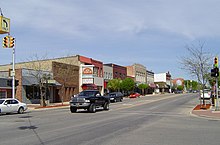


In the northernmost 21 counties in the Lower Peninsula of Michigan, the total population of the region is 506,658 people.[A] The most populated city in Northern Michigan is Traverse City, with over 15 thousand inhabitants. Grand Traverse County is the largest county in Northern Michigan by population, at just under 100,000. Grand Traverse County also contains the three most populous municipalities in Northern Michigan: Garfield Township, Traverse City (which partially extends into Leelanau County), and East Bay Township.
| Municipality | 2020 population | Area (sq mi) | Area (km2) | County(ies) |
|---|---|---|---|---|
| Traverse City | 15,678 | 8.66 | 22.43 | Grand Traverse, Leelanau |
| Cadillac | 10,371 | 8.91 | 23.09 | Wexford |
| Alpena | 10,197 | 9.23 | 23.9 | Alpena |
| Ludington | 8,076 | 3.60 | 9.34 | Mason |
| Manistee | 6,259 | 4.53 | 11.73 | Manistee |
| Petoskey | 5,877 | 5.34 | 13.84 | Emmet |
| Houghton Lake | 5,294 | 7.49 | 19.4 | Roscommon |
| Cheboygan | 4,876 | 6.93 | 17.94 | Cheboygan |
| Gaylord | 4,286 | 5.00 | 12.95 | Otsego |
| Boyne City | 3,816 | 5.34 | 13.84 | Charlevoix |
| Clare | 3,254 | 3.83 | 9.92 | Clare, Isabella |
| Skidway Lake | 3,082 | 11.79 | 30.52 | Ogemaw |
| Gladwin | 3,069 | 2.90 | 7.51 | Gladwin |
| Rogers City | 2,850 | 8.36 | 21.65 | Presque Isle |
| St. Helen | 2,735 | 5.92 | 15.3 | Roscommon |
| East Tawas | 2,663 | 3.27 | 8.48 | Iosco |
| Reed City | 2,490 | 2.13 | 5.53 | Osceola |
| West Branch | 2,351 | 1.53 | 3.97 | Ogemaw |
| Charlevoix | 2,348 | 2.05 | 5.30 | Charlevoix |
| East Jordan | 2,239 | 3.92 | 10.15 | Charlevoix |
| Harrison | 2,150 | 4.03 | 10.43 | Clare |
| Kalkaska | 2,132 | 3.21 | 8.31 | Kalkaska |
| Indian River | 1,950 | 20.2 | 52.4 | Cheboygan |
| Tawas City | 1,834 | 2.13 | 5.51 | Iosco |
| Grayling | 1,867 | 2.08 | 5.39 | Crawford |
| Evart | 1,742 | 2.53 | 6.55 | Osceola |
| Mio | 1,690 | 8.98 | 23.3 | Oscoda |
| Prudenville | 1,643 | 3.62 | 9.4 | Roscommon |
| Elk Rapids | 1,642 | 2.01 | 5.20 | Antrim |
| Greilickville | 1,634 | 7.11 | 18.41 | Leelanau |
| Standish | 1,458 | 2.18 | 5.64 | Arenac |
| Au Sable | 1,453 | 2.13 | 5.52 | Iosco |
| Kingsley | 1,431 | 1.22 | 3.17 | Grand Traverse |
| Rapid City | 1,357 | 5.53 | 14.31 | Kalkaska |
| Mancelona | 1,344 | 1.00 | 2.60 | Antrim |
| Harbor Springs | 1,274 | 1.29 | 3.35 | Emmet |
| Manton | 1,258 | 1.61 | 4.18 | Wexford |
| Frankfort | 1,252 | 1.58 | 4.10 | Benzie |
| Scottville | 1,214 | 1.49 | 3.86 | Mason |
| Beaverton | 1,145 | 1.33 | 3.44 | Gladwin |
| Chums Corner | 1,065 | 2.79 | 2.66 | Grand Traverse |
| Bellaire | 1,053 | 1.99 | 5.16 | Antrim |
| Lakes of the North | 1,044 | 16.73 | 43.44 | Antrim |
The area was populated by many different ethnicities, including groups from New England (Maine, Vermont, New York), Ireland, Germany, and Poland. The Odawa nation is located in Emmet County (Little Traverse Band of Odawa Indians). Other Native American reservations exist at Mount Pleasant and on the Leelanau Peninsula.
Counties[edit]

There are 21 counties traditionally associated with Northern Michigan:
| County | 2020 population | Land area (sq mi) | Land area (km2) | Seat |
|---|---|---|---|---|
| Alcona County | 10,167 | 675 | 1,750 | Harrisville |
| Alpena County | 28,907 | 572 | 1,480 | Alpena |
| Antrim County | 23,431 | 476 | 1,230 | Bellaire |
| Benzie County | 17,970 | 320 | 800 | Beulah |
| Charlevoix County | 25,597 | 416 | 1,080 | Charlevoix |
| Cheboygan County | 26,152 | 715 | 1,850 | Cheboygan |
| Crawford County | 23,988 | 556 | 1440 | Grayling |
| Emmet County | 34,112 | 467 | 1,210 | Petoskey |
| Grand Traverse County | 95,238 | 464 | 1,200 | Traverse City |
| Iosco County | 25,237 | 549 | 1,420 | Tawas City |
| Leelanau County | 22,301 | 347 | 900 | Suttons Bay |
| Kalkaska County | 17,939 | 560 | 1,500 | Kalkaska |
| Manistee County | 25,032 | 542 | 1,400 | Manistee |
| Missaukee County | 15,052 | 565 | 1,460 | Lake City |
| Montmorency County | 9,153 | 547 | 1,420 | Atlanta |
| Ogemaw County | 20,770 | 563 | 1,460 | West Branch |
| Oscoda County | 8,219 | 566 | 1,470 | Mio |
| Otsego County | 25,091 | 514 | 1,330 | Gaylord |
| Presque Isle County | 12,982 | 659 | 1,710 | Rogers City |
| Roscommon County | 23,459 | 520 | 1,300 | Roscommon |
| Wexford County | 33,673 | 565 | 1,460 | Cadillac |
In addition to these 21, six more counties to the south are also occasionally referred to as Northern Michigan, but are generally considered to be part of other regions. This counties are:
| County | 2020 population | Land area (sq mi) | Land area (km2) | Seat |
|---|---|---|---|---|
| Arenac County | 15,002 | 363 | 1,760 | Standish |
| Clare County | 30,856 | 564 | 1,460 | Harrison |
| Gladwin County | 25,386 | 502 | 1,300 | Gladwin |
| Lake County | 12,096 | 567 | 1,470 | Baldwin |
| Mason County | 29,052 | 495 | 1,280 | Ludington |
| Osceola County | 22,891 | 566 | 1,470 | Reed City |
Cities, villages, and unincorporated communities[edit]
Below is a list of cities, villages, and unincorporated communities in northern Michigan:
- Acme (Grand Traverse)
- Afton (Cheboygan)
- Albert (Montmorency)
- Albert (Emmet)
- Aloha (Cheboygan)
- Alpena (Alpena)
- Arlene (Missaukee)
- Atlanta (Montmorency)
- Au Gres (Arenac)
- Barton City (Alcona)
- Bates (Grand Traverse)
- Beaver Island (Charlevoix)
- Beaverton (Gladwin)
- Bear Lake (Manistee)
- Belknap (Presque Isle)
- Benzonia (Benzie)
- Beulah (Benzie)
- Black River (Alcona)
- Boon
- Boyne City (Charlevoix)
- Boyne Falls (Charlevoix)
- Briley (Montmorency)
- Brookside (Grand Traverse)
- Buckley (Wexford)
- Cadillac (Wexford)
- Cedar (Leelanau)
- Central Lake (Antrim)
- Charlevoix (Charlevoix)
- Cheboygan (Cheboygan)
- Custer (Mason)
- Denton (Roscommon)
- East Jordan (Charlevoix)
- East Tawas (Iosco)
- Elberta (Benzie)
- Elk Rapids (Antrim)
- Empire (Leelanau)
- Fairview (Oscoda)
- Falmouth (Missaukee)
- Fife Lake (Grand Traverse)
- Fountain (Mason)
- Frankfort (Benzie)
- Free Soil, Michigan (Mason)
- Gaylord (Otsego)
- Gladwin (Gladwin)
- Glennie (Alcona)
- Glen Arbor (Leelanau)
- Glen Haven (Leelanau)
- Goodar (Ogemaw)
- Good Harbor (Leelanau)
- Grawn (Grand Traverse)
- Grayling (Crawford)
- Greenbush (Alcona)
- Greilickville
- Gustin (Alcona)
- Hale (Iosco)
- Hannah (Grand Traverse)
- Harbor Springs (Emmet)
- Harrietta
- Harrisville (Alcona)
- Hawks (Presque Isle)
- Herron (Alpena)
- Higgins Lake (Roscommon)
- Hillman (Alpena/Montmorency)
- Honor (Benzie)
- Houghton Lake (Roscommon)
- Hubbard Lake (Alcona)
- Indian River (Cheboygan)
- Interlochen (Grand Traverse)
- Kalkaska (Kalkaska)
- Kaleva (Manistee)
- Karlin (Grand Traverse)
- Kingsley (Grand Traverse)
- Lachine (Alpena)
- Lake Ann (Benzie)
- Lake City (Missaukee)
- Lake Leelanau (Leelanau)
- Leland
- Lewiston (Montmorency)
- Lincoln (Alcona)
- Long Rapids (Alpena)
- Lost Lake Woods (Alcona)
- Ludington (Mason)
- Lupton (Ogemaw)
- Mackinac Island (Mackinac)
- Mackinaw City (Cheboygan/Emmet)
- Manistee (Manistee)
- Manton (Wexford)
- Mapleton (Grand Traverse)
- Maple City (Leelanau)
- Maple Ridge (Arenac)
- Mayfield (Grand Traverse)
- McBain (Missaukee)
- Mesick (Wexford)
- Metz (Presque Isle)
- Millersburg (Presque Isle)
- Mikado (Alcona)
- Mio (Oscoda)
- Moltke (Presque Isle)
- Monroe Center (Grand Traverse)
- Mullett Lake (Cheboygan)
- National City (Iosco)
- Northport (Leelanau)
- Ocqueoc (Presque Isle)
- Ogdensburg (Grand Traverse)
- Old Mission (Grand Traverse)
- Omena (Leelanau)
- Omer (Arenac)
- Onaway (Presque Isle)
- Onekama (Manistee)
- Oscoda (Iosco)
- Ossineke (Alpena)
- Palaestrum (Grand Traverse)
- Pellston (Emmet)
- Petoskey (Emmet)
- Posen (Presque Isle)
- Prescott (Ogemaw)
- Presque Isle (Presque Isle)
- Prudenville (Roscommon)
- Rapid City (Kalkaska)
- Richfield (Roscommon)
- Rogers City (Presque Isle)
- Roscommon (Roscommon)
- Rose City (Ogemaw)
- Rust (Montmorency)
- St. Helen (Roscommon)
- Scottville (Mason)
- South Boardman (Kalkaska)
- South Branch (Iosco)
- Spruce (Alcona)
- Standish (Arenac)
- Sterling (Arenac)
- Summit City (Grand Traverse)
- Tawas City (Iosco)
- Thompsonville (Benzie)
- Topinabee (Cheboygan)
- Tower (Cheboygan)
- Traverse City (Grand Traverse/Leelanau)
- Turner (Arenac)
- Twining (Arenac)
- Vanderbilt (Otsego)
- Walhalla (Mason)
- Walton (Grand Traverse/Wexford)
- West Branch (Ogemaw)
- Whittemore (Iosco)
- Wilber (Iosco)
- Williamsburg (Grand Traverse)
- Wolverine (Cheboygan)
- Yuba (Grand Traverse)
Indian reservations[edit]
- Burt Lake Band of Ottawa and Chippewa Indians
- Grand Traverse Band of Ottawa and Chippewa Indians
- Little Traverse Bay Bands of Odawa Indians occupies at least 13 scattered reservation areas within Emmet County, including portions within the city of Petoskey and the townships of Bear Creek, Bliss, Center, Little Traverse, McKinley, Readmond, Resort, Wawatam, and West Traverse.[108]
- Mackinac Bands of Chippewa and Ottawa Indians
Flora and fauna[edit]
Common plants[edit]

Northern Michigan has many tree types including maple, birch, oak, ash, white cedar, aspen, pine, and beech. Ferns, milkweed, Queen Anne's lace, and chicory grow in the open fields and along roadsides. Forest plants include wild leeks, morel mushrooms, and trilliums. Marram grass grows on beaches. Several mosses cover the land.
Common mammals[edit]
Common mammals in Northern Michigan include white-tailed deer, fox, raccoons, porcupines, and rabbits. black bear, elk, coyote, bobcat, wolves, and mountain lions are also present. Although not common, the presence of cougars has been persistently reported over many years.[109][110][111] Fish include whitefish, yellow perch, trout, bass, northern pike, walleye, muskie, and sunfish.
Common birds[edit]
Common birds are ducks, seagulls, wild turkey, great blue herons, northern cardinals, blue jays, black-capped chickadees, hummingbirds, Baltimore oriole, and ruffed grouse. Canada geese may be seen flying over head in spring and fall. Less well known birds that are unique in Michigan to the Northern Lower Peninsula are spruce grouse, sharp-tailed grouse, red-throated loon, Swainson's hawk, and the boreal owl.[112][113]
The Au Sable State Forest is a state forest in the north-central Lower Peninsula of Michigan. Much of the forest is used for wildlife game management and the fostering of endangered and rare species, such as the Kirtland's warbler – there are regular controlled burns to maintain its habitat. The Kirtland's warbler has its habitat in an increasing part of the area.[114] There is a Kirtland's Warbler Festival, which is sponsored in part by Kirtland Community College.[115]
The American Bird Conservancy and the National Audubon Society have designated several locations as internationally Important Bird Areas.[116]
Common insects[edit]
Insect populations are similar to those found elsewhere in the midwestern United States. ladybugs, crickets, dragonflies, mosquitoes, ants, house flies, and grasshoppers are common, as is the Western conifer seed bug, and several kinds of butterflies and moths (for example, monarch butterflies and tomato worm moths). Notable deviations in insect populations are a high population of June bugs during June as well as a scarcity of lightning bugs because of the lower average temperatures year round and especially in the summer.
Northern Michigan is home to Michigan's most endangered species and one of the most endangered species in the world: the Hungerford's crawling water beetle. The species lives in only five locations in the world, four of which are in Northern Michigan (one is in Bruce County, Ontario). Indeed, the only stable population of the rare beetle occurs along a two and a half mile stretch of the East Branch of the Maple River in Emmet County, Michigan.
Common reptiles[edit]
There are no fatally venomous snakes native to Northern Michigan. The venomous Eastern Massasauga Rattlesnake lives in Michigan, but it is not common, particularly in Northern Michigan. In any event, its non-fatal bite may make an adult sick, but it should be medically treated without delay.
Snakes present include the eastern hog-nosed snake, brown snake, common garter snake, eastern milk snake and the northern ribbon snake. The only common reptiles and amphibians are various pond frogs, toads, salamanders, and small turtles.
State Forests and conservation areas[edit]
The state forests in the U.S. state of Michigan are managed by the Michigan Department of Natural Resources, Forest, Mineral and Fire Management unit. It is the largest state forest system in the nation at 3,900,000 acres (16,000 km2). See List of Michigan state forests. The Northern lower peninsula includes three forests:
- Mackinaw State Forest
- Atlanta FMU (Alpena, northeast Cheboygan, most of Montmorency, and most of Presque Isle counties)
- Gaylord FMU (Antrim, Charlevoix, most of Cheboygan, Emmet, and most of Otsego counties)
- Pigeon River Country FMU (southeast Cheboygan, northwest Montmorency, northeast Otsego, and southwest Presque Isle counties)
- Pere Marquette State Forest
- Cadillac FMU (Lake, Mason, Mecosta, Missaukee, Newaygo, Oceana, Osceola, and Wexford counties)
- Traverse City FMU (Benzie, Grand Traverse, Leelanau, Kalkaska, Manistee counties)
- Au Sable State Forest
- Gladwin FMU (Arenac, Bay, Clare, Gladwin, southern Iosco, Isabella, and Midland counties)
- Grayling FMU (Alcona, Crawford, Oscoda, and northern Iosco counties)
- Roscommon FMU (Ogemaw and Roscommon counties)
In addition, large portions of this area are covered by the Manistee National Forest and the Huron National Forest. In the former, a unique environment is present at the Nordhouse Dunes Wilderness. This relatively small area of 3,450 acres (14.0 km2), on Lake Michigan's east shore, is one of few wilderness areas in the U.S. with an extensive lake shore dunes ecosystem. The dunes are 3500 to 4000 years old, and rise to nearly 140 feet (43 m) higher than the lake. The Nordhouse Dunes are interspersed with woody vegetation such as jack pine, juniper and hemlock. Many small water holes and marshes dot the landscape, and dune grass covers some of the dunes. The wide and sandy beach is ideal for walks and sunset viewing.
Eight islands off the Lakes Michigan and Huron coasts – Charlevoix and Alpena counties, respectively – are part of the Michigan Islands National Wildlife Refuge.
Tourism[edit]


Summer destinations[edit]
Boating, golf, and camping are leading activities. Sailing, kayaking,[117] canoeing, birding, bicycling,[118][119][120] horse back riding, motorcycling, and 'off roading' are important avocations. The forest activities are available everywhere. There are a great many Michigan state parks and other protected areas which make these truly a 'pleasant peninsula.' These would include the Huron National Forest and the Manistee National Forest, plus the Sleeping Bear Dunes National Lakeshore (a 35-mile stretch of eastern Lake Michigan dunes)[121] and the Nordhouse Dunes Wilderness.
- Many city dwellers from "downstate" and nearby areas (notably Chicago) have summer vacation homes in Northern Michigan. The largest resort cities in Northern Michigan are in the west on Lake Michigan, with its sandy beaches and warm bays. Popular tourist towns in Northern Michigan include Northport, Traverse City, Elk Rapids, Charlevoix, Boyne City, Petoskey, Manistee, Ludington, Bear Lake, Empire, Frankfort,[122] Harbor Springs, and Leland. It should also be noted that there is a large wine district in the area along the Lake Michigan Shore.
- At the top of the lower peninsula are Mackinaw City, and Mackinac Island[123] (which lies between the Lower and Upper Peninsulas in the Straits of Mackinac).
- Less well known and less developed is the northeastern lower peninsula along the Lake Huron shore. It offers many great vacation spots, particularly along the coast. These are, in order from south-to-north, Standish, Omer, Au Gres, Tawas City, East Tawas, Oscoda, Greenbush, Harrisville, Alpena, Presque Isle, Rogers City, Cheboygan, and points in between. Some consider these to be more 'up north' than the relatively congested west coast. Indeed, the Detroit Free Press noted that the area between Oscoda and Ossineke included beaches that are "overlooked" and among the "top ten in Michigan." This would include the area around Harrisville (and two state parks). It was noted that: "Old-fashioned lake vacations abound on this pretty stretch of Lake Huron."[124]
- In between the two (or three, depending on how you count) coasts, there are a large number of inland cities and lakes (Michigan has 11,037 lakes), and a varied landscape that has many rivers. Such places as Cadillac, Kalkaska, Grayling, West Branch and Gaylord are also prized summer destinations for Michiganders and visitors from other states. Among many others, Houghton Lake, Higgins Lake, Torch Lake, and Hubbard Lake are large inland lakes within the region.
- The Michigan Shore to Shore Riding & Hiking Trail[125] runs from Empire to Oscoda, and points north and south. It is a 240-mile (390 km) interconnected system of trails.
- The Great Lakes Circle Tour is a designated scenic road system connecting all of the Great Lakes and the St. Lawrence River.[126]

Non-summer destinations[edit]
Some of the downhill and Nordic skiing (cross-country) resorts located in the Northern Lower include Boyne Mountain, Boyne Highlands, Otsego Club & Resort (since 1939), Crystal Mountain Resort, Snow Snake Ski and Golf, Nub's Nob, Caberfae Peaks and Schuss Mountain. Some of these also serve as summer golf resorts. Frederic, Michigan, is a particularly noteworthy center for cross country skiing.
Fall activities include harvest festivals, seasonal beer and wine events, and fall color tours. Hunting in Northern Michigan is a popular fall pastime. There are seasons for bow hunting and a muzzle-loader season as well as for using modern rifle season. The opening day of deer season (November 15) is a major day for some residents. Some schools close November 15, due to low attendance as a result of the opening day of deer season.
In winter, a variety of sports are enjoyed by the locals which also draw visitors to Northern Michigan. Snowmobiling, also called sledding, is popular, and with hundreds of miles of interconnected groomed trails cross the region. Ice fishing is also popular. Tip-up Town on Houghton Lake is a major ice-fishing, snowmobiling and winter sports festival, and is unique in that it is a village that assembles out on the frozen lake surface. Higgins Lake also offers good ice fishing and has many snowmobiling, cross country skiing, and snowshoeing trails at the North Higgins Lake State Park. Grayling and Gaylord and their environs are recognized for Nordic skiing. Cadillac is reputed to be even more popular during the winter than it is in the summer.
Other tourist attractions[edit]
- Pierce Stocking Scenic Drive
- Thunder Bay National Marine Sanctuary
- Sleeping Bear Dunes National Lakeshore
- Mackinac Bridge
- Boyne Mountain
- Fort Michilimackinac
- Many State Parks
The Lumberman's Monument honors lumberjacks that shaped the area, exploiting the natural resource. It is located on the River Road National Scenic Byway, which runs parallel with the Au Sable River, and is a designated National Scenic Byway for the 23 miles (37 km) that go into Oscoda.[127] The State of Michigan has designated Oscoda as the official home of Paul Bunyan due to the earliest documented publications in the Oscoda Press, August 10, 1906, by James MacGillivray (later revised and published in The Detroit News in 1910).[128]
Hartwick Pines State Park is a 9,672-acre (39.14 km2) state park and logging museum located in Crawford County near Grayling and I-75. It is the third largest state park on Michigan's Lower Peninsula and the state's fifth-biggest park overall. The park contains an old growth forest of white pines and red pines that resembles the appearance of all of Northern Michigan prior to the logging era. Also to be noted is Interlochen State Park, which is the oldest state park and the other remaining stand of virgin Eastern White Pine in the Lower Peninsula.
The Besser Museum for Northeast Michigan is a community museum serving Alpena County and surrounding counties in the U.S. state of Michigan. Alpena is a port city on Lake Huron. The museum defines its role broadly — to preserve, protect and present history and culture closely connected with the heritage of Northern Michigan and the Great Lakes. The museum includes a small publicly owned planetarium.[129] The institution says "Our mission is to collect, preserve, interpret, and exhibit authentic articles and artifacts of art, history, and science to inspire curiosity, foster community pride, and cultivate personal legacy."[130]
There were more than 150 past and present lighthouses around Michigan's Great Lakes coasts, including several in Northern Michigan. They serve as functioning warnings to mariners, but are also integral to the region's culture and history. See the list of Michigan lighthouses for more information on individual lighthouses.
Festivals[edit]
A number of annual festivals occur in Northern Michigan, including:
| Festival | Location | Remarks and sources |
|---|---|---|
| AlpenFest and Alpenfest run/walk | Gaylord | [131][132] |
| Art on the Beach | Oscoda | [133] |
| Arts and crafts shows around the state | Various | [134] |
| Bass Festival | Mancelona | [135][136] |
| Blissfest (folk festival) | Bliss Township | [137][138] |
| Cadillac Chestnut Harvest Festival | Cadillac | [139] Held every year, on the second Saturday of October[140] |
| Cedar Polka Festival | Cedar | [141] |
| Celebration Days at Tawas Point State Park | East Tawas, Michigan | [142] |
| Charlevoix Waterfront Art Fair | Charlevoix | [143] 2nd weekend in August [citation needed] |
| Chicago Yacht Club Race to Mackinac | Lake Michigan | [144] |
| Dulcimer FunFest | Evart | [145][citation needed] |
| Firemen's Memorial Festival | Roscommon | [146][citation needed] |
| Freedom Festival | East Jordan | [147][citation needed] |
| Great Lakes Bioneers Conference | ??? | [148][citation needed] |
| Great Lakes Lighthouse Festival | Alpena | [149] [citation needed] According to Tim Harrison, Editor in Chief and publisher of Lighthouse Digest magazine, and President of American Lighthouse Foundation, "There is no other festival like it in the United States..."[150] |
| Harrisville Arts & Crafts Show aka "Harmony Weekend"[151] | Harrisville | Labor Day weekend [citation needed] |
| Hoxeyville Music Festival | South Branch Township, Wexford County, Michigan | [152][citation needed] |
| Kirtland Warbler Festival | Roscommon County, Michigan | [153] |
| Leland Wine & Food Festival | Northport | [154][citation needed] |
| Mackinac Island Fudge Festival | Mackinac Island | [155][citation needed] |
| Mackinac Island Lilac Festival | Mackinac Island | [156] [citation needed] |
| Mackinac Island Music Festival | Mackinac Island | [157] [citation needed] |
| Michigan Brown Trout Festival | Alpena | [158][159][160][161] |
| Mushroom Festival | Mesick | [162] [citation needed] |
| National Cherry Festival | Traverse City | [163] |
| National Coho Salmon Festival | Honor | [164][citation needed] |
| National Forest Festival | Manistee | [165] |
| National Morel Mushroom Festival | Boyne City | [166] [citation needed] |
| National Trout Festival | Kalkaska | [167] [citation needed] End of April |
| Nautical Festival | Rogers City | [168] [citation needed] |
| North American Snowmobile Festival | Cadillac | [169] |
| Northport's Harbor Day (and July 4 Celebration) | Northport | [citation needed] |
| Paul Bunyan Festival & Great Lakes Chainsaw Carving Competition | Oscoda | [133] |
| Petoskey Festival on the Bay | Petoskey | [170][citation needed] |
| Polish Festival | Boyne Falls | [171] [citation needed] |
| Port Huron to Mackinac Boat Race | Lake Huron | Ends on Mackinac Island [172] |
| Posen Potato Festival | Posen | [173] |
| Salmon Slam | Northport, Michigan | [citation needed] |
| Scottville Harvest Festival | Scottville | [174] |
| Timberfest | Lewiston | [175] |
| Tip-Up Town (ice fishing festival) | Houghton Lake | [176] [citation needed] |
| Traverse Bay Farms Salsa Bar Festival | Elk Rapids/Bellaire | [177] [citation needed] |
| Traverse City Film Festival | Traverse City | [citation needed] |
| Venetian Festival | Charlevoix | [178] [citation needed] |
| Weyerhauser Au Sable River Canoe Marathon | Grayling to Oscoda | One leg of the "Triple Crown of Canoe Racing". This is one of the few pro-am canoeing events in the U.S., and winning times may be as long as 21 hours.[179][180][181] |
| WinterFest and | Kalkaska | [182] Includes a sled dog race.[183] |
| World Famous Labor Day Fish Boil | Northport, Michigan | [citation needed] |
Economy[edit]
The economy of Northern Michigan is limited by its lower population, few industries and reduced agriculture compared to lower Michigan. Seasonal and tourism related employment is significant. Unemployment rates are generally high. (In June 2007, seven of the ten highest unemployment rates occurred in counties in the Northern Michigan area.[184] Historically, Fur trade, lumbering and commercial fishing were among the most important industries. The fur trade essentially died out in the 1840s. Logging is still important but at a mere fraction of its heyday (1860–1910) output. Commercial fishing is a minor activity.
Vacation and tourism[edit]
A major draw to Northern Michigan is tourism. Real estate, especially condominiums and summer homes, is another significant source of income. Because money spent in the real estate and tourism market in Northern Michigan is dependent upon visitors from southern Michigan and the Chicago area, the Northern Michigan economy is sensitive to downswings in the automobile and other industries.[185]
Agriculture[edit]

Agriculture is limited by the climate and soil conditions compared to southern regions of the state. However, there are significant potato and dry bean farms in the east. Wine grapes, vegetables and cherries are produced in the west in the protected microclimates around Grand Traverse Bay. The Grand Traverse region has two of Michigan's four federally-recognized wine growing areas. The Grand Traverse Bay area is listed as one of the most endangered agricultural regions in the U.S. as its scenic land is highly sought after for vacation homes.
Heavy industry[edit]
Heavy industrial developments are sparse. The northeast corner has an industrial base.
Quarrying and mining[edit]
Cement-making and the mining of limestone and gypsum for Portland Cement are major exports of the area. Charlevoix's Medusa Cement Plant was bought by Cemex in the 1990s. Alpena is home to the Lafarge Company's holdings in the world's largest cement plant and is home to Besser Block Co. (Jesse M. Besser invented concrete block in 1904 and founded the Besser Block Co. in Alpena after making the concrete block making machine). USG Corporation, also known as United States Gypsum Corporation, operates several quarries, including one at Alabaster, and one in Rogers City. Rogers City is the locale of the world's largest limestone quarry, which is also used in steel making all along the Great Lakes.
Energy (oil and natural gas)[edit]

Northern Michigan has significant natural gas reserves along the Antrim shale formation in northern Michigan. By some estimates it is the 15th largest gas field in the nation.[187] Drilling activity peaked in the late 1980s and early 1990s,[188] In 2014, Encana, the Canadian company who had been drilling in Northern Michigan, sold their mineral rights to Marathon Oil order to focus on more profitable operations elsewhere. For oil interest, Encana amassed rights for the Collingwood-Utica Shale (Michigan) between 2008 and 2010, mostly in Cheboygan, Kalkaska, Michigan, and Missaukee counties. The Collingwood layer is two miles below the surface and would require horizontal drilling.[189][190][191]
Manufacturing[edit]
Alpena has a hardboard manufacturing facility owned by Decorative Panels, International. Nearer to the Lake Michigan shore, Cadillac and Manistee have manufacturing and chemical industries. Morton Salt operates one of the largest salt plants in the world in Manistee. Also, the East Jordan Iron Works corporate offices, as well as the original foundry, are located in East Jordan.
Maritime[edit]
A small number of people work on the Great Lakes freighters. Adjacent to the Traverse City Cherry Capital Airport is a United States Coast Guard air station (CGAS), which is responsible for both maritime and land-based search and rescue operations in the northern Great Lakes region.
Military[edit]
Military presence in Northern Michigan is as follows:
- Alpena Combat Readiness Training Center in Alpena, Michigan, is run by the Air National Guard and is co-located with the Alpena County Regional Airport.
- Camp Grayling near Grayling, Michigan. Camp Grayling is the largest military installation east of the Mississippi River, and the nation's largest National Guard training site. It is used by the U.S. National Guard, as well as active and reserve components of the Army, Navy, Air Force and Marine Corps. Year-round training is conducted on its 147,000 acres (590 km2) in Crawford, Kalkaska and Otsego counties. Much of the land (including Lake Margrethe) is accessible to the public for hunting, fishing, snowmobiling and other recreational uses (when military training is not happening).
- Wurtsmith Air Force Base near Oscoda closed in 1993 and has been converted to civilian use as Oscoda-Wurtsmith Airport.
- The Coast Guard has a presence in Charlevoix, Cheboygan, and Traverse City.
Education[edit]
Interlochen Center for the Arts is a notable arts center that offers a high-school-level academy and summer camp near Traverse City. There are also several institutions of higher education in Northern Michigan. Community colleges include North Central Michigan College (NCMC, pronounced "nuck-muck" by locals), Alpena Community College, Huron Shores Campus-Alpena Community College, Kirtland Community College, West Shore Community College, and Northwestern Michigan College (NMC) including the Great Lakes Maritime Academy, the only U.S. maritime academy on freshwater. Northern Michigan has arguably only one four-year university (depending on the definition of the southern boundary of the region), Ferris State University in Big Rapids. Other nearby universities are in the Upper Peninsula (Northern Michigan University and Lake Superior State University), as well as Central Michigan University and Ferris State University in the more southern reaches of the state. The University of Michigan runs the University of Michigan Biological Station out of Pellston, MI. Central Michigan University runs the CMU Biological Station on Beaver Island. Hillsdale College runs the biological station in Lake County.
Many four-year universities located downstate offer bachelor's and master's degree programs through Northwestern Michigan College's unique University Center program, located in Traverse City. The University Center, located in Traverse City, is a joint program with Northwestern Michigan College and various universities around the state that allows local students to "attend" universities that offer bachelor's and master's degrees programs not available through NMC, a two-year college, locally without leaving Northern Michigan. NMC supplies the facilities while the senior universities provide the education and endorsement. Universities offering programs here include Michigan State University, Western Michigan University, Central Michigan University, Grand Valley State University, Ferris State University, Spring Arbor University, and others.[192]
Media[edit]
Northern Michigan is in the Designated Market Areas of "Traverse City-Cadillac" (116), "Alpena" (208), and some portions of "Flint-Saginaw-Bay City" (66).
Newspapers[edit]
- Alcona County Review, Harrisville
- The Alpena News
- Boyne City Gazette
- Cadillac Evening News
- Charlevoix Courier
- Cheboygan Daily Tribune
- Citizen-Journal, Boyne City, East Jordan
- Crawford County Avalanche, Grayling
- Gaylord Herald Times
- Grand Traverse Herald, weekly in Traverse City
- Iosco County News-Herald, Tawas City
- The Leader and the Kalkaskian, Kalkaska
- Leelanau Enterprise, Leland
- Ludington Daily News
- Manistee Daily News Advocate
- Mears News, historical/defunct
- Midland Daily News
- Missaukee Sentinel (Lake City)
- Northern Express Weekly, weekly in Traverse City
- Onaway Outlook
- Oscoda Press
- Petoskey News-Review
- Presque Isle County Advance, Rogers City
- St. Ignace News, serving the Straits area
- The Town Meeting, Elk Rapids
- Traverse City Record-Eagle
- White Pine Press,[193] Northwestern Michigan College
Daily editions of the Detroit Free Press and The Detroit News are also available throughout the area with the Bay City Times and Saginaw News available in the east and The Grand Rapids Press available in the west.
Magazines[edit]
- Traverse is published monthly with a focus on regional interests.
Radio[edit]
FM[edit]
// designates a simulcast.
- 88.5 WIAB Mackinaw City – //88.7 WIAA
- 88.5 WSFP Rust Twp/Alpena – Smile FM
- 88.7 WIAA Interlochen – Classical "IPR Music Radio"
- 89.3 WTLI Bear Creek Twp. (Petoskey) – Contemporary Christian; Smile FM (//88.1 WLGH Lansing)
- 89.7 WJOJ Harrisville/Alpena – Smile FM
- 89.9 WLJN Traverse City – Religious
- 90.5 WPHN Gaylord – Adult Contemporary Christian "The Promise FM"; also airs on 99.7 FM translator in Petoskey
- 90.7 WNMC Traverse City – Variety, College
- 90.9 WTCK Charlevoix – Catholic; also airs on translators 92.1 FM Gaylord/95.3 FM Mackinaw City
- 90.9 WMSD Rose Township (Ogemaw County) – Religious
- 91.1 WOLW Cadillac – //90.5 WPHN
- 91.3 WJOG Good Hart/Petoskey – Smile FM
- 91.3 WZHN East Tawas – //90.5 WPHN
- 91.5 WICA Traverse City – NPR, Public News/Talk
- 91.7 WCML Alpena – Public Music Variety/News/Talk "CMU Public Radio"
- 92.1 WTWS Houghton Lake – Hot Country "92-1 The Twister"
- 92.3 WBNZ Beulah – currently silent
- 92.5 WFDX Atlanta – Silent
- 92.9 WJZQ Cadillac/Traverse City – Contemporary Hits "Z-93"
- 93.5 WBCM Boyne City – //103.5 WTCM
- 93.7 WKAD Harrietta/Cadillac – Oldies "Oldies 93.7"
- 93.9 WAVC Mio – //Talk radio "The Patriot"
- 94.3 WCMV-FM Leland/Traverse City – Silent
- 94.5 WSBX Mackinaw City – Classic Rock "94.5 WSBX"
- 94.9 WKJZ Hillman/Alpena – //103.3 WQLB; also airs on 98.1 FM translator in Alpena proper
- 95.5 WGFE Glen Arbor – Modern Rock "The Zone"
- 95.7 WCMB-FM Oscoda – CMU Public Radio
- 96.1 WHNN Bay City – Classic Hits; listenable in the West Branch and Tawas areas
- 96.3 WLXT Petoskey – Adult Contemporary "Lite 96"
- 96.7 WLXV Cadillac – Hot Adult Contemporary "Mix 96"
- 96.7 WRGZ Rogers City – //99.3 WATZ
- 96.9 WWCM Standish – CMU Public Radio
- 97.3 WDEE-FM Reed City/Big Rapids – Oldies "Sunny 97.3"
- 97.5 WKLT Kalkaska/Traverse City – Classic Rock "KLT the Rock Station"
- 97.7 WMLQ Manistee – Soft Adult Contemporary/EZ Listening "97 Coast-FM"
- 97.7 WMRX-FM Beaverton - старые стандарты / стандарты для взрослых « Вечные фавориты »
- 98.1 WGFN Глен Арбор / Траверс-Сити - Классический рок "Медведь"
- 98.5 WUPS Харрисон/Маунт Плезант – Классические хиты "98.5 UPS"
- 98.9 WKLZ Петоски – //WKLT 97.5
- 99.3 WATZ Альпена – Страна
- 99.3 WLLS Beulah – Тихий
- 99.9 WHAK-FM Роджерс Сити - Старые песни "99-9 The Wave"
- 100.3 WGRY Хариус – Страна «Y100»
- 100.7 WWTH Oscoda - Country "Страна Грома" также транслируется на 94.1 FM-переводчике в Альпене.
- 100,9 WICV Восточный Джордан/Шарлевуа – //88,7 WIAA
- 101.1 WQON Роскоммон / Хариус - Современная литература для взрослых "Десятилетия 101"
- 101.5 WMJZ Gaylord - Хиты для взрослых "Eagle 101.5"
- 101.5 WMTE Manistee - Классические хиты "Kool 101.5"
- 101.9 WLDR Траверс-Сити - Страна «Солнечная страна»
- 102.1 WLEW Bad Axe – Хиты для взрослых; слушать можно на западном берегу озера Гурон вплоть до Харрисвилля.
- 102.7 WMOM Лудингтон/Пентуотер – 40 лучших «Всегда слушайте свою маму»
- 102.9 WMKC St. Игнас - кантри "102.9 больших кантри-хитов"
- 103.3 WQLB Tawas City - Классические хиты "Hits FM"
- 103.5 WTCM-FM Траверс-Сити - Кантри «Сегодняшняя кантри-музыка»
- 103.9 WCMW Харбор-Спрингс - Общественное радио CMU
- 104.3 WRDS-LP Роскоммон – Южное Евангелие «Маяк»
- 104.7 WKJC Тавас Сити – Страна
- 104.9 WAIR Лейк-Сити / Кадиллак - Smile FM
- 105.1 WGFM Чебойган – //98.1 WGFN
- 105.5 WSJR Хонор/Траверс-Сити – //106.7 WSRT
- 105.5 Западный филиал WBMI - Классический кантри
- 105.7 WZTK Alpena – новости, разговоры и спорт
- 105.9 WKHQ Шарлевуа – Современные хиты "106 KHQ"
- 106,1 WTZM Тавас Сити – //90,5 WPHN
- 106.3 WWMN Лудингтон - популярная современная музыка для взрослых "Хитовая музыкальная станция Lakeshore"
- 106.7 WSRT Gaylord - Современная музыка для взрослых "106.7 You FM" также транслируется на 95.3 FM-переводчике в районе Петоски.
- 107.1 WCKC Кадиллак – //98.1 WGFN
- 107.5 WCCW Траверс-Сити - Старые "Старые 107.5"
- 107.7 WHSB Alpena - Горячая современная музыка для взрослых "107-7 The Bay"
- 107.9 WCZW Шарлевуа/Петоски – //107.5 WCCW
AM [ править ]
- WTCM 580 50 000 Вт днем, 1100 ночью, направленный день и ночь, разговор, траверс-сити
- WARD 750 1000 Вт днем, 330 ночью, направленный днем и ночью, Country (с WLDR-FM 101.9), Petoskey
- WMMI 830 1000 только день, разговор, пастырь
- WIDG 940 5000 Вт днем, 4 Вт ночью, Католические разговоры, Св. Игнас
- WHAK 960 5000 Вт днем, 137 ночью, Country (одновременная передача WWTH FM Oscoda), Роджерс-Сити - одновременная передача WWTH 100.7 FM
- WJML 1110 10000 Вт день, 10 ночь, направленный день и ночь, разговор, петоски
- WJNL 1210 50 000 Вт в день, 2 500 критических часов, только день, разговор (с WJML-AM), Кингсли
- WMQU 1230 1000 Вт днем и ночью, взрослые стандарты, хариус
- WATT 1240 1000 Вт днем и ночью, Разговор, Кадиллак
- WCBY 1240 1000 Вт днем и ночью, Classic Country "Big Country Gold"
- WMKT 1270 27000 Вт днем, 5000 ночью, направленный ночью, разговор, Шарлевуа
- WMBN 1340 1000 Вт днем и ночью, стандарты для взрослых, Petoskey
- WLJW 1370 5000 Вт днем, 1000 ночью, направленный день и ночь, Christian Talk, Cadillac
- WLJN 1400 1000 Вт днем и ночью, Кристиан, Траверс-Сити
- WIOS 1480, 1000 Вт, только в день, направленный, стандарты для взрослых, Тавас-Сити, «Лучший в заливе»
Телевещание [ править ]
Следующие станции обслуживают части Северного Мичигана в качестве зоны просмотра, а также некоторые районы за пределами региона.
Транспорт [ править ]
Воздушные перевозки [ править ]
Аэропорты, обслуживающие Северный Мичиган, включают международный аэропорт MBS недалеко от Фриленда , региональный аэропорт Пеллстона , [194] Аэропорт Траверс-Сити Черри Кэпитал и региональный аэропорт округа Алпена на Нижнем полуострове . В зависимости от пункта назначения, международный аэропорт округа Чиппева в Су-Сент. Мари , на востоке Верхнего полуострова, может быть жизнеспособной альтернативой. Гранд-Рапидс и аэропорт Бишоп во Флинте (хотя ни один из них не находится в этом районе) также имеют регулярные рейсы, расположенные вблизи некоторых частей региона.Аэропорт Оскода-Вюртсмит теперь является общественным аэропортом, обеспечивающим круглосуточное почти всепогодное обслуживание авиации общего назначения.
Водный транспорт [ править ]
В регионе до сих пор работает несколько паромов.
- Паром SS Badger Висконсин отправляется из и прибывает в Лудингтона .
- Паромное сообщение между Шарлевуа и островом Бивер обеспечивается теплоходом Emerald Isle, а иногда и более старым теплоходом Beaver Islander. [195]
- Пролив Макинак является домом для озерных паромов, которые доставляют пассажиров на остров Макино из Макино-Сити на Нижнем полуострове или из Сент-Игнаса на Верхнем полуострове.
- паром для экскурсий по острову Чарити в центре залива Сагино и к острову Чарити Лайт Доступен (и даже круизы с ужином). Он отправляется из Ау-Гре на материке, к югу от Таваса . [196]
- Kristen D — паром, курсирующий между Чебойганом и островом Буа-Блан . [197]
Самый большой мост в Северном Мичигане — мост Макино, соединяющий Северный Мичиган с Верхним полуостровом. Второй по величине — мост Зилуоки .
Перевозка по суше [ править ]
На суше Мичиган представляет собой уникальную среду для путешествий. Следовательно, водителей следует предупредить: нельзя недооценивать расстояние поездки. Общая длина Мичигана составляет всего 456 миль (734 км), а ширина 386 миль (621 км), но из-за озер эти расстояния невозможно преодолеть напрямую. Расстояние от северо-западного до юго-восточного угла составляет 456 миль (734 км) «по прямой». Однако путешественникам необходимо объехать Великие озера . Например, путешествуя по Верхнему полуострову, следует понимать, что от Детройта до моста Макинак примерно 300 миль (480 км) , но от Сент-Игнаса до Айронвуда еще 300 миль (480 км) .
Точно так же прямые маршруты немногочисленны и расположены далеко между межштатной автомагистралью 75 (I-75) и M-115 под углом с юго-востока на северо-запад), но большинство дорог ориентированы либо с востока на запад, либо с севера на юг (ориентированы по линиям поселков, проложенным под Земельный указ 1785 года ).
Транзит [ править ]
Автомобильные дороги [ править ]


Основным средством передвижения в Северном Мичигане является автомобиль. [ нужна ссылка ] Северный Мичиган обслуживается одной межштатной автомагистралью , а также несколькими автомагистралями США и магистральными линиями штата Мичиган . [198]
 I-75 проходит с северо-запада на юго-восток через регион между районом Флинт / Три-Ситис и мостом Макинак в Макино-Сити , который ведет к Верхнему полуострову .
  US 10 входит в Мичиган после того, как пересекает озеро Мичиган от Манитовока до Лудингтона. US 10 проходит от Лудингтона через Болдуин и Рид-Сити, а затем становится автострадой к западу от US 127 возле перекрестка с M-115. US 10 обходит Мидленд и заканчивается на I-75 в Бэй-Сити.
  US 23 проходит на север примерно на 200 миль (320 км) вдоль береговой линии озера Гурон (или параллельно ей) по прибрежному шоссе Санрайз-Сайд от района Флинт / Три-Ситис.
  US 31 в основном проходит параллельно берегу озера Мичиган от района Лудингтон на север до Макино-Сити; недалеко от Траверс-Сити шоссе пересекает основание полуострова Лиланау.
  US 127 заканчивается в Грейлинге, соединяя Северный Мичиган с точками на юге.
  США 131 - это основная автомагистраль с севера на юг, которая является автострадой, ведущей из Мэнтона на юг; к северу от конечной остановки автострады шоссе в основном состоит из двух полос, соединяющих Калкаску, Манселону и заканчивающихся на шоссе US 31 в Петоски .
  M-18 проходит между округом Мидленд через Пруденвилл и Роскоммон до M-72 в округе Кроуфорд.
  M-22 следует вдоль береговой линии озера Мичиган от Траверс-Сити до Манисти и представляет собой живописную дорогу вдоль полуострова Лиланау и национального берега озера Спящие медвежьи дюны .
  М-27 проходит по старому маршруту US 27 между Индиан-Ривер и Чебойганом.
  М-32 курсирует между Восточным Иорданом и Алпеной.
  М-33 проходит между Алжиром (к северо-западу от Стэндиша) и Чебойганом.
  M-37 проходит от Батл-Крика через Гранд-Рапидс до Траверс-Сити и полуострова Олд-Мишн.
  M-42 — это короткий маршрут между Мантоном и M-66 к северу от Лейк-Сити.
  M-55 — это транспенунисная автомагистраль протяженностью 150 миль (240 км) на южной окраине региона от Манисти до Тавас-Сити.
  M-65 проходит на север от О Греса (к северу от Стэндиша) до Роджерс-Сити.
  M-66 пересекает почти всю территорию Нижнего полуострова с севера на юг, заканчиваясь в Шарлевуа.
  M-68 - это шоссе штата с востока на запад, которое проходит от Алансона до Роджерс-Сити; он проходит через Индиан-Ривер, Афтон, Тауэр и Онауэй.
  М-72 пересекает Нижний полуостров от Эмпайра через Траверс-Сити до Харрисвилля.
  M-75 является соединительным звеном между US-131 и Бойн-Сити и, несмотря на близость к шоссе, не имеет отношения к I-75.
  M-88 пересекает округ Антрим от Истпорта до Манселоны через несколько небольших городков.
  M-93 — это короткая автомагистраль, соединяющая Кэмп Грейлинг, Хартвик-Пайнс и город Грейлинг в округе Кроуфорд.
  М-109 служит живописной петлей от М-22 в дюнах Спящего Медведя.
  M-113 проходит через южную часть округа Гранд-Траверс, соединяя M-37, US-131 и деревню Кингсли.
  M-115 - это «диагональное шоссе», идущее обычно с северо-запада на юго-восток от Клэра до Франкфурта.
  M-119 отходит от US-31 возле Петоски через Харбор-Спрингс и вдоль побережья озера Мичиган как Туннель деревьев .
  M-137 — это короткая автомагистраль, идущая от US-31 до Центра искусств Интерлохен. Шоссе стало известным среди студентов.
  M-204 пересекает округ Лиланау от Леланда до залива Саттонс.
  M-212 - самая короткая подписанная автомагистраль в штате, соединяющая государственный парк Алоха с M-33 к югу от Чебойгана.
Прошлые железные дороги [ править ]
Северный Нижний полуостров был домом для множества различных железных дорог в конце 19 - начале 20 веков. Одной из этих линий была железная дорога Детройта, Бэй-Сити и Алпены, позже известная как железная дорога Детройта и Макинака . Железная дорога имела главную линию вдоль берега озера Гурон и ответвления, ведущие к лесозаготовительным лагерям и гравийным карьерам. Железная дорога была совладельцем парома Chief Wawatam , SS который пересекал Макинакский пролив . По центру Северного Нижнего полуострова проходила Центральная железная дорога Мичигана , которая соединяла Макино-Сити с Бэй-Сити, Детройтом, Лансингом и другими городами. Эта линия позже стала Нью-Йоркской Центральной и была продана Детройтско -Макинакской железной дороге в 1976 году. [199] В истории Алпены существовало несколько других железных дорог. [200]
На западной стороне полуострова железная дорога Чикаго и Западного Мичигана (позже железная дорога Пере-Маркетт ) и несколько коммерческих круизных линий первыми начали обеспечивать движение в пункты назначения Северного Мичигана. Железная дорога Пер-Маркетт управляла железнодорожными паромами через озеро Мичиган из Лудингтона . Самый известный паром — SS Badger , который до сих пор используется для перевозки автомобилей и пассажиров.
Железная дорога Гранд -Рапидс и Индианы обеспечивала железнодорожное сообщение между Цинциннати, Огайо и Макино-Сити. Позже он был выкуплен Пенсильванской железной дорогой . Он обслуживал такие курортные города, как Траверс-Сити, Петоски и Кадиллак. В 1975 году линия была куплена Министерством транспорта штата Мичиган , и с Северной железной дорогой Мичигана был заключен контракт на эксплуатацию. К 1984 году большая часть железной дороги была заброшена, и операции были переданы железной дороге Тускола и Сагино-Бэй .
Анн -Арбор — железная дорога, протянувшаяся от Толедо, штат Огайо , до Эльберты, штат Мичиган , где до 1982 года действовал железнодорожный паром. Паром обслуживал города Манитовок, штат Висконсин , Меномини, штат Мичиган , и Манистик, штат Мичиган . Анн-Арбор стала частью Conrail , а затем была позже разделена между Мичиганской Северной железной дорогой и Мичиганской межштатной железнодорожной компанией . Остальные части линии были поглощены государственными линиями, которыми управляла железная дорога Тускола и Сагино-Бэй . [201]
Существующие дороги железные
В настоящее время железнодорожная система Северного Мичигана представляет собой скелет прежнего состояния. После того, как в 1984 году прекратил работу Главный Ваватам, железнодорожные линии, обслуживающие пролив Макинак, вскоре были заброшены. В прошлые годы Макино-Сити и Сент-Игнас обслуживали четыре разные железные дороги, а сейчас ни одной не осталось.
Оставшаяся часть бывшей железной дороги Детройта и Макинака теперь является железной дорогой штата Лейк . Он управляет линией от Бэй-Сити до Пинконнинга, где затем разветвляется на северо-восток до Алпены и на северо-запад до Гейлорда.
Части бывшей железной дороги Пере-Маркетт, железной дороги Гранд-Рапидс и Индианы, а также железной дороги Анн-Арбор стали железной дорогой Тускола и Сагино-Бей. Основная линия этой железной дороги проходит от Анн-Арбора на север до Петоски, с ветками до Юмы и Траверс-Сити. Железная дорога была переименована в Центральную железную дорогу Великих озер . Велись дискуссии о возрождении пассажирского сообщения по этому направлению. [ нужна ссылка ]
См. также [ править ]
- Список округов Мичигана
- Храм Бет-Эль (Алпена, Мичиган)
- Северная часть штата Нью-Йорк
- Нижний штат Иллинойс
Примечания [ править ]
- ^ Jump up to: Перейти обратно: а б Крупнейший город — Траверс-Сити . Четыре округа, окружающие его, составляют микрополитическую зону Траверс-Сити с населением 143 372 человека, седьмое место в стране .
Ссылки [ править ]
- ^ Дженнингс, с. 15 и 26
- ^ «Тогда снова WebChron» .
- ^ [1] , веб-сайт Dick's Shovel
- ^ Эндрю Дж. Блэкберд (1887). История индейцев оттава и чиппева в Мичигане: грамматика их языка, а также личная и семейная история автора . Ипсиланская типография.
- ^ Рубен Голд Туэйтс (ред.). Отношения с иезуитами и сопутствующие документы, путешествия и исследования миссионеров-иезуитов в Новой Франции, 1610–1791 гг .
- ^ «Каталог французских экспонатов» , Библиотека, Государственный университет Центрального Мичигана.
- ^ Ойва В. Сааринен (15 июня 2013 г.). От удара метеорита до города-созвездия: историческая география Большого Садбери . Уилфрид Лорье Univ. Нажимать. стр. 48–. ISBN 978-1-55458-875-6 .
- ^ Ливелл, Трейси Нил (29 ноября 2011 г.). Католический Калумет: колониальные преобразования во французской и индийской Северной Америке . Издательство Пенсильванского университета. п. 27. ISBN 978-0-8122-0704-0 .
- ^ Маккатчеон, Алисия (12 августа 2015 г.). «400 лет назад первый европейский контакт Шамплена с коренными народами в заливе Джорджиан встретил здоровое общество» . Манитулин Экспозитор . Проверено 10 августа 2019 г.
- ^ Мэтью Л. М. Флетчер (1 января 2012 г.). Возвращение орла: правовая история племени Гранд Траверс индейцев Оттавы и Чиппева . МГУ Пресс. стр. 17–. ISBN 978-1-60917-004-2 .
- ^ [2] , Штат Мичиган
- ^ Фентон, Уильям Н. « КОНДИАРОНК, Ле Крыса » . Канадский биографический словарь . ©2000 Университет Торонто/Университет Лаваля. Веб. 21 февраля 2012 г.
- ^ Онофрио, Январь (1 января 1995 г.). Словарь индейских племен Америки . American Indian Publishers, Inc. с. 965. ИСБН 978-0-937862-28-5 .
«Изгнанные сиу со своей базы в заливе Чеквамегон в 1670 году, они переехали рядом с Мичиллимакинаком, где жили до 1704 года, затем снова переселились недалеко от Детройта под покровительством французов. Именно из этой детройтской деревни вышли диссидентские члены кланов Черепах... начал переселяться в давно пустующую страну Огайо... вдоль долины и равнины реки Сандаски.
- ^ Jump up to: Перейти обратно: а б с Альва Литтлфилд Сойер (1911), История Северного полуострова Мичиган и его жителей: горнодобывающая, лесная и сельскохозяйственная промышленность, том 1 , Lewis Publishing Company, стр. 128–135, ISBN 978-0-598-48952-4
- ^ Анналы форта Макино . Д. Х. Келтон. 1892.
1673 или 74 Их возглавляет Генри Нувель, начальник миссий в Отаве. Отец Филип Пирсон становится пастором Гурона
- ^ Луиза Фелпс Келлог (1917). Ранние рассказы Северо-Запада, 1634–1699 гг . Том. 19. Сыновья К. Скрибнерса. п. 334. ИСБН 978-0-7222-6534-5 .
- ^ Баркуэлл, Лоуренс (2016). Родина метисов: ее поселения и общины (PDF) . Виннипег, МБ: Институт Луи Риэля. ISBN 978-1-927531-12-9 . OCLC 956556384 .
Первоначальный французский форт и миссия иезуитов находились там примерно с 1671 года, хотя после отъезда Ламота Кадиллака в 1697 году французского коменданта не было, поскольку в 1696 году пост было приказано закрыть. Иезуиты (и несколько Курёр де Буа) оставались там до тех пор, пока иезуиты не сгорели. их резиденция и церковь в 1705 году.
- ^ Jump up to: Перейти обратно: а б Джозеф Скотт Мендингхолл (7 мая 1975 г.). «Национальный реестр исторических мест — номинация: Миссия Св. Игнация» (pdf) . Служба национальных парков.
{{cite journal}}: Для цитирования журнала требуется|journal=( помощь ) и сопровождающие четыре фотографии 1974 года (32 КБ) - ^ «Миссия Святого Игнация» . Управление жилищного строительства штата Мичиган. Архивировано из оригинала 24 декабря 2012 года . Проверено 12 мая 2012 г.
- ^ Jump up to: Перейти обратно: а б Флетчер, Мэтью Л.М. (1 января 2012 г.). Возвращение орла: правовая история племени Гранд Траверс индейцев Оттавы и Чиппева . МГУ Пресс. п. 17. ISBN 978-1-60917-004-2 .
- ^ Ежегодная циклопедия Эпплтона и реестр важных событий . Том. 17. Д. Эпплтон. 1893. с. 114.
В 1751 году здесь была основана иезуитская миссия, но первое настоящее белое поселение произошло в 1841 году, когда была построена лесопилка.
- ^ Петерсен, Юджин Т. «Высокие скалы» . Mackinac.com. Архивировано из оригинала 13 февраля 2007 года . Проверено 4 марта 2007 г.
- ^ Слевин, Мэри Макгуайр. «История» . MackinacIsland.org. Архивировано из оригинала 23 января 2007 года . Проверено 8 марта 2007 г.
- ^ Бринкли, Алан (2003). Американская история: обзор (11-е изд.). Нью-Йорк: Высшее образование Макгроу-Хилла. стр. 141, 173 . ISBN 978-0-07-242436-2 .
- ^ Петерсон, Жаклин; Браун, Дженнифер С.Х. (2001). Новые народы: бытие и становление метисами в Северной Америке . Пресса Исторического общества Миннесоты. стр. 44–45. ISBN 978-0-87351-408-8 .
- ^ «В 1804 году остров Макинак был центром американской торговли мехом».
- ^ «Мичилимакинак 300 - Государственные исторические парки Макино» . Mackinacparks.com . Проверено 14 ноября 2018 г.
- ^ Гердон Солтонстолл Хаббард (1911). Автобиография Гердона Солтонстолла Хаббарда: Па-па-ма-та-бе, «Быстрый ходок» . Компания RR Donnelley & Sons. стр. 10–11 .
Это, конечно, включало в себя ежегодные поездки в Макино, штаб-квартиру Джона Джейкоба Астора и его коллег, спуск по озеру Мичиган на открытых лодках Макино, короткую остановку в Чикаго, а затем реки и прерии Иллинойса с немногими, кроме дикарей. для друзей в самом начале.
- ^ Виддер, Кейт Р. (30 апреля 1999 г.). Битва за душу: дети-метисы встречаются с протестантами-евангелистами в миссии Макино, 1823–1837 гг . Ист-Лэнсинг: Пресс МГУ. п. 33. ISBN 978-0-87013-967-3 .
- ^ Холл, Лэнс Л. «Опись BIA (RG75), Вашингтон, округ Колумбия, записи 1–74» . freepages.genealogy.rootsweb.ancestry.com . Проверено 10 августа 2019 г.
Несколько государственных фабрик, работающих под руководством суперинтенданта индийской торговли, перечислены ниже в порядке их основания: ... Макинак (Мичилимакинак), 1808–1812 гг.
- ^ «Архивная копия» . Архивировано из оригинала 25 июня 2018 г. Проверено 10 апреля 2019 г.
{{cite web}}: CS1 maint: архивная копия в заголовке ( ссылка ) - ^ «Война 1812 года – Государственные исторические парки Макинака» . Mackinacparks.com .
- ^ Врач и хирург: Профессиональный медицинский журнал . Том. 24. Дж. В. Китинг. 1902. с. 544.
- ^ Арнольд, Джеймс Р. (17 ноября 2014 г.). Здоровье под огнем: медицинская помощь во время войн Америки . АВС-КЛИО. п. 41. ИСБН 978-1-61069-748-4 .
- ^ «Человек с дыркой в желудке произвел революцию в медицине» . www.livscience.com . 24 апреля 2013 г.
- ^ «Ужасный медицинский прорыв доктора Уильяма Бомонта на острове Макино - MyNorth.com» . MyNorth.com . 18 мая 2017 г.
- ^ Стрэнг, Джеймс (1854). Древний и современный Мичилимакинак (2-е изд.). Сэмюэл Э. Уэст. п. 9. Архивировано из оригинала 22 марта 2016 года . Проверено 7 апреля 2016 г.
- ^ Вирр, доктор Ричард. «Бобр и другие шкуры / Рукописи Массона / В поисках приключений: Торговля мехом в Канаде и Северо-Западной компании» . Цифровые выставки и коллекции — Библиотека Макгилла — Университет Макгилла . Университет Макгилла . Проверено 21 апреля 2016 г.
Поскольку в 1820-х годах мода изменилась, шелковые шляпы оказали очень негативное влияние на торговлю бобрами, но положительное на популяцию бобров. Из-за своей дешевизны к 1840-м годам шелк стал повсеместным. Таким образом, после долгого правления бобровый войлок был вынужден отречься от престола из-за меняющейся моды, той самой, которая стимулировала его в 1620-х годах.
- ^ Андерсон, Терри Ли; Хилл, Питер Дженсен (2004). Не такой уж и дикий, дикий Запад: права собственности на границе . Стэнфорд, Калифорния: Стэнфордская экономика и финансы (издательство Stanford University Press). п. 94. ИСБН 978-0-8047-4854-4 . Проверено 21 апреля 2016 г.
К 1840 году торговля бобрами практически прекратилась. ... учитывая резкое падение спроса, вызванное переходом от бобровых шляп к шелковым в 1840-х годах...
- ^ Дорр, Эрих Т. (9 июля 2015 г.). «Трудности «потерянной эпохи» Макинака, изложенные в новой книге Планисека «Пограничный предприниматель»» . Новости Святого Игнация . Архивировано из оригинала 21 сентября 2016 г. Проверено 10 августа 2019 г.
между 1820 и 1840 годами. Это была важная эпоха, когда Мичиган приближался к государственному статусу, а в районе пролива большая часть его бизнеса и влияния перемещалась в сторону Детройта» ... «В середине 1800-х годов произошел упадок Макинакского пролива как экономического центра. . Теперь, когда американцы контролируют весь регион, международное влияние региона и правительственные филиалы иссякли. Новые отрасли промышленности не спешили заменять их, поскольку этот район оказался плохо подходящим для сельского хозяйства, а торговля мехом прекратилась к 1842 году. Изменение форм транспорта также сыграло свою роль, поскольку в этом районе не было железных и автомобильных дорог. У этого региона появилась надежда, поскольку рыбный промысел начал восстанавливаться.
{{cite web}}: CS1 maint: неподходящий URL ( ссылка ) - ^ «Акт о регистрации города Чикаго 1837 года» . Энциклопедия.chicagohistory.org .
- ^ Мэнсфилд, Дж. Б., изд. (1899). История Великих озер. Том I. Уолтер Льюис, Брендан Байлод (транскрипция). Чикаго: JH Beers & Co. Получено 22 февраля 2023 г. - через Морскую историю Великих озер.
- ^ «История и развитие водного промысла Великих озер» . Историческое общество Миннесоты . 04.11.2008 . Проверено 10 августа 2019 г.
К 1840-м годам канал Эри ежегодно приводил в Буффало десятки тысяч поселенцев в поисках пути на Запад. Сообщается, что в результате этого притока население городов, граничащих с верхними озерами, увеличилось в четыре раза за восемь лет, предшествовавших 1840 году.
- ↑ В 1843 году Маргарет Фуллер путешествовала от Ниагарского водопада через канал Эри до острова Макинак , а затем в Чикаго и Милуоки на пароходе и задокументировала это в своей книге 1844 года « Лето на озерах» .
- ^ АЛЛЕН, RC; МАРТИН, ХЕЛЕН М. «КРАТКАЯ ИСТОРИЯ ГЕОЛОГИЧЕСКИХ И БИОЛОГИЧЕСКИХ ИССЛЕДОВАНИЙ МИЧИГАНА: 1837–1872 годы» (PDF) . Мичиган.gov . Статья первоначально напечатана в журнале Michigan History Magazine, Vol. VI, 1922, № 44 . Проверено 25 марта 2016 г.
Побережье было лишь грубо нанесено на карту, северные две трети штата представляли собой неизученную дикую местность, включая весь Северный полуостров, и практически ничего не было известно о его внутренних районах, куда когда-либо проникало очень немногие белые люди.
- ^ АЛЛЕН, RC; МАРТИН, ХЕЛЕН М. «КРАТКАЯ ИСТОРИЯ ГЕОЛОГИЧЕСКИХ И БИОЛОГИЧЕСКИХ ИССЛЕДОВАНИЙ МИЧИГАНА: 1837–1872 годы» (PDF) . Мичиган.gov . Статья первоначально напечатана в журнале Michigan History Magazine, Vol. VI, 1922, № 44 . Проверено 25 марта 2016 г.
Этот план предусматривал создание геологического, топографического, зоологического и ботанического отделов, в каждом из которых был свой специалист под руководством государственного геолога.
- ^ Пул, Бенджамин (1837). Обзор дорожного маршрута от Сагино до Макинака (Карта). Масштаб не указан. Вашингтон: Бенджамин Пул. 2-я сессия Конгресса МТ 25, Док. нет. 234 . Получено 14 июня 2012 г. - из библиотеки карт Мичиганского государственного университета.
- ^ Фогель, Вирджил Дж. (1967). «Миссионер как агент аккультурации: Питер Догерти и индейцы Гранд-Траверса» (PDF) . История Мичигана . 52 (3): 185–201 . Проверено 14 декабря 2016 г.
- ^ «Бобровый остров, Мичилимакинак» . Архивировано из оригинала 22 марта 2016 г. Проверено 7 апреля 2016 г.
- ^ «Странное время — предыстория американских историков» . Архивировано из оригинала 22 июля 2015 г. Проверено 3 августа 2015 г.
- ^ Береговая охрана США (USCG) (2011 г.). «История спасательной службы США» . USCG . Проверено 3 мая 2011 г.
 В данной статье использован текст из этого источника, находящегося в свободном доступе .
 - ^ «Мичиган в 1840-х годах» . Архивировано из оригинала 5 сентября 2015 г. Проверено 3 августа 2015 г.
- ^ «Архивная копия» . Архивировано из оригинала 4 марта 2016 г. Проверено 3 августа 2015 г.
{{cite web}}: CS1 maint: архивная копия в заголовке ( ссылка ) - ^ «Архивная копия» . Архивировано из оригинала 29 октября 2015 г. Проверено 3 августа 2015 г.
{{cite web}}: CS1 maint: архивная копия в заголовке ( ссылка ) - ^ «Архивная копия» . Архивировано из оригинала 05 марта 2016 г. Проверено 3 августа 2015 г.
{{cite web}}: CS1 maint: архивная копия в заголовке ( ссылка ) - ^ «Старые исторические карты города, округов и штатов Мичигана» . Mapgeeks.org .
- ^ «ДЕЛА ИНДИИ: ЗАКОНЫ И ДОГОВОРЫ. Том 2, Договоры» . Архивировано из оригинала 10 июля 2006 г. Проверено 13 июня 2006 г.
- ^ «Индейцы Мичигана» . Мичиганская сеть семейной истории . 01.01.2010 . Проверено 10 августа 2019 г.
Дальнейший прогресс был достигнут в том же направлении благодаря договору с индейцами оттава и чиппева в Мичигане, заключенному 31 июля 1855 года. По этому договору Соединенные Штаты изымают из продажи некоторые поселки штата Мичиган и передают каждому из них примерно из двадцати групп, на которые разделены индейцы, и конкретных поселений, в которых его члены могут выбирать землю. Соединенные Штаты соглашаются предоставить каждому индейцу оттава и чиппева, являющемуся главой семьи, восемьдесят акров земли, каждому человеку старше двадцати одного года — сорок акров, каждой семье детей-сирот в возрасте до двадцати одного года. возрастом, содержащим двух и более человек, - восемь акров, а каждому ребенку-сироте в возрасте до двадцати одного года - сорок акров; и каждый бенефициар должен выбрать свою землю на участке, зарезервированном для группы, к которой он принадлежал. После такого выбора каждый мог свободно вступить во владение выбранной им землей и должен был получить поэтому сертификат, но он не мог уступить свой интерес, обеспеченный этим. Таким образом, по истечении десяти лет он имел право на получение патента в обычной форме, но тем не менее президент мог, по своему усмотрению, распорядиться о выдаче патента в более ранний срок или о его отсрочке на более длительный срок, когда было доказано, что Тем самым будет повышено благосостояние владельца сертификата. Договор также предусматривает, что часть земли, описанная и выделенная таким образом, которая не будет выбрана индейцами в течение пяти лет, останется собственностью Соединенных Штатов и может быть продана, как и другие государственные земли, за исключением исключительного права стать Покупатели в течение следующих пяти лет были закреплены за индейцами. Принимая во внимание эти положения договора и уплату 538 400 долларов в порядке, указанном в нем, индейцы Оттавы и Чиппева освобождают Соединенные Штаты от всякой ответственности в связи с условиями предыдущего договора и получают их взамен и удовлетворения всех законных и справедливых претензий. часть указанных индейцев, совместно и по отдельности, за землю, деньги или другую вещь, гарантированную им или любому из них предыдущими договорами. И согласно пятой статье договора племенная организация указанных индейцев оттава и чиппева распускается, за исключением случаев, когда это необходимо для выполнения положений указанного договора; и все будущие деловые вопросы должны вестись не со всем племенем, а только с теми, кто заинтересован в предмете, и платежи, которые по условиям договора должны быть в деньгах, должны выплачиваться не племени как такового, а отдельных индейцев этих нескольких групп на душу населения.
- ^ Шеннон Макрей (2006). Округ Манисти . Издательство Аркадия. п. 9. ISBN 978-0-7385-4124-2 .
Закон о гомстедах 1863 года привлек в северный Мичиган поселенцев другого типа. Любой человек старше 21 года, который возглавлял домашнее хозяйство – ... который мог успешно построить жилище, расчистить и возделывать как минимум пять акров на участке земли площадью 160 акров в течение пяти лет – мог претендовать на собственность.
- ^ Хелен Хорнбек Таннер. Атлас истории Индии Великих озер . (Норман: Университет Оклахомы Пресс, 1987) с. 165.
- ^ Пятница, Мэтью Дж. (2010). Внутренний водный путь . Чарльстон, Южная Каролина; Чикаго, Иллинойс; Портсмут, Нью-Хэмпшир; Сан-Франциско, Калифорния: Издательство Arcadia. п. 8. ISBN 978-0-7385-7734-0 . Проверено 25 апреля 2016 г.
Небольшое поселение, когда-то называвшееся Медвежьей рекой, было переименовано в Петоски в 1873 году в честь вождя коренных американцев Игнатия Пет-о-сеги.
- ^ [3] «Осенью 1872 года была основана деревня на озере Отсего, и примерно в это же время железная дорога достигла района озера Отсего».
- ^ Пятница, Мэтью Дж. (17 мая 2010 г.). Внутренний водный путь . Издательство Аркадия. п. 14. ISBN 978-1-4396-2440-1 .
Железная дорога прибыла в Чебойган в 1881 году... до этого сезонная навигация была единственным реальным сообщением с местами южнее.
- ^ «Деревня росомахи. Деревня истории росомахи» . Villageofwolverine.com . Проверено 14 ноября 2018 г.
- ^ Шаецль, доктор Рэндалл Дж. «GEO 333 География Мичигана и региона Великих озер» . Университет штата Мичиган (текст по географии) . Географический факультет Мичиганского государственного университета . Проверено 21 апреля 2016 г.
- ^ Кэбот, Джеймс Л. (17 января 1998 г.). «Лесоруб Стэнчфилд покинул Лудингтон в 1883 году» . Лудингтон Дейли Ньюс . п. 8 . Проверено 10 августа 2019 г.
[он был] владельцем лесопилки до краха рынка пиломатериалов в 1877 году.
- ^ Ройбал, Р. Джеймс (17 сентября 2013 г.). Под крыльями духа Джеронимо: залив Хаскай Най Нтай . Корпорация Xlibris. п. 258. ИСБН 978-1-4836-8756-8 .
Дальнейшие проблемы возникли в июле 1877 года в виде краха рынка пиломатериалов, приведшего к банкротству нескольких ведущих лесозаготовительных предприятий Мичигана.
- ^ «Лесная промышленность». Энциклопедия американской истории. Корпорация ответов, 2006.
- ^ АНДЕРСОН, ЛОРЕЙН (17 марта 2013 г.). «Остров Бивер имеет сильные гэльские корни» . Траверс-Сити Рекорд Игл . Record-Eagle.com . Проверено 29 апреля 2016 г.
К 1881 году остров Бивер стал крупнейшим поставщиком пресноводной рыбы в Соединенных Штатах благодаря контролю ирландских рыбаков над богатыми рыболовными угодьями.
- ^ «Обзор истории Бобрового острова» . Бивер-Айленд.Нет . Beaver Beacon («Журнал Бобрового острова с 1955 года») . Проверено 29 апреля 2016 г.
- ^ Уорд, Генри (8 января 1896 г.). «Биологическое исследование озера Мичиган в районе залива Траверс» . Исследования зоологической лаборатории Университета Небраски (документ 14) . Проверено 29 апреля 2016 г.
- ^ Фуллер, Э. (2014). Странствующий голубь . Принстон и Оксфорд: Издательство Принстонского университета . ISBN 978-0-691-16295-9 .
- ^ «История округа Иоско» . ioscomuseum.org . Архивировано из оригинала 17 апреля 2016 года . Проверено 22 апреля 2016 г.
К 1857 году были построены мельница и причал, возведено здание универсального магазина; построены жилища для пионеров; реку очистили, чтобы бревна могли сплавляться на мельницу,
- ^ Jump up to: Перейти обратно: а б Деннис, Джерри (22 ноября 2013 г.). Место на воде: размышления рыболова о доме . Книги по развлечению. ISBN 978-1-940941-12-7 . Проверено 22 апреля 2016 г.
- ^ Лит, AB; Хьюхарт, Висконсин (1882 г.). Путеводитель по оздоровительным, развлекательным, охотничьим и рыболовным курортам Северного Мичигана, до которых можно добраться по железной дороге Гранд-Рапидс и Индианы . Чикаго: JMW Jones Stationary and Printing Co. Проверено 22 апреля 2016 г.
- ^ Нортруп, А. Джадд (1880). Лагеря и бродяги в Адирондаке и рыбалка на хариуса в Северном Мичигане: отчет о летних каникулах в дикой природе . Сиракьюс, Нью-Йорк: Дэвис, Бардин и Ко, Издательство. стр. 279–302.
- ^ Лит, AB; Хьюхарт, Висконсин (1882 г.). Путеводитель по оздоровительным, развлекательным, охотничьим и рыболовным курортам Северного Мичигана, до которых можно добраться по железной дороге Гранд-Рапидс и Индианы . Чикаго: JMW Jones Stationary and Printing Co. 18 . Проверено 22 апреля 2016 г.
- ^ ИСТОРИЯ ОКРУГА КАСС, МИЧИГАН . Чикаго: Уотерман, Уоткинс и компания, 1882. с. 219 . Проверено 22 апреля 2016 г.
- ^ Макдональд, Маршалл (1894). Бюллетень Рыбной комиссии США, том 13 (1893 г.) . Вашингтон: Государственная типография / Комиссия по рыболовству США. п. 202 . Проверено 22 апреля 2016 г.
- ^ Боргельт, Брайон (май 2009 г.). Только мухи: сохранение ранней спортивной рыбалки на реке О-Сейбл в Мичигане . стр. 115–122. ISBN 978-1-109-21024-8 . Проверено 22 апреля 2016 г.
УМИ номер 3361957
- ^ Фуллер, Пэм; Каннистер, Мэтт; Нилсон, Мэтт. «Thymallus arcticus (Pallas, 1776)» . Геологическая служба США . Проверено 22 апреля 2016 г.
«Раньше в бассейне Великих озер, штат Мичиган» (с выделенной картой Северного Мичигана)
- ^ «Мичиганский хариус, только воспоминание» . Департамент природных ресурсов штата Мичиган . Проверено 22 апреля 2016 г.
- ^ Боргельт, Брайон (2009). «Только мухи: ранняя охрана спортивной рыбалки на реке О-Сейбл в Мичигане». Тезисы и диссертации Университета Толедо . Документ 1042: ii.
«К 1890-м годам хариус практически исчез, отчасти из-за чрезмерного рыболовства, коммерческой лесозаготовки и появления чужеродной ручьевой форели.
- ^ Спархок, Уильям Норвуд; Браш, Уоррен Дэвид (1929). Экономические аспекты уничтожения лесов в Северном Мичигане . Министерство сельского хозяйства США. п. 8.
Уже в 1885 г. истощение доступных сосен стало отмечаться даже в северной части нижнего полуострова.
- ^ Куинлан, Мария. «Лесорубы в Мичигане» (PDF) . Ищуmichigan.org . Мичиганский исторический музей . Проверено 25 апреля 2016 г.
В 1889 году, в год наибольшего производства пиломатериалов, Мичиган произвел около 5,9 миллиардов футов досок.
- ^ Спархок, Уильям Норвуд; Браш, Уоррен Дэвид (1929). Экономические аспекты уничтожения лесов в Северном Мичигане . Вашингтон, округ Колумбия: Министерство сельского хозяйства США. п. 9 . Проверено 22 апреля 2016 г.
- ^ «Центральная железная дорога Мичигана, депо Росомахи» . Детройт: история и будущее города моторов . Июнь 2011 года . Проверено 10 августа 2019 г.
К середине-концу 1890-х годов большая часть белой сосны в Мичигане была вырублена, и по железным дорогам не было движения. Центральный Мичиган, Гранд-Рапидс и Индиана, а также Детройт и Макинак начали продвигать северный Мичиган как место летнего отдыха в надежде получить доход от пассажиров.
- ^ Куинлан, Мария. «Лесорубы в Мичигане» (PDF) . Ищуmichigan.org . Мичиганский исторический музей . Проверено 25 апреля 2016 г.
[Лесоперерабатывающие компании] энергично пропагандировали бывшие леса как хорошие сельскохозяйственные угодья»… но опыт вскоре показал, что это не так.
- ^ «В ОЖИДАНИИ УТРЕННЕГО ПОЕЗДА: Американское детство Брюса Кэттона – Обзоры Киркуса» . kirkusreviews.com .
- ^ хостмастер (15 октября 2016 г.). «Статьи, путешествия и маршруты» . Мичиган.org .
- ^ «Архивная копия» . Архивировано из оригинала 5 мая 2016 г. Проверено 5 апреля 2016 г.
{{cite web}}: CS1 maint: архивная копия в заголовке ( ссылка ) - ^ «Федеральное бюро отдыха провело обследование береговой линии Мичигана на предмет возможных государственных парков в 1956 году и определило Маяк-Пойнт как часть предлагаемого «Государственного парка Риф По». В 1958 году Департамент природных ресурсов Мичигана построил залив Дункан. Государственный лесной палаточный лагерь на тринадцати акрах пляжа Дункан-Бэй, все из которых в 1962 году были объединены в нынешний государственный парк Чебойган площадью 1200 акров » Terrypepper.com
- ^ Орган, База отдыха хариус. «Зона отдыха Хэнсон-Хиллз» . Управление отдыха хариуса .
- ^ «Детройтские новости» .
- ^ «Где начинается «Север» Мичигана? Вот что думают жители Мичигана» . 29 июня 2018 г.
- ^ «45-я параллель – Старая точка Миссии» .
- ^ «45 параллель – Лосиное озеро» .
- ^ «Историческое общество округа Отсего» . Otsego.org .
- ^ «45 параллель – Алпена» .
- ^ «45-я параллель Северной Америки» .
- ^ Факты и цифры. Архивировано 28 февраля 2007 г. на сайте Wayback Machine mackinacbridge.org. 27 декабря 2012 г.
- ^ «Епархия Гейлорда, штат Мичиган: епархия Римско-католической церкви - епархия Гейлорда» . www.dioceseofgaylord.org .
- ^ Управление дикой природой Мичигана: Руководство для землевладельцев. , Сарджент, М.С. и Картер, Канзас, 1999, Объединенные клубы охраны природы Мичигана, Ист-Лансинг, Мичиган.
- ^ «Мичиганская региональная геология» . [ постоянная мертвая ссылка ]
- ^ хостмастер (14 октября 2016 г.). «Осень: пройди по живописному маршруту» . Мичиган.org .
- ^ «Среднегодовое количество снегопадов в Мичигане – текущие результаты» .
- ^ Экстремальные температуры в штатах США
- ^ «Мичиган: подсчет населения и жилищного фонда 2010 года, перепись населения и жилищного фонда 2010 года» (PDF) . Перепись населения США 2010 года . Бюро переписи населения США . Сентябрь 2012. с. Е-19. Архивировано (PDF) из оригинала 19 октября 2012 г. Проверено 29 февраля 2020 г.
- ^ «DNRE подтверждает факт обнаружения пумы в Мичигане» . Themorningsun.com . Архивировано из оригинала 2 марта 2012 г. Проверено 25 октября 2010 г.
- ^ «SaveTheCougar.Org — Мичиганская инициатива по сохранению пумы *пожалуйста, прокрутите вниз*» . Архивировано из оригинала 19 марта 2012 г. Проверено 25 октября 2010 г.
- ↑ Охрана дикой природы штата Мичиган , 29 января 2009 г. Законодатели рассматривают доказательства существования пум, заархивированные 27 июля 2011 г. в Wayback Machine.
- ^ «Мичиганбердс.орг» . 10 апреля 2006 г. Архивировано из оригинала 10 апреля 2006 г.
- ^ «Наблюдение за птицами Северного Мичигана» . 19 июня 2006 г. Архивировано из оригинала 19 июня 2006 г.
- ^ «Мичиганский департамент природных ресурсов: популяция славок Киртланда продолжает расти» . Архивировано из оригинала 23 декабря 2007 г.
- ^ «Фестиваль славки в Киртланде и ссылки» . Архивировано из оригинала 2 января 2008 г.
- ^ Программа IBA штата Мичиган. «Программа важных орнитологических территорий штата Мичиган» .
- ^ «Карта и ссылки для морского каякинга в Мичигане» . Архивировано из оригинала 23 октября 2007 г. Проверено 2 января 2008 г.
- ^ Манснерус, Лаура (6 июня 1993 г.). «Велосипед в западном Мичигане, New York Times» . Нью-Йорк Таймс . Проверено 20 мая 2010 г.
- ^ «Карта велосипедного клуба Cherry Capital» . Архивировано из оригинала 13 апреля 2010 г. Проверено 28 октября 2010 г.
- ^ «ДНР — ДНР» . www.мичиган.gov .
- ^ «Бюро посетителей дюн Спящего Медведя | Дюны Спящего Медведя» . www.sleepingbeardunes.com .
- ^ «Торговая палата Франкфурта-Эльберты» . Торговая палата Франкфурта-Эльберты .
- ^ * Бюро туризма острова Макино .
- ^ Детройт Фри Пресс , 26 мая 2007 г.
- ^ «Ездовая и пешеходная тропа от побережья Мичигана» . Архивировано из оригинала 16 июля 2012 г.
- ^ «Тур вокруг Великих озер» . Архивировано из оригинала 25 июля 2010 г.
- ^ «Живописный переулок Ривер-Роуд» . Американские дороги . Федеральное управление автомобильных дорог . Архивировано из оригинала 3 февраля 2007 г. Проверено 27 декабря 2007 г.
- ^ Вестник, Новости округа Иоско (23 мая 2023 г.). «Оскода Пресс» . Вестник новостей округа Иоско .
- ^ «Искусство-история-наука: Музей Бессера для северо-восточного Мичигана» . Проверено 25 февраля 2016 г.
- ^ «Спланируйте свой визит» . Проверено 28 марта 2016 г.
- ^ «Веб-сайт Торговой палаты Гейлорда» (PDF) .
- ^ «Альпенфест-забег» . www.otsegocountyparksrec.com .
- ^ Jump up to: Перейти обратно: а б «Торговая палата Oscoda AuSable — представитель малого бизнеса Северо-Восточного Мичигана» . 13 декабря 2007 г. Архивировано из оригинала 13 декабря 2007 г.
- ^ «Справочник художественных выставок, ремесленных выставок, фестивалей и мероприятий Мичигана» . Архивировано из оригинала 20 января 2008 г. Проверено 13 января 2008 г.
- ^ «63-й ежегодный басовый фестиваль в Манселоне, 31 мая — 3 июня 2018 г. — Басовый фестиваль в Манселоне» . www.mancelonabassfest.com .
- ^ Бевьер, Патрик У.К. (1 июня 2015 г.). «Давай выйдем на улицу, Петоски! Рыболовная фиеста» . Обзор новостей Петоски . Проверено 4 апреля 2016 г.
- ^ «Дом — Музыкальная организация Blissfest» . Музыкальная организация «Блаженство» .
- ^ Эриксон, Энн (30 июня 2015 г.). «10 вещей, которые стоит сделать в Мичигане в июле» . Детройт Фри Пресс . Государственный журнал Лансинга . Проверено 4 апреля 2016 г.
Музыкальный фестиваль Blissfest – Музыкальный фестиваль Blissfest объединяет живую музыку, танцы и искусство американских корней на фестивальной ферме в сельской местности на севере Мичигана.
- ^ Фестиваль урожая каштанов www.cadillacmichigan.com
- ^ «Праздник каштанов» . Архивировано из оригинала 23 ноября 2008 г.
- ^ «Ежегодный фестиваль кедровой польки - Сидар, Мичиган» . 22 марта 2007 г. Архивировано из оригинала 22 марта 2007 г.
- ^ «ДНР — ДНР» . www.мичиган.gov .
- ^ "кваф" . кваф .
- ^ «Добро пожаловать в CYC Race to Mackinac — Race to Mackinac» . www.cycracetomackinac.com .
- ^ Скарид, Шэрон. «ОДПК ФАНФЕСТ» . Дульцимеры . Проверено 10 августа 2019 г.
- ^ «Лучшее место для покупки часов для пожарных: остерегайтесь качества роскошных часов в Интернете» . Лучшее место для покупки часов для пожарных .
- ^ «Дом — Палата Восточного Иордана» . Восточная Иорданская палата .
- ^ «Конференция бионеристов Великих озер» . www.glbconference.org .
- ^ «сайт мероприятия» . Архивировано из оригинала 2 апреля 2003 г.
- ^ «Причины фестиваля маяков в Великих озерах» (PDF) . Lighthousefestival.org . Архивировано из оригинала (PDF) 27 июля 2011 г. Проверено 3 апреля 2009 г.
- ^ «Деятельность Харрисвилля» . Архивировано из оригинала 15 марта 2008 г. Проверено 9 декабря 2007 г.
- ^ «Музыкальный фестиваль в Хоксивилле» . Хоксивилль .
- ^ «Фестиваль славки в Киртланде» . 3 декабря 2007 г. Архивировано из оригинала 3 декабря 2007 г. Проверено 10 декабря 2020 г.
- ^ «Фестиваль вина и еды: Леланд» . www.lelandmi.com .
- ^ «сайт мероприятия» .
- ^ «Фестиваль сирени на острове Макино» . 2 февраля 2015 г. Архивировано из оригинала 2 февраля 2015 г.
- ^ «Музыкальный фестиваль на острове Макино» . 22 апреля 2009 г. Архивировано из оригинала 22 апреля 2009 г.
- ^ «сайт мероприятия» . Архивировано из оригинала 21 февраля 2009 г.
- ^ Шульвиц, Стив (30 октября 2015 г.). «Будущее Фестиваля кумжи неопределенное» . Новости Алпены. Архивировано из оригинала 16 апреля 2016 г. Проверено 4 апреля 2016 г.
- ^ Шульвиц, Стив (24 ноября 2015 г.). «Кумжа в 2016 году будет меньше» . Новости Алпены. Архивировано из оригинала 16 апреля 2016 г. Проверено 4 апреля 2016 г.
- ^ Риккарди, Бетани (14 декабря 2015 г.). «Фестиваль кумжи в 2016 году сокращается» . Новости ВБКБ. Архивировано из оригинала 16 апреля 2016 года . Проверено 4 апреля 2016 г.
- ^ Дизайн, Silverthorn Web. «Ежегодный фестиваль грибов Месик» . www.mesick-mushroomfest.org .
- ^ Эриксон, Энн (30 июня 2015 г.). «10 вещей, которые стоит сделать в Мичигане в июле» . Детройт Фри Пресс . Государственный журнал Лансинга . Проверено 4 апреля 2016 г.
«Национальный вишневый фестиваль. Если вы много лет жили в Мичигане и никогда не были на Национальном вишневом фестивале в Траверс-Сити, вам действительно нужно посетить этот праздник хотя бы один раз. Фестиваль запланирован на 4–11 июля и собирает примерно половину миллион человек каждый год.
- ^ «Национальный фестиваль кижуча» . 20 апреля 2009 г. Архивировано из оригинала 20 апреля 2009 г.
- ^ «Веб-сайт Торговой палаты округа Манисти» . Архивировано из оригинала 14 июля 2011 г. Проверено 3 апреля 2009 г.
- ^ «Национальный фестиваль грибов сморчков — официальный сайт фестиваля грибов, который проводится каждый май в Бойн-Сити, штат Мичиган» . www.morelfest.com .
- ^ «Национальный фестиваль форели – фестиваль, развлечение» . Национальный фестиваль форели .
- ^ «Морской фестиваль в Роджерс-Сити» . 15 мая 2009 г. Архивировано из оригинала 15 мая 2009 г.
- ^ «23-й ежегодный Североамериканский снежный фестиваль» . 20 января 2007 г. Архивировано из оригинала 20 января 2007 г.
- ^ «Фестиваль в заливе — Петоски, Мичиган — август» . www.petoskeyfestival.com .
- ^ «44-й ежегодный польский фестиваль в Бойн-Фолс, Мичиган — 2, 3, 4, 5 августа 2018 г.» . Польский фестиваль Boyne Falls .
- ^ Эриксон, Энн (30 июня 2015 г.). «10 вещей, которые стоит сделать в Мичигане в июле» . Детройт Фри Пресс . Государственный журнал Лансинга . Проверено 4 апреля 2016 г.
Гонка Bell's Beer Bayview Mackinac Race – это 91-й год гонок Bell's Beer Bayview Mackinac Race (и пятый год при спонсорской поддержке Bell), который состоится 18 июля в Порт-Гуроне. Ожидается, что это самая продолжительная в мире гонка пресноводных яхт, которая проводится подряд. Ожидается, что она соберет более 2500 моряков, 260 лодок и 75 000 любителей парусного спорта.
- ^ «Картофельный фестиваль в Позене» . 24 августа 2003 г. Архивировано из оригинала 24 августа 2003 г.
- ^ «Фестиваль урожая в Скоттвилле, каждый сентябрь в Скоттвилле, штат Мичиган» . Посетитеludington.com . 22 февраля 2021 г.
- ^ «Торговая палата района Льюистон» . Архивировано из оригинала 30 мая 2016 г. Проверено 14 мая 2016 г.
- ^ "Дом" . 15 ноября 2012 г. Архивировано из оригинала 15 ноября 2012 г.
- ^ «Фермы Траверс-Бэй Бесплатная доставка терпкого вишневого сока и вишневых капсул» . Фермы Траверс Бэй .
- ^ «Венецианский фестиваль в Шарлевуа – построение сообщества путем объединения людей» . www.venetianfestival.com .
- ^ «Марафон на каноэ по реке Ау-Сейбл» .
- ^ Слагтер, Джош (18 июля 2009 г.). «Рекордное количество команд примет участие в 120-мильном марафоне на каноэ по реке AuSable» (онлайн) . MLlive. МЖив . Проверено 4 апреля 2016 г.
Команды из двух человек плывут 120 миль вниз по реке Ау-Сабль от Грейлинга до Оскоды на озере Гурон в изнурительном 19-часовом марафоне... Марафон Au-Sable, спонсируемый Weyerhaeuser, является вторым этапом Тройной короны каноэ-гонок.
- ^ Особенности, стенд (11 июля 2011 г.). «Международный каноэ-марафон AuSable River 30–31 июля — одна из самых сложных гонок в мире» . Млайв. Млайв . Проверено 4 апреля 2016 г.
Марафон на каноэ Weyerhaeuser AuSable River — это самая суровая гонка на каноэ без остановок в Северной Америке, которая по версии сайта 100.peak.com занимает седьмое место среди 100 самых сложных гонок в мире. Ипподром проходит почти по всей длине реки Ау-Сейбл, протяженностью 120 миль.
- ^ «Добро пожаловать в Калкаску, штат Мичиган» . 13 апреля 2009 г. Архивировано из оригинала 13 апреля 2009 г.
- ^ «SDC 2004: Зимние гонки на собачьих упряжках в Калкаске» . Sleddogcentral.com .
- ^ «Информация о рынке труда Мичигана, Mi Fast Facts, HOME» .
- ^ См. Также: Экономика Детройта и Экономика Чикаго.
- ^ Перри, Рон. «Производство фруктов для дома» (PDF) . Отдел садоводства . Мичиганский государственный университет. Архивировано из оригинала (PDF) 11 августа 2015 года . Проверено 4 мая 2016 г.
Большинство плодовых участков с инфарктом миокарда Зона от 5 (от -20°F до -10°F) до 6 (от -10°F до 0°F)
- ^ Грин, Джей (29 марта 2013 г.). «Гидравлический разрыв пласта в Мичигане: В ожидании бума» . Бизнес Крейна в Детройте . Проверено 6 мая 2016 г.
другие эксперты говорят, что это лишь вопрос времени, когда запасы сланцевого газового месторождения Антрим в Мичигане, которое, по оценкам, является 15-м по величине в стране, будут разрабатываться в больших объемах.
- ^ Пайетт, Питер (28 октября 2014 г.). «Бурение нефти и газа в Мичигане идет на спад» . Мичиганское радио . Проверено 6 мая 2016 г.
Буровая деятельность достигла пика в конце 1980-х и начале 1990-х годов, когда нефтегазовые компании начали охоту за природным газом в слое земли, называемом сланцами Антрим.
- ^ «Является ли Мичиган следующим штатом, в котором будет широко распространено бурение сланцевых скважин?» . Новости бурения Марселлуса . 3 сентября 2009 г. Проверено 10 августа 2019 г.
его часто называют Ютика-Коллингвуд. Коллингвуд находится на глубине двух миль (или более) под поверхностью. Энкана и другие тестировали Ютику-Коллингвуд в Мичигане.
- ^ «Мичиганский сланец» . Энергетический форум Великих озер . 19 октября 2016 г. Архивировано из оригинала 19 октября 2016 г. Проверено 10 августа 2019 г.
Крупнейшим развивающимся месторождением нефти и газа в Мичигане является сланец Ютика-Коллингвуд, расположенный на глубине от 10 000 до 12 000 футов под поверхностью северного Мичигана.
- ^ «Геология бассейна Мичигана делает Мичиган великим нефтегазовым штатом» . Информация о бурении . 13 ноября 2014 г. Проверено 10 августа 2019 г.
Недавно Encana передала Marathon все свои владения в Мичигане в Коллингвуде, площадь которых, по слухам, превышает 100 000 акров. Некоторые говорят, что причина ухода Encana заключается в том, что они не смогли найти Коллингвуд, однако я подозреваю, что это больше связано с инвестициями в 6 миллиардов долларов в Пермский бассейн и стремлением получить прибыль от этих инвестиций. Департамент природных ресурсов штата Мичиган выставил на аукцион 120 000 акров (29 октября) одного из лучших участков Коллингвуда на севере Мичигана.
- ^ «Дом: Университетский центр Северо-Западного Мичиганского колледжа» .
- ^ «Студенческие группы: White Pine Press: Колледж Северо-Западного Мичигана» . www.nmc.edu .
- ^ «Региональный аэропорт Пеллстона, обслуживающий округ Эммет Северного Мичигана» . Аэропорт Пеллстон .
- ^ «Расписание паромов на остров Бивер» .
- ^ «Паромное сообщение с Островом Благотворительности» . Архивировано из оригинала 27 апреля 2016 г.
- ^ Роберт Э. Джонстон. "Plaunt Transportation, Inc. :: Паромное сообщение с островом Буа-Блан" .
- ^ Карта государственного транспорта (Карта). 1 дюйм: 15 миль / 1 см: 9 км. Департамент транспорта штата Мичиган. 2011. § E8–J13.
- ^ «Фотографии и история железной дороги Детройта и Макинака» . Архивировано из оригинала 13 января 2016 г.
- ^ «История Мичиганской железной дороги в Алпене» . Архивировано из оригинала 24 июля 2013 г.
- ^ Друри, Джордж Х. (1994). Исторический путеводитель по железным дорогам Северной Америки: истории, цифры и особенности более чем 160 железных дорог, заброшенных или объединенных с 1930 года . Уокеша, Висконсин : Kalmbach Publishing . стр. 19–20. ISBN 978-0-89024-072-4 .
Дальнейшее чтение [ править ]
- Бог, Маргарет (1985). Вокруг берегов озера Мичиган: Путеводитель по историческим местам . Мэдисон, Висконсин: Издательство Висконсинского университета . ISBN 978-0-299-10004-9 .
- Каппель, Констанция, изд. (2006). Язык и легенды одава: Эндрю Дж. Блэкберд и Раймонд Киогима . Филадельфия: Кслибрис. ISBN 978-1-59926-920-7 . [ самостоятельный источник ]
- —— (2007). Геноцид оспы племени одава в Л'Арбре Крош, 1763 год: история индейского народа . Льюистон, Нью-Йорк: Эдвин Меллен Пресс. ISBN 978-0-7734-5220-6 .
- Макрей, Шеннон (2003). Округ Манисти . Образы Америки. Чарльстон, Южная Каролина: Издательство Arcadia. ISBN 978-0-7385-4124-2 .
- Руххофт, Роберт Х. (1991). Исследование Северного Маниту, Южного Маниту, островов Хай и Гарден архипелага озера Мичиган» . Цинциннати, Огайо: Pucelle Press. ISBN 978-0-940029-02-6 .
- Рассел, Карран Н.; Баер, Дона Деген (1954). Наследие лесоруба . Манисти, Мичиган: Историческое общество округа Манисти. ОСЛК 1213029 .
- Вуд, Мейбл К.; Ингеллс, Дуглас Дж. (1962). Скутервилл, США . Гранд-Рапидс, Мичиган: Эрдманс. ОСЛК 2556377 .
Внешние ссылки [ править ]
- Историческая библиотека Кларка, Университет Центрального Мичигана - библиографии, сгруппированные по округам и регионам.
- Наблюдение за побережьем Великих озер
- Инфо Мичиган - подробная информация о 630 городах.
- Pure Michigan: Официальный сайт путешествий и туризма Мичигана , заархивировано 17 января 2008 г. в Wayback Machine.
- Исторические маркеры Мичигана
- Веб-сайт культуры и сообщества Северного Мичигана
- Гавани, охота, ресурсы и многое другое от Департамента природных ресурсов штата Мичиган.
44 ° 45' с.ш. 84 ° 45' з.д. / 44,750 ° с.ш. 84,750 ° з.д.
штат Мичиган |
|---|