Список островов Нормандских островов
Это список островов на Нормандских островах на английском канале у побережья Нормандии . Эта группа островов включает в себя Бейливика Гернси , Бейливика Джерси и Шейзе .
Населенные острова
[ редактировать ]| Имя | Изображение | Координаты | Население | Область ( гектары ) | Высота (метры) |
|---|---|---|---|---|---|
| Олдерни |  | 49 ° 42′52 ″ с.ш. 2 ° 12′19 ″ вт | 2020 (январь 2016 г.) | 780 [ А ] | 90 |
| Санк |  | 49 ° 25′59 ″ N 2 ° 21′39 ″ W. | 600 (2002) | 550 [ А ] | 114 |
| Герм |  | 49 ° 28′21 ″ N 2 ° 26′57 ″ W. | 60 (2002) | 200 [ А ] | 66 |
| Гернси |  | 49 ° 27′21 ″ N 2 ° 34′39 ″ W. | 63276 (2019) | 6,340 [ А ] | 110 |
| Jersey |  | 49°12′36″N 2°9′0″W | 105500[1] (Dec 2017) | 11,820[a] | 143 |
| Grande-Île |  | 48°52′20″N 1°49′50″W | 30 | 45 | 31 |
Uninhabited islands in the Bailiwick of Guernsey
[edit]Uninhabited islands, islets and rock formations include the following:[2]
| Name | Image | Coordinates | Area (hectares) |
|---|---|---|---|
| Burhou[3] |  | 49°43′48″N 2°15′6″W | 13[a] |
| Ortac | 49°43′23″N 2°17′26″W | ||
| Les Casquets |  | 49°43′4″N 2°22′7″W | |
| Houmet des Pies | 49°43′53″N 2°10′57″W[4] | ||
| Raz[5] | 49°43′6″N 2°10′3″W | ||
| L'Etac de la Quoiré[6] | 49°42′21″N 2°11′26″W[4] | ||
| Clonque Rock[7] | 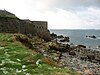 | 49°42′49″N 2°13′56″W[4] | |
| Renonquet | 49°44′0″N 2°17′0″W | ||
| Coque Lihou | 49°41′49″N 2°12′34″W[4] | ||
| Corbet Rock | 49°43′0″N 2°14′0″W[4] | ||
| Fourquie | 49°43′0″N 2°22′0″W[4] | ||
| Houmet Herbé | 49°43′33″N 2°9′29″W[4] | ||
| Le Puits Jervais | 49°42′7″N 2°13′54″W[4] | ||
| L'Equêt | 49°43′0″N 2°21′0″W[4] | ||
| Les Etacs | 49°42′16″N 2°14′23″W[4] | ||
| Les Homeaux Florains | 49°43′52″N 2°9′43″W[4] |
| Name | Image | Coordinates | Area (hectares) |
|---|---|---|---|
| Brecqhou[3] |  | 49°26′0″N 2°23′0″W | 35.2[a][8] |
| Les Burons | 49°25′47″N 2°20′22″W[4] | ||
| Baleine | 49°24′55″N 2°21′42″W[4] | ||
| Moie de Breniere[3] | 49°24′34″N 2°22′6″W[4] | ||
| Moie de Port Gorey | 49°24′26″N 2°22′50″W[4] | ||
| Moie de la Bretagne | 49°24′45″N 2°23′5″W[4] | ||
| Moie de la Fontaine | 49°24′56″N 2°22′58″W[4] | ||
| Tintageu | 49°26′17″N 2°22′15″W[4] | ||
| Les Autelets[9] |  | 49°26′27″N 2°22′9″W[4] | |
| Bec du Nez |  | 49°27′3″N 2°22′9″W[4] | |
| L'Etac[3] |  | 49°24′4″N 2°22′3″W[4] | |
| Moie du Mouton | 49°26′4″N 2°22′26″W[4] | ||
| La Grune | 49°27′0″N 2°22′4″W[4] | ||
| Courbée du Nez | 49°27′2″N 2°22′8″W[4] |
| Name | Image | Coordinates | Area (hectares) |
|---|---|---|---|
| Caquorobert | 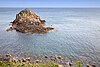 | 49°28′0″N 2°27′0″W | |
| Jethou[3] |  | 49°27′30″N 2°27′45″W | 18[b] |
| Crevichon[3] |  | 49°27′56″N 2°27′53″W | 3.0[a] |
| Grande Fauconnière[3] | 49°27′0″N 2°28′0″W[4] | ||
| Goubinuere | 49°27′0″N 2°27′0″W[4] | ||
| Homet | 49°29′0″N 2°28′0″W[4] | ||
| La Conchée[10] | 49°25′9″N 2°20′24″W[4] | ||
| Godin | 49°29′0″N 2°26′0″W[4] | ||
| Hermetier | | 49°28′0″N 2°27′0″W |
| Name | Image | Coordinates | Area (hectares) |
|---|---|---|---|
| Lihou[3] |  | 49°27′40″N 2°40′3″W | 15[b] |
| Lihoumel | |||
| Houmets | 49°29′43″N 2°29′55″W | ||
| Brehon |  | 49°28′17″N 2°29′18″W | |
| Les Hanois[2] |  | 49°26′0″N 2°42′0″W[4] | |
| La Grosse Rock[11] | 49°26′4″N 2°40′42″W[4] | ||
| Crève Coeur | 49°31′0″N 2°32′0″W[4] | ||
| Cul de l'Autel | 49°30′0″N 2°26′0″W[4] | ||
| La Conchée | 49°28′17″N 2°38′44″W[4] | ||
| La Platte Fougère[12] |  | 49°30′51″N 2°29′7″W |
Uninhabited islands in the Bailiwick of Jersey
[edit]The Bailiwick includes the uninhabited (or nearly uninhabited) islands and islets of:[2]
| Name | Image | Coordinates | Area (hectares) | Notes |
|---|---|---|---|---|
| Minquiers[13] | 48°58′14″N 2°3′43″W | Other islets nearby include Maîtresse Île / Maîtr' Île, Les Maisons, Le Niêsant, Les Faucheurs, La Haute Grune | ||
| Écréhous[14] |  | 49°16′59″N 1°55′59″W | Other islets nearby include Maîtr'Île, La Marmotchiéthe, Lé Bliantch'Île, Les D'mies, La Grand' Naithe, L'Êtchièrviéthe, Lé Fou, La Froutchie | |
| Les Dirouilles[14] | 49°19′59″N 2°4′59″W | |||
| Pierres de Lecq[15] |  | 49°17′31″N 2°12′9″W | Other islets nearby include L'Êtchièrviéthe; La Rocque du Nord; L'Êtaîse or L'Êtaîthe; Lé Bel; Lé Longis; La P'tite Mathe; La Grôsse (Great Rock); La Grand' Mathe; La Greune dé Lé or La Bonnette; La Greune du Seur-Vouêt; L'Orange; La Vouêtaîse, La Vouêtaîthe or La Vouêt'rêsse; La Cappe; La Douoche; Lé Byi; La Rocque Mollet; L'Êtché au Nord-Vouêt; La Galette; La Briarde; La Sprague; La Niêthole Jean Jean or Lé Gouoillot. | |
| Île Agois |  | 49°14′57″N 2°10′55″W | ||
| La Motte |  | 49°9′38″N 2°4′38″W | Tidal island, also known as Green Island. | |
| L'Islet |  | 49°10′30″N 2°7′30″W | Site of Elizabeth Castle. | |
| Île au Guerdain |  | 49°10′11″N 2°10′39″W[4] | Site of Janvrin's Tomb. | |
| Icho | 49°8′54″N 2°2′59″W | Site of Icho Tower. | ||
| L'Avarison |  | 49°9′27″N 2°0′28″W | Site of Seymour Tower. | |
| Île Mâitre | 49°17′0″N 1°55′40″W[4] | |||
| Marmotier | 49°17′30″N 1°55′40″W[4] | |||
| La Sambue | 49°9′17″N 2°4′52″W[4] | |||
| Long Echet |  | 49°15′14″N 2°6′16″W[4] |
Islands in Chausey
[edit]The archipelago of Chausey comprises 365 islands at low tide, compared to only 52 islands at high tide.[16]
| Name | Image | Coordinates | Area (hectares) |
|---|---|---|---|
| Grande-Île | | 48°52′20″N 1°49′50″W | 45 |
| La Genétaie | 48°52′39″N 1°50′31″W | 1.82 | |
| La Meule | 48°52′51″N 1°51′37″W | 1.38 | |
| La Houllée | 48°52′43″N 1°51′12″W | 0.86 | |
| L'îles aux Oiseaux | 48°53′0″N 1°52′0″W | 0.62 | |
| Grand Épail | 48°52′14″N 1°50′25″W | 0.29 |
Notes
[edit]- ^ Jump up to: a b c d e f g h Change in units: quantity in square kilometre has been automatically converted to hectare for uniformity.
- ^ Jump up to: a b Change in units: quantity in acre has been automatically converted to hectare for uniformity.
References
[edit]- ^ http://www.gov.je/Government/JerseyInFigures/Population/Pages/Population.aspx
- ^ Jump up to: a b c Coysh, Victor (1985). Channel Islets. Guernsey: Guernsey Press. ISBN 0902550128.
- ^ Jump up to: a b c d e f g h "Gull Breeding Sites in the Bailiwick of Guernsey". Archived from the original on 4 March 2016. Retrieved 4 November 2015.
- ^ Jump up to: a b c d e f g h i j k l m n o p q r s t u v w x y z aa ab ac ad ae af ag ah ai aj ak al am Geographic Names Server, Wikidata Q1194038
- ^ "Fort Ile de Raz". Visit Alderney. Archived from the original on 18 July 2024. Retrieved 4 November 2015.
- ^ "Region 8. Longis Bay and Essex Hill to Bluestone Bay;". Flora.org.gg. Archived from the original on 18 July 2024. Retrieved 4 November 2015.
- ^ "Fort Clonque". The Landmark Trust. Archived from the original on 18 July 2024. Retrieved 4 November 2015.
- ^ https://www.brecqhou-stamps.co.uk/
- ^ "Les Autelets, Сарк" . Архивировано из оригинала 18 июля 2024 года . Получено 2 мая 2019 года .
- ^ "М.В. Мемориал процветания" . Би -би -си. Архивировано из оригинала 18 июля 2024 года . Получено 23 декабря 2019 года .
- ^ «Освободительный флаг Rocce Rocce Flag» 2009 года » . Би -би -си. Архивировано из оригинала 18 июля 2024 года . Получено 23 декабря 2019 года .
- ^ «Респудный бетонный ремонт» . Архивировано из оригинала 13 октября 2015 года . Получено 4 ноября 2015 года .
- ^ "Минкерс, Джерси " Рамсар.
- ^ Jump up to: а беременный "Les Elées & Les Dirouilles, Джерси" . Рамсар.
- ^ "Камни Лекка " Рамсар.
- ^ Имс, Эндрю (23 мая 2023 г.). «Красивый остров Норманд, о котором вы, вероятно, никогда не слышали» . Ежедневный телеграф . Получено 11 июня 2024 года .