Брандюэлл, остров Мэн

| Брандюэлл, остров Мэн | |
|---|---|
 B10 Beinn-Y-Phott Road смотрит в сторону Брандюэлла, горы Слио Дху и горы Карин. | |
| Координаты | 54 ° 14´53,9 ″ с.ш. 4 ° 32'27,3 ″ со / 54,248306 ° с.ш. 4,540917 ° С |
| Built | 1864-65, 1894-96, 1935, 1938 (road) |
 Location of Brandywell, Isle of Man in Isle of Man | |
Бранивелл, остров Мэн ( Манкс : Чиббедж-Фанч ) [ 1 ] или ( Manx : Chibbyr Slieau Maggle ) [ 2 ] это район горных земель Хит Мурлян [ 3 ] [ 4 ] и хвойные лесные плантации, расположенные в северном массиве нагорья [ 5 ] в приходе Кирка Майкла на острове человека . Ранее район был использован местными пастухами из -за местного потока и близлежащей бывшей почитаемой водной скважины , которая была известна своим отличительным качеством и « бренди » цвета воды. [ 6 ]
Местоположение и описание
[ редактировать ]вересковая это открытая пустоша - Площадь Брандивелла [ 7 ] и Huncerbreck Hill недалеко от частной резиденции « Коттедж Брандюэлл » [ 8 ] КОТТАЖА ПРЕДОСТАВЛЕНИЯ ПРЕДОСТАВЛЕНИЯ ГОРЯННОГО Шепарда. [ 9 ] [ 10 ]
The area of Brandywell includes the secondary B10 Beinn-y-Phott Road, the B25 West Baldwin Road, B10 Brandywell / Sartfell Road with the junction with the B26 Ballaugh Glen (Druidale) Road at ‘Brandywell Cottage.’ The area is dominated by the nearby Snaefell Mountain with an elevation of 621 m (2,037 ft) above sea level and the nearby summits of Beinn-y-Phott 544 metres (1,785 ft), Sartfell 454 metres (1,490 ft), Slieau Maggle 427 metres (1,401 ft) and nearby Injerbreck Hill 399 metres (1,309 ft). The Sulby river has its source here,[11] which flows into the nearby Sulby Reservoir (capacity 4,837 million litres), built in 1983.[12]
Area of Specific Scientific Interest
[edit]The mountain moorland of the Beinn-y-Phot uplands including Brandywell, Injebreck Hill, Slieau Maggle mountain and part of Druidale adjacent to the Sulby reservoir is an Area of Specific Scientific Interest (ASSI) and upland conservation "hot-spot."[13] The area of Brandywell and the adjacent Brandywell junction with A18 Snaefell Mountain Road, the Beinn-y-Phott uplands, Snaefell, Mullagh Ouhr and Clagh Ouhr mountains is the largest continuous area of grassland moorland of 2,654.60 hectares (6,559.7 acres) found on the Isle of Man.[14]
Origin of Name
[edit]The name Brandywell originates from a nearby water-well.[15][16] For the adjacent property of ‘Brandywell Cottage,’ the publication, A Gazetteer of the Isle of Man writes about a local story:
"...a rich Manxman, who had been successful abroad, hired men to work here. To demonstrate his wealth, he filled the local well with Brandy."[17]
Brandywell in the parish of Kirk Michael was also a place where local mountain shepherds would gather to celebrate Forester's Day[18] and to brand and sort flocks of mountain sheep including the castration of male lambs.[19][20]
The Manx name Chibbyr Slieau Maggle or Chibber slew ne Magerell means "the well at the mountain of testicles", referring to the castration of sheep at this location.[21]
Brandywell Corner, A18 Snaefell Mountain Road
[edit]
The Brandywell Corner, previously the 'Mountain Gate,'[22] Iron Gate,[23] or 'Brandywell Gate'[24] is the site of a former parish boundary marker cairn and gates for the Crown Commons land of Beinn-y-Phott mountain. It is located between the 6th Milestone and 7th Milestone road-side markers on the primary A18 Snaefell Mountain Road and with the road junction with the secondary B10 Beinn-y-Phott road or Brandywell Road in the parish of Kirk Lonan with the adjoining boundary-line for the parishes of Kirk Braddan and Christ Kirk Lezayre in the Isle of Man.[25] The Brandywell Road junction with the A18 Snaefell Mountain Road is the site of an Isle of Man TT Marshal communication shelter.[26]
The publication, A Gazetteer of the Isle of Man writes:
"....Brandywell Road ....This name has been adopted by the motor cycle fraternity for the sweeping left hand bend.....where the B10 leaves the TT course (A18) a short distance on from Hailwood Rise. The OS Landranger Map 95 further confuses by marking this place as Brandywell."[27]
A18 Snaefell Mountain Road
[edit]The A18 Snaefell Mountain Road was developed in the mid-nineteenth century from a number of pre-existing roads, carting-tracks and horse-paths.[28] This included installation of a number of sheep-gates including the Beinn-y-Phott sheep-gate near the Brandywell Corner road junction.[29] This section of the A18 Snaefell Mountain Road from the Keppel Gate northwards to (North Barrule) was built following a recommendation in a report to Tynwald made by the Disafforesting Commission of 1860. The A18 road was built on crown commoners grazing land that transferred to the UK Crown following the sale of the Islands feudal rights by John Murray, 4th Duke of Atholl in 1824.[30]
The Brandywell Corner was subject to road widening with the removal of the Beinn-y-Phott sheep-gate on the A18 Mountain Road for the 1935 Isle of Man TT Races.[31]
Via Regia footpath and the Millennium Way
[edit]The footpath at Brandywell Corner is an ancient ridge-way or pathway part of the Via Regia (Royal Way)[32] of the Kings of Mann and now part of the Isle of Man Millennium Way public footpath.[33]
Motor-sport heritage
[edit]The Iron Gate section of A18 Snaefell Mountain Road near to the Brandywell road junction was part of the 52.15 mile Highland Course (revised to 40.38 miles in 1906)[34] used for automobile racing including the 1904 Gordon Bennett Trial and the RAC Tourist Trophy automobile races held between 1905 and 1907. The course was modified again in 1908 as the 37.50 Mile Four Inch Course for the RAC Tourist Trophy automobile races held in the Isle of Man between 1908 and 1922.[35]
In 1911 the Four Inch Course for automobiles was first used by the Auto-Cycling Union for the Isle of Man TT motorcycle races.[36] This included the revised Brandywell Corner and the course later became known as the 37.73 mile Isle of Man TT Mountain Course which has been used since 1911 for the Isle of Man TT Races and from 1923 for the Manx Grand Prix races.[37]
Brandywell Cottage and Brandywell Jumps
[edit]For timed special stages for the Rally Isle of Man and Manx Rally including the former Manx International Rally and Manx Trophy Rally the area of Brandywell and Brandywell Cottage for motor-sport spectators is described as "….a natural amphitheatre."[38] This includes the B10 Brandywell Road/ C37 Druidale double hairpin at Brandywell Cottage, the B22 West Baldwin ‘link road’ and the adjoining ".....famous Brandywell ‘Jumps’......"[39] The B10 Brandywell Road with its junction with the A18 Snaefell Mountain Road at the Brandywell Corner has also been used as part of a special timed stages for the Rally Isle of Man.[40]
Mountain bikes
[edit]The B10 Beinn-y-Phott road section near to the 'Brandywell Cottage'[41] forms the first official manned check-point of Brandywell at 33 kilometres (20.51 mi) for the Isle of Man End-to-End Mountain Bike Challenge.[42][43] The largest single day mountain bike race in Europe, the 75 kilometres (46.60 mi) route races from the Point of Ayre in the north of the Isle of Man to Port Erin in the south of the Island.[44]
The Isle of Man Cyclefest Gran Fondo cycling event[45] consists of an 82.50 miles (132.77 km) figure of eight course. The cross-over point for the northern and southern loops for the Cycling and Mountain Bike section of the cycling race is at Brandywell Cottage.[46] The southern loop of the Gran Frodo event from Baldwin Bridge to Brandywell Cottage contains the 5.4 kilometres (3.36 mi) ‘Injebreck Hill’ climb (average gradient 6%) as featured in the cycling publication "Another 100 Greatest Cycling Climbs."[47]

The Brandywell Corner road junction forms part of two official mountain bike routes. The first A Grand Day Out (cross country loop) a mountain bike trail of 18.5 miles follows the B10 Brandywell Road and the A18 Snaefell Mountain Road and is classified as a Red difficult route.[48] The second official route is the St Luke's & Windy Corner (cross country loop) a mountain bike trail of 17 miles and is also classified as a Red difficult route.[49]
Weather
[edit]There is a small automated Weather Station located to the side of the Isle of Man TT Marshall station at the Brandywell Road Junction, along with a similar weather station at the Mountain Box near to the East Snaefell Mountain Gate. It is currently being used by the Isle of Man Department of Infrastructure and the Brandywell weather station is 425 metres (1,394 ft) above sea level near the highest point of the A18 Snaefell Mountain Road. The automated weather station utilises the TT Marshal's telephone line for digital transmission of weather data and due to the absence of an electricity supply is powered by solar panels and a small wind turbine.[50] In 2005, the Brandywell Junction weather station recorded a wind speed gusts of 97 knots (180 km/h; 112 mph)[51] and in 2017 during the extratropical cyclone of ex-Hurricane Ophelia, recorded a gust of 81 knots (150 km/h; 93 mph).[52]
Gallery
[edit]-
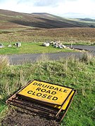 B26 Ballaugh Glen (Druidale) Road at the ‘Brandywell Cottage’ double-hairpin with a north-east aspect towards Slieau Dhoo mountain and Mount Karin.

Sources
[edit]- ^ Place Names of The Isle of Man – Da Ny Manninee Dooie Volume Two. Sheading of Michael: (Kirk Michael, Ballaugh and Jurby) page 55 Kirk Michael by George Broderick – Turbingen ; Niemeyer NE:HST (1995) Manx Place- Name Survey, Max Niemeyer Verlag Tubingen ISBN 3-484-40138-9 (Gesamtwerk) 3-484-40130-3 (Band 2) Druck und Eiband: Weihert-Druck GmbH Darmstadt. "Chibbyr y punch (on Slieau Maggle) AM/C SC38NW SC34728650").
- ^ Place Names of The Isle of Man – Da Ny Manninee Dooie Volume Two. Sheading of Michael: (Kirk Michael, Ballaugh and Jurby) page 55 Kirk Michael by George Broderick – Turbingen ; Niemeyer NE:HST (1995) Manx Place- Name Survey, Max Niemeyer Verlag Tubingen ISBN 3-484-40138-9 (Gesamtwerk) 3-484-40130-3 (Band 2) Druck und Eiband: Weihert-Druck GmbH Darmstadt "Chibber slew ne Magerell LCB 1704. ‘Slieau Maggle well.' "
- ^ Manx Uplands and Steering Group – Issues and Opportunities (1:200,000) page 44, 53–56 & Map page 54 Scale 1:200,000 (April 2014) Isle of Man Department for Environment, Food and Rural Affairs – Rheynn Chymmyltaght, Bee as Eirinys (DEFRA)
- ^ A New History of the Isle of Man Volume 1 – The evolution of the Natural Landscape pages 317, 346 & 391 Edited by Richard Chiverall and Geoffery Thomas(2006) Liverpool University Press ISBN 978-0-85323-577-4
- ^ Manx Uplands and Steering Group – Issues and Opportunities page 4 & map page 13, (Scale 1:200,000) page 43, 53–54 (April 2014) Isle of Man Department for Environment, Food and Rural Affairs – Rheynn Chymmyltaght, Bee as Eirinys (DEFRA) – "Defining the Manx Uplands....all areas of ‘AML’ defined land("Above the mountain line", 250m above sea level), all land above 200m.... all areas of heathland, woodland and water catchment contiguous with the 200m contour."
- ^ Ramsey Courier page 6 Friday 7 October 1960
- ^ Place Names of The Isle of Man – Da Ny Manninee Dooie Volume Two. Sheading of Michael: (Kirk Michael, Ballaugh and Jurby) page 98 Kirk Michael by George Broderick – Turbingen ; Niemeyer NE:HST (1995) Manx Place- Name Survey, Max Niemeyer Verlag Tubingen ISBN 3-484-40138-9 (Gesamtwerk) 3-484-40130-3 (Band 2) Druck und Eiband: Weihert-Druck GmbH Darmstadt. Slieau Maggle ONB1956 SC38NW
- ^ A Gazetteer of the Isle of Man page 61 Leslie Qulliam RBV The Manx Heritage Foundation - Eiraght Ashoonagh Vannin (2005) Quine and Cubbon Ltd ISBN 0 951 4539 12
- ^ Manx Independent – Manninagh Seyr page 23 Thursday 13 October 2016 Isle of Man Newspapers Ltd (2016) Tindle Press Publishing ISSN 1358-4391 Newsprint (Knowsley) Ltd
- ^ Mona’s Herald page 5 Murder in Lonely Farmhouse Wednesday 15 October 1930 "Brandywell Cottage was found to be empty, marks were made so that if anyone enters the cottage the police will be able to tell of the visit. All the searches are armed."
- ^ Andrew Johnson, "The Early Exploitation of the Upper Sulby Valley", Proceedings of the Isle of Man Natural History and Antiquarian Society, 10 (4): 327
- ^ Strategic Business Plan 1999 to 2009 and beyond - Part 1 Executive Summary page 13 4.1 Impounding Reservoirs - Isle of Man Water Authority Lught-Reill Ushtey Ellan Vannin January 1999
- ^ Guidelines for the selection of biological Areas of Special Scientific Interest (ASSIs) on the Isle of Man Volume 2: Detailed habitat and species criteria page 108 The Isle of Man Department of Agriculture, Fisheries and Forestry (2008) (DAFF)
- ^ Isle of Man Ecological Habit Survey Phase 1 1991-1994 final report 1996 4.2.2 Acid grassland page 22 T. Sayle MSc, J. Lamb MSc, A. Colvin BSc, B. Harris BSc Isle of Man Department of Agriculture, Fisheries and Forestry - Rheynn Eirinys, Eeastaght as Keylljyn (DAFF) 1995
- ^ Jenkinson’s Practical Guide to the Isle of Man page 119 by Henry Irwin Jenkinson (1874) Edward Stanford, London.
- ^ Manx Sun page 24 Local News Saturday 22 September 1888 "After toiling up Injebreck Hill, noticing on the way the old well, Slieu Maggie, and wondering who had inhabited the defunct cottage on the brow of the hill...."
- ^ A Gazetteer of the Isle of Man page 61 Leslie Qulliam RBV The Manx Heritage Foundation - Eiraght Ashoonagh Vannin (2005) Quine and Cubbon Ltd ISBN 0 951 4539 12
- ^ Place Names of The Isle of Man – Da Ny Manninee Dooie Volume Two. Sheading of Michael: (Kirk Michael, Ballaugh and Jurby) page 55 Kirk Michael by George Broderick – Turbingen ; Niemeyer NE:HST (1995) Manx Place- Name Survey, Max Niemeyer Verlag Tubingen ISBN 3-484-40138-9 (Gesamtwerk) 3-484-40130-3 (Band 2) Druck und Eiband: Weihert-Druck GmbH Darmstadt. "Chibber y phunch....On the Forester’s Day (?) the shepherds were wont to gather here, and one or two enterprising individuals would dispense hot punch at a remunerative figure....").
- ^ Place Names of The Isle of Man – Da Ny Manninee Dooie Volume Two. Sheading of Michael: (Kirk Michael, Ballaugh and Jurby) page 98 Kirk Michael by George Broderick – Turbingen; Niemeyer NE:HST (1995) Manx Place- Name Survey, Max Niemeyer Verlag Tubingen ISBN 3-484-40138-9 (Gesamtwerk) 3-484-40130-3 (Band 2) Druck und Eiband: Weihert-Druck GmbH Darmstadt. "Slieau Maggle....Here, according to OT sheep were brought for castration..."
- ^ An Illustrated Encyclopaedia of the Isle of Man page 24 by David T. Webber Revised by Frank Cowin and F.J.Radcliffe;- Editor Gordon N. Kniveton (1997) The Manx Experience ISBN 1-873120-25-7 "The mountain road junction by Injebreck Hill, named after a well in the vicinity where shepherds used to gather for the sorting and branding of their mountain sheep."
- ^ George Broderick (2010), "A Grammar of Manx Place-names", The Journal of Scottish Name Studies, 4: 28
- ^ Round the TT Course with Harold Daniell R.R. Holliday Motor Cycling (c1947) Castrol Oils That Lap at 91! Harold L.Daniell, TT Record Holder. Tells How it was done.
- ^ TT Pioneers – Early Car Racing in the Isle of Man page 27 Robert Kelly, Mercury Asset Management (1996) ( 1st Edition) The Manx Experience, The Alden Press ISBN No 1 873120 61 3
- ^ Isle of Man Times page 1 Friday 1 June 1956
- ^ Place Names of the Isle of Man by John J. Kneen MA (1970) Yn Cheshaght Ghailckagh The Scolar Press – page 173-175 and Map Kirk Braddan page 199, page 209-210 and Map Kirk Onchan page 238, pages 241–242 and Map Kirk Lonan page 271 and pages 202–203 Sheading of Garff page
- ^ Isle of Man Examiner page 4 9 September 2008
- ^ A Gazetteer of the Isle of Man page 61 Leslie Qulliam RBV The Manx Heritage Foundation - Eiraght Ashoonagh Vannin (2005) Quine and Cubbon Ltd ISBN 0 951 4539 12
- ^ Isle of Man Examiner page 5 Thursday 5 June 1969
- ^ Isle of Man Examiner page 4 9 December 1925 "MOTOR-CYCLE RELIABILITY RUN - The proposed course is via Anxfell, Laxey....Ramsey, Sulby, Tholty-y-Will, Bungalow and then to Nobles Gate and turn right to Brandywell over Injebreck Mountain...."
- ^ Страницы Manx Mileshones 13–17 и страницы 57–58 Стюарта Слэка (1 -е издание) (2003). ISBN 1-873120-58-3
- ^ Остров человека еженедельно от 25 мая 1935 г.
- ^ Рэмси Курьер Page 6 The Old Manx Roads в пятницу, 6 октября 1961 г.
- ^ Остров Человека поезда, трамвай и под ногами 118 Стэна Баснетта (1990). ISBN 1-899602-72-0 Прогулка 22-тысячелетний путь Древний Ридэйвей Кроника-Кингс Манни и остров.
- ^ TT Pioneers - Ранние автомобильные гонки на острове Мэн Страница 22 Роберт Келли, Mercury Asset Management (1996) (1 -е издание) Опыт Manx, Alden Press ISBN № 1 873120 61 3
- ^ Опыт MANX. Сувенирный гид по острову человека. Страница 66-67 Гордон Н. Книвертон, 8-е издание, Manx Experience (1987) Mannin Publishing Ltd
- ^ Вокруг курса TT с Garold Daniell RR Holliday Motor Cycling (C1947) Кастрольные масла, которые проходят в 91! Гарольд Л.даниэлл, TT Record Holder. Рассказывает, как это было сделано.
- ^ История Гран -при Манса Страница 7, 8, 9 БИЛЛ СНЕЛЛИ АМУЛРИ Издательство (1998) Фонд наследия Manx ISBN 1 901508 04 8
- ^ Европейский чемпионат по ралли для водителей Co -EF 4 Manx International Rally 1986 Официальная программа 10–13 сентября 1986 г. Стр. 15 Manx International Rally Ltd (1986) Ассоциация авторитетных видов спорта RAC - Туристический совет Айла - Print Centrs Ltd, Брэддан.
- ^ Европейский чемпионат по ралли для водителей Co-EF 20 1988 Manx International Rally Официальная программа 13-16 сентября 198 8 Page 16 Manx International Rally Ltd (1988) Ассоциация моторных видов спорта RAC Isle of Man Tourist Board-Print Centrs Ltd, Braddan.
- ^ Общественное уведомление - Manx International Rally 2004 Дороги, закрытые для публичного директора транспорта BW Hannay. Дорога C37 Druidale от его развязки с дорогой Ballaugh Glen до его перекрестка к B10 Brandywell Road в Brandywell Cottage. Брандюэлл -роуд от его перекрестка с дорогой Друидейл до его перекрестка с горной дорогой A18 Snaefell.
- ^ Manx Independent - Manninagh Seyr Page 56, 57 и 64 Cycling Sports - EndToend Четверг, 14 сентября 2017 г.
- ^ Программа 2017 End 2 End Mountain Bike Challenge Что вам нужно знать
- ^ Остров мужского курьера - Эйдер Эллан Ваннин Page 40 2 сентября 2016 г. Isle of Man Newspapers Ltd (2016) Tindle Press Publishing
- ^ http://www.end2end.im [ только URL ]
- ^ Островник мужского экзаменатора - Brialtagh Ellan Vannin Page 33 Final Whistle Isle of Man Newspapers Ltd (2017) Johnson Press Publishing - Sheffield Web 16 мая 2017 г.
- ^ Isle of Man Cyclefest 2017 Intro, стр. 9 и 15 Гэри Томпсон Клерк курса: Isle of Man Cyclefest Ltd (2017).
- ^ Еще 100 величайших велосипедных восхождений: путеводитель по дорожным велосипедистам по британским холмам Страница 167 Саймон Уоррен (2012) Francis Lincoln Ltd ISBN 978-0-7112-3265-5
- ^ Гид на горных велосипедах Isle of Man-8 полных самоуправляемых маршрутов Page 3 Посетите остров Мэн (2014). Чтобы впитать великолепный вид .... Грубое спуск на дорогу составляет часть конца конца 2 и следует с осторожностью. TT курс Курс TT в Брандивелле, вы увидите свою отправную точку всего в полумиле к северу ».
- ^ Гид на горных велосипедах Isle of Man-8 полных самостоятельных маршрутов Page 6 Visit Isle of Man (2014). Ландшафты ..... на T -соединении поверните направо к церкви Святого Луки . Выводит вас на B10.
- ^ Isle of Man Examiner - Brialtagh Ellan Vannin , следящий за погодой, страница 4, понедельник, 9 сентября 2008 года, ..... Горная коробка и маршал -хижины брендвелла/погодные станции принадлежат и поддерживаются точкой ..... " ISSN 1358-4383
- ^ Алан Хисскотт (5 марта 2007 г.), «Когда NWP встретил климатологию: штормы над острова Мэн в январе 2005 года», погода , 62 (3): 74–77, Bibcode : 2007wthr ... 62 ... 74h, doi: doi: doi: doi: doi: doi: doi: doi: doi: doi: doi: doi: doi: doi : doi : doi : 10.1002/WEA.36 ".... Более сильные ветры были зарегистрированы над северной частью острова ... но две дорожные метеорологические станции высокого уровня возле Снаефелла зарегистрированы выше Порывы, 88 кт (101 миль в час) в горной коробке (400 метров AMSL) и 97KT (112 миль в час) в Брандюэлле (425 метров AMSL) ».
- ^ Manx Independent- Manninagh Seyr Page 6 Четверг 19 октября 2017 г. Isle of Man Newspapers Ltd (2017) Tindle Press Publishing Newsprint (Knowley) Ltd ISSN 1358-4391