Агриатс пустыня

| Агриатс пустыня | |
|---|---|
| Désert des Agiatives или Les Agriates ( французский ); Tradei ( корсикан ) | |
 Ландшафт Агриатской пустыни в схеме . | |
 Агриатс пустыня | |
| География | |
| Страна | Корсика , Франция |
| Координаты | 42 ° 42′N 9 ° 10′E / 42,700 ° N 9,167 ° E |
Agrits Desert Golden Agrits ( Dird на французском и агритах в корсикане ) Agrits Ten
География
[ редактировать ]Расположение
[ редактировать ]Агриатская пустыня представляет собой территорию, граничащую на юге горным хребтом, Серра -ди -Тендой, и с всех других сторон у Средиземного моря . Территория разделена с запада на восток, между коммунами Паласки , Сан-Гавино-Ди-Тенда , Санто-Пьетро-Ди-Тенда и Сен-Флорентом . Агриаты в основном необитаемы, за исключением разбросанной деревни Каста .
Некоторые туристические гиды описывают агриалы как единственную пустыню в Западной Европе, [ 1 ] Но это ложь: Испания, в частности, является домом для пустыни Таберны и Барденас Реалов , а в Исландии была холодная пустыня .

Геология и местность
[ редактировать ]Охватывая площадь приблизительно 15 000 гектаров, агагриаты географически разграничены:
- 37 км девственного побережья на севере
- Департамент маршрута 81 и предгорья Серра -ди -Тенды на юг
- Долина Острикони на западе
- Залив Святой Флорант на севере и равнина Неббио на востоке.
Расположенный на предгорьях Серра -ди -Тенды на юг, агриаты простираются на север до моря. Пустыня разделена на две примерно равные части, разделенные рекой Лиску .
Большая часть западного сектора, отмеченная формациями Rhyolite и Tuff , является защищенной территорией. Менее прочный восточный сектор, состоящий из древних гранитных пород, имеет более плоские части, которые до сих пор являются домом для виноградников - в 1800 -х годах агриаты считались хлебной корсикой Корсики. Mt. Genova, на 421 метрах, является его самой высокой точкой. Район является домом для двух дольменов, которые защищены в рамках памятников историей классификации . [ 2 ]
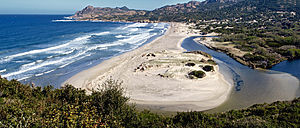
Морская граница Agriates состоит из зазубренной береговой линии с серией накидных и песчаных пляжей. Здесь находится прибрежная тропа, известная как « Сенер» («Путь индивидуальных офицеров»). Руины трех генуэзских башни наблюдения , Мортелла и Форнали башни на востоке и башня Острикони на западе, могут быть найдены вдоль побережья.
Notable sites along the coast, from east to west, are:
- Plage de la Roya (a beach in Saint-Florent)
- the cove of Fornali, its 1762 Paoline tower, and its lighthouse
- Punta Mortella, its Genoese tower (Torra di Mortella), and its lighthouse
- the neighboring islet of La Pignata
- Plage du Loto (a beach shared between the communes of Saint-Florent and Santo-Pietro-di-Tenda)
- Punta di Curza, the northernmost point
- Faghjula Cove and Plage de Saleccia
- Punta di Mignola
- Plage de Trave
- Punta Negra
- Plage de Ghignu
- Punta di Pietra Alta and Plage d'Alga Putrica
- Malfalcu Cove, with its tower base and beach
- Punta di Malfalcu
- Arghiaghiu Cove
- Punta di Solche
- Acciolu Bay, with a beach at the base of Recisa Cove
- Punta di l'Acciolu (Palasca)
- Pinzuta Cove
- Vana Cove
- Punta di Paraghiola
- Peraiola Cove and Plage de l'Ostriconi
There is a marshy area between Plage de Saleccia and Plage du Loto, which includes Padulella, Pardinela, and Cannuta marshes. It contains the ponds of Panecalellu and of Loto.
Many streams flow through the Agriates. From east to west, the major ones are: Valdolèse, Santu, Panecalellu, Niolincu, Liscu, Scalavita, Toccone, Scruchiella, Alga, Tettu, Sualelli, and Tafonatu.
Climate and vegetation
[edit]The Agriates have long been a land of agriculture. The Genoese colonizers made this region the focus of their wheat and olive production. Until the start of the 20th century, figs, citrons, and almonds were also produced there.
Transhumance was also practiced there, and about 100 flocks of sheep or ewes remained at the end of the 19th century.
The Agriates, whose name's etymology refers to agrarian lands, suitable for conservation, are today referred to as a "desert," but the designation is a bit misleading. Unlike the image many hold of a desert, there is abundant local vegetation adapted to the local climate, including such common maquis plants as strawberry trees, briar root, myrtle spurge, rockrose, linstisques, evergreen oak, and olive trees. There are also maritime pines, remnants of 20th-century plantations.
The climate is characterized by very high temperatures during the summer, when dry and hot winds blow across the region. Rainfall is rare, but when it appears it is usually part of a heavy storm.
Access
[edit]Departmental Route 81 crosses the territory from east to west, from Saint-Florent to the Ostriconi Valley, where it rejoins RN 197 at a place called Petra Moneta, passing through the Vezzu pass (Bocca di Vezzu) at 311 meters above sea level. RD 81 marks the southern edge of the Agriates Desert.
In addition to the trail along the coast, several paths provide access to the main sites of the Agriates. From RD 18 there are two main trails headed north. The first, which is 13 km long, starts in Bocca di Vezzu and leads to Malfalcu Cove or to Plage de Ghignu. The second leaves from Casta and travels 12 km to Saleccia and its beach. From RT 30, there is a road that runs about 10 km to Cala di l'Arghiaghiu. There are signs throughout warning visitors of the level of fire risk, which when particularly high can lead to the closure of certain routes.
Sea shuttles provide access to the Loto and Saleccia beaches from Saint-Florent.
Urbanization
[edit]Casta, a village in the Santo-Pietro-di-Tenda commune and the only town in the desert, is located along RD81. Houses and a small number of shops are scattered across a 4 km stretch of the road. In the middle of the village, along the roadside, is the San Pancraziu chapel, which is built from blocks of white granite.
In the mid-20th century, tourist development was planned for a large portion of the western Agriates, owned by the Casabianca and Rothschild families. A 1,000-bed project by the Malfalcu marina was considered, and roads began to be built in the desert. But the Conservatoire du littoral conservation organization patiently bought up all of the territory's coastline, protecting more than 5,600 hectares and 37 km of coasts.
History
[edit]Pre-history
[edit]The site has been occupied since the Neolithic period, as evidenced by archeological expeditions and the dolmens of Mt. Revincu, present in Casta-Nord and classified as monuments historiques since 1889.
Middle Ages
[edit]Bishop Agostino Giustiniani, appointed to the Roman Catholic Diocese of Nebbio, gave the following description of the Agriates in his Dialogo on September 11, 1514:
"After Mortella comes the beach of Cavallata, the little port, Peralto, the point of Corsa, the beach of Saleccia with a stream, the point of Mignola, Trave beach, the point of Giunepreto, Giugno beach, the point of Timoni, the litte Malfalco port, Alga beach, the point of Solche, the calangue of Suppe, the point of Lacciuolo, the calangue of Gueno, and finally Porraggiola beach. From there to Mortella is around 20 miles. This region is called l'Agriata, and it is linked to Nebbio, because the cathedral church of Nebbio and many other parishes in this diocese collect tithes there. On the coast, as in the interior, l'Agriata is a completely inhabited area. There are many fields of wheat or, as the Corsicans say, of prese, cultivated by the people of Nebbio or of Cap Corse. The products of l'Agriata are very delicious; the wheat, the meat, even the fish are the most exquisite in all of Corsica." — Agostino Giustiniani, translated to English from a French translation by the abbot Lucien Auguste Letteron in Histoire de la Corse Tome I, Description de la Corse - Bastia Imprimerie et librairie Ollagnier - 1890 p. 16
In 1584, the island was hit by a famine, and all resources were scarce. Letterton writes, "The sole cause, or at least the main cause, of the famine that reigned during those sad years must be the abandonment of their rich and opulent villages by the inhabitants of the coast, who, in order to flee the attacks of the barbarians, had withdrawn during the earlier wars to the arid and barren mountains. Thus, the village of Agriata and part of Ostricone were abandoned.[3]
For several centuries, the Agriates served as the "breadbasket of Corsica," before returning to their wild state at the end of the 19th century. The Republic of Genoa, which lacked a sufficiently developed hinterland, also farmed in the Agriates to feed its metropolitan population. For a long period the land was used from June to October by farmers who came by sea on small boats from Cap Corse (Nonza, Farinole, Centuri) or from Balagne. They stayed until the harvest and left after the clearing, plowing, and autumn sowing. They then were replaced with sheep herders, who came down from the mountains for the winter. As the farmers left and herders arrived, they would exchange their products: cheese for wheat or oil.
Modern period
[edit]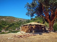
Until the start of the 20th century, wheat, citrus fruits (citrons, lemons, mandarin oranges), olive trees, fig trees, and other crops were cultivated there. However, controlled burns and wildfires overtook the fertile land.
Human habitation has left many traces in the Agriates Desert. For housing, farmers and herders had built pagliaghji, a kind of shack known as palliers in French. Pagliaghju were dry stone huts, with rounded roofs or terraces, which were used as homes, to hold sheep, or to store wheat, hay, or tools. They contained a single room with one door. Though the structures are long abandoned, some are still in good condition, while others have been restored and converted into tourist rentals, including in Alga Putrica, west of Guignu beach.
Present day
[edit]In 1958, the Agriates Desert was considered as a nuclear test site.[4]
In the eastern Agriates lies the Casta firing range, which consists of two zones, separated by the D81 road. It is still operational and is used by soldiers from the 2nd Foreign Parachute Regiment of the French Foreign Legion, based in Calvi. There are two dolmens in the northern part of the shooting range, 700 meters southwest of Mt. Revincu, which are classified as historic monuments.[5]
Economy
[edit]
The region's few shops, hotels, and restaurants are located along the road that passes through Casta. The only restaurant along the entire Agriates coast is in Saleccia.
Viticulture and mixed farming are still the main agricultural activities there. To the north of Casta are two wine estates, each with around 35 hectares of grapevines, located within the perimeter of Corsica's Patrimonio wine region. The region's few farms are reached by a path that starts north of Casta. At least one shepherd has been authorized by the Conservatoire du littoral to operate in the Agriates Desert.
At the spot known as Bartolacciu, there is a small dam built on the Bartolacciu stream (a section of the Fiume Santu).
Landmarks
[edit]Natural heritage
[edit]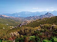
Conservatoire du littoral
[edit]Since 1979, 5,532 hectares of the Agriates Desert, representing 37 kilometers of coastline, have been acquired by the Conservatoire du littoral. Another 5,000 hectares are owned by the communes of Palasca, San-Gavino-di-Tenda, Santo-Pietro-di-Tenda, and Saint-Florent. The remaining third, another 5,000 hectares or so, is private property. The area is protected under Inventaire national du patrimoine naturel code FR1100014 - Agriate.[6]
Today, the Conservatoire controls a third of the land and the marine area, serving as a long-term guarantor of the natural landscape.
After a consultation, the Conservatoire and the departmental council have put together a territorial project and a development plan that is financially supported by the Office de l'environnement de la Corse. The department of Haute-Corse is responsible for the management of the region, which includes surveillance, maintenance, public access, and development.
Since 2008, eight departmental coast guard officers have been responsible for managing the territory. One of these agents handles overnight visitors to the beach at Ghignu in the summer.[7] Their responsibilities are numerous, including maintaining and cleaning beaches and trails. In the summer, they contribue to the desert's fire prevention system, warning visitors when the Saleccia trail is closed on high-risk days. They are also given the power of law enforcement officers and can issue a procès-verbal, enabling them to combat illegal camping, fires, and off-road driving. The officers traverse the region by foot, on horseback, in four-wheel-drive vehicles, and by boat.
There is a guard house in Saleccia, consisting of an old pagliaghju restored by the Conservatoire.
ZNIEFF
[edit]There are three sites recognized as second-generation Zone naturelle d'intérêt écologique, faunistique et floristique (ZNIEFF) in the Agriates Desert:
- Ostriconi dunes, beach, and wetland
- The area covers 373 hectares, surrounding the mouth of the Ostriconi River, and is primarily composed of a large beach with sparse vegetation, a vast stretch of dunes, and sandy terraces. It is registered as ZNIEFF 940004143.[8]
- Aleppo pine woods of Punta di Curza
- This natural area of ecological, faunistic, and floristic interest covers 150 hectares on the coast of the Agriates. It is made up of juniper dunes and wooded pine dunes (Saleccia) that are 4 to 5 meters high, with a matorral shrub landscape made up of wild olive trees and rockrose. It is protected under ZNIEFF 940004072.[9]
- Mouths of the Santu River and the Valdolese
Natura 2000
[edit]Регион обозначен как часть сети в Европе Natura 2000 , зарегистрированной как FR9400570. [ 11 ]

Архитектурное наследие
[ редактировать ]- Мортелла башня
- Эта башня была построена в 1553 году и укреплена в 1554 году, во время корсиканской войны адмиралом Адреа Дорией . Это единственная башня вдоль побережья Агриатса, которая оставалась в течение 17 и 18 веков и до сегодняшнего дня. Это зарегистрированный исторический памятник.
- Остриконы башня
- Эта башня, также известная как Fornali, Parajola или Vana Tower, представляет собой прямоугольную генузкую башню (6 на 7 метров), которая находится на севере руин журнала I и пляжа Острикони, с видом на Пунта -ди Парагиолу. Эта генуэзская башня была частью системы защиты для агриатов и святого флорента, построенной генуэзцами в 16-м веке.
- Другие башни
- В общей сложности было планировалось построить дюжину башен, которые будут построены вдоль побережья Агриатского побережья и залива Сен-Флорент от Пунта-ди-Парагиолы на западе до Каланты ди-Торре под Пунта-Веккией на востоке. В то время как некоторые из башен были полностью построены, для других была построена только база.
Ссылки
[ редактировать ]- ^ "Агриальные, камни и макис смотрят на море " Корсиканская баллага (на французском языке ) Получено 2021-01-1
- ^ «INPN, Znieff 940004071 - Desert des Agriate - Описание» . Национальный инвентарь природного наследия (на французском языке) . Получено 2021-01-12 .
- ^ Спросите Litteron в Histerose de la Corse Tomi , Chizina Filippini - Bastia Picture Bastia Images - 1890 с. 343
- ^ Комиссия по истории ядерного вооружения (Париж) (2000). Наука, технология и защита: стратегии вокруг атома и космоса, 1945-1998 . Лист Grou-Radenez). Винсенн: Центр исследований истории обороны. ISBN 2-9515024-0-0 Полем OCLC 470432935 .
- ^ "Долмен из горы-Ривико " Французское министерство культуры Получено 2021-01-1
- ^ "FR1100014 - Агриат" . INPN (по -французски) . Получено 2021-01-24 .
- ^ Бюллетень консерватории и девять Quii de Neuf? - десятилетия 2009 года
- ^ «Zieft 940004143 - Дюны, Plage et Области Humide de the Oyricons » . INPN (по -французски) . Получено 2021-01-24 .
- ^ «Znieff 94004072 - Bois of Pint Aleep of of и» . INPN (по -французски) . Получено 2021-01-24 .
- ^ "Zieff 2740004074 - Emanbouchures du Fium'santo et du Valdolese" . INPN (по -французски) . Получено 2021-01-24 .
- ^ «FSD Natura 2000 - FR9400570 - Agriates» . INPN (по -французски) . Получено 2021-01-24 .