Arrondissement of Saint-Dié-des-Vosges

Saint-Dié-des-Vosges | |
|---|---|
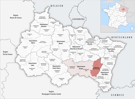 Location within the region Grand Est | |
| Country | France |
| Region | Grand Est |
| Department | Vosges |
| No. of communes | 96 |
| Subprefecture | Saint-Dié-des-Vosges |
| Area | 1,458.2 km2 (563.0 sq mi) |
| Population (2021)[1] | 108,248 |
| • Density | 74/km2 (190/sq mi) |
| INSEE code | 883 |
| Part of a series on |
| Lorraine |
|---|
 |
The arrondissement of Saint-Dié-des-Vosges is an arrondissement of France in the Vosges department in the Grand Est région. It has 96 communes.[2] Its population is 111,750 (2016), and its area is 1,458.2 km2 (563.0 sq mi).[3]
Composition
[edit]The communes of the arrondissement of Saint-Dié-des-Vosges, and their INSEE codes, are:[2]
- Allarmont (88005)
- Anould (88009)
- Arrentès-de-Corcieux (88014)
- Ban-de-Laveline (88032)
- Ban-de-Sapt (88033)
- Ban-sur-Meurthe-Clefcy (88106)
- Barbey-Seroux (88035)
- Basse-sur-le-Rupt (88037)
- Belval (88053)
- Bertrimoutier (88054)
- Le Beulay (88057)
- Biffontaine (88059)
- Bois-de-Champ (88064)
- La Bourgonce (88068)
- La Bresse (88075)
- Celles-sur-Plaine (88082)
- Champdray (88085)
- La Chapelle-devant-Bruyères (88089)
- Châtas (88093)
- Cleurie (88109)
- Coinches (88111)
- Combrimont (88113)
- Corcieux (88115)
- Cornimont (88116)
- La Croix-aux-Mines (88120)
- Denipaire (88128)
- Entre-deux-Eaux (88159)
- Étival-Clairefontaine (88165)
- La Forge (88177)
- Fraize (88181)
- Frapelle (88182)
- Gemaingoutte (88193)
- Gérardmer (88196)
- Gerbamont (88197)
- Gerbépal (88198)
- La Grande-Fosse (88213)
- Grandrupt (88215)
- Granges-Aumontzey (88218)
- La Houssière (88244)
- Hurbache (88245)
- Lesseux (88268)
- Liézey (88269)
- Lubine (88275)
- Lusse (88276)
- Luvigny (88277)
- Mandray (88284)
- Ménil-de-Senones (88300)
- Le Mont (88306)
- Mortagne (88315)
- Moussey (88317)
- Moyenmoutier (88319)
- Nayemont-les-Fosses (88320)
- Neuvillers-sur-Fave (88326)
- Nompatelize (88328)
- Pair-et-Grandrupt (88341)
- La Petite-Fosse (88345)
- La Petite-Raon (88346)
- Plainfaing (88349)
- Les Poulières (88356)
- Provenchères-et-Colroy (88361)
- Le Puid (88362)
- Raon-l'Étape (88372)
- Raon-sur-Plaine (88373)
- Raves (88375)
- Rehaupal (88380)
- Remomeix (88386)
- Rochesson (88391)
- Les Rouges-Eaux (88398)
- Saint-Dié-des-Vosges (88413)
- Sainte-Marguerite (88424)
- Saint-Jean-d'Ormont (88419)
- Saint-Léonard (88423)
- Saint-Michel-sur-Meurthe (88428)
- Saint-Remy (88435)
- Saint-Stail (88436)
- La Salle (88438)
- Sapois (88442)
- Le Saulcy (88444)
- Saulcy-sur-Meurthe (88445)
- Saulxures-sur-Moselotte (88447)
- Senones (88451)
- Le Syndicat (88462)
- Taintrux (88463)
- Tendon (88464)
- Thiéfosse (88467)
- Le Tholy (88470)
- Vagney (88486)
- Le Valtin (88492)
- Ventron (88500)
- Le Vermont (88501)
- Vexaincourt (88503)
- Vienville (88505)
- Vieux-Moulin (88506)
- La Voivre (88519)
- Wisembach (88526)
- Xonrupt-Longemer (88531)
History
[edit]The arrondissement of Saint-Dié-des-Vosges was created in 1800.[4] At the January 2019 reorganisation of the arrondissements of Vosges, it lost seven communes to and gained 15 communes from the arrondissement of Épinal.[5]
As a result of the reorganisation of the cantons of France which came into effect in 2015, the borders of the cantons are no longer related to the borders of the arrondissements. The cantons of the arrondissement of Saint-Dié-des-Vosges were, as of January 2015:[6]
- Brouvelieures
- Corcieux
- Fraize
- Gérardmer
- Provenchères-sur-Fave
- Raon-l'Étape
- Saint-Dié-des-Vosges-Est
- Saint-Dié-des-Vosges-Ouest
- Senones
References
[edit]- ^ "Téléchargement du fichier d'ensemble des populations légales en 2021" (in French). The National Institute of Statistics and Economic Studies. 28 December 2023.
- ^ Jump up to: a b "Arrondissement de Saint-Dié-des-Vosges (883)". INSEE. Retrieved 2019-10-04.
- ^ "Comparateur de territoire, géographie au 01/01/2019". INSEE. Retrieved 2019-10-04.
- ^ Historique des Vosges
- ^ "Arrêté préfectoral, 24 October 2018" (PDF). Retrieved 2019-10-28.
- ^ Populations légales 2012: 88 Vosges, INSEE