Эхинады

Эхинады ( / ɪ ˈ k ɪ n ə d iː z / ; греческий : αἱ per gerodotus , thucydides и strabo , homer echinae ( αἱ , итальянский νῆσοι νῆσοι ἐχινάδες ἐχῖναι per у побережья Акарнании , Греция Архипелаг обычно подразделяется на три группы: Драконеры на севере, Модиа в середине и униады на юге . Oxeia , одна из крупнейших, принадлежит шейху Хамад бен Халифа аль-Тани , эмир Катар , который приобрел их за 7,3 миллиона фунтов стерлингов. [ 1 ] Битва за Эхинады в 1427 году и битва при Лепанто в 1571 году боролись на островах или рядом с ним.
История
[ редактировать ]Several of the islands have been joined to the mainland by alluvial deposits. Herodotus says that half of the islands had been already united to the mainland in his time (ii. 10); and Thucydides expected that this would be the case with all of them before long, since they lay so close together as to be easily connected by the alluvium brought down by the Achelous River (ii. 102.). This expectation, however, has not been fulfilled, which Pausanias attributed (viii. 24. § 11) to the Achelous bringing down less alluvium in consequence of the uncultivated condition of Aetolia; but there can be little doubt that it is owing to the increasing depth of the sea, which prevents any perceptible progress being made.[citation needed]
The Echinades are mentioned by Homer, who, in the Iliad, says that Meges, son of Phyleus, led 40 ships to Troy from Dulichium and the sacred islands Echinae, which are situated beyond the sea, opposite Elis.[2] Phyleus was the son of Augeas, king of the Epeians in Elis, who emigrated to Dulichium because he had incurred his father's anger. In the Odyssey, Dulichium (which may be an island in the Echniades) is frequently mentioned along with Same (Kefalonia), Zacynthus, and Ithaca as one of the islands subject to Ulysses, and is celebrated for its fertility.[3] Strabo, and most modern writers, place Dulichium among the Echinades, most identifying it with the island of Makri. Euripides (in Iphigeneia at Aulis) identifies the Echinades with the islands of Taphos (Taphiae Insulae). However, most modern scholars, including the editors of the Barrington Atlas of the Greek and Roman World, place the island of Taphos at Meganisi east of Lefkada, quite northwest of the Echinades; hence, the islands of Taphos would include Meganisi, Kalamos, Kastos, and surrounding islands.
Homer, as we have already seen, describes the Echinades as inhabited; but both Thucydides and Scylax represent them as deserted.[4] Strabo simply says that they were barren and rugged (x. p. 458). Stephanus of Byzantium names a town Apollonia situated in one of the islands (s. v. Ἀπολλωνία). Pliny the Elder gives us the names of nine of these islands — Aegialia, Cotonis, Thyatira, Geoaris, Dionysia, Cyrnus, Chalcis, Pinara, Mystus.[5] Another of the Echinades was Artemita (Ἀρτεμίτα), which became united to the mainland.[6] Artemidorus spoke of Artemita as a peninsula near the mouth of the Achelous, and Rhianus connected it with the Oxeiae (Oxeias, Oxiés, or Scrofés) islands. (Steph. B. s. v. Ἀπτεμίτα) The Oxeiae (αἱ Ὀξεῖαι) are sometimes spoken of as a separate group of islands to the west or south of the Echinades,[7] but are included by Strabo under the general name of Echinades (x. p. 458). The Oxeiae, according to Strabo, are mentioned by Homer under the synonymous name of Thoae or Thoai.[8]
Name
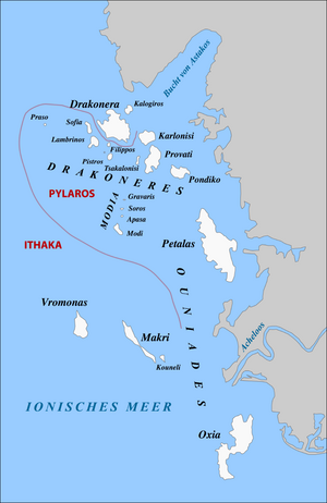
[edit]The Echinades derived their name from the echinus or the sea urchin, in consequence of their sharp and prickly outlines. For the same reason they were called Oxeiae, or the Sharp Islands, a name which one of them still retains under the slightly altered form of Oxeia (Oxiés, Oxiá, or Oxia). Leake remarks that the Echinades are divided into two clusters, besides Petalas (Petalá), which, being, quite barren and close to the mainland, is not claimed, or at least is not occupied by the Ithacans, though anciently it was undoubtedly one of the Echinades. The northern cluster is commonly called the Drakoneres, from Drakonera, the principal island; and the southern, the Ouniades or Oxeiae. By the Venetians they were known as the islands of Kurtzolári, which name belongs properly to a peninsula to the left of the mouth of the Achelous, near Oxeia. Seventeen of the islands have names, besides the four Modia (Stamodio or Módi Islands), two of which are mere rocks, and nine of the seventeen are cultivated. These are, beginning from the south — Oxeia (Oxiá), Makri (Makrí), Vrómonas (Vromotas or Vrómona), Pontikos (Pondikónisi), Karlonísi (Karlónísi), Prováti, Lampriní (Lambrinó), Sofía (Sofiá), also known as Gaia, Drakonera (Dhragonára). Oxeia alone is lofty (421 meters). Makri and Vrómonas are the two islands next in importance.[9]
References
[edit]- ^ "Emir of Qatar buys six Greek islands for £7m". The Telegraph (UK). 5 March 2013. Retrieved 6 March 2013.
- ^ Homer Iliad ii. 625.
- ^ Homer Odyssey i. 245, ix. 24, xiv. 397, xvi. 123, 247; Hymn. in Apoll. 429; Πολύπυρον, Od. xiv. 335, xvi. 396, xix. 292.
- ^ Thuc. ii. 102; Scylax, p. 14.
- ^ iv. 12. s. 19.
- ^ Strabo i. p. 59; Pliny iv. 1. s. 2.
- ^ comp. Pliny iv. 12. s. 19.
- ^ (Θοαί, Odyssey xv. 299.
- ^ Kruse, Hellas, vol. ii. pt. ii. p. 455, seq.; Leake, Northern Greece, vol. iii. pp. 30, seq., 50, seq.; Mure, Tour in Greece, vol. i. p. 104.
- ^ Arnold, Charles. Die Inseln des Mittelmeers. (German.)
- ^ Data from GTP.
- ^ Jump up to: a b c d Προσδιορισμός και χαρτογράφηση των ορνιθολογικά ευαίσθητων στα αιολικά πάρκα περιοχών της Ελλάδας, Ελληνική Ορνιθολογική Εταιρεία (Griechische Ornithologische Gesellschaft) PDF Online[permanent dead link] (1,883 MB), griechisch
 This article incorporates text from a publication now in the public domain: Smith, William, ed. (1854–1857). Dictionary of Greek and Roman Geography. London: John Murray.
 {{cite encyclopedia}}: Missing or empty|title=(help)- Richard Talbert, Barrington Atlas of the Greek and Roman World, (ISBN 0-691-03169-X), p. 54.
External links
[edit]- Official website of Municipality of Ithaca (in English and Greek)
- Island of Petalas for sale
- Another island for sale