Гора Голгофы, Висконсин

Гора Голгофы, Висконсин | |
|---|---|
 Расположение Горы Голгофы в округе Фонд дю Лак, штат Висконсин. | |
| Координаты: 43 ° 49′32 ″ N 88 ° 14′53 ″ W / 43,82556 ° N 88,24806 ° W | |
| Страна | |
| Состояние | |
| Графство | Озеро дно |
| Область | |
| • Общий | 1,06 кв. Миль (2,74 км 2 ) |
| • Земля | 1,06 кв. Миль (2,74 км 2 ) |
| • Вода | 0,00 кв. МИ (0,00 км 2 ) |
| Elevation | 958 футов (292 м) |
| Population | |
| • Total | 548 |
| • Density | 518.9/sq mi (200.4/km2) |
| Time zone | UTC-6 (Central (CST)) |
| • Summer (DST) | UTC-5 (CDT) |
| ZIP Code | 53057 |
| Area code | 920 |
| FIPS code | 55-54650[4] |
| GNIS feature ID | 1569802[2] |

Гора Голголь - деревня в округе Фонд дю Лак , штат Висконсин , США . Население было 548 в переписи 2020 года, по сравнению с 762 в переписи 2010 года.
История
[ редактировать ]Расположение Маунт Голгофы было выбрано миссионерским Каспера Рерл; Он выбрал большой холм из -за его отличного вида, и он положил деревянный крест . [ 5 ] Начиная с 1846 года, поселенцы начали строить дома у подножия холма. [ 6 ] Риль занимал первую массовую массовую общину около 1849 года в доме Джона Дитцена. [ 7 ] Епископ Джон Хенни подтвердил первого ребенка из горы Голгофы в Святой Иоанн Крестительской церкви в соседнем Джонсбурге (это была единственная церковь в регионе). [ 7 ] Приход был основан на Горе Голгофь Рерлом 2 февраля 1849 года; Строительство церкви началось на следующий день. [ 8 ] Церковь была создана школой, и в ней было пять или шесть учеников. [ 9 ]
The community's first general store was built in 1851–1852.[10] Two priests arrived on October 15, 1856, to establish a monastery (it later became the St. Lawrence Seminary High School).[11] A post office was built in November 1877; Anthony Rothgery was named first postmaster.[12] A railroad was established in the 1850s and 1860s; it connected Sheboygan to Fond du Lac.[12] Trains ran twice daily through nearby Calvary Station.[12]
Geography
[edit]Mount Calvary is located at 43°49′32″N 88°14′53″W / 43.82556°N 88.24806°W (43.825664, -88.248114).[13]
According to the United States Census Bureau, the village has a total area of 1.05 square miles (2.72 km2), all of it land.[14]
Mount Calvary is located in an eastern Fond du Lac County, Wisconsin area known as "The Holyland", so-called because of the large number of communities built around churches, including St. Peter, St. Cloud, St. Anna, Marytown, Johnsburg, Calvary, Brothertown and Jericho.
Demographics
[edit]| Census | Pop. | Note | %± |
|---|---|---|---|
| 1970 | 942 | — | |
| 1980 | 585 | −37.9% | |
| 1990 | 558 | −4.6% | |
| 2000 | 956 | 71.3% | |
| 2010 | 762 | −20.3% | |
| 2020 | 548 | −28.1% | |
| U.S. Decennial Census[15] | |||
2020
[edit]As of the census[4] of 2020, there were 548 people, and 259 households in the village. The population density was 517.0 inhabitants per square mile (199.6/km2). There were 218 housing units at an average density of 205.7 per square mile (79.4/km2). The racial makeup of the village was 96.9% White, 0.2% Black or African American, 0.2% Native American, 0.2% Asian, 0.2% from other races, and 2.4% from two or more races. Hispanic or Latino of any race were 1.5% of the population.
2010 census
[edit]As of the census[4] of 2010, there were 762 people, 201 households, and 151 families living in the village. The population density was 725.7 inhabitants per square mile (280.2/km2). There were 215 housing units at an average density of 204.8 per square mile (79.1/km2). The racial makeup of the village was 83.6% White, 1.3% African American, 1.0% Native American, 8.3% Asian, 5.2% from other races, and 0.5% from two or more races. Hispanic or Latino of any race were 10.9% of the population.
There were 201 households, of which 32.8% had children under the age of 18 living with them, 66.2% were married couples living together, 6.0% had a female householder with no husband present, 3.0% had a male householder with no wife present, and 24.9% were non-families. 21.9% of all households were made up of individuals, and 8% had someone living alone who was 65 years of age or older. The average household size was 2.59 and the average family size was 3.01.
The median age in the village was 26.8 years. 39.6% of residents were under the age of 18; 8.2% were between the ages of 18 and 24; 19.4% were from 25 to 44; 16.6% were from 45 to 64; and 16.1% were 65 years of age or older. The gender makeup of the village was 63.5% male and 36.5% female.
2000 census
[edit]As of the census[4] of 2000, there were 956 people, 199 households, and 141 families living in the village. The population density was 902.0 people per square mile (348.2/km2). There were 206 housing units at an average density of 194.4 per square mile (75.0/km2). The racial makeup of the village was 84.21% White, 0.42% African American, 0.52% Native American, 6.69% Asian, 7.74% from other races, and 0.42% from two or more races. Hispanic or Latino of any race were 8.37% of the population.
There were 199 households, out of which 36.7% had children under the age of 18 living with them, 62.3% were married couples living together, 6.5% had a female householder with no husband present, and 29.1% were non-families. 25.1% of all households were made up of individuals, and 12.6% had someone living alone who was 65 years of age or older. The average household size was 2.50 and the average family size was 2.99.
In the village, the population was spread out, with 33.6% under the age of 18, 7.5% from 18 to 24, 16.0% from 25 to 44, 16.9% from 45 to 64, and 25.9% who were 65 years of age or older. The median age was 38 years. For every 100 females, there were 149.0 males. For every 100 females age 18 and over, there were 93.0 males.
The median income for a household in the village was $50,104, and the median income for a family was $53,333. Males had a median income of $42,031 versus $23,462 for females. The per capita income for the village was $13,631. About 4.8% of families and 35.6% of the population were below the poverty line, including 9.2% of those under age 18 and 45.2% of those age 65 or over.
Education
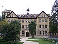
[edit]Mount Calvary is in the New Holstein Public School District. It is also served by the Consolidated Parochial Elementary School (C.P.E.S.) system, run jointly by several local Catholic parishes including St. Isidore (which includes Holy Cross Church in Mt. Calvary), St. John's in Johnsburg, and St. Mary's in Marytown. Recently, C.P.E.S. lost its Mount Calvary location, but is still supported by Holy Cross Church in Mount Calvary. It is also home to St. Lawrence Seminary High School, a Catholic preparatory high school.
Saint Paul's Lutheran School is a grade school (Pre-K-8) of the Wisconsin Evangelical Lutheran Synod near Mount Calvary (in the Town of Forest).[16]
Notable people
[edit]- Heinie Beau – American jazz composer
- Viola Smith – swing band drummer
Images
[edit]-
 Post office
 -
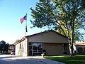
 Fire station
 -
-
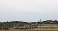 Panorama


Further reading
[edit]- Vieracker, Fr. Corbinian (1907). The History of Mount Calvary, A Commermorative Volume of the Golden Jubilee of the Establishment of the First Friary in North America (translated from German by Ron Jansch in June 2007). Fond du Lac, Wisconsin: Action Printing.
References
[edit]- ^ "2020 U.S. Gazetteer Files". United States Census Bureau. Retrieved March 22, 2024.
- ^ Jump up to: a b "US Board on Geographic Names". United States Geological Survey. October 25, 2007. Retrieved January 31, 2008.
- ^ "Profile of General Population and Housing Characteristics: 2020 Demographic Profile Data (DP-1): Mount Calvary village, Wisconsin". United States Census Bureau. Retrieved March 22, 2024.
- ^ Jump up to: a b c d "U.S. Census website". United States Census Bureau. Retrieved July 9, 2024.
- ^ Vieracker, Fr. Corbinian (1907). The History of Mount Calvary. Fond du Lac, Wisconsin: Action Publishing. p. 20.
- ^ Vieracker, page 22
- ^ Jump up to: a b Vieracker, page 23
- ^ Vieracker, page 26
- ^ Vieracker, page 27
- ^ Vieracker, pages 53
- ^ Vieracker, страницы 44-45
- ^ Подпрыгнуть до: а беременный в Vieracker, страницы 117
- ^ «Файлы американских газетов: 2010, 2000 и 1990» . Бюро переписи Соединенных Штатов . 12 февраля 2011 г. Получено 23 апреля 2011 года .
- ^ "US Gazetteer Files 2010" . Бюро переписи Соединенных Штатов . Архивировано из оригинала 2 июля 2012 года . Получено 18 ноября 2012 года .
- ^ «Перепись населения и жилья» . Перепись.gov . Получено 4 июня 2015 года .
- ^ «Лютеранская школа Святого Павла» . Архивировано из оригинала 14 декабря 2018 года.
Муниципалитеты и общины Фонд дю Лак, штат Висконсин , США. | ||
|---|---|---|
| Города |  | |
| Деревни | ||
| Города | ||
| CDPS | ||
| Другой сообщества |
| |
| Бывший сообщества | ||
| Сноски | ‡ Это население также имеет части в соседнем округе или округах | |
| Базы данных управления авторитетом : географический |
|---|