Округ Чаффи, штат Колорадо

Округ Чаффи | |
|---|---|
| Графство Чаффи | |
 Старый здание суда округа Чаффи | |
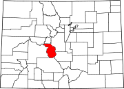
 Interactive map of Chaffee County | |
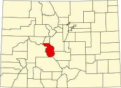 Location within the U.S. state of Colorado | |
| Country | |
| State | |
| Established | February 10, 1879 |
| Named for | Jerome B. Chaffee |
| County seat | Salida |
| Largest city | Salida |
| Area | |
| • Total | 1,015 sq mi (2,630 km2) |
| • Land | 1,013 sq mi (2,620 km2) |
| • Water | 1.6 sq mi (4 km2) 0.2% |
| Highest elevation | 14,421 ft (4,396 m) |
| Population (2020) | |
| • Total | 19,476[2] |
| • Density | 19/sq mi (7/km2) |
| Time zone | UTC−7 (Mountain) |
| • Summer (DST) | UTC−6 (MDT) |
| Area code | 970 719 |
| FIPS code | 08015 |
| GNIS feature ID | 198123 |
| Website | www.chaffeecounty.org |

Округ Чаффи - это округ, расположенный в США штата Колорадо . По состоянию на переписи 2020 года население было 19 476. [ 2 ] Корт округа - Салида . [ 3 ]
История
[ редактировать ]Округ Чаффи имеет запутанное происхождение. В период с 8 по 10 февраля 1879 года округ Карбонат был создан законодательным органом Колорадо из округа Северный Лейк . 10 февраля два округа были переименованы в южную часть округа Лейк -округ, а округ Карбонат стал округом Лейк. Округ Чаффи известен как «Сердце Скалистых гор». Он был назван в честь Джерома Б. Чаффи , [ 4 ] Первый сенатор США в Колорадо.
География
[ редактировать ]According to the U.S. Census Bureau, the county has a total area of 1,015 square miles (2,630 km2), of which 1,013 square miles (2,620 km2) is land and 1.6 square miles (4.1 km2) (0.2%) is water.[5]
Adjacent counties
[edit]- Lake County - north
- Park County - northeast
- Fremont County - southeast
- Saguache County - south
- Gunnison County - west
- Pitkin County - northwest
Major highways
[edit]National protected areas
[edit]- Browns Canyon National Monument
- Buffalo Peaks Wilderness
- Collegiate Peaks Wilderness
- San Isabel National Forest
Recreation area
[edit]Trails
[edit]Bicycle routes
[edit]Demographics
[edit]| Census | Pop. | Note | %± |
|---|---|---|---|
| 1880 | 6,512 | — | |
| 1890 | 6,612 | 1.5% | |
| 1900 | 7,085 | 7.2% | |
| 1910 | 7,622 | 7.6% | |
| 1920 | 7,753 | 1.7% | |
| 1930 | 8,126 | 4.8% | |
| 1940 | 8,109 | −0.2% | |
| 1950 | 7,168 | −11.6% | |
| 1960 | 8,298 | 15.8% | |
| 1970 | 10,162 | 22.5% | |
| 1980 | 13,227 | 30.2% | |
| 1990 | 12,684 | −4.1% | |
| 2000 | 16,242 | 28.1% | |
| 2010 | 17,809 | 9.6% | |
| 2020 | 19,476 | 9.4% | |
| 2023 (est.) | 20,617 | [6] | 5.9% |
| U.S. Decennial Census[7] 1790-1960[8] 1900-1990[9] 1990-2000[10] 2010-2020[2] | |||
At the 2000 census there were 16,242 people, 6,584 households, and 4,365 families living in the county. The population density was 16 people per square mile (6.2 people/km2). There were 8,392 housing units at an average density of 8 per square mile (3.1/km2). The racial makeup of the county was 90.94% White, 1.58% Black or African American, 1.09% Native American, 0.44% Asian, 0.05% Pacific Islander, 4.21% from other races, and 1.69% from two or more races. 8.58% of the population were Hispanic or Latino of any race.[11] Of the 6,584 households 25.20% had children under the age of 18 living with them, 56.70% were married couples living together, 6.80% had a female householder with no husband present, and 33.70% were non-families. 28.40% of households were one person and 11.20% were one person aged 65 or older. The average household size was 2.26 and the average family size was 2.77.
The age distribution was 19.70% under the age of 18, 7.70% from 18 to 24, 28.00% from 25 to 44, 27.50% from 45 to 64, and 17.00% 65 or older. The median age was 42 years. For every 100 females, there were 113.60 males. For every 100 females age 18 and over, there were 116.20 males.
The median household income was $34,368 and the median family income was $42,043. Males had a median income of $30,770 versus $22,219 for females. The per capita income for the county was $19,430. About 7.40% of families and 11.70% of the population were below the poverty line, including 17.30% of those under age 18 and 10.20% of those age 65 or over.
Chaffee County is also home to a source of water that Arrowhead water uses for some water bottles. The source is Ruby Mountain Springs.
Politics
[edit]Chaffee County is a bellwether county, having supported the winner of 8 out of the last 11 presidential elections. The most recent election where Chaffee County supported the presidential loser was in 2008, when John McCain narrowly won the county despite Barack Obama winning decisively nationally and statewide.
| Year | Republican | Democratic | Third party(ies) | |||
|---|---|---|---|---|---|---|
| No. | % | No. | % | No. | % | |
| 2020 | 6,222 | 45.36% | 7,160 | 52.19% | 336 | 2.45% |
| 2016 | 5,391 | 47.92% | 4,888 | 43.45% | 971 | 8.63% |
| 2012 | 5,070 | 48.46% | 5,086 | 48.61% | 306 | 2.92% |
| 2008 | 4,873 | 49.12% | 4,862 | 49.01% | 186 | 1.87% |
| 2004 | 4,875 | 55.59% | 3,766 | 42.94% | 129 | 1.47% |
| 2000 | 4,300 | 56.50% | 2,768 | 36.37% | 542 | 7.12% |
| 1996 | 3,052 | 46.85% | 2,768 | 42.49% | 695 | 10.67% |
| 1992 | 2,419 | 38.51% | 2,284 | 36.36% | 1,579 | 25.14% |
| 1988 | 3,080 | 53.90% | 2,548 | 44.59% | 86 | 1.51% |
| 1984 | 3,680 | 66.31% | 1,779 | 32.05% | 91 | 1.64% |
| 1980 | 3,327 | 60.73% | 1,583 | 28.90% | 568 | 10.37% |
| 1976 | 2,925 | 56.66% | 2,064 | 39.98% | 173 | 3.35% |
| 1972 | 2,859 | 66.63% | 1,354 | 31.55% | 78 | 1.82% |
| 1968 | 2,121 | 51.07% | 1,667 | 40.14% | 365 | 8.79% |
| 1964 | 1,476 | 37.36% | 2,463 | 62.34% | 12 | 0.30% |
| 1960 | 2,094 | 52.14% | 1,918 | 47.76% | 4 | 0.10% |
| 1956 | 2,284 | 63.67% | 1,303 | 36.33% | 0 | 0.00% |
| 1952 | 2,171 | 56.70% | 1,643 | 42.91% | 15 | 0.39% |
| 1948 | 2,065 | 57.68% | 1,476 | 41.23% | 39 | 1.09% |
| 1944 | 1,675 | 48.83% | 1,731 | 50.47% | 24 | 0.70% |
| 1940 | 1,933 | 46.91% | 2,153 | 52.24% | 35 | 0.85% |
| 1936 | 1,069 | 29.18% | 2,447 | 66.78% | 148 | 4.04% |
| 1932 | 1,061 | 29.24% | 2,393 | 65.96% | 174 | 4.80% |
| 1928 | 1,880 | 59.49% | 1,230 | 38.92% | 50 | 1.58% |
| 1924 | 1,336 | 43.40% | 612 | 19.88% | 1,130 | 36.71% |
| 1920 | 1,501 | 52.91% | 1,233 | 43.46% | 103 | 3.63% |
| 1916 | 864 | 24.59% | 2,546 | 72.47% | 103 | 2.93% |
| 1912 | 723 | 21.30% | 1,641 | 48.34% | 1,031 | 30.37% |
| 1908 | 1,233 | 38.23% | 1,679 | 52.06% | 313 | 9.71% |
| 1904 | 1,611 | 46.90% | 1,601 | 46.61% | 223 | 6.49% |
| 1900 | 1,033 | 34.41% | 1,890 | 62.96% | 79 | 2.63% |
| 1896 | 141 | 5.10% | 2,606 | 94.35% | 15 | 0.54% |
| 1892 | 678 | 40.12% | 0 | 0.00% | 1,012 | 59.88% |
| 1888 | 1,277 | 56.21% | 941 | 41.42% | 54 | 2.38% |
| 1884 | 1,142 | 53.46% | 986 | 46.16% | 8 | 0.37% |
| 1880 | 1,135 | 48.50% | 1,188 | 50.77% | 17 | 0.73% |
Communities
[edit]

City
[edit]Towns
[edit]Census-designated places
[edit]Unincorporated communities
[edit]Ghost towns
[edit]See also
[edit]- Bibliography of Colorado
- Geography of Colorado
- History of Colorado
- Index of Colorado-related articles
- List of Colorado-related lists
- Outline of Colorado
References
[edit]- ^ Mount Harvard
- ^ Jump up to: a b c "U.S. Census Bureau QuickFacts". U.S. Census Bureau. Retrieved September 4, 2021.
- ^ "Find a County". National Association of Counties. Archived from the original on May 31, 2011. Retrieved June 7, 2011.
- ^ Gannett, Henry (1905). The Origin of Certain Place Names in the United States. Govt. Print. Off. pp. 74.
- ^ "US Gazetteer files: 2010, 2000, and 1990". United States Census Bureau. February 12, 2011. Retrieved April 23, 2011.
- ^ "Annual Estimates of the Resident Population for Counties: April 1, 2020 to July 1, 2023". United States Census Bureau. Retrieved March 31, 2024.
- ^ "U.S. Decennial Census". United States Census Bureau. Retrieved June 7, 2014.
- ^ "Historical Census Browser". University of Virginia Library. Archived from the original on June 23, 2018. Retrieved June 7, 2014.
- ^ "Population of Counties by Decennial Census: 1900 to 1990". United States Census Bureau. Retrieved June 7, 2014.
- ^ "Census 2000 PHC-T-4. Ranking Tables for Counties: 1990 and 2000" (PDF). United States Census Bureau. Archived (PDF) from the original on March 27, 2010. Retrieved June 7, 2014.
- ^ "U.S. Census website". United States Census Bureau. Retrieved May 14, 2011.
- ^ Leip, David. "Dave Leip's Atlas of U.S. Presidential Elections". uselectionatlas.org. Retrieved May 26, 2017.
External links
[edit]- Cultural, Historical and Archeological Resources
- Клерк округа Чаффи
- Веб -сайт правительства округа Чаффи
- Эволюция округа Колорадо от Дона Стэнвика
- Колорадское историческое общество
- Геологическая карта Гарвардских озер 7.5ʹ Четырехугольник, округа Парк и Чаффи, Колорадо, Геологическая служба США.
- [1]
Места рядом с округом Чаффи, штат Колорадо |
|---|
Муниципалитеты и общины округа Чаффи, штат Колорадо , США. |
|---|