Государственное шоссе 12 (Новая Зеландия)
Эта статья в значительной степени или полностью зависит от одного источника . ( август 2012 г. ) |
 | ||||
|---|---|---|---|---|
 | ||||
| Route information | ||||
| Maintained by NZ Transport Agency | ||||
| Length | 217 km (135 mi) | |||
| Major junctions | ||||
| North end | ||||
| South end | ||||
| Location | ||||
| Country | New Zealand | |||
| Primary destinations | Dargaville, Kaikohe, Hokianga Harbour | |||
| Highway system | ||||
| ||||
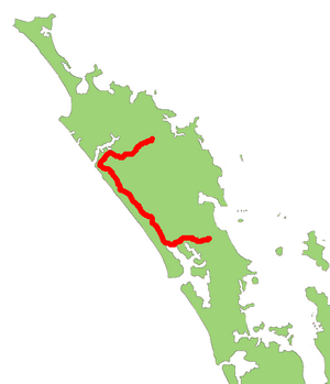
Государственное шоссе 12 (SH 12) - это шоссе в Новой Зеландии в дальнем севере от Северного острова . Он соединяется с SH 1 как в северном, так и в южном конце. Он проходит недалеко от западного побережья северного региона Новой Зеландии.
Маршрут
[ редактировать ]SH 12 starts in Ōhaeawai, running initially southwest to Kaikohe, during which it shares a short section of road with SH 15. It then turns roughly westwards, reaching the Hokianga harbour at its Omanaia River arm. It continues west, reaching Opononi and Ōmāpere at the mouth of the harbour, before turning southeast to parallel the coast. The highway briefly follows the valley of the Waimamaku River before winding through the Waipoua Kauri Forest, then follows the valley of the Kaihu River to Dargaville. At Dargaville, the highway meets SH 14, and continues southeastwards along the edge of the Wairoa River to Ruawai before turning eastwards. It briefly skirts the edge of the Arapaoa River arm of the Kaipara Harbour before passing through Paparoa and Maungaturoto and ending at its junction with SH 1 at Brynderwyn, 15 km (9.3 mi) south of Waipu.[1][unreliable source?][when?]
Major intersections
[edit]| Territorial authority | Location | km | mi | Destinations | Notes |
|---|---|---|---|---|---|
| Far North District | Ohaeawai | 0 | 0.0 | SH 12 begins 35°21′07″S 173°52′55″E / 35.351953°S 173.882060°E | |
| Kaikohe | 8.7 | 5.4 | SH 12/SH 15 concurrency begins | ||
| 10.3 | 6.4 | SH 12/SH 15 concurrency ends | |||
| Kaipara District | Dargaville | 142 | 88 | River Road – Te Kōpuru, Pouto | |
| 144.7 | 89.9 | ||||
| Brynderwyn | 214.3 | 133.2 | SH 12 ends 36°05′49″S 174°25′49″E / 36.096817°S 174.430256°E | ||
| |||||

See also
[edit]- List of New Zealand state highways
- List of roads and highways, for notable or famous roads worldwide
References
[edit]External links
[edit]
Эта статья, связанная с Новой Зеландии или дорожным транспортом, является заглушкой . Вы можете помочь Википедии, расширив ее . |