А2 автомагистраль (Греция)
 | |
|---|---|
| Автомагистраль 2 | |
| Egnatia Odos ЭГГАТИЯ ДОРОГА | |
 Маршрут egnatia odos | |
| Route information | |
| Part of | |
| Length | 670 km (420 mi) |
| Existed | 2009–present |
| Major junctions | |
| From | Igoumenitsa |
| To | Kipoi |
| Location | |
| Country | Greece |
| Regions | Epirus, Macedonia, Thrace |
| Highway system | |
| |
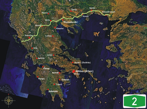
А2 автомагистраль A2 , также известная как Egnatia Odos ( греческий : egnatia road ), [ 1 ] [ 2 ] это шоссе с контролируемым доступом в северной Греции , которая проходит от западного порта Игуменец до восточной греческой границы в Кипои . Весь маршрут является частью греческой секции дороги E90 , которая проходит от Лиссабона , Португалии на западе и Захо , Ирак на востоке.
Автомобиль A2 работает в общей сложности 670 км (420 миль). Мегапроект начался в 1994 году и был завершен в 2009 году стоимостью 5,93 млрд евро (8,27 млрд долларов); [ 3 ] Он управлял государственной компанией Egnatia Odos, SA
География
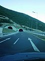
[ редактировать ]The route traverses the mountainous Greek regions of Epirus and Macedonia, crossing the Pindos and Vermio mountain ranges, which posed formidable engineering challenges. It includes 76 tunnels (with a combined length of 99 km / 61.5 miles) and 1,650 bridges. It is a limited-access highway with sophisticated electronic surveillance measures, SCADA controls for the lighting/tunnel ventilation, and advanced vehicle collision absorption measures.[4]
- Stretching: From the port of Igoumenitsa, Thesprotia to the border crossing of Kipoi, on the River Evros
- Total length: 670 kilometres
- Serving the regional units: Thesprotia – Ioannina – Grevena – Kozani – Imathia – Thessaloniki – Kavala – Xanthi – Rhodope – Evros.
- Linked with nine major vertical axes connecting to the neighbouring countries in the north (Albania, North Macedonia, Bulgaria, Turkey).
- Passing through the towns of: Igoumenitsa – Ioannina – Metsovo – Grevena – Kozani – Veroia – Thessaloniki – Kavala – Xanthi – Komotini – Alexandroupolis
- Linked to the Ports of: Igoumenitsa – Thessaloniki – Kavala – Alexandroupolis
- Linked to the Airports of: Ioannina – Kastoria – Kozani – Thessaloniki – Kavala – Alexandroupolis
- Technical characteristics: Two traffic lanes per direction, a central reserve and an emergency lane on the right.
- The area served accounts for:
- 36% of the country's total population
- 33% of its total gross national product
- In the primary sector, 54% of total farmland and 65% of total irrigated land
- In the secondary sector, 41% of total industrial employment, and
- 51% of total mining activity.
Part of its length, a section of about 360 km (220 mi) from Evros to Thessaloniki, parallels the ancient Roman Via Egnatia, which ran from modern Durrës in Albania to Thessaloniki and thence to Byzantium (now Istanbul, Turkey). The project has therefore been dubbed a modern Via Egnatia (in Greek, Egnatia Odos / Εγνατία Οδός). However, the parallel is not exact; the original Via Egnatia was much longer (1,120 km / 696 miles) and its western section, from Thessaloniki to the Adriatic Sea, ran much further north than the modern road.
The project has raised concerns for the survival of nearby sites of ecological and archaeological significance. The construction of the Pindos stretch (i.e. from Grevena to Ioannina) was delayed due to environmental concerns about the destruction of the habitat of the endangered brown bear. However, a new routing was proposed in 2003, and this part was completed by April 2009.
In addition to the main highway, three perpendicular auxiliary highways are under construction connecting the highway to important cities, ports and airports of Macedonia.
History
[edit]
94 km of the motorway had been built as part of other motorways, before the official project began in 1994. Between 1997 and 2004, 393 km of motorway were built.[5] The main part of the project was completed by 30 May 2009.[6] A final bridge was opened on 10 May 2014 [7]
Exit list
[edit]This article contains a bulleted list or table of intersections which should be presented in a properly formatted junction table. (November 2021) |
The exits of the completed sections of the A2 motorway:[8]
| Notes | |
|---|---|
| Under construction | |
| Planned | |

Галерея
[ редактировать ]-
-
 Egnatia Skin возле Asprovalta .
 -
 Диархос туннель neear ioannina .
 -
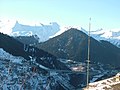 Egnatia Odos (A2) мост Metsovitikos, как видно из Metsovo
 -
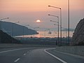 Рядом с портом Игуменки
 -
 Egnatia Odos возле Иоаннины , как видно из самолета.
 -
 Выход возле Козани
 -
 Панорамный вид туннеля Малакаси
 -
 Egnatia Odos возле Клиди .


Лечение 7000 участков высокого риска в Греции с EIB
[ редактировать ]В 2020 году EIB и EGNATIA ODOS стремятся к лечению средств на 7000 участков высокого риска в Греции. [ 9 ]
Ссылки
[ редактировать ]- ^ Делисо, Крис (27 сентября 2010 г.). «Вождение современного древнего шоссе Греции, Egnatia Odos» . Би -би -си путешествия . Лондон: BBC. Архивировано из оригинала 27 августа 2024 года . Получено 27 августа 2024 года .
- ^ Министерское решение doy/oiik/5776/2015 (FEK AAP '253/21.12.2015, pp. 2098–2099).
- ^ «Строительство автомагистрали Egnatia» . EGNATIA ODOS, SA . Архивировано из оригинала 19 августа 2018 года . Получено 18 августа 2018 года .
- ^ Основная дорожная мебель архив 2011-07-20 В The Wayback Machine , основное туннельное оборудование архивировано 2011-07-20 на The Wayback Machine
- ^ «Ардия Бридж стал дорогой Эгнатии» . К BHMA . 24 ноября 2008 г.
- ^ «Мечта о Эгнатии стала реальностью » . К BHMA . 7 июня 2009 г.
- ^ «Дорога Egnatia также была завершена » . ypodomes.com . Архивировано с оригинала 2015-01-24.
- ^ "Aftokinitodromos A2 - Egnatia Odos" . Автомагистрали-EXITS.com .
- ^ «Европейский инвестиционный банк для финансирования лечения 7000 участков высокого риска в Греции | etsc» .
Внешние ссылки
[ редактировать ]- Официальный веб-сайт Egnatia Odos SA Archived 2008-02-15 в The Wayback Machine (английская версия)

