Округ Гавайи, Гавайи

Округ Гавайи | |
|---|---|
 | |
 Флаг  Seal | |
 Location within the U.S. state of Hawaii | |
 Hawaii's location within the U.S. | |
| Coordinates: 19°35′N 155°30′W / 19.58°N 155.5°W | |
| Country | |
| State | |
| Founded | 1905 |
| Named for | Hawaii (Island) |
| Seat | Hilo |
| Largest community | Hilo |
| Government | |
| • Mayor | Mitch Roth |
| Area | |
| • Total | 5,086.70 sq mi (13,174.5 km2) |
| • Land | 4,028.02 sq mi (10,432.5 km2) |
| • Water | 1,058.69 sq mi (2,742.0 km2) 20.81% |
| Population (2020) | |
| • Total | 200,629 |
| • Density | 46/sq mi (17.7/km2) |
| Time zone | UTC−10 (Hawaii–Aleutian) |
| Congressional district | 2nd |
| Website | www |
Округ Гавайи ( Гавайцы : Калана о Гавайи ; официально известный как графство Гавайи ) - это графство в США на Гавайях на Гавайских островах . Он совместно с острова Гавайи , часто называемый «Большим островом», чтобы отличить его от штата в целом. Население переписи 2020 года составило 200 629 человек. [ 1 ] Курс округа Хило . нет включенных городов В округе Гавайи (см. Графства Гавайи ). Хило Микрополитный статистический район включает в себя весь округ Гавайи. У округа Гавайи есть мэра -мэра форма правительства . С точки зрения географии, округ Гавайи является наиболее обширным округом в штате и в самом южном округе в Соединенных Штатах.
Мэр округа Гавайи -Митч Рот, который вступил в должность в 2020 году. Законодательная власть возложена в Совете графства Гавайи из девяти человек.
Hawaii County is one of seven counties in the United States to share the same name as the state they are in (the other six are Arkansas County, Idaho County, Iowa County, New York County, Oklahoma County, and Utah County).[2]
Geography
[edit]Hawaii County has a total area of 5,086.70 square miles (13,174.5 km2); 4,028.02 square miles (10,432.5 km2) is land and 1,058.69 square miles (2,742.0 km2) is water[3] (mostly all off the ocean shoreline but counted in the total area by the U.S. Census Bureau). The county's land area comprises 62.7 percent of the state's land area. It is the highest percentage by any county in the United States. (Delaware's Sussex County comes in second at 48.0 percent, while Rhode Island's Providence County is third at 39.55 percent.)
Major highways
[edit]Adjacent county
[edit]- Maui County - northwest
Demographics
[edit]| Census | Pop. | Note | %± |
|---|---|---|---|
| 1900 | 46,843 | — | |
| 1910 | 55,382 | 18.2% | |
| 1920 | 64,895 | 17.2% | |
| 1930 | 73,325 | 13.0% | |
| 1940 | 73,276 | −0.1% | |
| 1950 | 68,350 | −6.7% | |
| 1960 | 61,332 | −10.3% | |
| 1970 | 63,468 | 3.5% | |
| 1980 | 92,053 | 45.0% | |
| 1990 | 120,317 | 30.7% | |
| 2000 | 148,677 | 23.6% | |
| 2010 | 185,079 | 24.5% | |
| 2020 | 200,629 | 8.4% | |
| 2023 (est.) | 207,615 | [4] | 3.5% |
As of 2010[update], the island had a resident population of 185,079.[5] There were 64,382 households in the county. The population density was 17.7/km2 (46/sq mi). There were 82,324 housing units at an average density of 8/km2 (21/sq mi). The racial makeup of the county was 34.5% White, 29.2% from two or more races, 22.6% Asian, 12.4% Native Hawaiian or other Pacific Islander and 0.7% African American; 11.8% of the population were Hispanics or Latinos of any race. The largest ancestry groups were:
- 9.8% Japanese
- 9.6% German
- 8.6% Filipino
- 8.5% Native Hawaiian
- 8.3% Portuguese
- 6.9% Irish
- 5.7% English
- 5.1% Puerto Rican
- 3.2% Mexican
- 2.5% French
- 2.2% Italian
- 1.9% Spanish
- 1.7% Scottish
- 1.5% Scotch-Irish
- 1.5% Swedish
- 1.1% Polish
- 1.1% Dutch
- 1.0% Norwegian
There were 64,382 households, out of which 32.2% had children under the age of 18 living with them, 50.6% were married couples living together, 13.2% had a woman whose husband did not live with her, and 30.4% were non-families. 23.1% of all households were made up of individuals, and 8.0% had someone living alone who was 65 years of age or older. The average household size was 2.75 and the average family size was 3.24.
The age distribution was 26.1% under 18, 8.2% from 18 to 24, 26.2% from 25 to 44, 26.0% from 45 to 64, and 13.5% who were 65 or older. The median age was 39 years. For every 100 females, there were 100 males. For every 100 females age 18 and over, there were 98 males.
41.3% of the people on Hawaii island are religious, meaning they affiliate with a religion. 18.4% are Catholic; 3.7% are of another Christian faith; 5.1% are LDS; 5.0% are of an Eastern faith; 0.1% are Muslim.[citation needed]
Government and infrastructure
[edit]County government
[edit]This article's factual accuracy may be compromised due to out-of-date information. The reason given is: Redistricted 2011 and expected to redistrict again late 2021. (September 2021) |
Executive authority is vested in the mayor of Hawaii County, who is elected for a four-year term. Since 2004, the election by the voters has been on a nonpartisan basis. In 2020, Mitch Roth was elected mayor, succeeding Harry Kim, who lost reelection after being defeated in the primary election.[6] Legislative authority is vested in a nine-member County Council. Members of the County Council are elected on a nonpartisan basis to two-year terms from single-member districts.[7] As of December 2016, Hawaii County Council has a female supermajority for the first time, with six women and three men.[8]
Administrative districts were originally based on the traditional land divisions called Moku of Ancient Hawaii. Some more heavily populated districts have since been split into North and South districts to make them more comparable on a population basis.
The number following each district is the Tax Map Key (TMK) number, used to locate state property information. They are assigned in a counter-clockwise order beginning on the eastern side of the island.[9]
| Nr. | District | Area mi2 |
Population 2000 |
moku | Map |
|---|---|---|---|---|---|
| 1 | Puna | 499.45 | 31,335 | Puna | 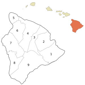
|
| 2 | South Hilo | 394.38 | 47,386 | Hilo | |
| 3 | North Hilo | 370.65 | 1,720 | Hilo | |
| 4 | Hāmākua | 580.50 | 6,108 | Hāmākua | |
| 5 | North Kohala | 132.92 | 6,038 | Kohala | |
| 6 | South Kohala | 351.72 | 13,131 | Kohala | |
| 7 | North Kona | 489.01 | 28,543 | Kona | |
| 8 | South Kona | 335.38 | 8,589 | Kona | |
| 9 | Kaʻū | 922.22 | 5,827 | Kaʻū | |
| Hawaiʻi County | 4028.02 | 148,677 | 6 moku |
County council districts do not directly match the property tax districts because of the variation in the population density of voters in urban areas to rural areas; Hilo & Kailua (Kailua-Kona) towns are densely populated areas, while other districts such as Kaʻū, Puna, Hāmākua, and North & South Kohala are more sparsely populated.[10]
Several government functions are administered at the county level that are at the state or municipal level in other states. For example, the county has its own office of liquor control.[11]
State government
[edit]Hawaii Department of Public Safety previously operated the Kulani Correctional Facility in Hawaii County, on the Island of Hawaii.[12] In 2009, the Hawaii Department of Public Safety announced that Kulani Correctional Facility would close.[13]
Presidential election results
[edit]| Year | Republican | Democratic | Third party(ies) | |||
|---|---|---|---|---|---|---|
| No. | % | No. | % | No. | % | |
| 2020 | 26,897 | 30.63% | 58,731 | 66.88% | 2,186 | 2.49% |
| 2016 | 17,501 | 26.98% | 41,259 | 63.61% | 6,107 | 9.41% |
| 2012 | 14,753 | 23.25% | 47,224 | 74.42% | 1,477 | 2.33% |
| 2008 | 14,866 | 22.22% | 50,819 | 75.94% | 1,231 | 1.84% |
| 2004 | 22,032 | 38.18% | 35,116 | 60.86% | 554 | 0.96% |
| 2000 | 17,050 | 33.52% | 28,670 | 56.37% | 5,140 | 10.11% |
| 1996 | 13,516 | 27.60% | 27,262 | 55.66% | 8,199 | 16.74% |
| 1992 | 15,460 | 30.36% | 25,725 | 50.52% | 9,731 | 19.11% |
| 1988 | 17,125 | 41.00% | 24,091 | 57.68% | 552 | 1.32% |
| 1984 | 20,707 | 52.90% | 17,866 | 45.64% | 570 | 1.46% |
| 1980 | 14,247 | 39.73% | 17,630 | 49.16% | 3,984 | 11.11% |
| 1976 | 15,366 | 48.37% | 15,960 | 50.24% | 439 | 1.38% |
| 1972 | 16,832 | 59.09% | 11,652 | 40.91% | 0 | 0.00% |
| 1968 | 9,625 | 37.41% | 15,819 | 61.49% | 283 | 1.10% |
| 1964 | 4,962 | 19.87% | 20,011 | 80.13% | 0 | 0.00% |
| 1960 | 12,251 | 51.46% | 11,557 | 48.54% | 0 | 0.00% |
Localities
[edit]Census-designated places
[edit]- Ainaloa
- Black Sands
- Captain Cook
- Discovery Harbour
- Eden Roc
- Fern Acres
- Fern Forest
- Halaula
- Hawaiian Acres
- Hawaiian Beaches
- Hawaiian Ocean View
- Hawaiian Paradise Park
- Hawi
- Hilo
- Holualoa
- Honalo
- Honaunau-Napoopoo
- Honokaa
- Honomu
- Kahaluu-Keauhou
- Kailua
- Kaiminani
- Kalaoa
- Kalapana
- Kaloko
- Kamaili
- Kapaau
- Keaau
- Kealakekua
- Kukuihaele
- Kurtistown
- Laupahoehoe
- Leilani Estates
- Mauna Loa Estates
- Mountain View
- Naalehu
- Nanawale Estates
- Orchidlands Estates
- Paauilo
- Pahala
- Pahoa
- Papaikou
- Paukaa
- Pepeekeo
- Puako
- Royal Hawaiian Estates
- Seaview
- Tiki Gardens
- Volcano
- Volcano Golf Course
- Waikoloa Beach Resort
- Waikoloa Village
- Waimea
- Wainaku
- Waiohinu
Other communities
[edit]National protected areas
[edit]- Ala Kahakai National Historic Trail
- Hakalau Forest National Wildlife Refuge
- Hawaii Volcanoes National Park
- Kaloko-Honokōhau National Historical Park
- Kona Forest National Wildlife Refuge
- Puʻuhonua o Hōnaunau National Historical Park
- Puʻukoholā Heiau National Historic Site
Economy
[edit]Top employers
[edit]According to the county's 2021 Annual Comprehensive Financial Report,[15] the top employers in the county are the following:
| # | Employer | # of Employees |
|---|---|---|
| 1 | State of Hawaii | 16,700 |
| 2 | Kamehameha Schools, Hawai'i Island | 3,380 |
| 3 | Hawaii County | 2,800 |
| 4 | United States Government | 1,300 |
| 5 | Mauna Kea Beach Hotel | 1,100 |
| 6 | Four Seasons Resort Hualalai | 1,003 |
| 7 | KTA Super Stores | 900 |
| 8 | Hilton Waikoloa Village | 850 |
| 9 | Фэрмонт орхидея | 560 |
| 10 | Waikoloa Beach Marriott Resort | 259 |
Образование
[ редактировать ]Министерство образования на Гавайях управляет государственными школами в округе Гавайи. [ 16 ]
Сестринские города
[ редактировать ]округа Гавайи Сестринские города : [ 17 ]
Ссылки
[ редактировать ]- ^ «Гавайи: перепись 2020 года» . Бюро переписи Соединенных Штатов . Получено 4 апреля 2022 года .
- ^ Джозеф Натан Кейн; Чарльз Карри Айкен (2005). Американские округа: происхождение названий округа, даты творения и данные населения, 1950-2000 . Пресс чучела. ISBN 978-0-8108-5036-1 .
- ^ «Перепись 2000 американских газетчиков: округа» . Перепись Соединенных Штатов. Архивировано из оригинала 12 мая 2011 года . Получено 13 февраля 2011 года .
- ^ «Ежегодные оценки населения резидентов для округов: с 1 апреля 2020 года по 1 июля 2023 года» . Бюро переписи Соединенных Штатов . Получено 31 марта 2024 года .
- ^ «QuickFacts округа Гавайи из Бюро переписей США» . Архивировано из оригинала 13 июля 2011 года . Получено 28 июня 2014 года .
- ^ «Офис мэра» . Официальный веб -сайт . Графство Гавайи . Получено 11 декабря 2020 года .
- ^ «Совет графства Гавайи» . Официальный веб -сайт . Архивировано из оригинала 8 июля 2011 года . Получено 27 марта 2010 года .
- ^ «Poindexter вкладывает, чтобы стать председателем совета; возглавит первую женскую супер-большинство совета по истории графства | Гавайи Tribune-Herald» . Архивировано из оригинала 28 декабря 2017 года . Получено 28 декабря 2017 года .
- ^ Округ Гавайи: 2000 [ Постоянная мертвая ссылка ]
- ^ «Совет графства Гавайи» . Официальный веб -сайт . Архивировано из оригинала 8 июля 2011 года . Получено 27 марта 2010 года .
- ^ «Офис контроля спиртных напитков» . Веб -сайт округа Гавайи . Архивировано с оригинала 23 ноября 2010 года . Получено 25 декабря 2010 года .
- ^ " Кулани исправительное учреждение ". Гавайский департамент общественной безопасности . Получено 30 сентября 2010 года.
- ^ « Закрытие Кулани экономит 2,8 млн долларов в год; объект, чтобы помочь молодежи из группы риска ». Гавайский департамент общественной безопасности . Июль 2009 г. Получено 30 сентября 2010 года.
- ^ Лейп, Дэвид. «Атлас Дейва Лейпа из президентских выборов в США» . uselectionatlas.org . Получено 26 мая 2017 года .
- ^ Сако, Динна. «Годовой комплексный финансовый отчет 2021» . records.hawaiicounty.gov . Получено 13 ноября 2023 года .
- ^ «Перепись 2020 года - Справочная карта школьного округа: округ Гавайи, HI» (PDF) . Бюро переписей США . Получено 22 июля 2022 года . - текстовый список
- ^ «Официальные родственные города округа Гавайи 2021» . Графство Гавайи. Архивировано из оригинала 31 мая 2022 года . Получено 20 декабря 2021 года .
Внешние ссылки
[ редактировать ]- Официальный округа Гавайи сайт
- Гавайский национальный парк вулканов
- Экономическое образование от пересмотра Генерального плана округа Гавайи
 СМИ, связанные с Гавайями (остров) в Wikimedia Commons
19 ° 35,65 ° 15 ° 30 ' 5 ° С 155,500 ° С
Острова, муниципалитеты и общины округа Гавайи, Гавайи , США. |
|---|

Состояние Гавайи |
|---|