КЛЕБУРНА, Округ, Алабама

Клеберн округ | |
|---|---|
 Здание суда округа Клеберн в Хефлине в 2012 году | |
 Флаг  Seal | |
 Location within the U.S. state of Alabama | |
 Alabama's location within the U.S. | |
| Coordinates: 33°40′38″N 85°30′09″W / 33.6772°N 85.5025°W | |
| Country | |
| State | |
| Founded | December 6, 1866 |
| Named for | Patrick Cleburne |
| Seat | Heflin |
| Largest city | Heflin |
| Area | |
| • Total | 561 sq mi (1,450 km2) |
| • Land | 560 sq mi (1,500 km2) |
| • Water | 0.9 sq mi (2 km2) 0.2% |
| Population (2020) | |
| • Total | 15,056 |
| • Estimate (2023) | 15,639 |
| • Density | 27/sq mi (10/km2) |
| Time zone | UTC−6 (Central) |
| • Summer (DST) | UTC−5 (CDT) |
| Congressional district | 3rd |
| Website | www |
| |
Округ Клиберн - это округ , расположенный в восточной центральной части США штата Алабама . По состоянию на переписи 2020 года население было 15 056. [ 1 ] Его место в округе - Хефлин . [ 2 ] Его название в честь Патрика Р. Клиберна из Арканзаса [ 3 ] который поднялся до звания генерал -майора в армии штатов Конфедерации . Восточная сторона графства граничит с штатом Грузия .
История
[ редактировать ]Округ Клиберн был основан 6 декабря 1866 года актом законодательного органа штата. Округ был сделан из территории в Бентоне (ныне Калхун), Рэндольф и Талладега. В 1867 году Эдвардсвилл стал местом округа. [ 4 ] В 1905 году были проведены выборы, чтобы перенести место округа в Хефлин. Результат этих выборов, которые согласились переместить место, был обжарен в Верховном суде, который решил 1 июля 1906 года поддержать результаты выборов. Хефлин все еще место в округе. [ 5 ] Хефлин когда -то думал как центр для близлежащих фермеров, чтобы отправить свой хлопок. [ 6 ] Shortly after the Civil War, a group of northern investors created the town of Fruithurst in Cleburne County as part of a wine-growing project. Fruithurst became a boomtown shortly thereafter.[7]
Geography
[edit]
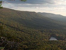

According to the United States Census Bureau, the county has a total area of 561 square miles (1,450 km2), of which 560 square miles (1,500 km2) is land and 0.9 square miles (2.3 km2) (0.2%) is water.[8] It is the fourth-smallest county in Alabama by land area and second-largest by total area. Cleburne County is home to Alabama's highest natural point on Cheaha Mountain which is part of the southernmost mountain range in the Blue Ridge Mountains.
Adjacent counties
[edit]- Cherokee County – north
- Polk County, Georgia – northeast
- Haralson County, Georgia – east
- Carroll County, Georgia – southeast
- Randolph County – south
- Clay County – southwest
- Talladega County – southwest
- Calhoun County – west
National protected area
[edit]- Talladega National Forest (part)
Transportation
[edit]Major highways
[edit]Rail
[edit]Demographics
[edit]| Census | Pop. | Note | %± |
|---|---|---|---|
| 1870 | 8,017 | — | |
| 1880 | 10,976 | 36.9% | |
| 1890 | 13,218 | 20.4% | |
| 1900 | 13,206 | −0.1% | |
| 1910 | 13,385 | 1.4% | |
| 1920 | 13,360 | −0.2% | |
| 1930 | 12,877 | −3.6% | |
| 1940 | 13,629 | 5.8% | |
| 1950 | 11,904 | −12.7% | |
| 1960 | 10,911 | −8.3% | |
| 1970 | 10,996 | 0.8% | |
| 1980 | 12,595 | 14.5% | |
| 1990 | 12,730 | 1.1% | |
| 2000 | 14,123 | 10.9% | |
| 2010 | 14,972 | 6.0% | |
| 2020 | 15,056 | 0.6% | |
| 2023 (est.) | 15,639 | [9] | 3.9% |
| U.S. Decennial Census[10] 1790–1960[11] 1900–1990[12] 1990–2000[13] 2010–2020[1] | |||
2020 census
[edit]| Race / Ethnicity (NH = Non-Hispanic) | Pop 2000[14] | Pop 2010[15] | Pop 2020[16] | % 2000 | % 2010 | % 2020 |
|---|---|---|---|---|---|---|
| White alone (NH) | 13,235 | 13,956 | 13,740 | 93.71% | 93.21% | 91.26% |
| Black or African American alone (NH) | 521 | 494 | 457 | 3.69% | 3.30% | 3.04% |
| Native American or Alaska Native alone (NH) | 41 | 50 | 42 | 0.29% | 0.33% | 0.28% |
| Asian alone (NH) | 19 | 23 | 21 | 0.13% | 0.15% | 0.14% |
| Pacific Islander alone (NH) | 1 | 1 | 2 | 0.01% | 0.01% | 0.01% |
| Other Race alone (NH) | 1 | 4 | 16 | 0.01% | 0.03% | 0.11% |
| Mixed Race or Multi-Racial (NH) | 107 | 137 | 494 | 0.76% | 0.92% | 3.28% |
| Hispanic or Latino (any race) | 198 | 307 | 284 | 1.40% | 2.05% | 1.89% |
| Total | 14,123 | 14,972 | 15,056 | 100.00% | 100.00% | 100.00% |
As of the 2020 United States census, there were 15,056 people, 5,680 households, and 3,806 families residing in the county.
2010 census
[edit]As of the census[17] of 2010, there were 14,972 people, 5,891 households, and 4,196 families living in the county. The population density was 27 people per square mile (10 people/km2). There were 6,718 housing units at an average density of 11 units per square mile (4.2 units/km2). The racial makeup of the county was 94.0% White (non-Hispanic), 3.3% Black or African American, 0.30% Native American, 0.1% Asian, 0.1% Pacific Islander, 1.0% from other races, and 1.1% from two or more races. 2.1% of the population were Hispanic or Latino of any race.
There were 5,891 households, out of which 28.7% had children under the age of 18 living with them, 56.2% were married couples living together, 10.3% had a female householder with no husband present, and 28.8% were non-families. 25.1% of all households were made up of individuals, and 11.2% had someone living alone who was 65 years of age or older. The average household size was 2.51 and the average family size was 2.99.
In the county, the population was spread out, with 23.7% under the age of 18, 7.8% from 18 to 24, 24.6% from 25 to 44, 28.1% from 45 to 64, and 15.8% who were 65 years of age or older. The median age was 40.6 years. For every 100 females there were 99.1 males. For every 100 females age 18 and over, there were 100.9 males.
The median income for a household in the county was $36,077, and the median income for a family was $41,585. Males had a median income of $39,709 versus $26,229 for females. The per capita income for the county was $17,490. About 11.6% of families and 17.1% of the population were below the poverty line, including 24.0% of those under age 18 and 13.7% of those age 65 or over.
2000 census
[edit]As of the census[18] of 2000, there were 14,123 people, 5,590 households, and 4,125 families living in the county. The population density was 25 people per square mile (9.7 people/km2). There were 6,189 housing units at an average density of 11 units per square mile (4.2 units/km2). The racial makeup of the county was 89.74% White (non-Hispanic), 7.70% Black or African American, 0.30% Native American, 0.14% Asian, 0.01% Pacific Islander, 0.34% from other races, and 0.77% from two or more races. 3.40% of the population were Hispanic or Latino of any race.
There were 5,590 households, out of which 32.80% had children under the age of 18 living with them, 61.40% were married couples living together, 8.70% had a female householder with no husband present, and 26.20% were non-families. 23.00% of all households were made up of individuals, and 10.30% had someone living alone who was 65 years of age or older. The average household size was 2.51 and the average family size was 2.95.
In the county, the population was spread out, with 24.30% under the age of 18, 8.20% from 18 to 24, 28.50% from 25 to 44, 25.30% from 45 to 64, and 13.70% who were 65 years of age or older. The median age was 38 years. For every 100 females there were 99.30 males. For every 100 females age 18 and over, there were 96.40 males.
The median income for a household in the county was $30,820, and the median income for a family was $35,579. Males had a median income of $29,752 versus $18,840 for females. The per capita income for the county was $14,762. About 10.90% of families and 13.90% of the population were below the poverty line, including 16.10% of those under age 18 and 20.10% of those age 65 or over.
Education
[edit]Cleburne County contains two public school districts. There are approximately 2,500 students in public PK-12 schools in Cleburne County. Much of the county is serviced by the single county school district, but the northern portion of the county falls under Piedmont City School District, the seat of which is in Calhoun County.[19]
Districts
[edit]School districts include:[20]
Politics
[edit]Although not to the same extent as Winston or Chilton Counties, Cleburne County was at least in Presidential elections a Republican island in overwhelmingly Democratic Alabama during the "Solid South" era due to its unsuitable terrain for slave-based plantation agriculture. This led to considerable Populist support during the period of "Redemption" by white Democrats, which produced later support for the Republican Party even when in most of Alabama whites associated the "Party of Lincoln" with occupation and black political power.
Since the end of the dealigned political era of the 1960s and 1970s, Cleburne County has followed the same trajectory towards overwhelming Republican dominance as the rest of Appalachia: in 2020, Joe Biden gained nine percent of the county's vote, a figure less than George McGovern in his landslide 1972 defeat.
| Year | Republican | Democratic | Third party(ies) | |||
|---|---|---|---|---|---|---|
| No. | % | No. | % | No. | % | |
| 2020 | 6,484 | 89.72% | 675 | 9.34% | 68 | 0.94% |
| 2016 | 5,764 | 87.43% | 684 | 10.37% | 145 | 2.20% |
| 2012 | 5,272 | 83.43% | 971 | 15.37% | 76 | 1.20% |
| 2008 | 5,216 | 80.35% | 1,168 | 17.99% | 108 | 1.66% |
| 2004 | 4,370 | 75.37% | 1,391 | 23.99% | 37 | 0.64% |
| 2000 | 3,333 | 65.46% | 1,664 | 32.68% | 95 | 1.87% |
| 1996 | 2,063 | 48.64% | 1,737 | 40.96% | 441 | 10.40% |
| 1992 | 2,425 | 46.31% | 2,144 | 40.94% | 668 | 12.76% |
| 1988 | 3,071 | 68.40% | 1,383 | 30.80% | 36 | 0.80% |
| 1984 | 3,259 | 70.50% | 1,238 | 26.78% | 126 | 2.73% |
| 1980 | 2,389 | 52.78% | 2,050 | 45.29% | 87 | 1.92% |
| 1976 | 1,436 | 36.07% | 2,490 | 62.55% | 55 | 1.38% |
| 1972 | 3,420 | 85.20% | 581 | 14.47% | 13 | 0.32% |
| 1968 | 485 | 12.14% | 160 | 4.01% | 3,350 | 83.85% |
| 1964 | 2,156 | 76.24% | 0 | 0.00% | 672 | 23.76% |
| 1960 | 1,008 | 39.97% | 1,510 | 59.87% | 4 | 0.16% |
| 1956 | 1,056 | 42.75% | 1,407 | 56.96% | 7 | 0.28% |
| 1952 | 792 | 33.64% | 1,557 | 66.14% | 5 | 0.21% |
| 1948 | 317 | 30.87% | 0 | 0.00% | 710 | 69.13% |
| 1944 | 504 | 34.57% | 948 | 65.02% | 6 | 0.41% |
| 1940 | 434 | 24.00% | 1,369 | 75.72% | 5 | 0.28% |
| 1936 | 543 | 30.75% | 1,212 | 68.63% | 11 | 0.62% |
| 1932 | 405 | 22.35% | 1,403 | 77.43% | 4 | 0.22% |
| 1928 | 1,108 | 58.25% | 794 | 41.75% | 0 | 0.00% |
| 1924 | 696 | 51.18% | 622 | 45.74% | 42 | 3.09% |
| 1920 | 971 | 58.60% | 684 | 41.28% | 2 | 0.12% |
| 1916 | 578 | 42.75% | 760 | 56.21% | 14 | 1.04% |
| 1912 | 133 | 9.96% | 691 | 51.72% | 512 | 38.32% |
| 1908 | 357 | 49.86% | 278 | 38.83% | 81 | 11.31% |
| 1904 | 414 | 35.94% | 701 | 60.85% | 37 | 3.21% |
Communities
[edit]City
[edit]- Heflin (county seat)
Towns
[edit]Census-designated place
[edit]Unincorporated communities
[edit]See also
[edit]- National Register of Historic Places listings in Cleburne County, Alabama
- Properties on the Alabama Register of Landmarks and Heritage in Cleburne County, Alabama
- Shoal Creek Church
- Cleburne County School District
References
[edit]- ^ Jump up to: a b "State & County QuickFacts". United States Census Bureau. Retrieved September 10, 2023.
- ^ "Find a County". National Association of Counties. Archived from the original on May 31, 2011. Retrieved June 7, 2011.
- ^ Gannett, Henry (1905). The Origin of Certain Place Names in the United States. Govt. Print. Off. pp. 84.
- ^ "Cleburne County, Alabama history, ADAH". www.archives.state.al.us. Archived from the original on March 5, 2012. Retrieved June 23, 2018.
- ^ "City of Heflin Website - City Information - Heflin, AL". www.cityofheflin.org. Retrieved June 23, 2018.
- ^ Cleburne County By Wayne Ruple page 33
- ^ Cleburne County By Wayne Ruple page 11
- ^ "2010 Census Gazetteer Files". United States Census Bureau. August 22, 2012. Retrieved August 22, 2015.
- ^ "Annual Estimates of the Resident Population for Counties: April 1, 2020 to July 1, 2023". United States Census Bureau. Retrieved March 27, 2024.
- ^ "U.S. Decennial Census". United States Census Bureau. Retrieved August 22, 2015.
- ^ "Historical Census Browser". University of Virginia Library. Archived from the original on August 11, 2012. Retrieved August 22, 2015.
- ^ Forstall, Richard L., ed. (March 24, 1995). "Population of Counties by Decennial Census: 1900 to 1990". United States Census Bureau. Retrieved August 22, 2015.
- ^ "Census 2000 PHC-T-4. Ranking Tables for Counties: 1990 and 2000" (PDF). United States Census Bureau. April 2, 2001. Retrieved August 22, 2015.
- ^ "P004 Hispanic or Latino, and Not Hispanic or Latino by Race – 2000: DEC Summary File 1 – Cleburne County, Alabama". United States Census Bureau.
- ^ "P2 Hispanic or Latino, and Not Hispanic or Latino by Race – 2010: DEC Redistricting Data (PL 94-171) – Cleburne County, Alabama". United States Census Bureau.
- ^ "P2 Hispanic or Latino, and Not Hispanic or Latino by Race – 2020: DEC Redistricting Data (PL 94-171) – Cleburne County, Alabama". United States Census Bureau.
- ^ "U.S. Census website". United States Census Bureau. Retrieved July 18, 2015.
- ^ "U.S. Census website". United States Census Bureau. Retrieved May 14, 2011.
- ^ "Search for Public School Districts - Cleburne County, AL". National Center for Education Statistics. Institute of Education Sciences. Retrieved October 2, 2022.
- ^ «Перепись 2020 года - Справочная карта школьного округа: округ Клеберн, Алабама» (PDF) . Бюро переписей США . Получено 2 октября 2022 года . Текстовый список .
- ^ «Атлас Дейва Лейпа из президентских выборов в США» . Получено 10 декабря 2016 года .
Внешние ссылки
[ редактировать ]33 ° 40′38 ″ с.ш. 85 ° 30'09 ″ в стр. / 33,67722 ° с.ш. 85,50250 ° С
Места рядом с округом Клеберн, штат Алабама |
|---|
Муниципалитеты и общины округа Клеберн, штат Алабама , США. |
|---|