Орулия осведомлена о подразделении

Орулия осведомлена о подразделении | |
|---|---|
Подразделение | |
 | |
| Координаты: 23 ° 11′N 86 ° 13′E / 23,19 ° N 86,22 ° E | |
| Страна | |
| Состояние | Западная Бенгалия |
| Округ | Пурулия |
| Штаб -квартира | Пурулия |
| Area | |
| • Total | 1,474.81 km2 (569.43 sq mi) |
| Population (2011) | |
| • Total | 878,373 |
| • Density | 600/km2 (1,500/sq mi) |
| Languages | |
| • Official | Bengali, English |
| Time zone | UTC+5:30 (IST) |
| ISO 3166 code | IN-WB |
| Vehicle registration | WB |
| Website | http://purulia.gov.in/ |
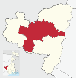
Подразделение Пурулии Садар является подразделом района Пурулия в штате Западная , Индия Бенгалия
История
[ редактировать ]Район Пурулия был разделен на четыре подразделения: «Пурулия Садар», «Манбазар», «Джальда» и «Рагхунатпур», с 6 апреля 2017 года, согласно приказу № 100-AR/P/2R-2/1999 от 30 марта 2017 Правительство Западной Бенгалии, в газете Калькутта от 30 марта 2017 года. [ 1 ]
Подразделения
[ редактировать ]Район Пурулия разделен на следующие административные подразделения: [ 2 ] [ 3 ] [ 4 ]
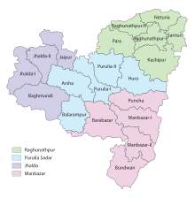
| Subdivision | Headquarter | Area km2 |
Population (2011) |
Rural Population % (2011) |
Urban Population % (2011) |
|---|---|---|---|---|---|
| Purulia Sadar | Purulia | 1,474.81 | 878,373 | 81.42 | 18.58 |
| Manbazar | Manbazar | 1,766.55 | 640,588 | 96.32 | 3.68 |
| Jhalda | Jhalda | 1,233.97 | 573,771 | 91.02 | 8.98 |
| Raghunathpur | Raghunathpur | 1,733.01 | 838,128 | 83.80 | 16.20 |
| Purulia district | Purulia | 6208.34 | 2,930,860 | 87.24 | 12.76 |
Note: The 2011 census data has been recast as per reorganisation of the subdivisions. There may be minor variations.

5miles
Hills
M: municipality, CT: census town, R: rural/ urban centre, H: historical/ religious centre, F: facility
Owing to space constraints in the small map, the actual locations in a larger map may vary slightly
Police stations
[edit]Police stations in the Purulia Sadar subdivision have the following features and jurisdiction:[2][3][5]
| Police Station | Area covered km2 |
Inter-state border km |
Municipal Town | CD block |
|---|---|---|---|---|
| Arsha | 187.5 | - | - | Arsha |
| Hura | 382.21 | - | - | Hura |
| Purulia (Town) | 13.9 | - | Purulia | Purulia I, Purulia II |
| Purulia (Muffasil) | 534.47 | - | - | Purulia I, Purulia II |
| Purulia Sadar Women | - | - | Purulia, Jhalda | Purulia (Muffasil), Kotshila, Arsha, Jhalda, Jaypur police stations area |
| Balarampur | 299.5 | 12.39 | - | Balarampur |
Blocks
[edit]Community development blocks in Purulia Sadar subdivision are:[2][3][4]

| CD block | Headquarters | Area km2 |
Population (2011) |
SC % | ST % | Literacy Rate % |
Census Towns |
|---|---|---|---|---|---|---|---|
| Arsha | Sirkabad | 375.04 | 154,736 | 11.82 | 21.69 | 54.78 | |
| Balarampur | Baghadih | 300.88 | 137.950 | 11.91 | 31.71 | 60.40 | 1 |
| Hura | Hura | 382.21 | 143,575 | 19.56 | 25.46 | 68.79 | |
| Purulia I | Chakda, PO Kotlui | 281.50 | 151,188 | 17.15 | 8.37 | 78.37 | 1 |
| Purulia II | Bongabari, PO Vivekanandanagar |
310.10 | 169,488 | 27.16 | 4.85 | 63.39 | 2 |
Gram panchayats
[edit]Gram panchayats in Purulia Sadar subdivision are :[2][6]
- Arsha: Arsha, Chatuhansa, Hensla, Puara, Beldih, Hetgugui, Mankiary and Sirkabad.
- Balarampur block: Balarampur, Bela, Genrua, Tentlow, Baraurma, Darda and Ghatbera–Kerowa.
- Hura block: Chatumadar, Jabarrah, Ladhurka, Rakhera–Bispuria, Daldali, Kalabani, Lakhanpur, Hura, Keshergarh and Maguria–Lalpur.
- Purulia–I block: Bhandarpuara–Chipida, Dimdiha, Lagda, Durku, Manara, Chakaltore, Garafusra and Sonaijuri.
- Purulia–II block: Agoya–Narra, Chharradumdumi, Hutmura, Belma, Ghonga, Pindra, Bhangra, Golamara and Raghabpur.
Education
[edit]Given in the table below is a comprehensive picture of the education scenario in Purulia district, after reorganisation of the district in 2017, with data for the year 2013-14. (There may be minor variations because of data recasting).:[2][3]
| Subdivision | Primary School |
Middle School |
High School |
Higher Secondary School |
General College, Univ |
Technical / Professional Instt |
Non-formal Education | |||||||
|---|---|---|---|---|---|---|---|---|---|---|---|---|---|---|
| Institution | Student | Institution | Student | Institution | Student | Institution | Student | Institution | Student | Institution | Student | Institution | Student | |
| Purulia Sadar | 818 | 87,425 | 114 | 7,292 | 26 | 11,345 | 83 | 80,138 | 6 | 12,463 | 11 | 1,806 | 1,461 | 49,234 |
| Manbazar | 832 | 59,105 | 121 | 4,141 | 21 | 7,615 | 64 | 63,466 | 5 | 5,441 | 3 | 256 | 1,371 | 41,267 |
| Jhalda | 533 | 53,629 | 67 | 3,453 | 2 | 1,415 | 47 | 55,492 | 6 | 2,332 | 2 | 98 | 836 | 34,779 |
| Raghunathpur | 818 | 72,073 | 126 | 8,925 | 31 | 16,055 | 67 | 68,188 | 4 | 7,007 | 5 | 649 | 1,761 | 45,472 |
| Purulia district | 3,001 | 272,232 | 428 | 23,811 | 80 | 36,430 | 261 | 267,284 | 21 | 27,243 | 21 | 3.009 | 5,429 | 170,752 |
Note: Primary schools include junior basic schools; middle schools, high schools and higher secondary schools include madrasahs; technical schools include junior technical schools, junior government polytechnics, industrial technical institutes, industrial training centres, nursing training institutes etc.; technical and professional colleges include engineering colleges, medical colleges, para-medical institutes, management colleges, teachers training and nursing training colleges, law colleges, art colleges, music colleges etc. Special and non-formal education centres include sishu siksha kendras, madhyamik siksha kendras, centres of Rabindra mukta vidyalaya, recognised Sanskrit tols, institutions for the blind and other handicapped persons, Anganwadi centres, reformatory schools etc.[3]
Educational institutions
[edit]The following institutions are located in Purulia Sadar subdivision:
- Sidho Kanho Birsha University was established in 2010 at Purulia.[7]
- Purulia Government Medical College & Hospital is located at Hatuara, Purulia.[8]
- Jagannath Kishore College was established at Purulia in 1948.[9]
- Nistarini Women's College was established in 1957 at Purulia.[10]
- Arsha College was established at Arsha in 2009.[11]
- Balarampur College was established at Rangadih, Balarampur in 1985.[12]
- Mahatma Gandhi College was established at Daldali, Lalpur in 1981.[13]
Healthcare
[edit]The table below (all data in numbers) presents an overview of the medical facilities available and patients treated in the hospitals, health centres and sub-centres in 2014 in Purulia district, after reorganisation of the district in 2017, with data for the year 2013-14. (There may be minor variations because of data recasting).:[2][3]
| Subdivision | Health & Family Welfare Deptt, WB | Other State Govt Deptts |
Local bodies |
Central Govt Deptts / PSUs |
NGO / Private Nursing Homes |
Total | Total Number of Beds |
Total Number of Doctors* |
Indoor Patients |
Outdoor Patients | |||
|---|---|---|---|---|---|---|---|---|---|---|---|---|---|
| Hospitals |
Rural Hospitals |
Block Primary Health Centres |
Primary Health Centres | ||||||||||
| Purulia Sadar | 2 | 2 | 3 | 13 | 2 | - | - | 9 | 31 | 1,203 | 96 | 209,390 | 1,626,712 |
| Manbazar | - | 1 | 4 | 14 | - | - | - | - | 19 | 254 | 40 | 35,184 | 990,561 |
| Jhalda | - | 1 | 3 | 10 | - | - | - | - | 15 | 196 | 23 | 28,522 | 820,961 |
| Raghunathpur | 1 | 1 | 4 | 13 | - | - | 1 | 2 | 22 | 835 | 77 | 55,866 | 1,071,786 |
| Purulia district | 3 | 5 | 14 | 50 | 2 | - | 1 | 12 | 87 | 2,488 | 236 | 328,962 | 4,510,020 |
.* Excluding nursing homes.
Medical facilities
[edit]Medical facilities in Purulia Sadar subdivision are as follows:
Hospitals: (Name, location, beds) [14]
- Deben Mahato Hospital (District Hospital), Purulia M, 506 beds
- Purulia Jail Hospital, Purulia M, 33 beds
- Purulia Police Hospital, Purulia M, 20 beds
- Purulia Mental Hospital, Purulia M, 200 beds
Rural Hospitals: (Name, CD block, location, beds) [15]
- Chakaltore Rural Hospital, Purulia I CD block, Chakaltor, 30 beds
- Kushtor Rural Hospital, Purulia II CD block, Kustor, 30 beds
- Hura Rural Hospital, Hura CD block, Hura, 30 beds
- Bansgarh Rural Hospital, Balarampur CD block, Rangadih, 30 beds
- Sirkabad Rural Hospital, Arsha CD block, Sirkabad, 30 beds
Primary Health Centres : (CD block-wise)(CD block, PHC location, beds)[16]
- Purulia I CD block: Pichasi (10), Belkuri (2), Lagda (6)
- Purulia II CD block: Hutmura (10), Chayanpur (6)
- Arsha CD block: Kantadih (4), Arsha (10)
- Balarampur CD block: Kerwa (10), Nekray (6), Malti (6)
- Hura CD block: Chatumadar (4), Khairipihira (4), Ladurkha (10)
Electoral constituencies
[edit]Lok Sabha (parliamentary) and Vidhan Sabha (state assembly) constituencies in Purulia district were as follows:
| Lok Sabha constituency | Vidhan Sabha constituency | Reservation | CD Block and/or Gram panchayat |
|---|---|---|---|
| Purulia | Balarampur | None | Balarampur CD Block; Chakaltore, Dimdiha, Durku, Garafusra, Lagda and Sonaijuri gram panchayats of Purulia I CD Block; and Chatu Hansa, Hensla and Puara gram panchayats of Arsha CD Block.[17] |
| Baghmundi | None | Jhalda municipality; Jhalda I and Baghmundi CD Blocks; Hetgugui and Sirkabad gram panchayats of Arsha CD Block.[17] | |
| Joypur | None | Joypur and Jhalda II CD Blocks; Arsha, Beldih and Manikary gram panchayats of Arsha CD Block.[17] | |
| Purulia | None | Purulia municipality; Purulia II CD Block; Bhandar Purachipida and Manara gram panchayats of Purulia I CD Block.[17] | |
| Manbazar | ST | Manbazar I and Puncha CD Blocks; Chatumadar, Daldali and Manguria Lalpur gram panchayats of Hura CD Block.[17] | |
| Kashipur | None | Kashipur CD Block; Hura, Jabarrah, Kalabani, Keshargarh, Ladhurka, Lakhanpur and Rakhera Bishpuri gram panchayats of Hura CD Block.[17] | |
| Para | SC | Para and Raghunathpur II CD Blocks.[17] | |
| Bankura | Raghunathpur | SC | Raghunathpur municipality; Raghunathpur I, Neturia and Santuri CD Blocks.[17] |
| Other assembly segments in Bankura district | |||
| Jhargram (ST) | Bandwan | ST | Bandwan, Barabazar and Manbazar II CD Blocks.[17] |
| Other assembly segments in Paschim Medinipur district |
References
[edit]- ^ "The Kolkata Gazette, 30 March 2017" (PDF). Government of West Bengal. Retrieved 17 January 2020.
- ^ Jump up to: a b c d e f "Purulia – the official website of Purlia district". Administration. District administration. Retrieved 16 January 2020.
- ^ Jump up to: a b c d e f "District Statistical Handbook 2014 Purulia". Tables 2.1, 2.2. Department of Planning and Statistics, Government of West Bengal. Archived from the original on 21 January 2019. Retrieved 16 January 2020.
- ^ Jump up to: a b "CD block Wise Primary Census Abstract Data(PCA)". 2011 census: West Bengal – District-wise CD blocks. Registrar General and Census Commissioner, India. Retrieved 16 January 2020.
- ^ «Полиция округа Пурулия» . PDC . Получено 16 января 2020 года .
- ^ «Справочник района, подразделения, панчаят самити/ блок и грамм -панчаяты в Западной Бенгалии» . Пурулия - пересмотрена в марте 2008 года . Панчаяты и департамент развития сельских районов, правительство Западной Бенгалии . Получено 16 января 2020 года .
- ^ "Университет Сидо-Бирша " Ск . 17 2020января
- ^ "Purulia Government Medical College & Hospital". PGMCH. Retrieved 17 January 2020.
- ^ "Jagannath Kishore College". JKC. Retrieved 17 January 2020.
- ^ "Nistarini Women's College". NWC. Retrieved 17 January 2020.
- ^ "Arsha College". College Admission. Retrieved 17 January 2020.
- ^ "Balarampur College". BC. Retrieved 17 January 2020.
- ^ "Mahatma Gandhi College". MGC. Retrieved 17 January 2020.
- ^ "Health & Family Welfare Department" (PDF). Health Statistics - Hospitals. Government of West Bengal. Retrieved 18 January 2020.
- ^ «Отдел здоровья и семейного обеспечения» (PDF) . Статистика здравоохранения - сельские больницы . Правительство Западной Бенгалии . Получено 18 января 2020 года .
- ^ «Отдел здоровья и семейного обеспечения» (PDF) . Статистика здравоохранения - основные медицинские центры . Правительство Западной Бенгалии . Получено 18 января 2020 года .
- ^ Jump up to: а беременный в дюймовый и фон глин час я «Приказ Комиссии по разграничению № 18 от 15 февраля 2006 года» (PDF) . Западная Бенгалия . Избирательная комиссия Индии . Получено 10 октября 2016 года .
