Озеро Люцерн

| Озеро Люцерн | |
|---|---|
| Vierwaldstättersee ( немецкий ) | |
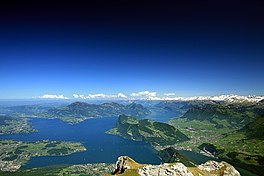 Вид на озеро Люцерн из пилатуса | |
 Озеро Люцерн | |
 map | |
| Location | Central Switzerland |
| Coordinates | 47°01′10″N 8°24′04″E / 47.0194°N 8.4011°E |
| Lake type | freshwater fjord, recent regulation[note 1] |
| Primary inflows | |
| Primary outflows | Reuss |
| Catchment area | 2,124 km2 (820 sq mi) |
| Basin countries | Switzerland |
| Max. length | 30 km (19 mi) |
| Max. width | 20 km (12 mi) |
| Surface area | 113.6 km2 (43.9 sq mi) |
| Average depth | 104 m (341 ft) |
| Max. depth | 214 m (702 ft) |
| Water volume | 11.8 km3 (2.8 cu mi) |
| Residence time | 3.4 years |
| Shore length1 | 143.7 km (89.3 mi) |
| Surface elevation | 434 m (1,424 ft) |
| Frozen | in the 17th and 19th century; Lucerne Bay and Lake Alpnach in 1929 and 1963 |
| Islands | Altstatt-Insel |
| Sections/sub-basins | |
| Settlements | |
| Website | http://www.lakelucerne.ch |
| References | [1] |
 | |
| 1 Shore length is not a well-defined measure. | |


Озеро Люцерн ( немецкий : vierwaldstättersee , буквально «озеро четырех лесных поселений » (на английском языке обычно переводится как лесные кантоны ), французский : lac des Quatre-cantons , итальянский : Лаго Дей Куаттро Кантони )-это озеро в центральной Швейцарии и четвертое крупнейший в стране.
География
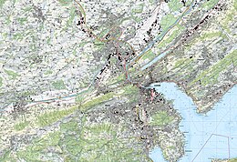
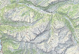
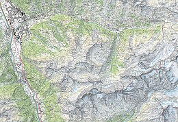
[ редактировать ]The lake has a complicated shape, with several sharp bends and four arms. It starts in the south–north bound Reuss Valley between steep cliffs above the Urnersee from Flüelen towards Brunnen to the north before it makes a sharp bend to the west where it continues into the Gersauer Becken. Here is also the deepest point of the lake with 214 m (702 ft). Even further west of it is the Buochser Bucht, but the lake sharply turns north again through the narrow opening between the Unter Nas (lower nose) of the Bürgenstock to the west and the Ober Nas (upper nose) of the Rigi to the east to reach the Vitznauer Bucht. In front of Vitznau below the Rigi the lake turns sharply west again to reach the center of a four-arm cross, called the Chrütztrichter (Cross Funnel). Here converge the Vitznauer Bucht with the Küssnachtersee from the north, the Luzernersee from the west, and the Horwer Bucht and the Stanser Trichter to the south, which is to be found right below the northeast side of the Pilatus and the west side of the Bürgenstock. At the very narrow pass between the east dropper of the Пилатус (называемый Лоппер ) и Стэнсстад. Озеро достигает своей юго -западной руки в Альпнахстаде на крутых южных предгорьях Пилатуса, Альпнахерси . Озеро стекает воду в режиму в Люцерне от его руки под названием Luzernersee (который буквально переводится как озеро Люцерно ).
The entire lake has a total area of 114 km2 (44 sq mi) at an elevation of 434 m (1,424 ft) a.s.l., and a maximum depth of 214 m (702 ft). Its volume is 11.8 km3. Much of the shoreline rises steeply into mountains up to 1,500 m above the lake, resulting in many picturesque views including those of the mountains Rigi and Pilatus.
The Reuss enters the lake at Flüelen, in the part called Urnersee (Lake of Uri, in the canton of Uri) and exits at Lucerne. The lake also receives the Muota at Brunnen, the Engelberger Aa at Buochs, and the Sarner Aa at Alpnachstad.
It is possible to circumnavigate the lake by train and road, though the railway route circumvents the lake even on the north side of the Rigi via Arth-Goldau. Since 1980, the A2 motorway leads through the Seelisberg Tunnel in order to reach the route to the Gotthard Pass in just half an hour in Altdorf, Uri right south of the beginning of the lake in Flüelen.
Steamers and other passenger boats ply between the different villages and towns on the lake. It is a popular tourist destination,[2] both for native Swiss and foreigners, and there are many hotels and resorts along the shores. In addition, the meadow of the Rütli, traditional site of the founding of the Swiss Confederation, is on the Urnersee shore. A 35 km commemorative walkway, the Swiss Path, was built around the Lake of Uri to celebrate the country's 700th anniversary in 1991.
Archaeologists surveying the lake-bed (during the construction of a pipeline) from 2019 to 2021 found the remains of a Bronze Age village with artifacts dating to around 1000 BC.[3] Later, the new findings indicated that the area was settled 2,000 years earlier than historians previously thought.[3]
Lake Lucerne borders on the three original Swiss cantons of Uri, Schwyz, and Unterwalden (which today is divided into the cantons of Obwalden and Nidwalden), as well as the canton of Lucerne, thus the name Vierwaldstättersee (lit.: Lake of the Four Forested Settlements). Many of the oldest communities of Switzerland are along the shore, including Küssnacht, Weggis, Vitznau, Gersau, Brunnen, Altdorf, Buochs, and Treib.

Lake Lucerne is singularly irregular and appears to lie in four different valleys, all related to the conformation of the adjoining mountains. The central portion of the lake lies in two parallel valleys whose direction is from west to east, the one lying north, the other south of the ridge of the Bürgenstock. These are connected through a narrow strait, scarcely one kilometre wide, between the two rocky promontories called respectively Unter Nas and Ober Nas (Lower and Upper Nose). It is not unlikely that the southern of these two divisions of the lake—called Buochser Bucht—formerly extended to the west over the isthmus whereon stands the town of Stans, thus forming an island of the Bürgenstock. The west end of the main branch of the lake, whence a comparatively shallow bay extends to the town of Lucerne, is intersected obliquely by a deep trench whose south-west end is occupied by the branch called Alpnachersee, while the north-east branch forms the long arm of Küssnacht, Küssnachtersee. These both lie in the direct line of a valley that stretches with scarcely a break in between the Uri Alps and the Emmental Alps. At the eastern end of the Gersauer Becken, where the containing walls of the lake-valley are directed from east to west, it is joined at an acute angle by the arm of Uri, or the Urnersee, lying in the northern prolongation of the deep cleft that gives a passage to the Reuss, between the Uri Alps and the Glarus Alps.[4][unreliable source]

The Urnersee occupies the northernmost and deep portion of the great cleft of the Reuss Valley, which has cut through the Alpine ranges from the St Gotthard Pass to the neighbourhood of Schwyz. From its eastern shore the mountains rise in almost bare walls of rock to a height of from 3,000 to 4,000 ft (910 to 1,220 m) above the water. The two highest summits are the Fronalpstock and the Rophaien (2078 m). Between them the steep glen or ravine of the Riemenstaldener Tal descends to Sisikon, the only village with Flüelen right on the shore on that side of the Urnersee. On the opposite or western shore, the mountains attain still greater dimensions. The Niederbauen Chulm is succeeded by the Oberbauenstock, and farther south, above the ridge of the Scharti, appear the snowy peaks of the Gitschen and the Uri Rotstock (2,928 m). In the centre opens the Reuss Valley, backed by the rugged summits of the Urner and Glarner Alps.[4]
The breadth of these various sections of the lake is very variable, but is usually between one and two miles (3 km). The lake's surface, whose mean height above the sea is 434 metres, is the lowest point of the cantons of Uri, Obwalden and Nidwalden. Originally the lake was susceptible to variations in level and flooding along its shoreline. Between 1859 and 1860, the introduction of a needle dam in the Reuss in the city of Lucerne, just upstream from the Spreuerbrücke, allowed the lake level to be stabilised.[1]
The culminating point of the lake's drainage basin, as well as Central Switzerland, is the Dammastock at 3,630 metres above sea level.[5]
Name
[edit]The name of Vierwaldstättersee is first used in the 16th century. Before the 16th century, the entire lake was known as Luzerner See "Lake Lucerne", as remains the English (and partly Italian, as Lago di Lucerna) usage.[1] The (three) "Waldstätte(n)" (lit.: "forested sites/settlements", in English usually translated as forest cantons[6]) since the 14th century were the confederate allies of Uri, Schwyz and Unterwalden. The notion of "Four Waldstätten" (Vier Waldstätten), with the addition of the canton of Lucerne, is first recorded in the 1450s, in an addition to the "Silver Book" of Egloff Etterlin of Lucerne.
The nine different parts of the lake have individual designations:[1][7]
- Urnersee ("Lake of Uri"): The first part of the lake, at the mouth of the Reuss between Flüelen and Brunnen.
- Gersauer Becken ("Basin of Gersau") next to Gersau below the Rigi massif is the deepest part of the lake.
- Buochser Bucht ("Bay of Buochs"): The bay of Bouchs, where the Engelberger Aa enters the lake.
- Vitznauer Bucht ("Bay of Vitznau"): The part between the Bürgenstock and Rigi.
- Alpnachersee ("Lake of Alpnach"): the almost separate, southern arm below the southern mountainside of Pilatus near Alpnach.
- Stanser Trichter ("Funnel of Stans"): The part north of the Pilatus, west of Bürgenstock, and in front of Hergiswil and Stansstad.
- Küssnachtersee ("Lake of Küssnacht"): The most northern arm, west of the Rigi with Küssnacht SZ at its northern end.
- Chrütztrichter ("Cross Funnel"): The meeting point of Stanser Trichter, Luzernersee, Küssnachtersee, and Vitznauer Bucht.
- Luzernersee ("Lake of Lucerne"): in German usage now limited to the bay at Lucerne as far as Meggenhorn, with its effluence of the Reuss.


Settlements
[edit]| Left shore[l 1] | Right shore |
|---|---|
|
|
| Luzern | |
Navigation
[edit]
The lake is navigable, and has formed an important part of Switzerland's transport system for many centuries, and at least since the opening of the first track across the Gotthard Pass in 1230. This trade grew with the opening of a new mail coach road across the pass in 1830. This road had its northern terminus at Flüelen at the extreme eastern end of the lake, and the lake provided the only practical onward link to Lucerne, and hence the cities of northern Switzerland and beyond.[8][9]
Whilst the development of Switzerland's road and rail networks has relieved the lake of much of its through traffic, it continues to be used by a considerable number of vessels, both private and public. Much of this usage is tourist or leisure oriented, but the lake continues to provide practical public and cargo transport links between the smaller lakeside communities.
Passenger boats of the Schifffahrtsgesellschaft des Vierwaldstättersees (SGV) provide services on the lake, including many run by historic paddle steamers. The SGV serves 32 places along the shore of the lake, with interchange to both main line and mountain railways at various points. Under separate management, the Autofähre Beckenried-Gersau provides a car ferry service between Beckenried, on the south bank of the lake, and Gersau on the north.
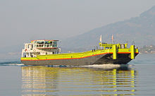
Cargo barges, to a local design known as Nauen, are still used on the lake. Some have been converted for use as party boats. Other barges are used by the gravel dredging industry that operates on the lake, using large dredgers to obtain sand and gravel for use in the construction industry.[10][11]
Cultural references
[edit]
Beethoven's Moonlight Sonata derives its name from an 1832 description of the first movement by poet and music critic Ludwig Rellstab, who compared it to moonlight shining upon Lake Lucerne.
Gioacchino Rossini uses this[clarification needed] in his William Tell Overture Section A: Sunrise over the Alps.
Rowing
[edit]Lake Lucerne has twice been used as a venue for the European Rowing Championships: in 1908 and then in 1926.[12][13] The nearby Rotsee has since 1933 been used for rowing regattas instead.
Tourism
[edit]
On the way south, the English discovered the mountains of central Switzerland. Several spa and bathing resorts such as Weggis or Gersau were created. In 1871, the very first rack railway in Europe, the Vitznau-Rigi Railway, was opened. In 1889 the steepest cog railway in the world was built from Alpnachstad to Mount Pilatus. Mark Twain described an ascent to the Rigi, which led to the blossoming of Swiss tourism in the United States in the 19th century. One of the largest steamship fleets in Europe operates with five steamships on Lake Lucerne.
In the area surrounding the lake and on terraces at medium height (for example Morschach and Seelisberg) there are numerous places for tourists. The Rigi, Pilatus, the Bürgenstock, the Stanserhorn, the Buochserhorn, and the two legends, the Urirotstock and the Fronalpstock are attractive panoramic mountains near Lake Lucerne. Most of them can be reached by mountain railways, some of which have their valley station near boat stations on the lake.
На озере есть многочисленные места, которые важны для швейцарской культурной и туристической истории: Рютли, Телсплатт, Часовня, Стэйс-Башня Стэнсстада, Ной-Хаббург, Шиллерштейн, Трейб, Астрид Часовня (Кюснахт) и Замок Меггенхорн.
Водные виды спорта
[ редактировать ]Различные виды спорта возможны в некоторых отдельных областях из -за воды и условий ветра. Озеро доступно от лодок и яхт, до озера курортов и бассейнов (например, бассейн Лидо в Люцерне, построенный в 1929 году Арнольдом Бергером). Следовательно, озеро может быть легко доступно с обоих берегов. Cee-Club Luzern был основан в 1881 году, который в настоящее время является крупнейшим в Швейцарском клубе гребля, а также в REUSS Luzern Rowing Club (Ruderclub Reuss Luzern) в 1904 году. Яхт-клуб Lucerne (Yachtclub Luzern) существует с 1941 года и работает яхт-клуб (Yachtclub Luzern) и работает и работает и работает и работает и работает и работает и работает и работает и работает и бегает яхт-клуб (Yachtclub Luzern). С 1966 года на Лучерне в Черчилль-Кваи в Люцерне.
Клуб водного спорта Бруннена (Wassersportclub Brunnen), основанный в 1958 году, проходил на озере Люцерн в первые годы своего существования международных гонок на моторных лодках и водных лыжных гонок. В 1965 году ассоциация выбрала новое название для клуба: Клуб водного спорта Lake Lucerne (Wassersport-Club Vierwaldstättersee). В 1980 году был основан Центральный швейцарный клуб моторных лодок (Motorbootclub Zentralschweiz), а в 1986 году в Клубе водного спорта Hergiswil (Wassersportclub Hergiswil). Schweizmobil создал тур на каноэ по озеру Люцерн между Брунненом и Герсау. Благодаря ветру в долине Рейс, южная часть озера Ури между кемпингом в Груонбахстранде во Флуелен и Айлентен, является центром виндсерфинга.
Дайвинг
[ редактировать ]Есть около десяти мест, где вы можете погрузиться без лодки на озере Люцерн. Вода довольно холодно круглый год и, следовательно, в основном очень ясна. На озере Ури, в Сисиконе, можно погрузиться в фрагментированную крутую вертикальную стену, на северном портале Schierneggtunnel. Lediwrack Bruno находится перед Брунненом на глубине 15 метров. Другие известные места для дайвинга находятся перед Вицнау, Вегисом, Герсау и Гергисвилом.
Погруженные боеприпасы
[ редактировать ]Швейцарские вооруженные силы исторически использовали озеро Люцерн в качестве свалки для старых боеприпасов, примерно 3300 тонн боеприпасов, в настоящее время погруженных в озеро. Швейцарское министерство обороны предложило приз в размере 50 000 франков (45 000 фунтов стерлингов) за лучшее предложение о безопасном удалении боеприпасов. [ 14 ]
Примечания и ссылки
[ редактировать ]Примечания
[ редактировать ]- ^ Вейр в Люцерне сохраняет уровень воды 2–3 м (6 футов 7 дюймов - 9 футов 10 дюймов) выше естественного среднего, см. Кантон Люцерна, Департамент трафика и инфраструктуры (2008): Die Regulierung des Vierwaldstädtersees - Der Ausbau Der Reusswehranlage в Luzern (PDF) Архивировал 14 мая 2014 года на машине Wayback
Ссылки
[ редактировать ]- ^ Jump up to: а беременный в дюймовый Ханс Стадлер: Vierwaldstättersee на немецком , французском и итальянском языке в онлайн -историческом словаре Швейцарии , 27 февраля 2013 года.
- ^ Заархивировано в Ghostarchive и на машине Wayback : Шв .
- ^ Jump up to: а беременный Дэвис-Маркс, Исида. «3000-летняя погруженная урегулирование обнаружено в Швейцарии» . Смитсоновский журнал . Получено 7 мая 2021 года .
- ^ Jump up to: а беременный Джон Болл , Альпийский гид, Центральные Альпы , с. 153, 1866, Лондон
- ^ 1: 25 000 топографическая карта (карта). Свисстопо . Получено 27 июля 2014 года .
- ^ Для перевода «Лесной кантон» см. EG Encyclopedia Britannica, 7 -е изд., Vol. 21 (1842), с. 44
- ^ «Озеро Люцерн: Более семи бассейнов ...» (PDF) . Наблюдатель (на немецком языке). Нет. 8/2011. Цюрих, Швейцария: наблюдатель . 7 октября 2011 года . Получено 7 октября 2016 года .
- ^ "Paddle Steamboat uri" (PDF) . Американское общество инженеров -механиков . 5 сентября 2008 года. Архивировано из оригинала (PDF) 3 сентября 2014 года . Получено 11 сентября 2012 года .
- ^ «Geschichte SGV» [история SGV] (на немецком языке). SGV . Получено 12 сентября 2012 года .
- ^ "Wabag Kies AG" (на немецком языке). Wabag Kies Ag . Получено 10 сентября 2012 года .
- ^ "Arnold & Co. AG" (на немецком языке). Arnold & Co. Ag . Получено 11 сентября 2012 года .
- ^ «Информация о событии» . Международная федерация гребли . Получено 30 июня 2018 года .
- ^ «Информация о событии» . Международная федерация гребли . Получено 30 июня 2018 года .
- ^ «Швейцария предлагает призовые деньги, чтобы вытащить боеприпасы из озер» . Би -би -си . Получено 31 августа 2024 года .
Внешние ссылки
[ редактировать ]- Waterlevels Laucerne Lucerne в Бруннен
- Waterlevels Lacerne Lucerne в Люцерне
- Озеро Люцерн Регион
- Nidwalden Tourism
- Кулидж, Уильям Август Бреворт (1911). . Encyclopædia Britannica . Тол. 17 (11 -е изд.). С. 97–98.
Озера Швейцарии |
|---|

- Озеро Люцерн
- Озера Швейцарии
- Озера Кантона Ури
- Озера Кантона Швиза
- Озера Обилдена
- Озера Нидволдена
- Озера Кантона Люцерна
- Рейс -бассейн
- Туристические достопримечательности в кантоне Ури
- Туристические достопримечательности в Нидволдене
- Nidwalden - Ури граница
- Nidwalden - obwalden граница
- Люцерна - нидволденская граница
- Люцерна - граница Швиса
- Шариз -ури граница
- Nidwalden - граница Schwyz