Столичный район Паддингтон

| Паддингтон | |
|---|---|
 | |
 Паддингтон в лондонском графстве | |
| Область | |
| • 1911 | 1356 акров (5,49 км 2 ) |
| • 1931 | 1,357 acres (5.49 km2) |
| • 1961 | 1,355 acres (5.48 km2) |
| Population | |
| • 1911 | 142,551 |
| • 1931 | 144,923 |
| • 1961 | 116,923 |
| Density | |
| • 1911 | 105 inhabitants per acre (260/ha) |
| • 1931 | 107 inhabitants per acre (260/ha) |
| • 1961 | 86 inhabitants per acre (210/ha) |
| History | |
| • Origin | Ancient parish |
| • Abolished | 1965 |
| • Succeeded by | City of Westminster |
| Status | Civil parish (until 1900) Metropolitan borough (1900–1965) |
| Government | Paddington Vestry (until 1900, reformed 1855) Paddington Borough Council (1900–1965) |
| • HQ | Paddington Town Hall, Harrow Road |
 Coat of arms of Paddington Borough Council | |
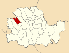
 Map of boundary Map of boundary | |
Паддингтон был гражданским приходом и столичным районом в Лондоне , Англия. Это был древний приход в графстве Мидлсекс , управляемый административным хранилищем . Приход был включен в область ответственности столичного совета по трудам в 1855 году и стал частью Лондонского графства в 1889 году. Приход Паддингтон стал столичным районом в 1900 году после 1899 года . заменен городским советом. В 1965 году район был отменен, а его бывший район стал частью города Вестминстер в Большом Лондоне.
История
[ редактировать ]
Its area covered that part of the current City of Westminster west of Edgware Road and Maida Vale, and north of Bayswater Road. Places in the borough included Paddington, Westbourne Green, Bayswater, Maida Hill, Queens Park, Kensal Green, West Kilburn, Maida Vale. To the south it bordered the Metropolitan Borough of Westminster, to the east, the Metropolitan Borough of St Marylebone.
The borough was abolished on 1 April 1965 by the London Government Act 1963 and its former area merged with that of the Metropolitan Borough of Westminster and the Metropolitan Borough of St Marylebone to form the present-day City of Westminster.
Borough council
[edit]Coat of arms
[edit]
The borough council's coat of arms, granted by the College of Arms on 5 April 1902, was based on the former Paddington vestry seal. The seal featured crossed swords from the arms of the See of London passing through a mural crown, symbol of local government. To these were added the wolves' heads and blue background from the arms of the first Mayor of the Borough, Sir John Aird.[1][2] Sir John, who was member of parliament for Paddington North, also donated the mayoral badge and chain.[3]
The arms were blazoned as follows:
Azure, two Swords in Saltire proper pommels and hilts Or enfiled with a Mural Crown of the last. Two Wolves heads erased in Chief Argent.[2][3]
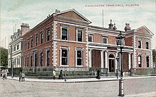
Town hall
[edit]Paddington Town Hall, designed by James Lockyer in the Classical style, dated from 1853.[4] The building, originally the Vestry Hall, was situated on Paddington Green. It was enlarged in 1900 and 1920. Following its closure in 1965, it was demolished to make way for the Westway urban motorway.[5]
Population and area
[edit]The area of Paddington Metropolitan Borough was 1,357 acres (5.5 km2), once part of Kensal New Town was added after 1901. The population recorded in the Census was:
Paddington Vestry 1801–1899
| Year[6] | 1801 | 1811 | 1821 | 1831 | 1841 | 1851 | 1861 | 1871 | 1881 | 1891 |
|---|---|---|---|---|---|---|---|---|---|---|
| Population | 1,881 | 4,609 | 6,476 | 14,540 | 25,173 | 46,305 | 75,784 | 96,813 | 107,058 | 117,846 |
Metropolitan Borough 1900–1961
| Year[7] | 1901 | 1911 | 1921 | 1931 | 1941 | 1951 | 1961 |
|---|---|---|---|---|---|---|---|
| Population | 143,976 | 142,551 | 144,261 | 144,923 | [8] | 125,463 | 116,923 |
- Note that the population statistics up to 1891 exclude the area of Kensal Town transferred from Chelsea in 1900.
Politics
[edit]Borough council
[edit]
Under the Metropolis Management Act 1855 any parish that exceeded 2,000 ratepayers was to be divided into wards; as such the incorporated vestry of Paddington was divided into four wards (electing vestrymen): No. 1 (12), No. 2 (18), No. 3 (18) and No. 4 (24).[9][10]
In 1894 as its population had increased the incorporated vestry was re-divided into six wards (electing vestrymen): Harrow Road (12), Maida Vale (9), Church (12), Westbourne (12), Lancaster Gate (15) and Hyde Park (12).[11][12]
The metropolitan borough was divided into eight wards for elections: Church, Harrow Road, Hyde Park, Lancaster Gate East, Lancaster Gate West, Maida Vale, Queen's Park and Westbourne.[13][14]
Parliament constituency
[edit]For elections to Parliament, the borough was divided into two and a half constituencies:
In 1918 the borough's representation was reduced to two seats:
See also
[edit]References
[edit]- ^ Scott-Giles, C Wilfrid (1953). Civic Heraldry of England and Wales, 2nd edition. London: J M Dent & Sons. p. 257.
- ^ Jump up to: a b Crossley, Richard (1928). London's Coats of Arms and the Stories They Tell. London: Robert Scott. pp. 162–164.
- ^ Jump up to: a b Beningfield, T J (1964). London 1900–1964. Armorial bearings and regalia of the London County Council, The Corporation of London and The Metropolitan Boroughs. London: Ed J Burrow & Co. Ltd. pp. 129–130.
- ^ Nikolaus Pevsner, The Buildings of England: London except the Cities of London and Westminster Harmondsworth 1952
- ^ "Commemorative Green Plaque for the site of the Paddington Town Hall, at the junction of Hermitage Street and Harrow Road, W2" (PDF). Westminster City Council. 21 June 2018. Retrieved 18 June 2021.
- ^ Statistical Abstract for London, 1901 (Vol. IV); Census tables for Metropolitan Borough of Paddington
- ^ Paddington MetB: Census Tables accessed 19 June 2007
- ^ The census was suspended for World War II''
- ^ The London Gazette Issue: 21802. 20 October 1855. pp. 3879–3881. Retrieved 8 April 2015.
- ^ «Отчет о пограничной комиссии HMSO за 1885 г. Карта Паддингтона» . Видение Британии . Получено 8 апреля 2015 года .
- ^ Выпуск Лондона Газета: 26526 . 26 июня 1894 г. с. 3671 . Получено 8 апреля 2015 года .
- ^ Выпуск Лондона Газета: 26548 . 4 сентября 1894 года. С. 5150–5152 . Получено 8 апреля 2015 года .
- ^ Почтовое отделение Лондонского округа Справочник, 1919 . 1919 . Получено 18 февраля 2015 года .
- ^ Обследование боеприпасов «Серия 3-го издания округа 3-е издание» Карта Лондона (1912-14) по шкале 1: 2500. Доступ на https://www.old-maps.co.uk/
Дальнейшее чтение
[ редактировать ]- Роберт Дональд , изд. (1907). «Лондон: Паддингтон» . Муниципальный год Книга Соединенного Королевства за 1907 год . Лондон: Эдвард Ллойд.
Районы местного самоуправления отменили или переданы Законом о правительстве Лондона 1963 года |
|---|

История формирования города Вестминстер |
|---|

- Столичные районы округа Лондон
- История города Вестминстер
- 1900 заведения в Великобритании
- 1965 г. в Соединенном Королевстве 1965 года
- Районы отменены в соответствии с Законом о правительстве Лондона 1963 года
- Приходы, управляемые Vestries (Metropolis)
- Паддингтон
- Бывшие гражданские приходы в городе Вестминстер