Форты Капри
| Форты Капри | |
|---|---|
| Анакапри , Кампания в Италии | |
 Плитка, установленная рядом с одним из четырех фортов | |
| Тип | Обогащение |
| Информация о сайте | |
| Состояние | Можно посетить с одноименной тропы |
| История сайта | |
| Материалы | Камень |
| Сражения/войны | Вторжение в Капри |
| События | Преобразование структур и следы в экомузеум |
Форты Капри , также называемые прибрежными фортами Анакапри [ 1 ] или бурбонские форты , [ 2 ] расположены в городе Анакапри , Кампания .
Структуры, построенные между 9 -м и 15 -м веками, первоначально использовались в качестве сторожевых баллов, поскольку CAPRI постоянно подвергался пиратским набегам. Уничтоженные сарацинскими пиратами, в начале 19 -го века эти древние военные конструкции были восстановлены британцами или французами, которые, хотя и в разных временных рамках, попали во владение острова в начале 19 -го века. В 2004 году форты стали экомуземом , с восстановлением структур и прикреплением плиток, описывающих их флору и фауну.
Сегодня можно легко добраться до фортов благодаря пути, который также соединяет голубую грот с маяком Пунта Карены . Растительность вдоль пути фортов является редкой, прерывистой и способной выжить в суровой среде, неоднократно поражая водяными брызгами. С другой стороны, не так много животных, которые обычно живут в редких лесах или в море.
Текстовые и графические источники
[ редактировать ]Форты Капри впервые упоминаются в документе в 1808 году, когда Пьетро Коллетта, сотрудник Бурбонского корпуса, опубликовал журнал «Завоевания Капри» . Коллетта в своей работе подробно описала последние битвы, которые Йоахим Мурат стал свидетелем из Масса Любренс. [ 3 ]
Форты впервые включены на карту в 1808 году, когда капитан Заннони собрал точную карту острова Капри, позже воспроизведенный в черно-белом в многочисленных книгах двадцатого века, чьи авторы предполагали, что это доказательства того, что форты были работой. британцев. Напротив, оригинальный цвет имеет следующую подпись внизу:
Короткие снимки, которые можно увидеть, отмеченные по периметру острова, как и на горе Соларо, - это винтовка, которая практикуется [ sic ] в этих сельских работах, построенных по случаю появления британского флота в Персидском заливе Неаполя, отличая то, что линии огня откуда откуда уходят эти выстрелы, если они все в красном цвете, они обозначают укрепления для продвижения британцев, а другие отмечены двумя параллельными линиями, - это мотивы, построенные французы.
The first historiographical account of the forts was written by Rosario Mangoni, who in his work Ricerche topografiche ed archeologiche sull'isola di Capri described their location, strategic function, wartime actions and users:
On the west coast of Anacapri three are built, the one called Pino to the north of the tip of Carena on a cape of the same name. Next to this along the same coast there is a second on another little cape called Campitello, and the last one is on the tip of Niglio called Batteria di Orico: a place still renowned because the French landed there in 1808 when they took this island. The forts are still well armed and suitable for the defense of this coast.
— Mangoni, p. 55
Mangoni published a second work in the same year, Ricerche storiche ed archeologiche sull'isola di Capri, in which he again mentioned the four military structures.[4] The French general and historian Mathieu Dumas (1753-1837) also mentioned the forts in a few pages of one of his essays, pointing out how hard it is to reach them.[5]
Thereafter, for centuries, the subject was no longer treated by historians; it was revisited only after World War II, when authors such as Umberto Broccoli[6] and Carlo de Nicola spoke about it.[7] Similarly, Roberto Ciuni reported the subject in some pages of his book La conquista di Capri;[8] other authors were Salvatore Borà, Romana de Angelis Bertolotti and Eduardo Federico.
In the 2000s the cultural association Oebalus wrote about it in the third volume of the collection Conoscere Capri. Here Borà, under the name of the association, described them "through the maps, cartographies and statements of people who witnessed the historical events that took place on the island between 1806 and 1808."[9] One of the most comprehensive textual sources concerning the forts was published in 2004, when the municipality of Anacapri distributed a paper document containing an accurate description of the forts and their naturalistic part, focusing on the flora and fauna of the path.[10]
History
[edit]
Middle Ages
[edit]Given its strategic location within the Gulf of Naples,[11][12] Capri was subjected to the constant raids of pirates for a long time. The phenomenon of piracy and privateering has characterized the island's history since the ninth century, when the privateering activities of the Saracens for the purpose of plundering the Mediterranean coast began.[10]
As the island was subjected to repeated attacks by Muslim corsairs, the decision was made to build more watchtowers along the eastern coast of Anacapri, in order to catch sight of corsair ships from afar and give timely warnings to the defenseless populations,[10] who then had the opportunity to take refuge in safer places (in this regard, the Barbarossa castle remains famous).[13]
However, the forts, like the other coastal towers and castles on the island, were destroyed at an unspecified age by the captains of the various barbarian powers, who during the retreat destroyed all the resources they were unable to take with them.[10]
Napoleonic era
[edit]When Napoleon took the city of Naples in 1806 from Ferdinand IV, who was again forced to flee to Sicily, he appointed his brother Joseph Bonaparte as king of Naples. The Neapolitan ruler shortly afterward sent a garrison to Capri to make it a French fortified base against England, which had settled on the island in May of that year.[11][14] On Oct. 3, 1808 Murat ordered General Jean Maximilien Lamarque to organize the fleet to be led to Capri.[15][16]
According to the archaeologist Umberto Broccoli, the expedition consisted of "sixty transports [...] escorted by the entire war flotilla, commanded by Giuseppe Correale and consisting of the frigate Ceres, commanded by Bausan, the corvette Fama, twenty-six gunboats and ten armed fishing boats. General Lamarque embarked on the Ceres with his staff, primarily General Pignatelli and Colletta. Then, according to Colletta's own instructions, Lamarque on the morning of October 5 gave orders to disembark in the Orico cove where with the help of ladders the soldiers managed to climb to Anacapri."[6]
Murat, meanwhile, went to Posillipo (Naples) to observe the landing operations; he moved during the final effort to Massa Lubrense, a town on the Sorrento peninsula, where he watched the last battles.[7]
After deceiving the Anglo-Saxon troops by pretending to target Marina Grande, Marina Piccola and Tragara, the French landed at Anacapri, which was poorly guarded as it was considered inaccessible from the sea. Lamarque's men, once landed near Orrico, hoisted themselves up a vertical slope overhanging the sea. Then, surprising the British, the French quickly captured Anacapri and the town of Capri below, which had previously been under siege.[15][16][17]
The British went to sign surrender pacts on October 16; the following day the Franco-Napolitans entered the island victoriously. During the so-called Invasion of Capri, the ruins of the forts were recovered and turned into short-firing artillery redoubts.[10][16]
It is still unclear, however, who precisely rebuilt the forts. The Anglo-Saxon forts, built to protect the emplacement from which the British armed forces were pulling, usually have massive walls and face the sea.[10] By contrast, forts facing the mountain, with thinner walls and equipped with loopholes and some covered rooms intended for the maintenance of foodstuffs, are generally attributed to the French.[10][16]
Contemporary age
[edit]
After the capture of Capri, the forts experienced a strong period of abandonment, having been neglected for almost all of the twentieth century despite their high historical and scenic value.[18] It was not until 1972, with the restoration project of the Orrico fort, that people began to think about a project that would include the restoration of all the existing forts along the west coast of Anacapri and the related paths. This project was taken up through interest by the municipal administration beginning in 1996, based on an organic design by architect Enrico Lucca. The municipality of Anacapri sponsored the work with the financial contribution of the European Union; work began in 1997 and ended in 2004.[19]
During the restoration work, designed and directed by architect Enrico Lucca, work was also carried out to "make all aspects of the area legible"; in fact, more than two hundred majolica tables were produced by ceramist Sergio Rubino,[20] now inserted along the path, describing its history, flora and fauna.[10] The botanical, historical and geological texts were made by Tullia Rizzotti; the faunal ones, on the other hand, were elaborated by Gennaro Aprea.[21]
The forts and the trail, after restoration work carried out in 2003, became the world's first open-air artistic-didactic ecomuseum.[10]
Description
[edit]Orrico Fort
[edit]
The Orrico fort opens on the tip of the Miglio, about thirty meters above sea level, and has a semicircular wall having a radius of ten meters and a thickness of two meters.[10][22][23]
The reconstruction of Orrico's fort is traditionally attributed to both the British and the French. In fact, the British placed two white stone blocks inside the fort, on which the cannons were placed,[22][23] and created a moat with loopholes for the riflemen in the back section of the building.[24][25] The French, on the other hand, built the fort's defense works upstream.[10]
Otherwise, the term "Orrico" does not possess a precise toponymy, but it is most likely to have a Hellenic origin, from the Greek word orrica meaning "flowering field."[24][26] In fact, in springtime, the dry meadows and rocky slopes in the area green up, giving a copious flowering of numerous tree species.[25][27]
Mesola Fort
[edit]
The Mesola fort opens on the Campetiello peninsula,[10] from which its second place-name originates, namely "Fort of Campetiello."[28] The second name of the promontory originates from the De Campetiello family, originally from Tramonti and owners of the area in 1129, when the island was still part of the Amalfi Republic.[25][29]
The Mesola fort was built in a strategic position, allowing the control of the entire coastal strip between Cala di Mezzo and Cala del Lupinaro.[10] The fortification has a rougher structure and a more massive curved wall, built to protect the firing position, the four upper rectangular compartments, symmetrical to the entrance, and a basement compartment where wounded soldiers were probably treated. The fort also has an outer perimeter moat facing upstream.[10]
The Mesola area, moreover, had probably been inhabited in prehistoric times; in fact, some obsidian tools and fragments of vases and other artifacts have been unearthed in the area.[30][31] Human presence in this impervious area was possible, according to Carl Friedlander, due to the existence of some drinking water rivulets that have now disappeared or become underground.[30]
In Greek and Roman times, however, there was a landfall in the area; the remains of a staircase carved into the rock can still be seen today.[30][32]
Pino Fort
[edit]
The Pino fort starts on the rugged cliffs of Cala di Mezzo and overlooks the Cala di Tombosiello,[33] forty meters above sea level.[30][34] The construction, larger in size than those of Orrico and Mesola, was built for the purpose of controlling a large portion of territory; in fact, it is suitable for guarding the Cala di Mezzo to the north and the Cala del Limmo to the south.[10]
The structure, attributed to the French, consists of two centrally located high rooms; one features a vaulted ceiling, while the other is covered by a flat wooden surface. A third room, later collapsed, was also present. The fort, also equipped with a cistern for water supply, was modified by the British, who added a firing square overlooking the sea.[10][30]
The location, moreover, constituted the end of a fortified wall that originated from the watchtower; nowadays this same wall, although still partly visible, has been cut off by the carriage road that connects the lighthouse with the center of the municipality.[33] The wall, about 180 meters long and equipped with loopholes for riflemen, closed the gap between the heights of the watchtower and the precipice of the Limmo Cove.[35] Finally, the wall was bordered by a trench into which enemies plunged, who were then impaled by sharp nails set into the rock.[35]
Cannon Fort
[edit]The Cannon Fort, not far from the Punta Carena lighthouse, opens onto the Tombosiello Cove, from which its second place-name "Tombosiello Fort" originates.[10] The building, erected by the British, has a conical shape and a radius of three meters; these small dimensions are due in part to the rugged nature of the area and in part to its proximity to other military structures, such as the Pino Fort or the Guard Tower.[10]
Naturalistic aspects
[edit]| Trail of the forts | |
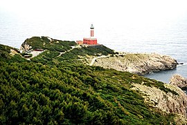 End of the trail at the Punta Carena lighthouse. | |
| Location | West coast of the island of Capri, Anacapri |
| Length | 5.2 km[10] |
| Beginning | Grotta Azzurra street, near villa Galatà |
| End | Via Nuova del Faro |
| Direction | North-South |
| Elevation gain | 120 m[10] |
| Walking time | 4–5 hours[10] |
| Difficulty | E[36] |
| Elevation map | |
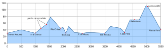 | |

The trail of the forts, usually divisible into three sections, connects the Punta Carena lighthouse with the Blue Grotto, passing through all four defensive structures edging the entire western coast of the island of Capri.
The vegetation along the route is sparse and discontinuous and consists mainly of dwarf shrubs that manage to survive in a hostile environment because they are continually wet by water spray. In fact, only plants capable of exploiting the rare soil accumulated between the rocks and the little moisture present in the cracks in the rocks take root. Among the many plants it is possible to identify species such as the wild fennel or the sea lavender.[37]
Behind this sparse and discontinuous vegetation begins a denser and more complex flora that fades into a shade of green typical of the Maquis shrubland. The latter does not reach three meters in height and is composed mainly of juniper, myrtle and mastic trees.[37] There are not many animal species in the area; most of them usually live in the sparse forests along the path or in the sea.[37]
From the Blue Grotto to Orrico
[edit]The trail begins at the height of villa l'Arcera and there are two panels with a concise general explanation.[10] The widening heads immediately close to the coast, away from the carriage road. At the beginning of the trail, where there are a few rare specimens of tassel hyacinth (once quite common), glides the woodcock, which was a victim of the hunting tradition that was strongly active in the area.[10]
Continuing on, the path is overlooked by the promontory of Damecuta, known for being the place where Tiberius built one of his twelve villas, from which kestrels and peregrine falcons can be seen flying. Otherwise the lane, beside which lentisk, myrtle and buckthorn grow, leads to a scenic lookout carved between low scrub and sheer cliffs. Around the latter there is a copious flowering of rue, spurge and asphodel; further on there is also Spanish broom.[10]
From the lookout point one can already catch a glimpse of Orrico's fort, which (as already mentioned) overlooks the tip of the Miglio. In the sea flowing near the building it is possible to see fin whales, sperm whales and dolphins; these species are sometimes on passage to the island when, from the Sorrento peninsula, they are headed to the island of Ischia.[10] Near the fort is a lay-by, the Largo Sculture del Vento, on which some species of birds, such as turtle doves, woodcocks and quails, brought to the area by the breeze, used to be hunted.[10]
After the Orrico Fort, the path runs along the edge of a forest of holm oaks, mastic trees and oleanders; wild asparagus grows prosperously in its shade. Continuing on, it is possible to reach the beach of the Goats, so called because it is not uncommon to find goats there.[10] After the shore, the trail, bending to the left, turns away from the sea and enters a wooded area.[10]
The wooded path towards Mesola
[edit]
The Fortini path, once past Goat Beach, enters a once cultivated wooded area where terraces supported by crumbling walls, hidden by wild vegetation, are still visible. Many songbirds stop in the area and carob, fennel and gladiolus thrive.[10]
Going further on, one encounters a small oak forest within which animal species linger: the great capricorn beetle, the rhinoceros beetle, the scops owl, the nightingale and the wood mouse.[10] At this point the path, flanking the fence wall of a villa, has specimens of Mediterranean buckthorn, myrtle and Phoenician juniper; the latter, of a resinous essence, gives its name to this portion of the itinerary, called the Street of the Old Junipers.[10]
Continuing on, the scrub thins out and it is possible to see the sea again. At this point on the trail one also glimpses a lobate-shaped pool forming part of the former Villa Rovelli, which opens onto an unnamed peninsula between the Lupinaro and Rio creeks.[10] A flight of living stone steps leads to a wider, rural road, often known as Via Passo della Capra or as Slargo dei Rosmarini e degli Asfodeli; asphodel, rosemary and rock campanula bloom copiously here. The trail is then concealed by a forest of Aleppo pines, extending close to the former Villa Rovelli, where a few hoopoe specimens can be encountered.[10]
The trail continues on to the so-called Acanthus Gorge, where the plant of the same name and the humbler tree species of arum and larus grow. In the next section, however, there is an ilex forest where in autumn there is a copious flowering of cyclamens.[10] Leaving the forest, one reaches the Agave Plot, where agave and scilla, a rare species in the Mediterranean basin but quite common on the island, are present. Helichrysum and sea fennel, which fights aridity by accumulating liquids through its succulent leaves, also grow among the cliffs; in addition, the bushes, to defend themselves from the wind (which is quite violent in this area), have generally taken on a domed habit flattened to the ground.[10]
Proceeding along the so-called path of the Wind, one arrives at the cove of Rio Latino, near which stands the Mesola fort. In this place, where Lotus cytisoides and marine static sprout and where there is a strong community of geckos and bats, there are the remains of a lime kiln, in which marble from Roman villas and ground limestone rock were melted. Rio Cove also includes a particularly fishy stretch of sea, where octopuses, groupers, moray eels, mullets, scorpion fishes and sea urchins breed.[10]
From Mesola to Pino
[edit]
The path then passes the Mesola fort and crosses a small thicket of anthyllis referred to as the "Flowering Moon"; the latter anticipates with its silvery reflections the landscape of the Campetiello peninsula, whose rock is corroded by karst, water and wind; in fact, this strip of land is very often compared to a "Flowering Moon."[10] Moving on, one encounters the rugged landscape of Mezzo Cove, otherwise known as the "Silver Fjord" for its beauty: it is a long fjord squeezed between rock walls on which numerous floral species such as cliff cornflower or gilly-flower sprout.[10]
Further along, the trail descends in elevation and reaches Tombosiello Cove, an area made up of gray limestone where the Phoenician juniper and the Maquis shrubland thrive.[10] The trail passes the Pino fort, detours past the Cannon fort and ends at a fork whose branches lead to the carriage road and the Faro pine forest, respectively.[10]
Initiatives
[edit]
The forts and the path are experiencing new uses that are quite unusual given their military purpose; these are being used to illustrate Capri's history, flora and fauna. Due to its considerable scenic and naturalistic value, the trail of the forts today is often involved in numerous guided hikes promoted by entities such as the Centro Caprense Ignazio Cerio and the Italian Alpine Club[36][38] or by smaller cultural associations.
These walks generally include numerous stops, which generally take place at the forts or at the Ruby Tiles, which, as already mentioned, contain accurate descriptions of the various floristic and animal species on the island. The Italian environmental association Legambiente has also organized a bicycle trip to the Orrico location.[39]
The Fortini Trail also occasionally hosts concerts at sunset by local singer-songwriter Almartino; it thus also becomes a venue for musical events.[28]
See also
[edit]References
[edit]- ^ Lucca, Enrico (28 August 2012). "Dalla grotta Azzurra all'eremo di Cetrella, un percorso lungo quarant'anni". Il Corriere di Capri.
- ^ "I Fortini Borbonici" (in Italian and English). Giovis.com.
- ^ Broccoli, pp. 326–328
- ^ Mangoni, pp. 425
- ^ Dumas, pp. 64–65
- ^ Jump up to: a b Broccoli, pp. 143–146
- ^ Jump up to: a b De Nicola, pp. 424–428
- ^ Ciuni, pp. 48–49
- ^ Oebalus, p. 9
- ^ Jump up to: a b c d e f g h i j k l m n o p q r s t u v w x y z aa ab ac ad ae af ag ah ai aj ak al am an ao ap Rizzotti, Tullia; Sica, Elio; Falessi, Antonio; Rubino, Sergio; Aprea, Gennaro (2004). Il Sentiero dei Fortini. Cartina con descrizione realizzata a cura della Regione Campania, dell'Assessorato dei Beni Culturali, del Comune di Anacapri e dell'isola di Capri.
- ^ Jump up to: a b Oebalus, p. 147
- ^ Federico, pp. 383–388
- ^ Borà 2002, p. 208
- ^ De Angelis Bertolotti, p. 34
- ^ Jump up to: a b Borà 2002, p. 249
- ^ Jump up to: a b c d Oebalus, pp. 149–152
- ^ Carratelli, Mimmo (2008). "La presa di Capri in due settimane". L'Isola. Archived from the original on May 30, 2012.
- ^ Rizzotti, p. 47
- ^ Progetti di restauro ambientale a cura del Ministero per i Beni e le Attività Culturali, Ufficio Centrale per i Beni Ambientali e Paesaggistici, Soprintendenza per i Beni Ambientali e Architettonici di Napoli e Provincia. Paparo Edizioni.
- ^ "Projects". La Bottega dell'Arte di Sergio Rubino. Sergio Rubino.
- ^ Anna Maria Boniello (16 November 2004). "Ad Anacapri il sentiero dei Fortini diventerà ecomuseo". Napoli: Il Mattino.
- ^ Jump up to: a b Borà 2002, p. 250
- ^ Jump up to: a b Oebalus, p. 157
- ^ Jump up to: a b Borà 2002, p. 251
- ^ Jump up to: a b c Oebalus, p. 158
- ^ Borà 1992, p. 123
- ^ Borà 1992, p. 122
- ^ Jump up to: a b Pulita, Nabil; Iraci, Susanna; Vivo, Salvatore; Almartino; Clemente, Lorenzo. I Fortini di Anacapri. Archived from the original on 21 August 2008. Retrieved August 30, 2008.
- ^ Borà 1992, p. 84
- ^ Jump up to: a b c d e Oebalus, p. 160
- ^ Federico, pp. 71, 77
- ^ "Фортини" . Capri.it.
Обнаружение прицельных башни Капри, следуя по пути между небесами и морем
- ^ Jump up to: а беременный Бора 2002 , с. 258
- ^ Бора 2002 , с. 260
- ^ Jump up to: а беременный Бора 2002 , с. 259
- ^ Jump up to: а беременный Война, Джованни (13 апреля 2008 г.). «Схема Fortini» . Итальянский альпийский клуб . Архивировано из оригинала 22 мая 2012 года . Получено 19 мая 2023 года .
- ^ Jump up to: а беременный в Oebalus , p. 162
- ^ «Тракинг Капри - Трагкая Э -Стория» (PDF ) Клуб Альмано Клуб. Архивировано из оригинала (PDF) 5 марта,
- ^ «Воскресенье Экологическая инициатива - остров на велосипеде с Legambiente» . Журнал Неаполя. 27 марта 2008 года. Архивировано из оригинала (TXT) 28 ноября 2012 года . Получено 11 ноября 2022 года .
Библиография
[ редактировать ]- Бора, Сальваторе (1992). Имена Капри. Происхождение и история дорог, шорт и окружение . Оболочка.
- Бора, Сальваторе (2002). Исторические и монументальные маршруты Капри и Анакапри . оболочка.
- Брокколи, Умберто (1963). Военные и морские хроники залива Неаполя и Понтин-Острова во время французского десятилетия (1806-15) . Министерство обороны.
- Ciuni, Roberto (1990). Завоевание Капри . Селтерио.
- Де Анжелис Бертолотти, Романа (июль 1990 г.). Капри. Природа и история . Занихелли.
- Де Никола, Карло; Риччи, Паоло (1963). Неаполитанский дневник: декабрь 1798 г.-декабрь 1800 года . Giordano Editore.
- Матье Дюма (1838). Кивнит на военные события или исторические очерки на сельской местности с 1799 по 1814 год . Литературно-типографическое учреждение университета.
- Федерико, Эдуардо; Миранда, Елена (1998). Древние Капри: От предыстории до конца римского эпоха . Оболочка.
- Мангони, Росарио (1834). Исторические исследования на острове Капри . Ладонь.
- Мангони, Росарио (1834). Топографические и археологические исследования на острове Капри . Баварская публичная библиотека.
- Oebalus. Познакомьтесь с Капри . Том 3.
- Rizzotti, Tullia (2003). Капри в цвету . Редакция Джорджио Мондадори.
- Капри . Bonechi Publishing House. 2002.
- Andrén, Arvid (1991). Капри. От палеолитического возраста до туристического возраста . Рим.
{{cite book}}: CS1 Maint: местоположение отсутствует издатель ( ссылка ) - Бонетто, Кристиан; Квинтеро, Жозефина (2010). Неаполь и побережье Амальфи . EDT. ISBN 978-88-6040-540-1 .
- Эдвин Церио (1983). Частная флора Капри. Обнаружение спонтанной растительности . Милан: Риццоли.