Джордж -Ривер (Квебек)

| Джордж -Ривер Джордж -Ривер | |
|---|---|
 | |
 Карта бассейна реки Джордж | |
| Location | |
| Country | Canada |
| Province | Quebec |
| Region | Nord-du-Québec |
| Physical characteristics | |
| Source | Lake Jannière |
| • location | Lac-Juilet Unorg. Territory, Caniapiscau RCM |
| • coordinates | 54°51′30″N 63°55′30″W / 54.85833°N 63.92500°W |
| • elevation | 488 m (1,601 ft) |
| Mouth | Ungava Bay |
• location | 18 km NW of Kangiqsualujjuaq, Kativik |
• coordinates | 58°49′00″N 66°10′00″W / 58.81667°N 66.16667°W |
• elevation | 0 m (0 ft) |
| Length | 565 km (351 mi)[1] |
| Basin size | 41,700 km2 (16,100 sq mi)[1] |
| Discharge | |
| • average | 940 m3/s (33,000 cu ft/s)[1] |
Джордж -Ривер ( Инуктитут : Кангирсуалууджуап Кунга , «Река Великого залива»; Наскапи : Мушуань корабль , «Река без деревьев»; Инну : Метшешу корабль , «Орлиная река»),), [ 2 ] ранее восток [ А ] или река Джорджа , [ 3 ] является рекой в северо -восточном Квебеке , Канада, которая течет из озера Янньер в основном на север до залива Унгава .
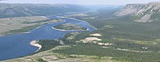
Джордж - большая и широкая река. Он предлагает относительно простой и недорогой доступ к заливу Унгава , по сравнению с другими основными реками этой области, что делает его популярным для походов на каноэ .
География
[ редактировать ]Река Джордж происходит около 175 километров (109 миль) к востоку от Шеффервиля в озере Джанньер, между болотами и болотами . Озера для головных водеров мелкие, соединенные стремительными порогами . После аванса на озере река проходит через тяжелую пока достигнет индийского дома не Уайтуотер, [ 4 ] который простирается 60 километров (37 миль), если измерено канадскими картами топо , или 100 километров (62 мили), если измерено его плоской характером.
After Indian House Lake, the George really starts to flow. It offers an abundance of rapids with various levels of difficulty until it reaches Kangiqsualujjuaq close to Ungava Bay. Because of its easy access, many people without the necessary experience and skills have travelled this river and unfortunately some lost their lives. The river is big and powerful. The power of the George leaves no room for error. Climatic conditions are ideal for hypothermia. Canoeists have to contend also with serious tidal effects in the last 40 kilometres (25 mi).
History
[edit]The George River received its present name on 12 August 1811, by two Moravian missionaries Benjamin Gottlieb Kohlmeister and George Kmoch.[5] These two missionaries came first to Okak in Labrador,[5] then to Ungava Bay with a vision to evangelize the Inuit. They wrote in their diary: "We then proclaimed the name of the Kangertlualuksoak to be henceforth George River, upon which every man fired his piece three times, the vollies being answered from the boat".[2][5][6] The Moravian brothers wanted to honour George III, king of Great Britain and Ireland from 1760, who, in 1769, granted the Moravians land on the Labrador coast for permanent settlement.[5]
John McLean, the factor of the Hudson's Bay Company outpost at Fort Chimo (present-day Kuujjuaq), established Fort Severight (present-day Kangiqsualujjuaq) at the mouth of the George in 1838.[7] The Inuit of the area never settled around the post, preferring to live along the coast in summer and setting their camps about 50 km (30 mi) inland in winter.
In June 1839, McLean took a party up the George in his search for a convenient overland route between Ungava Bay and Fort Smith (present-day North West River) on Lake Melville.[8] His predecessor Erland Erlandson had accidentally demonstrated its feasibility in 1834,[9] but along a more circuitous route up the Koksoak. Lacking Innu guides, McLean's expedition ended in failure with the discovery of the Grand Falls (now Churchill Falls) on the Hamilton (now the Churchill) and the party retraced its steps.[8] On the eastern shore of Erlandson's Lake (now Indian House Lake), they erected a post called Fort Trial in the winter of 1839–1840 to serve as a waystation and depot on the supply route they had established with Fort Nascopie on Petitsikapau Lake in the interior.[10] Fort Trial—also referenced in HBC correspondence as "Erlandson's Post"[11]—became superfluous with McLean's 1841 discovery of a route through a series of lakes around the falls and its rapids, after which the prosperous Fort Nascopie was supplied from Fort Smith instead. The HBC closed the entire unprofitable Ungava District soon after,[8] abandoning Fort Trial on 15 June 1842[12][13] and Fort Severight around the same time.
The old fort at the mouth of the river was reopened by the Hudson's Bay Company in September 1876, mostly to capture the local indigenous peoples' trade which had been going to the Moravians. The site abandoned again in the summer of 1878 before reopening again in 1883, after which it mostly served as a fishery for Fort Chimo until its closure in June 1952.[7]
The George River was also the site of the ill-fated Leonidas Hubbard expedition of 1903. The subsequent successful canoe expeditions of Mina Hubbard and Dillon Wallace in 1905 and Hesketh Prichard in 1910 also followed the George.
George River caribou herd (GRCH)
[edit]
The migratory George River caribou herd (GRCH), in the Ungava region of Quebec and Labrador in eastern Canada was once the world's largest herd with 800 000–900 000 animals. Although it is categorized as a subspecies Rangifer tarandus caribou,[14] the woodland caribou, the GRCH is migratory and like the barren-ground caribou its ecotype may be tundra caribou, Arctic, northern of migratory, not forest-dwelling and sedentary like most Woodland caribou ecotypes. It is unlike most woodland caribou in that it is not sedentary.
The dramatic decline in numbers of the George River herd has raised concerns.[15][16][b] In the 1980s there were between 700,000 and 800,000 in the herd caribou migrating between northern Quebec and Labrador. By 2010 there were 74,000. By 2012 the numbers dropped to 27,600 and by 2014 there were only 14,200.[17]
The "George River herd which morphologically and genetically belong to the woodland caribou subspecies, at one time represented the largest caribou herd in the world and migrating thousands of kilometers from boreal forest to open tundra, where most females calve within a three-week period. This behaviour is more like barren-ground caribou subspecies." They argued that "understanding ecotype in relation to existing ecological constraints and releases may be more important than the taxonomic relationships between populations."[18]
According to a National Geographic Daily News article, the George River Caribou Herd (GRCH) (Rivière-George) numbered only 3,500 animals in the late 1940s.[19] In 1958 the George River caribou herd was estimated to be numbered at 15,000. By 1988, it was the largest herd in the world with a population of 700,000.[20] And by 1993 the numbers rose to 775,000 animals.[19] By 2001, the herd was at 385,000 animals and continuing to decrease, totaling 75,000 animals in 2010.[21] The most recent survey puts the herd size at fewer than 28,000. The George River herd, south of Ungava Bay, whose numbers reached about 800 000 towards 1993, had about 384 000 individuals in 2001.[22]
In January 2013 the Innu, Inuit and Cree of Quebec and Nunatsiavut, NunatuKavut, and the Innu of Labrador formed the Ungava Peninsula Caribou Aboriginal Round Table[c] held emergency meetings and issued a joint statement.[23][15] in respond to the "critical decline" of the George River Caribou Herd (GRCH) and the "uncertain future" of the Leaf River Caribou Herd (LRCH) and Torngat Caribou Herds.[15]
The land is changing and the impacts of climate change, industrial development, and the growing human population and easier accessibility of the herd cannot be ignored in the management actions to be put forward. With the exponential rate of development, the protection of caribou habitat is greatly deficient and needs to be addressed seriously.
— Ungava Peninsula Caribou Aboriginal Round Table
[15] The Government of Nunatsiavut recommended that the "George River caribou calving grounds by designating a 14,000 km2 protection zone under the Regional Land Use Plan for the Labrador Inuit Settlement Area."
| year | population |
|---|---|
| late 1940s | 3,500[19] |
| 1958 | 15,000[19] |
| 1988 | 700,000[20] |
| mid-1990s | 750,000[22] |
| 2001 | 385,000[19] |
| 2011 | 74,000[16][24] |
| 2012 | 27,600[16] |
| 2014 | 14,200[17] |
Since the mid-1990s, the herd declined sharply and by 2010, it was reduced to 74,131—a drop of up to 92%.[25] A 2011 survey confirms a continuing decline of the George River migratory caribou herd population.[26] By 2014 the herd was estimated to be about to 14 200,[26] down from 27,600 in 2012, 74 131 in 2010 and 385 000 in 2001.[25][27][28]
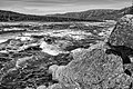
Image gallery
[edit]-
 August 2018
 -
 Helen's falls
 -
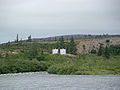 Abandoned US Army weather station on Indian House Lake
 -
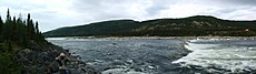
 George River
 -
 Ford Island


-
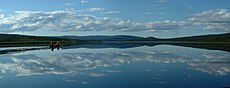 Indian House Lake
 -
 George River
 -
 Helen Falls
 -
 Сарвакаллак Рапид
 -
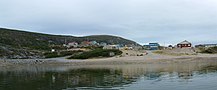 Kangiqsualujjuaq harbour в High Tide


Примечания
[ редактировать ]- ^ Отделение его от «Южной реки», бывшего названия Коксоака .
- ^ Закон о видах в отношении риска и окружающая среда Канада не включает стада Ungava Caribou в рамках стада бореальных карибу.
- ^ Инуиты Нунавика, инуита Нунациавута, Совета Общинного Совета Нунатукавута, нации Наскапи Кававахкамаха, Великого Совета Кресов Иистчи/Кри Региональной власти (GCCAI/CRA), инну Сообщества из региона Квебека.
Ссылки
[ редактировать ]Цитаты
[ редактировать ]- ^ Подпрыгнуть до: а беременный в Природные ресурсы Канада, Атлас Канады - Риверс Архивировал 4 апреля 2007 года на машине Wayback
- ^ Подпрыгнуть до: а беременный FQCK (2008). Руководство по канатным маршрутам Квебека, том II Броке. стр. 234–235. ISBN 978-2-89000-504-4 .
- ^ Бойл, Дэвид (1892), «Примечания о открывателе Великих водопадов Лабрадора» , Труды Канадского института , вып. II, Торонто: Copp, Clark Co, p. 337 .
- ^ Coady 2008 , p. 150
- ^ Подпрыгнуть до: а беременный в дюймовый Coady 2008 , с. 129–130 .
- ^ Kohlmeister & Knoch 1814 , SV "12 августа" .
- ^ Подпрыгнуть до: а беременный «Компания Hudson's Bay. Река Джорджа» , Архив Манитобы , правительство Манитобы .
- ^ Подпрыгнуть до: а беременный в Уэллс, Гаррон (1982), «Маклин, Джон (ум. 1890)» , Словарь канадской биографии , вып. XI, Университет Торонто/Университет Лаваль .
- ^ Джонсон, Алиса М. (1972), «Эрландсон, Эрланд» , Словарь канадской биографии , вып. X, Университет Торонто/Университет Лаваль , получен 30 января 2009 г.
- ^ Hart 2005 , p .
- ^ Coady 2008 , p. 154
- ^ «Архив компании Hudson's Bay» , Архив Манитобы , правительство Манитобы , извлечено 30 января 2009 года .
- ^ Coady 2008 , p. 161 .
- ^ Банфилд 1961 .
- ^ Подпрыгнуть до: а беременный в дюймовый Макивик 2013 .
- ^ Подпрыгнуть до: а беременный в Nunatsiaq News 2012 .
- ^ Подпрыгнуть до: а беременный CBC News 2014 .
- ^ Mallory & Hillis 1998 , p. 49
- ^ Подпрыгнуть до: а беременный в дюймовый и Уэллс 2013 .
- ^ Подпрыгнуть до: а беременный Bergerud, Luttich & Camps 2007 , p. [ страница необходима ] .
- ^ Джордж 2011 .
- ^ Подпрыгнуть до: а беременный Couturier et al. 2004 .
- ^ Макивик 2013a .
- ^ Survival International благотворительный фонд 2011 .
- ^ Подпрыгнуть до: а беременный Nunatsiaq News 2013 .
- ^ Подпрыгнуть до: а беременный «Правительство провинции предоставляет обновленную информацию о стаде Джордж -Ривер Карибу» , Департамент окружающей среды и сохранения , Ньюфаундленд, 14 августа 2014 года , извлечен 2 января 2015 г.
- ^ Варга, Питер (20 декабря 2013 г.), Потепление климата угрожает карибу в Нунавике, Лабрадор, Баффин: Исследование связывает выживаемость видов со стабильным климатом (PDF) , Институт арктической биологии, архивировано из оригинала (PDF) 15 января 2014 г. , полученные 14 января 2014 года
- ^ Ганн, Энн; Рассел, Дон (март 2013 г.), изменяя изобилие в миграционной тундре Карибу и диких оленя и роль в циркумполярной совместной сети (PDF) , информационной рассылке Deers Specialist Group (DSG), архивировав из оригинала (PDF) 18 января 2014 года , извлеченные 15 января 2014 года
Библиография
[ редактировать ]- Фрэнсис (1961 . Банфилд , Александр Уильям )
- Bergerud, Arthur T.; Luttich, Stuart N.; Camps, Lodewijk (декабрь 2007 г.), Возвращение Карибу в Унгаву , местный и северный сериал, McGill-Queen's, ISBN 9780773532335 , Получено 16 декабря 2013 г.
- «Население Джорджа -Ривер Карибу продолжает тревожно снизить: фотоуправление NL, биологи Квебека обнаружили 14 200 карибу, по сравнению с 27 600 в 2012 году» . CBC News . 15 августа 2014 года.
- Coady, Lawrence W. (2008). Потерянное каноэ: приключение Лабрадора . Нимбус. ISBN 978-1-55109-658-2 .
- Couturier, S.; Джин, Д.; Отто, Р.; Ривард С. (2004), Демография миграционной тундры Карибу (Рангифер Тарандус) из региона Норд-дю-Кебек и Лабрадора (PDF) , Квебек: Министерство природных ресурсов, дикой природы и парков, Квебек и Направление исследования дикой природы, Архивировано из оригинала (PDF) 20 декабря 2013 года
- Джордж, Джейн (25 мая 2011 г.), Nunavik Caribou Числа в быстром свободном падении: стадо Джордж-Ривер падает на 80 процентов , Нунавик, архивировав с оригинала 12 сентября 2017 года , извлеченные 17 декабря 2013 г.
{{citation}}: CS1 Maint: местоположение отсутствует издатель ( ссылка ) - Правительство Квебека, Министерство досуга, охоты и рыболовства (Департамент отдыха, рыбы и игры). 1985. Соображения, связанные с утоплением карибу реки Джордж на реке Каниапискау (сентябрь 1984 г.), Квебек -Сити: MLCP, XVI+100p. (+приложения).
- Правительство Квебека, Секретариат правительственной деятельности в обстановке америи и инуита (Sigmai). 1985. Карибу утонет на реке Каниапискау 28 и 29 сентября 1984 года, Квебек Сити: Сагмай, 14 п. (+приложения).
- Grubb, P. (2005). Уилсон, де ; Ридер, DM (ред.). Виды млекопитающих мира: таксономическая и географическая ссылка (3 -е изд.). Балтимор, доктор медицинских наук: издательство Университета Джона Хопкинса. ISBN 0-8018-8221-4 Полем OCLC 62265494 .
- Харт, Энн (2005), Роберта Бьюкенен; Брайан Грин (ред.), Женщина, которая наметила Лабрадор: Дневник жизни и экспедиции Мины Хаббард , Монреаль: Макгилл - Университетская издательство Университета, ISBN 978-0-77352924-3
- Колмейстер, Бенджамин Готтлиб; Knoch, George (1814), журнал путешествия из Оккака, на побережье Лабрадора, в залив Унгава, на западе Кейп Чадли, предназначенного для изучения побережья и посещения эскимоса в этом неизвестном регионе , Лондон: Общество братьев для дальнейшего Евангелия среди язычников
- -реки Джордж и реки Лиф: саммит аборигенов Карибу» , Кууджуак , Нунавик , 16–17 января 2013 «Лидеры аборигенов собираются вместе , г. , Макивик чтобы защитить стада карибу
- «Лидеры аборигенов Квебека и Лабрадорского подразделения для защиты Ungava Caribou» ,,, . апреля 2013 года, архивировав оригинала 2017 с kuujjuaq, Nunavik и Nain, Лабрадор, 24 года
- Мэллори, FF; Hillis, TL (1998), «Демографические характеристики циркумполярных популяций карибу: экотипы, экологические ограничения/выпуски и динамика населения» , Рангифер (Специальный выпуск 10): 9–60 , извлеченные 18 декабря 2013 г.
- «Размер Nunavik George River Caribou Stard Nosevives: New Survey» , Nunatsiaq News , 20 августа 2012 года, архивировано с оригинала 5 сентября 2015 года , полученная 15 декабря 2012 года.
- Квебеке и Лабрадор объединяют усилия, чтобы защитить Унгава Карибу» , Nunatsiaq , 26 апреля 2013 года, архивировано оригинала января из 15 «Инуиты, Инуу, Кри в
- Kangiqsualujjuaq , Nunavik Tourism, 2010, архивировав с оригинала 30 сентября 2017 года , извлечен 15 декабря 2013 г.
- Раси, GD; Армстронг, Т. (2000), «Занятость хребта леса в северо -западе Онтарио: прошлое и настоящее», Рангифер , 20 (специальный выпуск 12): 173–184, doi : 10.7557/2.20.5.1643
- Schaefer, JA (2003), «Долгосрочная рецессия диапазона и стойкость карибу в тайге», Biology , 17 (5): 1435–1439, doi : 10.1046/j.1523-1739.2003.02288.x , s2cid 56067931
- «Загадка рождественских оленей как крупнейшее в мире стадо резко падает» , Survival International Bariate Trust , 21 декабря 2011 года , извлечен 16 ноября 2012 г.
- Уэллс, Джефф (2 января 2013 г.), в упадке, Карибу сталкивается с жесткой зимой в Канаде , Национальном географическом обществе, архивировав с оригинала 6 января 2013 года , полученная 15 декабря 2013 г.