Пляж, Понсе, Пуэрто -Рико

Плайя | |
|---|---|
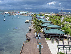 La Guancha Boardwalk , одна из достопримечательностей в Баррио Плайя | |
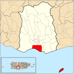 Location of barrio Playa within the municipality of Ponce shown in red | |
| Coordinates: 17°58′13″N 66°36′16″W / 17.970406°N 66.604442°W[1] | |
| Commonwealth | |
| Municipality | |
| Area | |
| • Total | 14.99 sq mi (38.8 km2) |
| • Land | 4.39 sq mi (11.4 km2) |
| • Water | 10.60 sq mi (27.5 km2) |
| Elevation | 0 ft (0 m) |
| Population (2010) | |
| • Total | 14,077 |
| • Density | 3,206.6/sq mi (1,238.1/km2) |
| Source: 2010 Census | |
| Time zone | UTC−4 (AST) |
Баррио Плайя , также известный как Плайя-де Понсе , Понсе Плайя , или Ла Плайя , является одним из тридцати одного баррио , которые составляют муниципалитет Понсе , Пуэрто-Рико . Наряду с Буканой , Канасом , Ваясом и Капитанехо , Плайя является одним из пяти прибрежных баррио муниципалитета. Barrio Playa также включает в себя несколько островов, крупнейшим из которых является Caja de Muertos . [ 3 ] Он был основан в 1831 году. [ 4 ]
Расположение
[ редактировать ]Плайя - это городской барио, расположенный в южном регионе муниципалитета, в пределах города Понсе, к югу от традиционного центра города в Плаза -Лас -Делицис , и на берегах Карибского моря . Он расположен на уровне 17,9839 ° с.ш. 66,6128 ° W, и он имеет высоту 10 футов. [ 5 ] Топонимия Карибскому , или происхождение названия, описывает географический район, который занимает Баррио в южном понде и лицом к морю . [ 6 ]
Boundaries
[ редактировать ]It is bounded on the North by PR-2, on the South by the Caribbean Sea, on the West by Río Matilde, and on the East by Río Bucaná.[7][8]
In terms of barrio-to-barrio boundaries, Playa is bounded in the North by Canas Urbano and San Anton, in the South by the Caribbean Sea, in the West by Canas, and in the East by Bucaná.[9]
Features and demographics
[edit]Unlike most other barrios of Ponce, Playa's landscape is entirely flat. Playa also has the second longest coastline of all five of Ponce's coastal barrios, after Canas. Playa has 4.6 square miles (12 km2) of land area and no water area.[10]
In 2000, the population of Playa was 4,761 persons, and it had a density of 1,031 persons per square mile.[10] The communities of Villa del Carmen, Valle Real, Villa Tabaiba, Salistral, El Caribe, Puerto Viejo, Los Meros, Amalia Marin, Lirios del Sur, and Playa proper are found here.[8][11]
In 2010, the population of Playa was 14,077 persons, and it had a density of 3,206.6 persons per square mile.[12]
This barrio, or ward, has its own plaza giving it the character of a municipality within a municipality. It has a residential area, a tourist area called La Guancha, and a harbor, Puerto de Ponce.
Playa has the second longest coastline of all five coastal barrios in Ponce, after Canas.[13]
| Census | Pop. | Note | %± |
|---|---|---|---|
| 1900 | 4,660 | — | |
| 1910 | 5,181 | 11.2% | |
| 1920 | 4,717 | −9.0% | |
| 1930 | 6,172 | 30.8% | |
| 1940 | 5,608 | −9.1% | |
| 1950 | 12,472 | 122.4% | |
| 1970 | 15,574 | — | |
| 1980 | 20,253 | 30.0% | |
| 1990 | 18,027 | −11.0% | |
| 2000 | 16,926 | −6.1% | |
| 2010 | 14,077 | −16.8% | |
| U.S. Decennial Census 1899 (shown as 1900)[14] 1910-1930[15] 1930-1950[16] 1960[17] 1980-2000[18] 2010[19] | |||
Infrastructure
[edit]Major roads serving Barrio Playa are PR-52, PR-2, PR-12, PR-123, and PR-585.[20]
History
[edit]
As the major means of external communication for the settlement that was to become the city of Ponce, barrio Playa has a history that is as old as the history of the city of Ponce itself, thus dating back to the 16th century. During the 16th century, barrio Playa was called Montones.[21] Subsequently, during the 17th and 18th centuries, significant contraband took place on these shores as well as attempts to attack and ransack the Playa settlement. A lookout post was set up in El Vigia to warn the city of the need of help in the Playa harbor, a port settlement at the time.
By the 1830s, la Playa had one of the best roads in Puerto Rico, connecting the shore settlement to the city proper, and it was the center of Ponce's commercial activity. It subsequently also got the first phone lines in Ponce and was also the first one to get railroad service from downtown Ponce.[22]
Unfortunately, in 1845 a significant fire occurred in La Playa.[23] The fire destroyed Playa and most of the Ponce vicinity. It significantly damaged the Spanish Customs House in Ponce, this being one of the few building left standing after the fire.[24] The fire burned down the major buildings of the "Marina de Ponce".[23] This moved Puerto Rico governor Conde de Marisol to create a new voluntary fire-fighting organization island-wide.[citation needed]
In 1887 the Spanish government built a lighthouse at Caja de Muertos Light on an island by the same name just off the coast of barrio Playa.[25] This was followed by the building of Cayo Cardona lighthouse in 1889, on a small island at the entrance of the Ponce harbor.[26] Both of these islands are part of barrio Playa.
By 1913, Playa was "a dynamic neighborhood with a self-sustained urban development with a population of 5,169 distributed through a residential area dominated by wooden houses, sugar cane farms, churches, schools, hospitals, a cemetery and local indiustries that promoted the formation of a strong artisan and industrial workers class."[22] Playa is considered Puerto Rico's first planned suburban area.[27]
In 1929, La Playa was the place where Dr. Manuel de la Pila Iglesias worked for the U.S. federal government with such distinction as to earn him the title "physician of physicians."[28]
Today, Playa is a mostly low-income barrio of Ponce, and thus this is where Isolina Ferré founded her "Centro de Orientacion de la Playa" hospital and school that would earn her the U.S. Presidential Medal of Freedom in 1999. The Ponce Playa Diagnostic and Treatment Center was also founded in barrio Playa de Ponce.[citation needed]
Landmarks
[edit]
Playa is home to a mix of Ponce and Puerto Rico landmarks: Puerto Rico Iron Works foundry, Plaza del Caribe mall, Club Náutico de Ponce yacht club, La Guancha boardwalk, and Caja de Muertos natural reserve are all located in Barrio Playa. The historic Cardona Island Light, Caja de Muertos Lighthouse, United States Custom House and McCabe Memorial Church,[29] all National Register of Historic Places listed landmarks, are also located in Barrio Playa. Playa also has the most important Caribbean seaport in Puerto Rico, called Port of the Americas.[30]
Notable natives and residents
[edit]People from La Playa are called "playeros".
- Rafael Cordero Santiago, mayor of Ponce (1988–2004)[31]
- Javier Culson, Olympic medal winner track-and-field athlete[32]
- Carmen Nydia Velázquez, comedian and singer[33]
- Jaime L. Drew, educator, writer, civil servant and engineer[34]
- José "Chegüi" Torres, professional boxer[citation needed]
- Carmen Nydia Velázquez, actress and singer[35]
Gallery
[edit]-
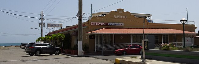
 Sea food restaurant facing the Caribbean Sea on Calle Alfonso XII
 -
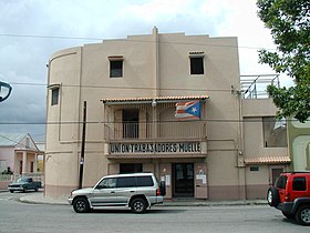 Dockworkers' union building in Playa
 -
 Seafood restaurant at Club Nautico de Ponce
 -
 International food restaurant at Club Nautico de Ponce
 -
 Interior of International food Cafe Lucero restaurant
 -
 International food restaurant Cafe Lucero on Calle Salmon and Calle Ramon R. Velez
 -
 Puerto Rican and sea food restaurant on Avenida Hostos
 -
 Sea-front Puerto Rican and sea food restaurant at historic train depot on Avenida Hostos Final
 -
 Italian restaurant on the campus of Plaza del Caribe mall
 -
 Chinese restaurant on the campus of Plaza del Caribe mall


See also
[edit]References
[edit]- ^ Jump up to: a b "US Gazetteer 2019". US Census. US Government.
- ^ U.S. Geological Survey Geographic Names Information System: Playa barrio
- ^ Map of Ponce Municipio, Puerto Rico. United States Geological Survey. Home Town Locator. Retrieved 6 June 2011.
- ^ Barrios de Ponce. Archived 30 September 2015 at the Wayback Machine Antepasados Esclavos.(From: Pedro Tomás de Córdoba. Memorias geográficas, históricas, económicas y estadísticas de la Isla de Puerto Rico.) Retrieved 28 November 2014.
- ^ U.S. Geological Survey. Topographic Map of Ponce. Map Styles: Map and Shaded. Trails.com. From: USGS. Topo Map. Projection: NAD83/WGS84. Coordinates and Elevation of Barrio Playa. Retrieved 25 February 2010.
- ^ Government of the Municipality of Ponce. Periodico "El Señorial". Special issue: Carnaval Ponceño 2013. February 2013. Page 17. Ponce, Puerto Rico.
- ^ Government of the Commonwealth of Puerto Rico. General Purpose Population Data, Census 2000. Unidad de Sistemas de Información Geográfica, Área de Tecnología de Información Gubernamental, Oficina de Gerencia y Presupuesto. Gobierno de Puerto Rico. Archived 2010-08-12 at the Wayback Machine Retrieved 24 February 2010.
- ^ Подпрыгнуть до: а беременный Геологическая служба США. Топографическая карта Понсе. Карта стили: карта и затененная. Trails.com. От: usgs. Карта топо. Проекция: NAD83/WGS84. Получено 25 февраля 2010 года.
- ^ Веб -арецибо. Понсе, Пуэрто -Рико: Барриос. Получено 25 февраля 2010 года.
- ^ Подпрыгнуть до: а беременный Бюро переписей США. Перепись 2000. Понсе и его Барриос. единицы, площадь и плотность: 2000. Набор данных: перепись 2000 Свод (Municipio, Ponce, Пуэрто-Рико-подразделение и место округа. GCT-PH1. Население, жилищные . Archive.Today Получено 25 февраля 2010 года.
- ^ Автономный муниципалитет Понсе. Управление по планированию территориальной. (Муниципальный муниципалитет Понсе. Получено 20 февраля
- ^ Пуэрто -Рико: 2010: количество населения и жилищного подразделения. PDF (PDF) . Департамент торговли, экономики и статистики США, Бюро переписей США. 2010 год.
- ^ Факт -искатель. Перепись США 2000 Архивировано 12 февраля 2020 года в Archive.Today Получено 21 февраля 2010 года.
- ^ «Отчет о переписи Порту -Рико 1899 года» . Директор офиса военного департамента Перепись Порту -Рико. Архивировано из оригинала 16 июля 2017 года . Получено 21 сентября 2017 года .
- ^ «Таблица 3 Популяция муниципалитетов: 1930 1920 и 1910» (PDF) . Бюро переписи Соединенных Штатов. Архивировано (PDF) из оригинала 17 августа 2017 года . Получено 21 сентября 2017 года .
- ^ «Таблица 4 и население муниципалитетов Городской и сельской местности: с 1930 по 1950 год» (PDF) . Бюро переписи Соединенных Штатов. Архивировано (PDF) из оригинала 30 августа 2015 года . Получено 21 сентября 2014 года .
- ^ Перепись населения, 1960: количество жителей, характеристики населения, общие социальные и экономические характеристики и подробные характеристики. Характеристики населения . США Бюро переписи. 1963. С. 97–101 . Получено 10 июня 2023 года .
- ^ «Таблица 2 Население и жилищные единицы: 1960–2000» (PDF) . Бюро переписи Соединенных Штатов. Архивировано (PDF) из оригинала 24 июля 2017 года . Получено 21 сентября 2017 года .
- ^ Пуэрто -Рико: 2010 год населения и жилищного подразделения. PDF (PDF) . Американское отделение торговли экономики и статистики Администрации США Бюро переписей. 2010. Архивировал (PDF) из оригинала 20 февраля 2017 года . Получено 2 августа 2019 года .
- ^ Данные об общем назначении населения, перепись 2000. Географические информационные системы, Государственные информационные технологии, Управление и бюджетное управление. Правительство Пуэрто -Рико. Ап- 2010-08-12 на машине Wayback получил 26 февраля 2010 года.
- ^ Эли Д. Окендо-Родригес. Pablo L. Crespo-Vargas, редактор. На берегах Карибского моря: исторический набросок пляжа Понсе - от его первых жителей до начала 20 -го века. Первое издание. Июнь 2017 года. Редакция Акеларре. Центр исследований и исследований с юго -запада от Пуэрто -Рико (Ceisco). Ладжас, Пуэрто -Рико. Страница 21. ISBN 978-1547284931
- ^ Подпрыгнуть до: а беременный Аида Белен Ривера Руис, сертифицирующий чиновник, и Хуан Лланс Сантос, препарат, Пуэрто -Рико. (Сан-Хуан, Пуэрто-Рико) 26 февраля 2008 года. В Национальном реестре исторических мест в форме инвентаризации-Мемориальная церковь МакКейба . Министерство внутренних дел Соединенных Штатов. Служба национальных парков. (Вашингтон, округ Колумбия) Раздел 8. Стр. 15. Список ссылок № 80000283. Опубликовано 11 апреля 2008 года.
- ^ Подпрыгнуть до: а беременный Истинная и подлинная история города Понсе. Доктор Эдуардо Нейманн. 1913. (на испанском) воспроизведено Институтом Пуэрториканской культуры (1987) Стр. 194.
- ^ Джеймс С. Масси, исполнитель. Вице -президент, и Ширли Максвелл, партнер, Национальный институт сохранения (Национальный музей здания) Вашингтон, округ Колумбия и Федеральное управление исторического сохранения, Министерство казначейства США. (Вашингтон, округ Колумбия) 7 января 1988 года. В Национальном реестре исторических мест регистрационная форма - US Custom House, Ponce . Министерство внутренних дел Соединенных Штатов. Служба национальных парков. (Вашингтон, округ Колумбия) Раздел 8, стр. 3. Список ссылок № 88000073. 10 февраля 1988 года.
- ^ Национальный реестр исторических мест Форма инвентаризации-Исла Каджа де Муэртос Свет . Министерство внутренних дел Соединенных Штатов. Служба национальных парков. (Вашингтон, округ Колумбия).
- ^ Национальный реестр исторических мест Форма инвентаризации-Cayo Cardona Light . Министерство внутренних дел Соединенных Штатов. Служба национальных парков. (Вашингтон, округ Колумбия).
- ^ Диана Лопес Сотомайор. Муниципальное здание La Playa de Ponce. Национальный реестр исторических мест. Регистрационная форма.
- ^ Доктор Мануэль де ла Пила Иглесиас: прославленный доктор Понсе и Пуэрто -Рико. Норман Мальдонадо, Md. Гален: журнал для Пуэрто -Рико. Том 9. Год 2. № 2. (Март - апрель 2009 г.) Гуайнабо, Пуэрто -Рико: MW World PR Corp. Доступ 28 апреля 2018 года.
- ^ Мемориальная церковь МакКейба расположена в Баррио Плайя, полученная 3 декабря 2009 года.
- ^ Новый переходный центр в Пуэрто -Рико. Архивированный 2013-09-21 на машине Wayback Ричард Уэстлунд. Латинская торговля. 1 июня 2009 года. Получено 19 сентября 2013 года.
- ^ Закон № 256. HB 2988; Закон № 256, утвержден 13 августа 2008 года. Закон: направить общественную структуру и комиссию по именованию шоссе Института Пуэрториканской культуры, чтобы назвать Road PR-9 (Beltway) Понсе после Рафаэля (Чурумба) Кордеро-Сантиаго. Законодательное собрание Пуэрто -Рико. Сан -Хуан, Пуэрто -Рико. 13 августа 2008 года. Получено 27 апреля 2013 года.
- ^ Приветствую гордую бабушку. Джейсон Родригес Графал. (Название в печатной версии: от Ponce Beach: гордая бабушка приветствует на расстоянии. ) Южная жемчужина. Понсе, Пуэрто -Рико. 1 августа 2012 года. Год 30. Номер 1496. Страница 6. Получено 1 августа 2012 года.
- ^ Они парада в мессе, чтобы почтить память. Сандра Торрес Гусман. Южная жемчужина. Понсе, Пуэрто -Рико. Год 31. Выпуск 1556. 25 сентября 2013 г. Страница 24. Получено 25 сентября 2013 года.
- ^ Луис Фортуньо Джаниро. «Исторический альбом Понсе (1692-1963)». Страница 246. (Imprenta Fortuño. Ponce, Puerto Rico. 1963.)
- ^ Счастливая Кармен Нидия Веласкес с признанием на ее пляже в Понсе. Южные голоса. Понсе, Пуэрто -Рико. 15 января 2020 года. Доступ к семенам 16 января 2020 года.
Внешние ссылки
[ редактировать ] СМИ, связанные с Playa (Ponce) в Wikimedia Commons
