Сан Луис Потоси (город)
Сан Луис Потоси | |
|---|---|
Город | |
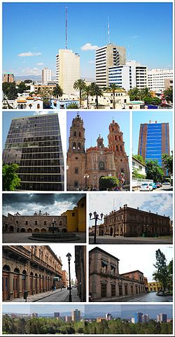 Слева направо и сверху вниз: здания в Авениде Карранса, Секретариат Башни иностранных дел, Св. Иоанна Крестителя. Собор Луи , Национальный институт статистики и башни Геграфи, Плаза де Сан -Франциско, Музейный национальный де -ла -маскара , Университет Калле, Исторический центр Сан -Луис Потоси, Панорама Сан -Луиси | |
| Прозвище (ы): Город садов ( Город садов ) | |
 Сан Луис Потоси Расположение Сан -Луис Потоси в Мексике | |
| Координаты: 22 ° 9′4 ″ N 100 ° 58′34 ″ W / 22,15111 ° N 100,97611 ° W | |
| Страна | |
| Состояние | |
| Основан | 3 ноября 1592 года |
| Основано как | Pueblo de san luis mesquiquique |
| Правительство | |
| • мэр | Энрике Франциско Галиндо Селлас |
| Area | |
| • Municipality | 385 km2 (149 sq mi) |
| Elevation | 1,864 m (6,115 ft) |
| Population (2015) | |
| • Municipality | 824,229[1] |
| • Metro | 1,221,526[1] |
| • Demonym | Potosino (a) |
| GDP (PPP, constant 2015 values) | |
| • Year | 2023 |
| • Total | $35.8 billion[2] |
| • Per capita | $28,300 |
| Time zone | UTC−6 (CST) |
| • Summer (DST) | UTC−5 (CDT) |
| Website | ayuntamientoslp.gob.mx |


Сан -Луис Потоси , обычно называемый Сан -Луисом , или его инициалами SLP ( Otomi : Nmiñ'u ), является столицей и самым густонаселенным городом мексиканского штата Сан -Луис Потоси . Это муниципальное место окружающего муниципалитета Сан -Луис Потоси. Город находится на высоте 1864 метра (6115 футов). оценкам, население 824 229 в самом городе и население приблизительно 1221 526 в его столичном районе, сформированном с соседним городом Санчес муниципалите Соледад -де -Грациано и другие окружающие По в Мексике .
Город находится в западной части штата Сан-Луис Потоси , на 22,16 ° с.ш., 100,98 ° с. Муниципалитет имеет площадь 1443,14 квадратных километров (557,20 квадратных миль). Это макрорегиона Баджио . часть [ 3 ] [ 4 ] [ 5 ]
Город назван в честь Луи IX из Франции (также известного в Мексике как Сан -Луис Рей де Франция города , Сент -Луис, король Франции), который является покровителем . Потоси был добавлен со ссылкой на сказочно богатые шахты Потосии , Боливия , обнаружила, что за сорок лет до того, как город был основан, поскольку эксплуатация серебряных и золотых рудников в Серро -де -Сан -Педро , недалеко от Сан -Луиса, была главной причиной основания города в 1592 году. [ 6 ]
В настоящее время город является одним из основных промышленных центров в центральной части Мексики с плодовитой производственной промышленностью. Ряд иностранных отраслей решил инвестировать в Сан -Луис Потоси в последние десятилетия благодаря его стратегическому расположению торговли, поскольку город расположен на полпути между Мехико и границей Соединенных Штатов, а также в середине сформированного треугольника Три крупнейших города в Мексике: Мехико, Гвадалахара и Монтеррей . [ 7 ]
Помимо своей промышленной экономики, недавно город был повышен в качестве туристического направления в центральной части Мексики в результате государственных и федеральных программ. Исторический центр Сан -Луис Потоси демонстрирует замечательную смесь различных художественных стилей во многих зданиях и является основным примером колониальной архитектуры в Мексике. В 2010 году исторический центр был указан в качестве сайта всемирного наследия ЮНЕСКО в рамках Камино Реал де Тьерра Адентро . [ 8 ]
История
[ редактировать ]Предоколониальный период
[ редактировать ]In pre-Hispanic times, the territory now occupied by the state of San Luis Potosí included two cultural areas: Mesoamerica and Aridoamerica. While the southern and eastern regions of the state were occupied by Otomi and Huastec kingdoms, its northern and central-west regions, where the city of San Luis now is located, were inhabited by Chichimeca. Chichimeca is a generic term given to various nomadic ethnicities which inhabited the northern fringes of the Aztec Empire, which is now northern Mexico. As they were nomadic peoples, they did not build large cities nor have permanent settlements like most Mesoamerican civilizations. They are described by historians as very warlike peoples, living in continual wars among themselves. These tribes spoke different languages but their customs were similar.[9]
After the arrival of Spanish conquistadores and their indigenous allies into the territory now formed by the Mexican nation, it still took them about a century to colonize the northern territories in Aridoamerica. When the settlers founded the first settlements in the region in late 16th century, they had to struggle against constant attacks from Guachichil tribes. Extremely belligerent, these tribes attacked traders who traveled to Zacatecas in newly created routes. Conquistadores and religious missionaries called the place where San Luis now is located "El Gran Tunal" (Grand Place of Tuna fruit). Finally, in 1589, peace between Chichimeca peoples and Spanish settlers was reached thanks to efforts made by Miguel Caldera and Brother Diego de la Magdalena, which marked the end of the Chichimeca War.[9][10]

Colonial period
[edit]A Franciscan mission was established in the zone in 1583, nine years before the city's founding. In early 1592 the mines of Cerro de San Pedro were discovered. The lack of water in Cerro de San Pedro made impossible a new settlement in that specific area, as well as the proper exploitation of the minerals. A short distance away there was a valley where water was abundant. This originated the creation of a new township to facilitate the labors of mining extraction. The legal foundation of the town of San Luis Potosí was made in November 3, 1592, according to a charter commission raised by Viceroy Luís de Velasco and given to Miguel Caldera (considered the historic founder of the city) and Juan de Oñate.[11]
Independence
[edit]For a time in 1863, during the French invasion of Mexico, San Luis Potosí served as the capital of the republican government, under President Benito Juárez.

The Plan of San Luis Potosí, issued November 20, 1910, was the opening shot of Mexico's revolution against the dictator Porfirio Díaz. The 1910 presidential election was stolen when Díaz had his opponent Francisco I. Madero arrested and imprisoned. Madero fled and issued the Plan of San Luis Potosí, declaring the election void and calling upon Mexicans to take up arms against the government.
Today, the downtown is one of plazas and colonial architecture. The "Plaza de Armas" is the site of a cathedral and governor's palace (1770). The nearby "Templo de Nuestra Señora del Carmen," with its colorful tiled domes and famous altars, is considered among Mexico's finest churches. In addition, San Luis is home to the bullring Plaza de Toros Fermin Rivera.
Outside the center, a modern industrial city has begun to grow.
The Universidad Autónoma de San Luis Potosí (UASLP) is in the city. Based on a Jesuit College founded in 1624, the Instituto Científico y Literario was raised to the category of a university in 1923, and is recognized as one of Latin America's best universities.
Today
[edit]With a population of approximately one million inhabitants, it is now the twelfth largest metropolitan area in Mexico. The city is a major commercial and industrial center. It lies in an economically advantageous area at the heart of the "triangle" formed by the three largest cities in Mexico: Mexico City, Guadalajara and Monterrey.
In recent years, the city has attracted the attention of European and American investors; its political, social, and economic stability has convinced large multinational companies to assume a presence there and to buy land, on the outskirts of the city.
Recently, according to a survey conducted by the magazine The Investor, San Luis Potosí and its metropolitan area was the third-best place to live in Mexico.


| UNESCO World Heritage Site | |
|---|---|
| Part of | Camino Real de Tierra Adentro |
| Criteria | Cultural: II, IV |
| Reference | 1351-039 |
| Inscription | 2010 (34th Session) |
| Area | 70.34 ha |
| Buffer zone | 133.49 ha |
Geography
[edit]Climate
[edit]San Luis Potosí features a cold semi-arid climate (BSk) under the Köppen climate classification. Its high altitude means that the city experiences only a handful of hot days each year. While the climate exhibits noticeably cooler (January and February) and warmer periods (April and May) of the year, temperatures are relatively consistent throughout the course of the year. San Luis Potosí receives, on average, 392.1 mm (15.44 in) of precipitation annually, mostly seen from May through October. Snowfall is a rare occurrence in the city downtown, even though it is not uncommon in the city outskirts and in the highest parts of the greater San Luis Potosí area to get reports of frost and some snow during the winter.
The last recorded snowfalls occurred in January 1967, December 13, 1997, December 2011, March 2016, and December 8, 2017.
| Climate data for San Luis Potosí (1951–2010, extremes 1949–present) | |||||||||||||
|---|---|---|---|---|---|---|---|---|---|---|---|---|---|
| Month | Jan | Feb | Mar | Apr | May | Jun | Jul | Aug | Sep | Oct | Nov | Dec | Year |
| Record high °C (°F) | 35.0 (95.0) |
35.6 (96.1) |
35.8 (96.4) |
36.4 (97.5) |
39.8 (103.6) |
43.2 (109.8) |
34.5 (94.1) |
35.8 (96.4) |
34.9 (94.8) |
34.2 (93.6) |
31.8 (89.2) |
29.5 (85.1) |
43.2 (109.8) |
| Mean daily maximum °C (°F) | 20.6 (69.1) |
22.5 (72.5) |
25.4 (77.7) |
27.7 (81.9) |
28.4 (83.1) |
26.7 (80.1) |
24.8 (76.6) |
25.0 (77.0) |
23.8 (74.8) |
23.2 (73.8) |
22.4 (72.3) |
20.7 (69.3) |
24.3 (75.7) |
| Daily mean °C (°F) | 13.0 (55.4) |
14.7 (58.5) |
17.4 (63.3) |
19.8 (67.6) |
21.0 (69.8) |
20.4 (68.7) |
19.1 (66.4) |
19.2 (66.6) |
18.3 (64.9) |
17.0 (62.6) |
15.3 (59.5) |
13.6 (56.5) |
17.4 (63.3) |
| Mean daily minimum °C (°F) | 5.5 (41.9) |
6.8 (44.2) |
9.3 (48.7) |
11.9 (53.4) |
13.7 (56.7) |
14.1 (57.4) |
13.4 (56.1) |
13.4 (56.1) |
12.9 (55.2) |
10.8 (51.4) |
8.2 (46.8) |
6.4 (43.5) |
10.5 (50.9) |
| Record low °C (°F) | −8.0 (17.6) |
−6.5 (20.3) |
−3.0 (26.6) |
−3.4 (25.9) |
1.0 (33.8) |
6.0 (42.8) |
1.5 (34.7) |
4.7 (40.5) |
1.0 (33.8) |
0.7 (33.3) |
−3.0 (26.6) |
−11.0 (12.2) |
−11.0 (12.2) |
| Average precipitation mm (inches) | 13.6 (0.54) |
7.9 (0.31) |
6.4 (0.25) |
19.6 (0.77) |
38.2 (1.50) |
64.3 (2.53) |
66.6 (2.62) |
58.6 (2.31) |
65.2 (2.57) |
30.7 (1.21) |
11.2 (0.44) |
9.8 (0.39) |
392.1 (15.44) |
| Average precipitation days (≥ 0.1 mm) | 2.2 | 1.6 | 1.5 | 2.9 | 5.6 | 7.4 | 7.9 | 7.0 | 8.4 | 5.0 | 1.8 | 1.9 | 53.2 |
| Average relative humidity (%) | 58.6 | 53.2 | 45.6 | 46.9 | 53.2 | 62.0 | 67.9 | 66.9 | 70.2 | 66.7 | 61.5 | 59.7 | 59.4 |
| Mean monthly sunshine hours | 215.7 | 229.0 | 268.8 | 258.6 | 284.2 | 260.3 | 244.4 | 251.6 | 193.5 | 219.8 | 227.3 | 218.5 | 2,871.7 |
| Source 1: Servicio Meteorológico Nacional[12][13] | |||||||||||||
| Source 2: NOAA (relative humidity and sun 1981–2010),[14] Meteomanz(extremes since 2018)[15] | |||||||||||||
Local cuisine
[edit]Potosinos (as residents of the city are referred to) are proud of their bright orange enchiladas potosinas, often served with refried beans and guacamole.
The nearby town of Santa María del Río provides the state with its sparkling mineral water, Agua de Lourdes. The water fills both store shelves and the cocktails of Potosinos, who claim the water can cure a hangover.
Important buildings
[edit]Besides having hundreds of classically designed buildings, the city is also home to some of the most modern and interesting buildings in Mexico.


In recent years the city has faced a boom in the construction of buildings and museums. Among the most prominent are the Laberinto Museum of Science and Arts, which was an investment of more than $200 million pesos, in 9000 m2 of land in the Tangamanga I Park. The project was designed by architect Ricardo Legorreta and promoted by the governor of San Luis Potosí, Marcelo de los Santos Fraga. It is a museum of aesthetic proportions similar to that of the Papalote Museum of Children in Mexico City, with the addition that the materials used in its construction, especially the quarry, make it a real Potosino manufacturing building. The floor of the museum occupies a total of 6.5 ha, which have gardens with species endemic to the region and a central source. Its interior is divided into a total of six rooms arranged in galleries. Their proportions will allow visitors to make an interactive tour that will switch themes of the art museum with samples of science and technology.
Currently, the two tallest buildings in the city are the EME Building and the Muniz Werger Building. The EME Building was built in 1988 and measures 64 m to the top floor, with the spiral 75 m, with the antenna 98 meters. It has 17 floors, with 10 levels of parking at the street for a capacity of 1500 cars, and it houses mixed offices. The Muniz Werger Building, which measures 58 m for the top floor, 65 m with the spiral, and 80 m with the antenna, has 15 storeys and two elevators. Its construction began in 1991 and finished in 1993, and it is considered the most modern building in the city.
There are currently two buildings under construction and five buildings in the project. Corporate Tangamanga, which measured 41 m, will have 14 floors; its construction began in 2005 and will end in 2008. This building houses offices and mixed Star Medical Tower, 40 m and will have 8 floors.
Commerce and transportation
[edit]The principal commercial centers of the city are Plaza Tangamanga, Plaza el Dorado, Plaza Sendero, Plaza Citadella and Plaza San Luis.
In the city, various banks also operate, such as, BBVA Bancomer, Banamex, HSBC, Banorte, Santander-Serfin, Actinver, Scotiabank-Inverlat, and BanRegio.
The city's transportation consists of a public system, based on urban buses that move throughout the metropolitan area. Besides, the city contains one of the highest concentrations of taxis.
Ponciano Arriaga International Airport is the city's main airway point. It is around 17 km (11 mi) from the city's downtown and it is the state's most important airway terminal.
Higher education and scientific research
[edit]These places offer degrees at the bachelor level:
- El Colegio de San Luis
- Instituto Potosino de Investigación Científica y Tecnológica, A.C. (IPICYT)
- Instituto Tecnologico de San Luis Potosí (ITSLP)
- Instituto Tecnologico y de Estudios Superiores de Monterrey - Campus San Luis (ITESM)
- Polytechnic University of San Luis Potosí
- Universidad Autonoma de San Luis Potosí (UASLP)
- Universidad del Centro de Mexico (UCEM)
- Universidad Cuauhtemoc - Campus San Luis Potosí
- Universidad Interamericana del Norte - Campus San Luis
- Universidad Interamericana para el Desarrollo - Campus San Luis
- Universidad Marista - Campus San Luis Potosí
- Universidad Pedagogica Nacional - Campus San Luis Potosí
- Universidad Politécnica de San Luis Potosí (UPSLP)
- Universidad Potosina
- Universidad Tangamanga
- Universidad Tec Milenio
- Universidad Tecnológica de San Luis Potosí
IPICYT, UASLP and El Colegio de San Luis are also world class research institutions that offer doctoral degrees.
Government
[edit]Mayors and municipal presidents
[edit]Media
[edit]Newspapers include El Sol de San Luis,[16] Pulso,[17] El Heraldo de San Luis, La Prensa, San Luis Hoy, La Jornada San Luis, and Tribuna.
Twin towns – sister cities
[edit]San Luis Potosí has the following sister cities in Mexico and abroad:[18]
 Spokane, Washington, United States
- Tulsa, Oklahoma, United States
- Pico Rivera, California, United States
- St. Louis, Missouri, United States
- Pharr, Texas, United States
- Azusa, California, United States
- McAllen, Texas, United States
 Almadén, Spain
- Santander, Cantabria, Spain
- Sant Joan de les Abadesses, Spain
 Potosí, Bolivia
 Guadalajara, Jalisco, Mexico
- Aguascalientes, Aguascalientes, Mexico
- Guadalupe, Zacatecas, Mexico
- Zacatecas, Zacatecas, Mexico
- Ciudad Victoria, Mexico
- Ciudad Guzmán, Mexico
 Idrija, Slovenia
 Manizales, Colombia
- Bucaramanga, Colombia
 Antigua Guatemala, Guatemala
Festivals
[edit]

Процессия молчания - это ежегодное мероприятие, посвященное страсти и смерти Христа. Это происходит в ночь Страстной пятницы , начиная с Templo Del Carmen, откуда он происходит и проходит по улицам исторического центра города Сан -Луис Потоси. Барабаны и бугора играют как часть процессии, но участники и зрители не говорят, заслуживая своего имени. Это одно из самых важных праздников Пасхи в Мексике и была объявлена частью культурного наследия штата Сан -Луис Потоси в 2013 году. [ 19 ]
Ссылки
[ редактировать ]- ^ Jump up to: а беременный «Количество жителей. Сан Луис Потоси» .
- ^ «Tellubase - информационный бюллетень Mexico (серия общественных услуг Tellusant)» (PDF) . Tellusant . Получено 2024-01-11 .
- ^ «Entrada Group: в центре процветающей промышленности Мексики» .
- ^ Мендес, Карла Руис. «Autopartes Cluster укрепляется в Bajío » . Am Gassapy .
- ^ «Финансовые денежные переводы по семейным переводам падают на 2,5% в Баджио » . Арчндд из оригинала 2014-01-16 . Получено 2015-09-19 .
- ^ города " Сьюдад Архивировано оригинального ноября из 15 March 2011Марш
- ^ «Поло Сан -Луис Потоси промышленного развития в центре страны » . Арчндд из оригинала 30 августа 2007 года . Получено 15 марта 2011 года .
- ^ «Королевская дорога Адентро Тьерра» . Получено 15 марта 2011 года .
- ^ Jump up to: а беременный «Эпока prehispánica» . Архивировано из оригинала 22 июля 2011 года . Получено 15 марта 2011 года .
- ^ Перальта Мерино, Атилио Альберто. "La Guerra Chichimeca" . Архивировано из оригинала 3 мая 2011 года . Получено 15 марта 2011 года .
- ^ «Фонд города Сан -Луис Потоси» . Получено 15 марта 2011 года .
- ^ «Сант-Луис Потоси-Эстацион: Сан-Луис Потоси (DGE)» . Нормальный климатологический 1951–2010 (на испанском языке). Национальная метеорологическая служба . Получено 10 ноября 2021 года .
- ^ «Экстремальные температуры и осадки для San Luis Potosi (DGE)» (по -испански). Национальная служба погоды . Получено 10 ноября 2021 года .
- ^ «Всемирная метеорологическая организация Климатические нормы за 1981–2010 гг.» (XLSX) . Национальное управление океанического и атмосферного . Архивировано из оригинала (XLSX) 15 октября 2021 года . Получено 10 ноября 2021 года .
- ^ «Сан -Луис Потоси, SLP - данные о погоде по месяцам» . Meteomanz . Получено 11 июля 2024 года .
- ^ Солнце Сан -Луиса
- ^ Пульс
- ^ Дэвид, Луис (9 июня 2023 г.). «Муниципалитет галереи Премьер SLP, посвященная ее 21 городу сестрин » . Бизнес -лидер (по -испански).
- ^ «Семана Санта -Энд Сан Луис Потоси» . www.visitmexico.com . Архивировано из оригинала 2013-05-24.
Внешние ссылки
[ редактировать ]- Город Сан -Луис Потоси - испанский
- План Сан -Луис Потоси - английский
- Церкви Сан -Луис Потоси - испанский
