Государственный маршрут штата Огайо 2
 Государственный маршрут 2 | ||||
|---|---|---|---|---|
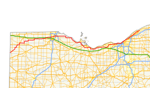 Маршрут SR 2 выделен красным | ||||
| Информация о маршруте | ||||
| Поддерживается Odot | ||||
| Длина | 227,13 миль [ 1 ] (365,53 км) | |||
| Существовал | 1912 [ 2 ] -подарок | |||
| Турист маршруты | ||||
| Основные перекрестки | ||||
| Уэст -Энд | ||||
| Ист -Энд | ||||
| Расположение | ||||
| Страна | Соединенные Штаты | |||
| Состояние | Огайо | |||
| Округа | Defiance , Williams , Fulton , Lucas , Ottawa , Erie , Lorain , Cuyahoga , Lake | |||
| Шоссе | ||||
| ||||
| ||||
| ||||
Государственный маршрут 2 ( SR 2 ), ранее известный как Inter-County Highway 2 до 1921 года. [ 3 ] и государственное шоссе 2 в 1922 году, [ 4 ] на восток - запад, это шоссе пересекающее большую часть северного Огайо . Его западный термин находится на Индиана линии штата недалеко от Хиксвилла , где маршрут становится State Road 37 штата Индиана , которая продолжает в Форт -Уэйн, штат Индиана . Восточный термин маршрута находится в поселке Пейнсвилл в округе Лейк на маршруте 20 США (20).
Описание маршрута
[ редактировать ]

Он проходит через Брайана , ваузон (где он кратко становится куплетом [ 5 ] ) и входит в Большой Толедо к западу от его обмена с магистрали штата Огайо . Он продолжается на востоке от Большого Толедо и вскоре параллелью озера Эри , став автострадой возле Порт -Клинтона . От Орегона до Сандаски SR 2 является частью 293 миль (472 км) шоссе, обозначенной «Тропа Озера Эри Огайо». [ 6 ] и 22 сентября 2005 года был обозначен национальным живописным боем . [ 7 ] От Толедо до Сандаски шоссе также является частью и обозначено тур по озеру Эри Круг , который также является частью 6500 миль (10500 км) «Тур Великих озер Круг». [ 8 ] Затем он проходит Сандаски , где он встречает нас, маршрута 250 (US 250) и США 6 , и отделяется от озера в качестве автострады и пересекает сельскую округ Эри , прежде чем въехать в округ Лорейн . Рядом с Элирией он присоединяется к Interstate 90 (I-90), чей маршрут он разделяет Рокки-Ривер , где он следует за SR 254 вдоль Детройт-роуд в Лейквуд . Здесь он снова присоединяется к нам 6, а также на нас 20 на бульваре Клифтон. Затем он становится частью Мемориального Shoreway Кливленда в Кливленде , снова присоединившись к I-90 возле аэропорта Берк-Лейкфронт . Эти две автомагистрали разделены возле Евклида , и SR 2 продолжается вдоль автострады Лейкленд до Пейнсвилла, питаясь в США 20 восток. SR 2 служит маршрутом доступа к достопримечательностям озера на озере Эри из Толедо и Кливленда и в качестве альтернативы The Ohio Turnpike.
Отрезка SR 2 от Толедо до Сандаски проходит несколько достопримечательностей. Национальный заповедник Оттавы находится к востоку от 19 SR в городке Кэрролл. Он расположен на 733 акрах (297 га) вместе с атомной электростанцией Дэвис -Бессе .
SR 2 - самый низкий пронумерованный государственный маршрут в Огайо. SR 1 был выведен из эксплуатации в 1965 году.
Нами
[ редактировать ]Секция SR 2, которая проходит через округ Эри, называется «Шоссе Джеки Майер Мисс Америка» и назван в честь Джеки Майера , бывшей мисс Америки , которая родилась и выросла в Сандаски . [ 9 ]
Раздел SR 2, который проходит через Уиллоуби, называется «Шоссе Брайана Монтгомери Мемориал» [ 10 ] в честь морского капрала Ланса , который был убит в войне в Ираке в августе 2005 года. [ 11 ]
История
[ редактировать ]- 1912: Intercounty Highway 2 runs from Cleveland to the Pennsylvania state line.[12]
- 1923: Route is extended to follow current US 6 alignment from the Indiana state line to Bryan, and current SR 51 and US 20 from Toledo to the Pennsylvania state line.[13]
- 1926–1927: Rerouted from Toledo to Cleveland along previous SR 23 alignment from Toledo to Port Clinton, previously unnumbered route from Port Clinton to 2 miles (3.2 km) west of Sandusky, and previous SR 12 from 2 miles (3.2 km) west of Sandusky to Cleveland. Cleveland-to-Pennsylvania alignment certified as US 20.[13]
- 1931: Extended east to Willoughby along previously unnumbered route (St. Clair).
- 1931–1932: Western terminus shortened to Bryan, Bryan to Indiana state line certified as US 6
- 1936: Extended to Indiana state line via the former SR 108 alignment from Hicksville to Bryan, and the former SR 18 alignment from the Indiana state line to Hicksville, with which it was dually certified along this route until 1940.[13]
- 1939: SR 18 alignment removed from SR 2 alignment west of Hicksville.[13]
- 1939: Route extended east to Lost Nation Road in Willoughby.
- 1941: SR 2 from West 6th to East 9th moved from Lakeside Avenue to the Lakefront Highway, later called the Cleveland Memorial Shoreway. Lakeside certified as SR 2 temporary.
- 1962: Extended east to SR 283 in Painesville; Euclid-to-Painesville alignment upgraded to freeway.[13]
- 1967: 9 miles (14 km) west of Sandusky to 4 miles (6.4 km) west of Sandusky upgraded to freeway, and rerouted on the bypass around Sandusky on former US 6 alignment.[13]
- 1967: Route extended to its current eastern terminus at US 20 in Painesville Township
- 1968: From SR 163 to 9 miles (14 km) west of Sandusky upgraded to freeway.[13]
- 1970: From 2 miles (3.2 km) west of Amherst to SR 83 (SR 76 at that time) upgraded to freeway; from 4 miles (6.4 km) east of Amherst to SR 83 dually certified with I-90.[13]
- 1973–1975: OH 2 Alt is deleted as discontinuous sections of Route 2 are moved from US 6 to I-90.
- 1976: From Ceylon to 2 miles (3.2 km) west of Amherst upgraded to freeway.[13]
- 1977: From SR 83 to Rocky River upgraded to freeway and dually certified with I-90.[13]
- August 30, 1990: From Huron to Ceylon upgraded to freeway.[14]
Major intersections
[edit]| County | Location | mi[1] | km | Old exit | New exit[15] | Destinations | Notes |
|---|---|---|---|---|---|---|---|
| Defiance | Hicksville Township | 0.00 | 0.00 | Continuation into Indiana | |||
| Hicksville | 2.34 | 3.77 | Southern end of SR 49 concurrency | ||||
| 2.65 | 4.26 | Southern end of SR 18 concurrency | |||||
| 3.06 | 4.92 | Northern end of SR 18 concurrency | |||||
| 3.71 | 5.97 | Northern end of SR 49 concurrency | |||||
| Farmer Township | 11.16 | 17.96 | Western end of SR 249 concurrency | ||||
| 13.17 | 21.20 | Eastern end of SR 249 concurrency | |||||
| Williams | Center Township | 16.54 | 26.62 | Southern terminus of SR 576 | |||
| 17.79 | 28.63 | Western end of US 6 concurrency | |||||
| Pulaski Township | 20.23 | 32.56 | Eastern end of US 6 concurrency; southern end of US 127/SR 15 concurrency | ||||
| Bryan | 22.50 | 36.21 | Northern end of US 127/SR 15 concurrency; western end of SR 34 concurrency | ||||
| Springfield Township | 29.78 | 47.93 | Eastern end of SR 34 concurrency; southern end of SR 191 concurrency | ||||
| Stryker | 31.66 | 50.95 | Northern end of SR 191 concurrency | ||||
| Fulton | Archbold | 38.02 | 61.19 | Southern end of SR 66 concurrency | |||
| German Township | 39.52 | 63.60 | Northern end of SR 66 concurrency | ||||
| Wauseon | 48.30 | 77.73 | SR 2D east (Fulton Street) | Western terminus of SR 2D; eastbound unsigned | |||
| 48.67 | 78.33 | Southern end of SR 108 concurrency | |||||
| 49.27 | 79.29 | Eastern terminus of SR 2D; signed as SR 2 westbound | |||||
| 50.27 | 80.90 | Northern end of SR 108 concurrency; western end of US 20A concurrency | |||||
| York Township | 55.30 | 89.00 | Western end of SR 109 concurrency | ||||
| Delta | 57.06 | 91.83 | Eastern end of SR 109 concurrency | ||||
| Swanton | 63.42 | 102.06 | Western end of SR 64 concurrency | ||||
| Lucas | Swanton Township | 63.96 | 102.93 | Eastern end of SR 64 concurrency | |||
| 65.71 | 105.75 | Eastern end of US 20A concurrency; western end of SR 295 concurrency | |||||
| 66.50 | 107.02 | Eastern end of SR 295 concurrency | |||||
| Monclova Township | 67.41 | 108.49 | Exit 52 on I-80/I-90/Ohio Tpk. | ||||
| Springfield Township | 73.60– 73.93 | 118.45– 118.98 | Exit 8 on I-475/US 23 | ||||
| Toledo | 75.37 | 121.30 | |||||
| 79.21 | 127.48 | Former US 25 | |||||
| 80.76 | 129.97 | Former US 24 | |||||
| 82.08 | 132.09 | Western end of SR 51/SR 65 concurrency | |||||
| 82.08– 82.78 | 132.09– 133.22 | Anthony Wayne Bridge over Maumee River | |||||
| 82.88 | 133.38 | Eastern end of SR 65 concurrency | |||||
| 83.33 | 134.11 | Eastern end of SR 51 concurrency | |||||
| Oregon | 84.69– 84.76 | 136.30– 136.41 | Western end of LECT concurrency; exit 7 on I-280 | ||||
| Ottawa | Benton Township | 99.12 | 159.52 | Eastern terminus of SR 579 | |||
| 100.88 | 162.35 | Northern terminus of SR 590 | |||||
| Carroll Township | 104.84 | 168.72 | Northern terminus of SR 19 | ||||
| Erie Township | 111.05 | 178.72 | Northern terminus of SR 358 | ||||
| 114.23 | 183.84 | Rest Area (at grade intersection) | |||||
| 114.82 | 184.78 | Western end of freeway section | |||||
| 115.66 | 186.14 | 115 | Eastbound entrance and westbound exit | ||||
| Bay Township | 117.07– 117.59 | 188.41– 189.24 | 117 | Western end of SR 53 concurrency | |||
| Portage Township | 120.96– 121.62 | 194.67– 195.73 | 121 | Double trumpet interchange; signed as 121A (west) and 121B (east); via unsigned SR 2C | |||
| 123.38– 123.90 | 198.56– 199.40 | 124 | Eastern end of SR 53 concurrency | ||||
| Danbury Township | 124.25– 124.88 | 199.96– 200.97 | 125A | Northern end of SR 269 concurrency | |||
| 125B | Bay Shore Road | Access to Bay Shore Road from SR 269 | |||||
| Sandusky Bay | 126.05– 126.51 | 202.86– 203.60 | Thomas A. Edison Memorial Bridge | ||||
| Erie | Margaretta Township | 127.82– 128.52 | 205.71– 206.83 | 128 | Southern end of SR 269 concurrency | ||
| Sandusky | 130.29– 130.99 | 209.68– 210.81 | 131 | Eastern terminus of LECT concurrency | |||
| Margaretta Township | 132.18– 132.91 | 212.72– 213.90 | 133 | Eastern terminus of SR 101 | |||
| Perkins Township | 134.07– 134.85 | 215.76– 217.02 | 134 | ||||
| 137.87– 138.72 | 221.88– 223.25 | 138 | |||||
| Huron | 141.41– 142.12 | 227.58– 228.72 | 142 | Western end of US 6 concurrency | |||
| 142.28– 142.34 | 228.98– 229.07 | 143 | Eastern end of US 6 concurrency; eastbound exit and westbound entrance | ||||
| Huron Township | 144.37– 144.97 | 232.34– 233.31 | 145 | ||||
| Berlin Township | 146.72– 147.53 | 236.12– 237.43 | 147 | Berlin Road | |||
| 148.16– 148.90 | 238.44– 239.63 | 148 | |||||
| Vermilion Township | 155.52– 156.21 | 250.29– 251.40 | 156 | ||||
| Lorain | Brownhelm Township | 157.17– 157.69 | 252.94– 253.78 | Lorain Service Plaza / Rest Area | |||
| Vermillion | 158.24– 158.55 | 254.66– 255.16 | 158 | Vermilion Road / Sunnyside Road | Exit numbered only on eastbound side | ||
| 160.05– 160.40 | 257.58– 258.14 | 160 | Exit numbered only on westbound side | ||||
| Amherst | 162.54– 162.93 | 261.58– 262.21 | 163 | North Lake Street / Oak Point Road | |||
| 164.11– 164.52 | 264.11– 264.77 | 164 | |||||
| Lorain | 166.37– 166.75 | 267.75– 268.36 | 166 | Middle Ridge Road / Broadway Avenue | |||
| Elyria Township | 168.02 | 270.40 | — | Western end of I-90 concurrency; westbound exit and eastbound entrance; I-90 exit 144 | |||
| Elyria | 169.03– 169.61 | 272.03– 272.96 | 145 | Exit numbers follow I-90 west of the turnpike | |||
| Sheffield | 171.49– 171.89 | 275.99– 276.63 | 148 | ||||
| Avon | 174.71– 175.10 | 281.17– 281.80 | 151 | ||||
| 176.41– 176.75 | 283.90– 284.45 | 153 | |||||
| 179.09– 179.56 | 288.22– 288.97 | 155 | Nagel Road – Avon Lake, North Ridgeville, Avon | ||||
| Cuyahoga | Westlake | 180.02– 180.64 | 289.71– 290.71 | 156 | Crocker Road / Bassett Road – Bay Village, Westlake, North Olmsted | ||
| 182.68– 183.28 | 293.99– 294.96 | 159 | |||||
| 183.92– 184.23 | 295.99– 296.49 | 160 | Clague Road | Westbound exit, eastbound entrance | |||
| Rocky River | 185.16– 185.43 | 297.99– 298.42 | Eastern end of I-90 concurrency; western end of SR 254 concurrency; no access to I-90 eastbound from SR 2 westbound; I-90 exit 161 | ||||
| Eastern end of freeway section | |||||||
| 186.50 | 300.14 | Eastern end of SR 254 concurrency; SR 254 continues along SR 2 unsigned while SR 254-D (signed as SR 254) continues along Detroit Road | |||||
| 186.82 | 300.66 | — | Interchange; western end of US 6 and LECT concurrency; westbound left exit and eastbound left entrance | ||||
| Lakewood | 187.68 | 302.04 | Western end of US 20 concurrency; eastern terminus of SR 113; northern terminus of SR 237; unsigned eastern terminus of SR 254 | ||||
| Cleveland | 191.83– 191.98 | 308.72– 308.96 | 191 | — | Lake Avenue / West Boulevard | Westbound exit and eastbound entrance; exit numbered during mid 2010s | |
| 192.36– 192.69 | 309.57– 310.10 | 192 | — | West 73rd Street | Access to West 73rd Street opened December 12, 2015;[16] exit formerly known as Edgewater Park, Whiskey Island; exit numbered during mid 2010s | ||
| 193.30– 193.38 | 311.09– 311.21 | 193A | — | West 45th Street | Eastbound exit and entrance; exit numbered during mid 2010s | ||
| 193.28– 193.40 | 311.05– 311.25 | 193 | West 49th Street | Westbound exit and entrance; exit numbered only on westbound side | |||
| 193.73 | 311.78 | Western end of freeway | |||||
| 193B | (West 25th Street) | Eastern end of US 6/US 20 concurrency; to US 6 alt & SR 3 (unsigned); eastbound exit and westbound entrance; eastbound entrance in planning stages[17] | |||||
| 194.01 | 312.23 | 194 | West 28th Street – Flats West | Westbound exit and eastbound entrance; entrance to be closed to reroute entrance traffic via 45th.[17] | |||
| 194.19– 194.65 | 312.52– 313.26 | Main Avenue Bridge over the Cuyahoga River | |||||
| 194.65 | 313.26 | 194 | Lakeside Avenue / West 6th Street | Eastbound exit and westbound entrance | |||
| 195.14– 195.18 | 314.05– 314.11 | 195B | West 3rd Street | Westbound exit and eastbound entrance | |||
| 195.17– 195.51 | 314.10– 314.64 | 195A | East 9th Street – Rock and Roll Hall of Fame | ||||
| 195.51 | 314.64 | City of Cleveland Parking | Eastbound entrance; former exit removed after 1979[18] | ||||
| 195.65– 195.79 | 314.87– 315.09 | 195B | City of Cleveland Parking | Eastbound exit and entrance, first exit | |||
| 196.05– 196.08 | 315.51– 315.56 | 195A | City of Cleveland Parking – Amtrak Station | Eastbound exit and entrance, second exit; erroneous exit number (196A) | |||
| 196.24 | 315.82 | 196B | Eastbound exit | ||||
| 196.23– 196.34 | 315.80– 315.98 | 196 | South Marginal Road | Westbound exit and entrance | |||
| 196.61– 196.86 | 316.41– 316.82 | — | Western end of I-90 westbound concurrency; westbound exit and entrance from I-90 via exit 174B; eastbound entrance via eastbound I-90 from the Innerbelt | ||||
| 196.78 | 316.69 | 196C | South Marginal Road | Eastbound exit | |||
| 196.86 | 316.82 | Western end of eastbound concurrency with I-90 | |||||
| 197.78– 198.36 | 318.30– 319.23 | 175 | East 55th Street / Marginal Roads | Exit numbers west of Dead Man's Curve follow I-90 | |||
| 198.76– 199.13 | 319.87– 320.47 | 176 | Western end of SR 283 concurrency | ||||
| 199.16– 199.51 | 320.52– 321.08 | 177 | Martin Luther King Jr. Boulevard / University Circle | ||||
| Bratenahl | 200.76– 201.20 | 323.09– 323.80 | 178 | Eddy Road – Bratenahl | |||
| 201.97 | 325.04 | 179 | Eastern end of SR 283 and LECT concurrencies; eastbound exit and westbound entrance | ||||
| Cleveland | 202.20– 202.82 | 325.41– 326.41 | 180 | East 140th Street / East 152nd Street | Signed as exits 180A (East 140th Street) and 180B (East 152nd Street) eastbound | ||
| 203.08– 203.21 | 326.83– 327.03 | 181 | East 156th Street | Westbound entrance and exit | |||
| 204.22– 204.95 | 328.66– 329.84 | 182A | East 185th Street | ||||
| 204.64– 205.75 | 329.34– 331.12 | 182B | East 200th Street | ||||
| Euclid | 205.14– 206.41 | 330.14– 332.18 | 183 | East 222nd Street | |||
| 206.80– 207.16 | 332.81– 333.39 | 184 | Signed as exits 184A (Babbitt Rd.) and 184B (E. 260th) eastbound | ||||
| 207.58– 208.16 | 334.07– 335.00 | 207 | Left exit westbound; exit numbers follow SR 2 in Lake County; eastern end of I-90 concurrency; exit 185 on I-90 westbound | ||||
| Lake | Wickliffe | 208.70– 209.01 | 335.87– 336.37 | 208 | Lloyd Road (SR 633) – Wickliffe | Access via Lakeland Boulevard | |
| Willowick–Wickliffe municipal line | 209.83– 210.38 | 337.69– 338.57 | 210 | East 305th Street – Willowick | |||
| Eastlake | 211.30– 211.64 | 340.05– 340.60 | 211 | ||||
| Willoughby | 212.35– 212.48 | 341.74– 341.95 | 212 | ||||
| 213.32– 214.02 | 343.31– 344.43 | 213 | Lost Nation Road | ||||
| Mentor | 214.94– 215.56 | 345.91– 346.91 | 215 | ||||
| 217.68– 217.96 | 350.32– 350.77 | 217 | |||||
| 220.67– 221.09 | 355.13– 355.81 | 220 | Western end of SR 44 concurrency | ||||
| Painesville Township | 221.55– 222.07 | 356.55– 357.39 | 221 | Eastern end of SR 44 concurrency | |||
| Painesville | 223.20– 223.33 | 359.21– 359.41 | 223 | ||||
| Painesville Township | 225.69– 225.78 | 363.21– 363.36 | 225 | Eastbound exit and westbound entrance | |||
| 227.13 | 365.53 | 227 | |||||
1.000 mi = 1.609 km; 1.000 km = 0.621 mi
| |||||||
Auxiliary routes
[edit]SR 2 Temporary
[edit]State Route 2 Temporary | |
|---|---|
| Location | Cleveland |
| Existed | 1941–1958 |
- State Route 2 temporary was a designation that ran from West 6th to East 9th along Lakeside Avenue in downtown Cleveland. The designation was added when the final alignments of SR 2 were moved to the then new Lakeside Highway, later referred to as the Cleveland Memorial Shoreway. The route's eastern terminus was moved to Public Square via Ontario St. in 1957.
SR 2C
[edit]State Route 2C | |
|---|---|
| Location | Port Clinton |
| Length | 0.798 mi[1] (1,284 m) |
| Existed | 1967–present |
- State Route 2C is an unsigned connecting road that runs from State Route 163 to State Route 2 and State Route 53 near Port Clinton in Ottawa County, Ohio. State Route 2C was constructed as an access road for the SR 2–SR 163 interchange.[19]
SR 2D
[edit]State Route 2D | |
|---|---|
| Location | Wauseon |
| Length | 1.184 mi[1] (1.905 km) |
| Existed | 1972–present |
- State Route 2D is part of a couplet in Wauseon, Ohio that is signed as State Route 2.[5][20] SR 2D is signed as SR 2 westbound,[20][21] while SR 2D is signed as SR 2 eastbound,[22] (except west of East Elm Street, where SR 2D meets SR 2 at its western terminus[23]). The route ends at the corner of East Linfoot Street and North Shoop Avenue.[20]
Cultural references
[edit]In the 2014 film Captain America: The Winter Soldier, the Cleveland Memorial Shoreway is used to depict a freeway in Washington, D.C.[24]
Gallery
[edit]-

-
 Wide variant of State Route 2 signage at US 6 in Bryan
 -
 SR 2 in Bryan
 -
 SR 2 in Farmer
 -
 US 20A / SR 2 in Delta
 -
 US 20A / SR 2 along the North Star BlueScope Steel mill located southwest of Delta
 -
 US 127 / SR 2 / SR 15 in Bryan
 -
 Davis–Besse Nuclear Power Station viewed from Ohio State Route 2
 -
 Cleveland Memorial Shoreway in 2013
 -
 Cleveland Memorial Shoreway in 1973 (Former parking lot exit pictured)
 -
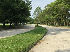 Abandoned stretch of SR 2 in Gordon Park
 -
 Edgewater Park overpass in Cleveland


References
[edit]- ^ Jump up to: a b c d "Data Download - ODOT TIMS (Road Inventory shapefile)". Ohio Department of Transportation. Retrieved April 14, 2019.
- ^ Ohio State Highway Department (1912). Map of Ohio Showing Inter-County Highways (PDF) (Map). c. 1:563,200. Columbus: Ohio State Highway Department. OCLC 13716556.
- ^ Ohio Department of Highways and Public Works (September 1921). Highway Map of Ohio Showing Conditions for Travel (PDF) (Map). c. 1:563,200. Columbus: Ohio Department of Highways and Public Works.
- ^ Ohio Department of Highways and Public Works (April 1922). Map of Ohio State Highways Showing All Improved Roadways and Indicating System Constructed Under Administration of Gov. Harry L. Davis (PDF) (Map). c. 1:563,200. Columbus: Ohio Department of Highways and Public Works.
- ^ Jump up to: a b Ohio Department of Transportation. "Technical Services Straight Line Diagrams: SR 2D, Fulton County" (PDF). Retrieved October 12, 2013.
- ^ "Lake Erie Ohio Coastal Trail".[full citation needed]
- ^ "National Scenic Byway". Archived from the original on June 21, 2010. Retrieved March 16, 2010.[full citation needed]
- ^ "Great Lakes Circle". Archived from the original on July 25, 2010.[full citation needed]
- ^ Ohio Revised Code 5533.66[full citation needed]
- ^ Ohio Revised Code 5533.63.2[full citation needed]
- ^ "Willoughby Family Mourns Loss of Marine Son". Cleveland: WEWS-TV. August 3, 2005. Archived from the original on November 5, 2005. Retrieved November 11, 2015.
- ^ "Pages: Official Transportation Maps". Ohio Department of Transportation.
- ^ Jump up to: а беременный в дюймовый и фон глин час я Дж Симпсон, Джон. «Маршрут 2» . Неофициальный веб -сайт штата Огайо . Архивировано из оригинала 5 февраля 2005 года. [ Самостоятельно опубликованный источник ]
- ^ Тома, Полин (31 августа 1990 г.). «Селеста открывает обход Гурона» . Простой дилер . Кливленд . Получено 7 октября 2012 года .
- ^
- Китско, Джеффри Дж. (18 июня 2004 г.). "OH 2 Exit Guide" . Шоссе Огайо . Архивировано из оригинала 18 июня 2004 года . Получено 8 января 2016 года . [ Самостоятельно опубликованный источник ]
- Кицко, Джеффри Дж. (17 июня 2004 г.). «Межгосударственный путеводитель по выходу 90» . Шоссе Огайо . Архивировано из оригинала 17 июня 2004 года . Получено 8 января 2016 года . [ Самостоятельно опубликованный источник ]
- Фаннин, Марк; Горте, Брэндон М.; Слейтер, CC "Ohio 2 East" . Страница Western Reserve Exit Guide . Архивировано с оригинала 4 марта 2016 года . Получено 20 мая 2016 года . [ Самостоятельно опубликованный источник ]
- Фаннин, Марк; Горте, Брэндон М.; Слэйтер, CC "Огайо 2/Мемориальное Мемориальное Уэст -Уэст" . Страница Western Reserve Exit Guide . Архивировано с оригинала 4 марта 2016 года . Получено 20 мая 2016 года . [ Самостоятельно опубликованный источник ]
- ^ Огайо Департамент транспортных средств 12 (12 декабря 2015 г.). «Западный 73 -й разгибание открывает ссылку на озеро Эри на западной стороне Кливленда» (пресс -релиз). Огайо Департамент транспорта . Получено 16 декабря 2015 года .
{{cite press release}}: CS1 Maint: числовые имена: список авторов ( ссылка ) - ^ Jump up to: а беременный «Страницы - Уэст -Шорей и W 28th/W 45th Streets» . Архивировано с оригинала 15 января 2015 года.
- ^ «Исторические карты Кливленда (1979)» . Peoplemaps.esri . Архивировано с оригинала 16 марта 2016 года . Получено 18 марта 2016 года .
- ^ Огайо Департамент транспортных услуг Технические услуги по прямой линии для SR 2C Archied 14 октября 2013 г. на The Wayback Machine
- ^ Jump up to: а беременный в «Восточный термин Sr 2d» (Map). Карты Google . Получено 28 октября 2015 года .
- ^
- «Восточный термин SR 2d, лицом к югу» (карта). Карты Google . Получено 28 октября 2015 года .
- «Первый знак на запад» (карта). Карты Google . Получено 28 октября 2015 года .
- «Второй знак на запад» (карта). Карты Google . Получено 28 октября 2015 года .
- «Третий знак на запад» (карта). Карты Google . Получено 28 октября 2015 года .
- «Четвертый знак на запад» (карта). Карты Google . Получено 28 октября 2015 года .
- «Пятый Знак на запад» (карта). Карты Google . Получено 28 октября 2015 года .
- «Восточный JCT с западным SR 2» (MAP). Карты Google . Получено 28 октября 2015 года .
- ^
- «Первый знак на восток» (карта). Карты Google . Получено 28 октября 2015 года .
- «Второй знак на восток» (карта). Карты Google . Получено 28 октября 2015 года .
- «Третий знак на восток» (карта). Карты Google . Получено 28 октября 2015 года .
- «Четвертый восточный знак» (карта). Карты Google . Получено 28 октября 2015 года .
- «Пятый знак в восточном направлении» (карта). Карты Google . Получено 28 октября 2015 года .
- «Шестой знак восточного направления» (карта). Карты Google . Получено 28 октября 2015 года .
- «Седьмой знак на восток» (карта). Карты Google . Получено 28 октября 2015 года .
- «Западный JCT с западным SR 2» (MAP). Карты Google . Получено 28 октября 2015 года .
- ^ «Западный термин Sr 2d» (Map). Карты Google . Получено 28 октября 2015 года .
- ^ О'Коннор, Клинт (28 марта 2014 г.). «Кливленд повсюду" Капитан Америка: Зимний солдат " . Простой дилер . Кливленд . Получено 28 августа 2016 года .
Внешние ссылки
[ редактировать ] СМИ, связанные с штатом Огайо, маршрут 2 в Wikimedia Commons
- Государственные автомагистрали в Огайо
- Транспорт в округе Defiance, штат Огайо
- Транспорт в округе Уильямс, штат Огайо
- Транспорт в округе Фултон, штат Огайо
- Транспорт в округе Лукас, штат Огайо
- Транспорт в округе Оттава, штат Огайо
- Транспорт в округе Эри, штат Огайо
- Транспорт в округе Лорейн, штат Огайо
- Транспорт в округе Кайахога, штат Огайо
- Транспорт в округе Лейк, штат Огайо
- Транспорт в Толедо, штат Огайо
- Транспорт в Кливленде
- США. Маршрут 6
- США. Маршрут 20