Старый макинак точечный свет

 Старый Mackinac Point Light в ноябре 2022 года | |
 | |
| Расположение | Макино -Сити , Мичиган |
|---|---|
| Координаты | 45 ° 47′15 ″ N 84 ° 43′46 ″ W / 45,78750 ° N 84,72944 ° W |
| Башня | |
| Сконструировано | 1892 |
| Фундамент | Айльно -известняк [ 5 ] |
| Строительство | Кремовый город Кирпич |
| Высота | 50 футов (15 м) [ 1 ] [ 2 ] |
| Форма | Цилиндрический " замок " с прикрепленным жилищем [ 1 ] |
| Маркировка | Естественный с черным фонарем |
| Наследство | National Register of Historic Places listed place |
| Light | |
| First lit | 1892 |
| Deactivated | 1957 |
| Focal height | 62 feet (19 m)[3] |
| Lens | Fourth order Fresnel lens |
| Range | 14 nautical miles; 26 kilometres (16 mi)[4] |
Mackinac Point Lighthouse | |
 U.S. Coast Guard vintage photo | |
| Location | Michilimackinac State Park, Mackinaw City, Michigan |
| Area | 0.9 acres (0.36 ha) |
| NRHP reference No. | 69000068[6] |
| Significant dates | |
| Added to NRHP | October 1, 1969 |
| Designated MSHS | April 14, 1972 |
Old Mackinac Point Light - это деактивированный маяк , расположенный на северной части нижнего полуострова в штате Мичиган США . Маяк является частью государственного парка форта Мичилимакинак в деревне Макино -Сити к востоку от моста Макинак .
Маяк был построен в 1892 году вдоль Макинового пролива на стыке озера Мичиган и озера Гурон . Он был деактивирован в 1957 году и в настоящее время служит музеем. [ 7 ] [ 8 ] [ 9 ]
История
[ редактировать ]Подготовка
[ редактировать ]Еще до появления европейских исследователей проливы Макинак были значительной опасностью для путешественников с водой. Следовательно, перед маяками Оджибва зажег на берег огнем. [ 10 ]
В начале 19 -го века, когда большое движение судов, увеличиваемое из озера Гурона в пролив, в 1829 году был сделан первый шаг в охране пролива в 1829 году, посредством строительства маяка Буа -Бланка , чтобы обоих направляющих моряков в том, чтобы сделать западные повороты в проливы, и предупредить их о косяках и пятнах, окружающих остров.
Три года спустя, в 1832 году, Конгресс выступил по рекомендации Стивена Плезантона о том, чтобы световой корабль был поставлен на Shoal Waugoshance в качестве первой попытки отметить западный вход в пролив. В 1838 году лейтенант Джеймс Т. Хоманс сообщил, что свет был совершенно неадекватным. Он рекомендовал лучшее решение для WaugoShance, а также чтобы свет был построен на точке к западу от гавани Макино. Ничего не пришло из рекомендаций Хомана. В 1854 году новая администрация маяка решила (против рекомендации местных жителей) пролить свет на точку МакГулпина , примерно в 3 милях (4,8 км) к западу от Олд -Пойнт Макино.
Construction
[edit]In 1889, the United States Lighthouse Board realized that Mackinaw Point was a better location. Their first inclination was to put a fog signal there, but when asking Congress for funding, they requested funding for both a fog signal and a first class lighthouse. Congress chose to accept their recommendation, but only voted the funding for a steam-powered fog-signal. The fog signal was built in 1890.[11] The signal proved to be exceptionally necessary for navigation in the often fog-choked Straits of Mackinac; during one exceptionally humid fortnight, the Old Mackinac Point signal personnel reported burning 52 cords of stove wood in order to keep steam up for the foghorn.[12]
The lighthouse "grew out of the fog station."[1][13] In March 1891, Congress finally authorized the funding for a light station and the board acted quickly. Bidding was difficult, but in 1892, "on a foundation of ashlar limestone, the tower and attached keeper’s dwelling were both constructed of Cream City brick, trimmed with Indiana Limestone. The double-walled cylindrical tower was laid with an outside diameter of 13 feet 4 inches (4.06 m), and as each course was added, rose to a height of 45 feet (14 m), surmounted by a circular iron gallery and an 8-foot-8-inch (2.64 m) diameter watch room, which was in turn capped by a prefabricated octagonal iron lantern."[14] The lens is a fourth order Fresnel Lens.
Its light was visible for 14 nautical miles; 26 kilometres (16 mi), which made it "particularly valuable" to the railroad car ferries SS Chief Wawatam and SS Sainte Marie operated between Mackinaw City and St. Ignace.[4]
Deactivation and preservation
[edit]The completion of the Mackinac Bridge in 1957 eliminated the need for the light. Since the Mackinac Bridge has lights on it at night, the bridge became a much better aid to navigation than the light.

In 1960, the lighthouse property was purchased by the Mackinac Island State Park Commission, incorporating it into surrounding Fort Michilimackinac State Park. The Old Mackinac Point Lighthouse was added to the National Register of Historic Places in November 1969, as Reference #69000068 (listed as: Mackinac Point Lighthouse).[13]
It is also a registered Michigan Historic Landmark. The Michigan Historical Marker on site states:
- Mackinac Point Lighthouse.[13] The lighthouse complex, including the lightkeeper's quarters and tower, was reopened to the public in 2004 by Mackinac State Historic Parks as part of the Fort Michilimackinac complex. The light's original Fresnel lens is on display. An admission fee is charged.
A state historical marker was erected in 1972. It is Registered Site S0377. The marker states:
- "This lighthouse is opposite the turning point for ships making the difficult passage through the Straits of Mackinac, one of the busiest crossroads of the Great Lakes. McGulpin Point Light, two miles to the west, had been established in 1856, but it was not visible from all directions. In 1889 Congress appropriated funds for the construction of a steam-powered fog signal here, which went into operation on November 5, 1890. Construction of the light tower and attached lightkeepers' dwelling began, and the light was first displayed on October 25, 1892. Heavy iron and brass castings were used throughout the structure, and the light was visible to ships sixteen miles away. In operation until 1958, the lighthouse is now a maritime museum."[15]
In 2000, serious restoration was undertaken, with the intent of restoring it to its appearance around 1910. The lighthouse is reopened to the public, and the castle-style structure, which design is unique in the Great Lakes was restored.[16] the first floor is fully accessible, and includes period furnishings and accoutrement, plus hands-on exhibits that test one's nighttime navigation skills, light a miniature Fresnel lens, and put on Lighthouse keeper clothing. Historic interpreters lead tours up the tower and into the lantern room.[4]
Starting in 2018, major exterior and interior masonry restoration was undertaken by National Restoration Inc.
Current status and getting there
[edit]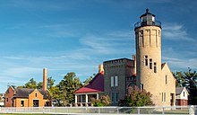

Adjacent to the Mackinac Bridge, the park offers a good view of the bridge and boat traffic.[4]
Admission is through the 1907 Fog Signal Building, which houses the museum store. An admission fee is charged. Pets are welcome.
The tower is open to the public.[17]
The lighthouse is located within Michilimackinac State Park, just a few hundred feet east of the Mackinac Bridge and the Colonial Michilimackinac Visitors Center. At this time the light is a museum run by Mackinac Parks Commission Archived 2006-08-13 at the Wayback Machine.
Because of its prime location and exposure to tourists, plus its unique picturesque form and color, it is the subject of photographs,[18] drawings, and needlepoint illustrations. Historical photographs are a prominent feature of the Mackinac Island State Park Commission website.[19]
An exciting and expensive alternative is to charter a seaplane to make a tour of the Mackinac Straits and environs.[20]
See also
[edit]- Great Lakes Storm of 1913
- Shipwrecks of the 1913 Great Lakes storm
- List of victims of the 1913 Great Lakes storm
- Lighthouses in the United States
Further reading
[edit]- "A Tour of the Lights of the Straits." Michigan History 70 (Sep/Oct 1986), pp. 17–29.
- Brisson, Steven (2001) Brief history, Old Mackinac Point Lighthouse, Mackinac Parks Archived 2009-12-22 at the Wayback Machine, Mackinac Island State Park Commission. Adapted from: Old Mackinac Point Light Station. Mackinac History: A Continuing Series of Illustrated Vignettes. Vol. III, no. 5. Mackinac Island: Mackinac Island State Park Commission.
- Brisson, Steven C. (Mackinac State Historic Parks chief curator). Old Mackinac Point Lighthouse: A History & Pictorial Souvenir (1/29/2008).[21]
- Hyde, Charles K., and Ann and John Mahan. The Northern Lights: Lighthouses of the Upper Great Lakes. Detroit: Wayne State University Press, 1995. pp. 36–46. ISBN 0-8143-2554-8 ISBN 9780814325544.
- Pepper, Terry. "Old Mackinac Point Light". Seeing The Light. terrypepper.com.
References
[edit]- ^ Jump up to: a b c Michigan Lighthouse Conservancy, Old Mackinac Point Light.
- ^ Pepper, Terry. "Database of Tower Heights". Seeing the Light. terrypepper.com. Archived from the original on 2000-09-18. Retrieved 2009-09-12.
- ^ Pepper, Terry. "Database of Focal Heights". Seeing the Light. terrypepper.com. Archived from the original on 2008-08-30. Retrieved 2009-09-12.
- ^ Jump up to: a b c d Wobser, David. "Old Mackinac Point". Boatnerd.com. Archived from the original on 2013-01-28. Retrieved 2009-05-02.
- ^ Brisson, Steven (2001) Brief history, Old Mackinac Point Lighthouse, Mackinac Parks Archived 2009-12-22 at the Wayback Machine, Mackinac Island State Park Commission.
- ^ "National Register Information System". National Register of Historic Places. National Park Service. March 13, 2009.
- ^ Old Mackinac Point Lighthouse, official website.
- ^ Amateur Radio Lighthouse Society Old Mackinac Point (Straits of Mackinac) Light, ARLHS USA-463.
- ^ Amateur Radio Lighthouse Society, World List of Lights (WLOL).
- ^ Old Mackinac Point Lighthouse. How Stuff Works.
- ^ Lighthouse Central, Old Mackinac Point light The Ultimate Guide to East Michigan Lighthouses by Jerry Roach (Publisher: Bugs Publishing LLC - July 2006). ISBN 0-9747977-1-5; ISBN 978-0-9747977-1-7.
- ^ Roberts, Bruce; Jones, Ray. (September 2002) American Lighthouses, 2nd: A Definitive Guide p. 250 Publisher: Globe Pequot Press 304 pp[permanent dead link] ISBN 1-59223-102-0; ISBN 978-1-59223-102-7; ISBN 978-0-7627-2269-3.
- ^ Jump up to: a b c National Park Service Maritime History Project, Inventory of Historic Lights, Old Mackinac Point Lighthouse. Archived 2006-10-06 at the Wayback Machine
- ^ Pepper, Terry. "Old Mackinac Point Light". Seeing The Light. terrypepper.com.
- ^ "Michigan Historical Markers, Old Mackinac Point Light". Archived from the original on 2014-07-17. Retrieved 2008-04-06.
- ^ Rowlett, Russ. "Lighthouses of the United States: Michigan's Eastern Lower Peninsula". The Lighthouse Directory. University of North Carolina at Chapel Hill.
- ^ Old Mackinac Point Light, Detroit News.
- ^ Light house friends, Old Mackinac Point Lighthouse.
- ^ «Исторические фотографии старого Mackinac Point Light» . Архивировано из оригинала на 2009-05-24 . Получено 2009-07-11 .
- ^ Сток, Кейт, гидросамолетный тур по проливам .
- ^ Старый Mackinac Point Light Press Release. Архивированный 2008-03-04 на The Wayback Machine
Внешние ссылки
[ редактировать ]- История и текущая информация о старом маяке Mackinac Point.
- Аэрофотоснимки, старый Mackinac Point Light, Marinas.com.
- Huelse, Клаус- моя страница маяка: маяки США по историческим открыткам- исторические изображения открыток США, маяки , исторический просмотр карты старой макияр Mackinac Point.
- Интерактивная карта маяков в Северном озере Мичиган.
- Озеро Гурон Северные маяки, нанесенные на карту Google
- Маяки в проливах Макинак, друзья -маяки.
- Список и информация для маяков в Северном озере Мичиган.
- Mackinac Parks, Old Mackinac Point Lighthouse, официальный сайт.
- Спутниковое представление , Google Maps .
- Old Mackinac Point Lighthouse - Маяки США


| Базы данных управления авторитетом : географический |
|---|