Музаффаргархский район

Музаффаргархский район
Район | |
|---|---|
 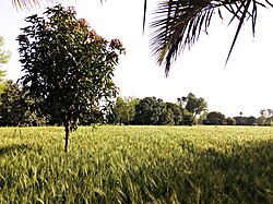 Top: Tomb of Sheikh Sadan Bottom: Fields in Muzaffargarh district | |
 District Government logo | |
 Map of Muzaffargarh District highlighted in red | |
| Coordinates: 30°4′10″N 71°11′39″E / 30.06944°N 71.19417°E | |
| Country | |
| Province | |
| Division | Dera Ghazi Khan |
| Headquarters | Muzaffargarh |
| Government | |
| • Type | District Government |
| • Deputy Commissioner | Mian Usman Ali [1] |
| • District Police Officer | Syed Hasnain Haider[2] |
| • District Health Officer | Allah Bux Khan |
| Area | |
| • Total | 4,778 km2 (1,845 sq mi) |
| Population | |
| • Total | 5,015,325 |
| • Density | 1,000/km2 (2,700/sq mi) |
| Time zone | UTC+5 (PST) |
| Number of Tehsils | 3 |
| Website | muzaffargarh |
район ( урду : ضِلع مُظفّرگڑھ ) является районом Пенджабской Музаффаргархский провинции Пакистана. Его столица - город Музаффаргарх . Он лежит на берегу реки Ченаб .
Администрация
[ редактировать ]Район административно разделен на следующие три техсила (подразделения), которые содержат в общей сложности 93 совета профсоюзов : [ 4 ]
| Техсил | Количество профсоюзов |
|---|---|
| Алипур | 14 |
| Джатои | 16 |
| Музаффаргарх | 35 |
| Общий | 65 |
Демография
[ редактировать ]Население
[ редактировать ]| Year | Pop. | ±% p.a. |
|---|---|---|
| 1951 | 446,038 | — |
| 1961 | 532,015 | +1.78% |
| 1972 | 756,221 | +3.25% |
| 1981 | 1,048,243 | +3.69% |
| 1998 | 1,827,465 | +3.32% |
| 2017 | 4,328,549 | +4.64% |
| 2023 | 5,015,325 | +2.48% |
| Sources:[5] | ||
At the time of the 2017 census, Muzaffargarh had a sex ratio of 944 females per 1000 males and a literacy rate of 43.41% for males and 32.31% for females. 444,264 (14.90%) lived in urban areas. 967,074 (32.44%) were under 10 years of age.[6] In the 2023 census, Muzaffargarh had a population of 5,015,325[7]
Religion
[edit]| Religious group |
1941[8]: 62–63 | 2017 | 2023[9] | |||||||||
|---|---|---|---|---|---|---|---|---|---|---|---|---|
| Pop. | % | Pop. | % | Pop. | % | |||||||
| Islam |
360,868 | 86.29% | 2,977,231 | 99.87% | 4,992,312 | 99.6% | ||||||
| Hinduism |
53,458 | 12.78% | 332 | 0.01% | 706 | 0.01% | ||||||
| Sikhism |
3,280 | 0.78% | — | — | 100 | 0% | ||||||
| Christianity |
162 | 0.04% | 2,565 | 0.09% | 17,620 | 0.32% | ||||||
| Ahmadi | — | — | 845 | 0.03% | 1,197 | 0.02% | ||||||
| Others | 426 | 0.1% | 75 | 0% | 189 | 0% | ||||||
| Total Population | 418,194 | 100% | 2,981,048 | 100% | 5,012,124 | 100% | ||||||
| Note: 1941 figures are for Muzaffargarh and Alipur tehsils of Muzaffargarh District, which roughly corresponds to present-day Muzaffargarh district. | ||||||||||||
| Religious group |
1901[10] | 1911[11][12] | 1921[13] | 1931[14] | 1941[15] | |||||
|---|---|---|---|---|---|---|---|---|---|---|
| Pop. | % | Pop. | % | Pop. | % | Pop. | % | Pop. | % | |
| Islam |
350,177 | 86.32% | 494,915 | 86.91% | 493,369 | 86.79% | 513,265 | 86.79% | 616,074 | 86.42% |
| Hinduism |
52,221 | 12.87% | 68,158 | 11.97% | 69,878 | 12.29% | 72,577 | 12.27% | 90,643 | 12.72% |
| Sikhism |
3,225 | 0.8% | 6,322 | 1.11% | 4,869 | 0.86% | 5,287 | 0.89% | 5,882 | 0.83% |
| Christianity |
33 | 0.01% | 60 | 0.01% | 356 | 0.06% | 246 | 0.04% | 227 | 0.03% |
| Zoroastrianism |
0 | 0% | 4 | 0% | 0 | 0% | 0 | 0% | 0 | 0% |
| Jainism |
0 | 0% | 1 | 0% | 6 | 0% | 0 | 0% | 0 | 0% |
| Buddhism |
0 | 0% | 1 | 0% | 0 | 0% | 0 | 0% | 23 | 0% |
| Judaism |
0 | 0% | 0 | 0% | 0 | 0% | 0 | 0% | 0 | 0% |
| Others | 0 | 0% | 0 | 0% | 0 | 0% | 0 | 0% | 0 | 0% |
| Total population | 405,656 | 100% | 569,461 | 100% | 568,478 | 100% | 591,375 | 100% | 712,849 | 100% |
| Note: British Punjab province era district borders are not an exact match in the present-day due to various bifurcations to district borders — which since created new districts — throughout the historic Punjab Province region during the post-independence era that have taken into account population increases. | ||||||||||
| Tehsil | Islam |
Hinduism |
Sikhism |
Christianity |
Jainism |
Others[b] | Total | |||||||
|---|---|---|---|---|---|---|---|---|---|---|---|---|---|---|
| Pop. | % | Pop. | % | Pop. | % | Pop. | % | Pop. | % | Pop. | % | Pop. | % | |
| Muzaffargargh Tehsil | 192,516 | 86.96% | 27,714 | 12.52% | 962 | 0.43% | 161 | 0.07% | 0 | 0% | 23 | 0.01% | 221,376 | 100% |
| Alipur Tehsil | 168,352 | 85.54% | 26,144 | 13.28% | 2,318 | 1.18% | 1 | 0% | 0 | 0% | 3 | 0% | 196,818 | 100% |
| Kot Adu Tehsil | 117,005 | 87.59% | 14,803 | 11.08% | 1,720 | 1.29% | 52 | 0.04% | 0 | 0% | 5 | 0% | 133,585 | 100% |
| Leiah Tehsil | 138,201 | 85.8% | 21,982 | 13.65% | 882 | 0.55% | 4 | 0% | 0 | 0% | 1 | 0% | 161,070 | 100% |
| Note1: British Punjab province era tehsil borders are not an exact match in the present-day due to various bifurcations to tehsil borders — which since created new tehsils — throughout the historic Punjab Province region during the post-independence era that have taken into account population increases. Note2: Tehsil religious breakdown figures for Christianity only includes local Christians, labeled as "Indian Christians" on census. Does not include Anglo-Indian Christians or British Christians, who were classified under "Other" category. | ||||||||||||||
Language
[edit]At the time of the 2023 census, 89.37% of the population spoke Saraiki, 3.99% Urdu and 5.19% Punjabi as their first language.[16]
Ethnicity
[edit]The most famous tribes and races are as under; Khar (offshoot of Kharal tribe), Khokhar, Dasti, Qureshi, Jatoi, Hinjra, Langrial, Thahim, Gopang, Bukhari, Gilani, Rajput, Jat and Arian.[17] The major ethnic group are the Saraiki-speaking Jat forming the majority, with Saraiki-speaking Gujjar, Baloch, Rajputs and Pathan groups in minority.[18][19]
History
[edit]Muzzaffargarh was an ancient settlement, inhabited by Mallian people of Multan region. Umayyad Arabs led by Muhammad ibn e Qasim conquered the area in early 8th century spreading Islam in the region.
In 997 CE, Sultan Mahmud Ghaznavi, took over the Ghaznavid dynasty empire established by his father, Sultan Sebuktegin, In 1005 he conquered the Shahis in Kabul in 1005, and followed it by the conquests of Punjab region. The Delhi Sultanate and later Mughal Empire ruled the region. The Punjab region became predominantly Muslim due to missionary Sufi saints whose dargahs dot the landscape of Punjab region.
Muzaffargarh region became a part of the Muslim Ghaurid Sultanate when the Persian noble Sultan Shahab-ud-Din Muhammad Ghauri conquered Punjab in 1185 CE. The area slowly developed as medieval town and many Muslim Sufi missionaries converted the local population to Islam.
During the Mughal period population increased and land under cultivation was increased. After the decline of the Mughal Empire, the Sikh Empire invaded and occupied Muzaffargarh region. The Muslims faced restrictions during the Sikh rule. Between 1765 and 1846 Muzaffargarh was occupied by the Sikhs. Two main battles between British and Sikh armies were fought in this district on 22 February 1849 the British declare victory in Punjab.
Foundation as a town
Muzaffargarh was founded in 1794 by the Governor of Multan Nawab Muzaffar Khan. The Meaning of Muzaffargarh is "Fort of Muzaffar" because the old town lies inside the walls of a fort built by Nawab Muzaffar Khan of Multan. Prior to that the place was known by a shop called "Musan Hatti", on the road leading from Multan to Dera Ghazi Khan. In 1861 it became the separate Muzaffargarh District.
After Independence 1947
After the independence of Pakistan in 1947, the minority Hindus and Sikhs migrated to India while the Muslim refugees from India settled in the Muzaffargarh District. Muslim refugees from East Punjab, Haryana, Jammu started arriving and crossed the border into Pakistan; many were given land in Muzaffargarh District to settle.
Geography and neighborhood
Muzaffargarh spreads over an area of 8,249 km2 and forms a strip between the Chenab River on its east and Indus River on its west, which pass along the Eastern and Western boundaries respectively of the district and a triangle at Alipur tehsil of the district. The district is bounded on the north by district Layyah, on the south by Bahawalpur and Rahimyar Khan districts across the river Chenab.
Districts Multan and Khanewal are on the eastern side of district Muzaffargarh, across the river Chenab. District Jhang touches it on the northeast. Dera Gahzi Khan and Rajanpur districts lie on the western side across the river Indus. It is one of oldest districts of Punjab. According to the 1998 census of Pakistan, the population of the district was 2,635,903, of which 12.75% were urban.[20] Muzaffargarh is one of oldest districts of Punjab.
2010 floods
Muzaffargarh was especially hard hit by the 2010 Pakistan floods, given its position between the Chenab and Indus rivers It is spread over an area of 8,249 km2. Muzaffargarh District lies in the strip between the rivers Chenab and Indus.
Geography and climate
[edit]| Muzaffargarh | ||||||||||||||||||||||||||||||||||||||||||||||||||||||||||||
|---|---|---|---|---|---|---|---|---|---|---|---|---|---|---|---|---|---|---|---|---|---|---|---|---|---|---|---|---|---|---|---|---|---|---|---|---|---|---|---|---|---|---|---|---|---|---|---|---|---|---|---|---|---|---|---|---|---|---|---|---|
| Climate chart (explanation) | ||||||||||||||||||||||||||||||||||||||||||||||||||||||||||||
| ||||||||||||||||||||||||||||||||||||||||||||||||||||||||||||
| ||||||||||||||||||||||||||||||||||||||||||||||||||||||||||||
The city of Muzaffargarh is located in southern Punjab province at almost the exact centre of Pakistan. The closest major city is Multan. The area around the city is a flat, alluvial plain and is ideal for agriculture, with many citrus and mango farms. There are many canals that cut across the Muzaffargarh District providing water from nearby farms. This makes the land very fertile. However usually land close to the Chenab are usually flooded in the monsoon season.
Climate
Muzaffargarh features an arid climate with very hot summers and mild winters. The city witnesses some of the most extreme weather in the country. The highest recorded temperature is approximately 54 °C (129 °F), and the lowest recorded temperature is approximately −1 °C (30 °F). The average rainfall is roughly 127 millimetres (5.0 in). Dust storms are a common occurrence within the city.
The district's towns include Basti Malik Wala, Taliri, Mauza Bahadur Dawana, Dawana Bahadur Peer Rajan Bukhsh, Kot Addu, Khangarh and Hayat Nagar.
Образование
[ редактировать ]Хотя Музаффаргарх является одним из старейших и крупнейших районов Пакистана по районам и населению, у него все еще есть только один кампус виртуального университета Пакистана . Уровень грамотности является одним из самых низких в стране. [ 21 ] В округе Музаффаргарх в общей сложности 1072 мужчин и 1 009 женщин в государственном секторе. [ 22 ] Согласно данным Департамента школьного образования, в общей сложности 5 023 мужчин и 4130 женщин -преподавателей работают в секторе образования в государственных школах округа. [ Цитация необходима ]
Леса
[ редактировать ]Площадь 100 864 акра находится в крупнейшем округе леса Лашари Вала . Существует также линейная плантация в 1250 -й миле дороги/рельсы/каналы в районе. Деревья, выращиваемые в этом районе, - это Кикар, Шишам, Миллбери, Эвкалипт, Бамбук и Кокосовой.
Примечательные люди
[ редактировать ]- Милха Сингх , знаменитый спортсмен по легкой атлетике
Примечания
[ редактировать ]- ^ Jump up to: а беременный в 1931-1941: в том числе ad-dharmis
- ^ Включая англо-индийских христиан , британских христиан , буддизм , зороастризм , иудаизм , племени , другие или не заявленные
Ссылки
[ редактировать ]- ^ «Администрация района Музаффаргарх» . mgarh.com . Архивировано с оригинала 24 декабря 2017 года . Получено 28 декабря 2017 года .
- ^ «DPO Muzaffargargh District Police» . www.mgarh.com . Архивировано с оригинала 9 января 2018 года . Получено 28 декабря 2017 года .
- ^ Jump up to: а беременный «Районные результаты / таблицы (перепись - 2023)» (PDF) . www.pbscensus.gov.pk . Пакистанское бюро статистики .
- ^ Техсилы и профсоюзы в районе Музаффаргарх-правительство Пакистанского архивирования 2012-02-09 на машине Wayback
- ^ «Население административных подразделений 1951-1998» (PDF) . Пакистанское бюро статистики .
- ^ «Окружные результаты / таблицы (перепись - 2017)» . www.pbscensus.gov.pk . Пакистанское бюро статистики .
- ^ «Перепись Пакистана 2023» (PDF) .
- ^ «Перепись Индии, 1941 Том VI Панджабская провинция» . Получено 21 июля 2022 года .
- ^ «Перепись Пакистана 2023» (PDF) .
- ^ «Перепись Индии 1901 года. Провинция " . 1901. с. 34. JStor Saoa.crl.25363739 . Получено 29 марта 2024 года .
- ^ «Перепись Индии, 1911. Том 14, Пенджаб. Пт. 2, таблицы» . 1911. с. 27. JStor Saoa.crl.25393788 . Получено 29 марта 2024 года .
- ^ Kaul, Harics (1911). "Пенджаб, том XIV, часть II " п. 27 2024Марш
- ^ «Перепись Индии, 1921. Том 15, Пенджаб и Дели. Стр. 2, таблицы» . 1921. с. 29. Jstor Saoa.crl.25430165 . Получено 29 марта 2024 года .
- ^ «Перепись Индии, 1931. Том 17, Пенджаб. Pt. 2, таблицы» . 1931. с. 277. JStor Saoa.crl.25793242 . Получено 29 марта 2024 года .
- ^ Jump up to: а беременный Комиссар по переписи Индии (1941). «Перепись Индии, 1941. Том 6, Пенджаб» . п. 42. JStor Saoa.crl.282155541 . Получено 29 марта 2024 года .
- ^ «Перепись Пакистана 2023» (PDF) .
- ^ Фиаз, Хафиз Мухаммед; Ахтар, доктор Сохаил; Ринд, Аяз Ахмад (31 декабря 2021 года). «Социокультурное состояние Южного Пенджаба: случай округа Музаффаргарх» . Международный исследовательский журнал образования и инноваций . 2 (3): 15–34. doi : 10.53575/irjei.v2.03 (21) 2,15-34 (неактивный 24 августа 2024 г.). ISSN 2710-0448 .
{{cite journal}}: CS1 Maint: doi неактивен с августа 2024 года ( ссылка ) - ^ «Газета из района Музаффаргарх» . Правительственная пресса Пенджаба. 19 июня 1884 года - через Google Books.
- ^ Отчет о переписи округа 1998 года Музаффаргарха . ПУБЛИКАЦИЯ ПЕРЕПИСЬ. Тол. 120. Исламабад: организация переписей населения, Отдел статистики, правительство Пакистана. 2000. С. 21–22.
- ^ «Центр городских ресурсов» . urckarachi.org . Архивировано из оригинала 13 мая 2006 года.
- ^ «Отчет о измерении социальных и живых стандартов в Пакистане .
- ^ «Пенджаб ежегодные школы данных переписи 2014–15» . Архивировано с оригинала 16 августа 2016 года . Получено 16 августа 2016 года .
Внешние ссылки
[ редактировать ]![]() СМИ, связанные с округом Музаффаргарх в Wikimedia Commons
СМИ, связанные с округом Музаффаргарх в Wikimedia Commons
